It looks like you're using an Ad Blocker.
Please white-list or disable AboveTopSecret.com in your ad-blocking tool.
Thank you.
Some features of ATS will be disabled while you continue to use an ad-blocker.

Quake Watch 2014
page: 29share:
reply to post by aLLeKs
That confirms what I added to my earlier post about the MTL, same "Fault" as the quake in Awaji Island, Osaka Bay in April last year.
That confirms what I added to my earlier post about the MTL, same "Fault" as the quake in Awaji Island, Osaka Bay in April last year.
Oita, Kyushu update @ the 4hr mark, NIED data
interactive map
I have defined the search area to within 90km east and west and 50km north and south of the Mainshock, basically the Inland Sea.
interactive map
I have defined the search area to within 90km east and west and 50km north and south of the Mainshock, basically the Inland Sea.
further to post by muzzy
With the magic of GPS Visualizer and Google Earth I have created the Japan Median Tectonic Line, that USGS managed to overlook.
It is now showing on that previous Map file , along with the updated 4hr plots of the Inland Sea 6.6ML today (or yesterday, depending which side of the Meridian you are in.) Admire the smooth MTL transition into the Plate Boundries each end!
I have saved the short link of that map, so I will update it with new data as time goes on, saves having to code a whole load of extra new lines every time.
* another acronym to remember ......... MTL
I wonder how many others there are worldwide???
I've got 15 potential M6+ quakes withing the boundries of the MTL, (approx 100km each side of the Line), since 1970, off IRIS, some of them may be bigger on JMA, largest IRIS have is a 6.8 in 1995. JMA only goes back to 2002 though. Will see.
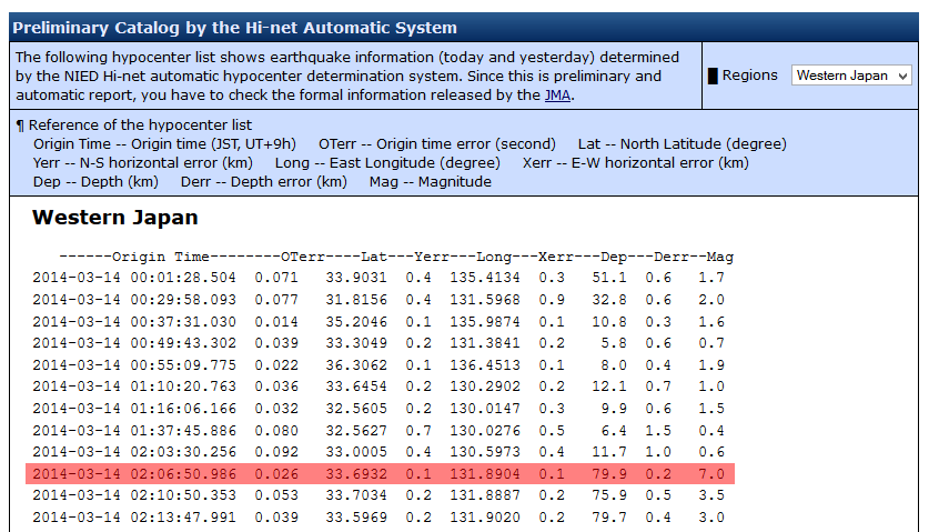
That 6.3Mw (6.6ML) Kyushu quake has been upgraded on NIED to 7.0ML!!
Aqua are still saying 6.3Mw, so not sure what this means, except a difference of TTNT energy released based on the 7.0 number, (7.0=476,879TTNT ~ 6.6=119,787TTNT), so what they are saying is, it was 4 times as powerful as they first thought!!!
A couple of early aftershocks have been removed, incl. the first one, a 4.1ML. Now showing the first a/s , a 3.5ML, at the 3:59 (mm:ss) mark.
Still only 25 aftershocks in 19 hours, that is not many at all for a J quake, could be more to come to this area yet.
Won't know for sure whats really going on until the JMA Unified Hypocenter Catalog releases the reviewed data later today for the 14th.
screenshot of the NIED download page (just to prove what I say, you have to register to get these JMA pages)
Oita,Kyushu/Inland Sea, Japan 7.0ML and aftershocks 14/03/2014 intercative map
must be where this event is headed, even the Focal parameters of the event page has changed too.
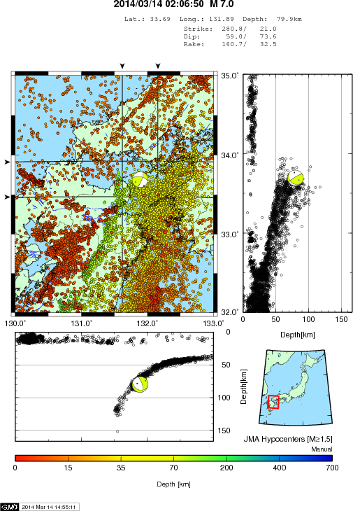
still time to edit....
I found this new page on NIED
deep low-frequency tremor in southwest Japan
just clicking through the dates backwards and found this on 2 days map images
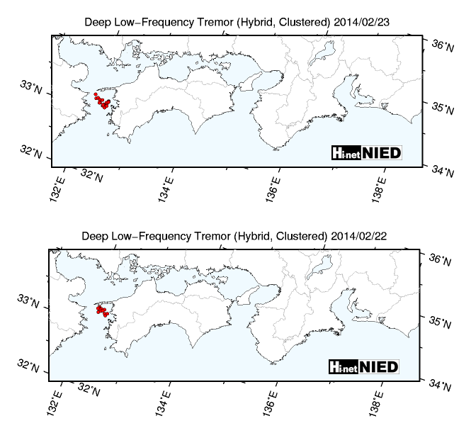
maybe this had something to do with the (now) 7.0ML??
cross referencing those with the interactive maps I do ........ bingo!!
22/03/2014
23/03/2014
Aqua are still saying 6.3Mw, so not sure what this means, except a difference of TTNT energy released based on the 7.0 number, (7.0=476,879TTNT ~ 6.6=119,787TTNT), so what they are saying is, it was 4 times as powerful as they first thought!!!
A couple of early aftershocks have been removed, incl. the first one, a 4.1ML. Now showing the first a/s , a 3.5ML, at the 3:59 (mm:ss) mark.
Still only 25 aftershocks in 19 hours, that is not many at all for a J quake, could be more to come to this area yet.
Won't know for sure whats really going on until the JMA Unified Hypocenter Catalog releases the reviewed data later today for the 14th.
screenshot of the NIED download page (just to prove what I say, you have to register to get these JMA pages)
Oita,Kyushu/Inland Sea, Japan 7.0ML and aftershocks 14/03/2014 intercative map
edit on 03u727214 by muzzy because: add TTNT numbers
edit on 03u727214 by muzzy because: missed a y
edit on
03000000727214 by muzzy because: reset the map zoom, wasn't showing all the icons, a GMaps glitch (tile defect)
must be where this event is headed, even the Focal parameters of the event page has changed too.
edit on 03u727214 by muzzy because: (no reason given)
still time to edit....
I found this new page on NIED
deep low-frequency tremor in southwest Japan
just clicking through the dates backwards and found this on 2 days map images
maybe this had something to do with the (now) 7.0ML??
cross referencing those with the interactive maps I do ........ bingo!!
22/03/2014
23/03/2014
edit on 03000000727214 by muzzy because: (no reason given)
We have debated the plate tectonic theory. And, the alternatives. I'm not saying that "other" things don't cause earthquakes (solar, moon, weather,
weather, water, magnetism, etc...), it's just that I see the plates and would have to say it's the best model.
We humans will believe what we see over what we hear, every time. We're hard-wired.
www.delhidailynews.com...
I've seen plate tectonics in the skin of cream in my coffee mug. And elsewhere.
I'll leave this new study about water in diamonds. If the findings help in the proof that water exists deep within the earth, it begs the question, how did it get there. The idea of slabs of plate being pushed deep into the mantle would do the trick. I don't think water would be present there from earth's origin. All the water within the planet would have surfaced billions of years ago. No, the water found in the diamonds is relatively new.
The world wide quakes seem to be picking up slightly. We had Northern California, down through Mexico, along with Central America, and now South America. The whole spine seems to be tingling.
Oops, forgot the diamond article.
www.nature.com...
edit on 15-3-2014 by ericblair4891 because: (no reason given)
Olivine
The little Mag 3.3 that followed 28 seconds after the 5.2, near the water's edge at Crescent City, CA, is interesting.
It was most likely triggered by the larger offshore quake.
This 3.3 must have been a "phantom" quake, because it has gone missing from the USGS listings.
What is goofy, is that USGS changed the 3.3 link to show the Mag 5.2 data. Here is what you get if you do a search on USGS
for event ID# NC72184461
M3.3 - 22km S of Bertsch-Oceanview, California 2014-03-13 19:12 ...
1 day ago ... Minimum Distance, 38.0 km (0.34°). Travel Time Residual, 0.19 sec. Azimuthal Gap, 227°. Review Status, AUTOMATIC. Event ID, nc72184461 ...
earthquake.usgs.gov/earthquakes/eventpage/nc72184461
Anyway, there are still quite a few small aftershocks occurring near the mag 6.8 epicenter, they just aren't all being posted.
Plate Boundary station 046 shows them nicely.
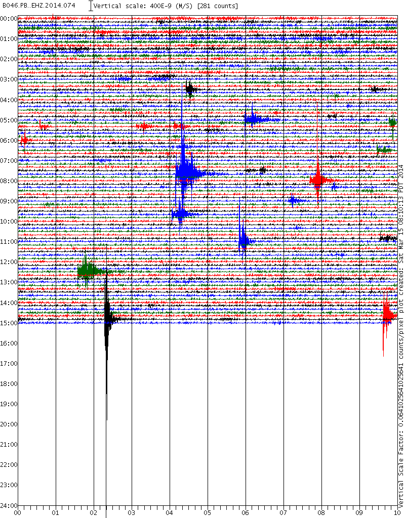 source
edit on
3/15/2014 by Olivine because: (no reason given)
Just had an earthquake here in So Cal!. Don't know where yet. Just a jolt where I am in the High Desert.
ABC7.com showing a pretty big one on their quake cam.
ABC7.com showing a pretty big one on their quake cam.
reply to post by SunnyDee
Ugh! That is a nasty spot for one: Mag 4.4 Right on the San Andreas near where the Garlock intersects.
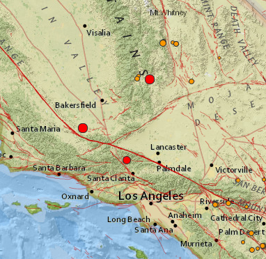
Not good.
Stay safe, Sunny Dee!
ETA: Phantom quakes removed (subject to change, of course):
source
Ugh! That is a nasty spot for one: Mag 4.4 Right on the San Andreas near where the Garlock intersects.
Not good.
Stay safe, Sunny Dee!
ETA: Phantom quakes removed (subject to change, of course):
4.0 2km SE of Weldon, California
2014-03-15 15:12:35 UTC0.0 km
3.9 13km N of Castaic, California
2014-03-15 15:12:19 UTC0.6 km
4.4 8km ESE of Maricopa, California
2014-03-15 15:12:09 UTC15.1 k
source
edit on 3/15/2014 by Olivine
because: (no reason given)
edit on 3/15/2014 by Olivine because: add a pic
edit on 3/15/2014 by Olivine because:
phantom quakes removed
reply to post by Olivine
Is that where it was located? Yes we are on a pressure point on the San Andreas around here. ABC7 that has the quake cam is not even mentioning it. Ok husband reading that 4.4 near taft. Then at one at 3.9 at Castaic dam, just south of the first one, and then a third one of 4.0 at lake Isabella, just east of taft.
Hmmm. I only felt one.
reply to post by SunnyDee
ETA: What a clusterfoook!
The firstsecond and third quakes have now disappeared, leaving just the Mag 4.4 ESE of Maricopa
Mag 3.9 N of Castaic.
Give it 5 minutes; the details will change again....
ETA: What a clusterfoook!
The first
Give it 5 minutes; the details will change again....
edit on 3/15/2014 by Olivine because: maddening revisions--you have millions of $ of
equipment--get it straight the 1st time!!!
update on post by muzzy
IYONADA SETONAIKAI, KYUSHU, JAPAN (official name for it now)
at the 30hr mark only 19 aftershocks!!
There are quite a few different magnitudes for the quake now;
6.6ML from NIED preliminary data on the day and the Backnumber of Recent Large Earthquake page (showed the pdf)
7.0ML from NIED preliminary data the next day and the Backnumber of Recent Large Earthquake page (showed you the 2nd pdf of that)
*the NIED preliminary data doesn't show whether its from displacement or velocity
6.3Mw from AQUA based on the CMT
6.3Mw from IRIS/GCMT
latest data from JMA has
6.2ML from JMA calculated on the displacement
6.1ML from JMA calculated using velocity
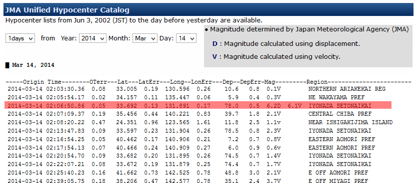
the JMA public site says 6.1, so at least we know now that that figure when posted is based on velocity.
www.jma.go.jp...
* note on that image the first aftershock has changed ( again) now a 2.3 at the 6 minute mark
(rolling eyes smiley here)
IYONADA SETONAIKAI, KYUSHU, JAPAN (official name for it now)
at the 30hr mark only 19 aftershocks!!
There are quite a few different magnitudes for the quake now;
6.6ML from NIED preliminary data on the day and the Backnumber of Recent Large Earthquake page (showed the pdf)
7.0ML from NIED preliminary data the next day and the Backnumber of Recent Large Earthquake page (showed you the 2nd pdf of that)
*the NIED preliminary data doesn't show whether its from displacement or velocity
6.3Mw from AQUA based on the CMT
6.3Mw from IRIS/GCMT
latest data from JMA has
6.2ML from JMA calculated on the displacement
6.1ML from JMA calculated using velocity
the JMA public site says 6.1, so at least we know now that that figure when posted is based on velocity.
www.jma.go.jp...
edit on 03000000737314 by muzzy because: (no reason given)
* note on that image the first aftershock has changed ( again) now a 2.3 at the 6 minute mark
(rolling eyes smiley here)
edit on 03000000737314 by muzzy because: (no reason given)
M 6.3 - 6km W of Sechura, Peru
Time
2014-03-15 18:51:30 UTC-05:00
Location
5.566°S 80.879°W
Depth
9.8km
earlier today
M 6.1 - 27km SSW of Paracas, Peru
Time
2014-03-15 03:59:20 UTC-05:00
Location
14.107°S 76.324°W
Depth
15.0km
Time
2014-03-15 18:51:30 UTC-05:00
Location
5.566°S 80.879°W
Depth
9.8km
earlier today
M 6.1 - 27km SSW of Paracas, Peru
Time
2014-03-15 03:59:20 UTC-05:00
Location
14.107°S 76.324°W
Depth
15.0km
graphic for the post by muzzy
19 hrs of aftershocks preliminary versus reviewed (animated)
nothing new in yet, not sure what time they post the reviewed data...............
stuck with the preliminary data for now, and that is proving unreliable.
19 hrs of aftershocks preliminary versus reviewed (animated)
nothing new in yet, not sure what time they post the reviewed data...............
stuck with the preliminary data for now, and that is proving unreliable.
Magnitude 6.5 earthquake strikes northwestern Peru: USGS
(Reuters) - A magnitude 6.5 earthquake struck northwestern Peru on Saturday, the U.S. Geological Survey reported. The quake's epicenter was 26 miles south-southwest of Piura and it occurred at a depth of 7.2 miles, the USGS said. There were no immediate reports of injuries or damage.
M6.3 - NEAR THE COAST OF NORTHERN PERU
Preliminary Earthquake Report
Magnitude 6.3
Date-Time
15 Mar 2014 23:51:30 UTC
15 Mar 2014 18:51:31 near epicenter
15 Mar 2014 15:51:30 standard time in your timezone
Location 5.566S 80.879W
Depth 9 km
Distances
6 km (3 mi) W of Sechura, Peru
19 km (11 mi) SSW of Vice, Peru
23 km (14 mi) SW of La Union, Peru
39 km (24 mi) SSW of Catacaos, Peru
645 km (399 mi) SSW of Quito, Ecuador
Location Uncertainty Horizontal: 0.0 km; Vertical 4.2 km
Parameters Nph = 124; Dmin = 695.7 km; Rmss = 1.00 seconds; Gp = 90°
Version =
Event ID us c000nd0c
For updates, maps, and technical information, see: Event Page or USGS Earthquake Hazards Program
National Earthquake Information Center
U.S. Geological Survey
earthquake.usgs.gov...
edit on 15-3-2014 by violet because: (no reason given)
never heard of the place before ..............
KERGUELEN ISLANDS REGION
(French Southern and Antarctic Lands)
2014/3/15 14:20:56.0
-49.00, 69.00
33.0km
5.0 Ms
AND
2014/3/15 14:57:04
-49.00, 69.00
33.0km
5.1 Ms
www.ldeo.columbia.edu...
Useless have 4.7mb for that first one??
earthquake.usgs.gov...
How Rare?
ANSS
0 km to 500 km from (-49.00,69.00)
Date, Time, Lat, Lon, Depth, Mag, Magt
1973/05/03 23:11:05.70 -46.1020, 73.2020 33.00 5.5 Ms
1980/04/24 23:44:39.60 -48.7410, 69.2400 10.00 5.0 Mb
1980/04/25 01:54:19.60 -48.7100, 69.1860 10.00 4.8 Mb
1980/04/25 15:50:05.60 -48.7940, 69.4820 10.00 5.0 Mb
1994/05/15 03:44:57.52 -48.9930, 73.6660 10.00 5.8 Mb
2007/07/28 15:32:50.85 -49.1390, 68.9770 10.00 5.3 Mw
2014/03/12 18:15:10.53 -49.3281, 69.6089 14.37 4.9 Mb
2014/03/15 14:20:59.38 -49.3807, 69.4336 10.00 4.7 Mb
reply to post by muzzy
Hey Muzzy, seems to be one missing from 1986/7.
Everything else is around every 7 years.
P
0 km to 500 km from (-49.00,69.00) Date, Time, Lat, Lon, Depth, Mag, Magt
1973/05/03 23:11:05.70 -46.1020, 73.2020 33.00 5.5 Ms
1980/04/24 23:44:39.60 -48.7410, 69.2400 10.00 5.0 Mb
1980/04/25 01:54:19.60 -48.7100, 69.1860 10.00 4.8 Mb
1980/04/25 15:50:05.60 -48.7940, 69.4820 10.00 5.0 Mb
1994/05/15 03:44:57.52 -48.9930, 73.6660 10.00 5.8 Mb
2007/07/28 15:32:50.85 -49.1390, 68.9770 10.00 5.3 Mw
2014/03/12 18:15:10.53 -49.3281, 69.6089 14.37 4.9 Mb
2014/03/15 14:20:59.38 -49.3807, 69.4336 10.00 4.7 Mb
Hey Muzzy, seems to be one missing from 1986/7.
Everything else is around every 7 years.
P
No Mag 6's in Chile since 31 Oct 2013 ......
just sayin'
s'pose they deserved a break
actually there were only two the whole of 2013
five in 2012
just sayin'
s'pose they deserved a break
actually there were only two the whole of 2013
five in 2012
reply to post by muzzy
Location in Google Maps
Derived from Event Data Source: USGS
Powered by QVSData
EMSC showing 6.5 at present
www.emsc-csem.org...
Magnitude 7.0 - Near Coast Of Northern Chile (122) [F]
Location in Google Maps
- Date-Time: Sunday, March 16, 2014 @ 21:16:31 UTC
- Earthquake location: 19.902°S, 70.659°W,
- Earthquake depth: 33.0 km
- Distances:
64km (39mi) WNW of Iquique, Chile
162km (100mi) SSW of Arica, Chile
214km (132mi) SSW of Tacna, Peru
247km (153mi) N of Tocopilla, Chile
460km (285mi) SW of La Paz, Bolivia
- Event ID: pt14075001
Derived from Event Data Source: USGS
Powered by QVSData
EMSC showing 6.5 at present
Magnitude M 6.5
Region OFFSHORE TARAPACA, CHILE
Date time 2014-03-16 21:16:30.0 UTC
Location 19.97 S ; 70.65 W
Depth 10 km
Distances 466 km SW of La Paz, Bolivia / pop: 812,799 / local time: 17:16:30.0 2014-03-16
60 km NW of Iquique, Chile / pop: 227,499 / local time: 17:16:30.0 2014-03-16
www.emsc-csem.org...
edit on 16/3/2014 by PuterMan because: (no reason given)
reply to post by PuterMan
EMSC has now 7.0 too
Magnitude Mw 7.0
Region OFFSHORE TARAPACA, CHILE
Date time 2014-03-16 21:16:30.0 UTC
Location 19.85 S ; 70.57 W
Depth 10 km
Distances 451 km SW of La Paz, Bolivia / pop: 812,799 / local time: 17:16:30.0 2014-03-16
61 km NW of Iquique, Chile / pop: 227,499 / local time: 17:16:30.0 2014-03-16
EMSC
new topics
-
Say his name
US Political Madness: 38 minutes ago -
There is no such thing as moonlight.
Space Exploration: 1 hours ago -
Breaking: 5 probed after 18-year old girl dies as a result of having the COVID jab
Diseases and Pandemics: 2 hours ago -
Official denial
Diseases and Pandemics: 5 hours ago -
MEGA - Let's Make Europe Great Again
Other Current Events: 5 hours ago -
Hamas and Other Islamist Terrorist Groups Announce Support of US Campus Anti-Israel Protests
Education and Media: 6 hours ago -
Psychotronic Operation Rwanda Who Wants To Be A Refugee?
ATS Skunk Works: 6 hours ago
top topics
-
Breaking: 5 probed after 18-year old girl dies as a result of having the COVID jab
Diseases and Pandemics: 2 hours ago, 9 flags -
Hamas and Other Islamist Terrorist Groups Announce Support of US Campus Anti-Israel Protests
Education and Media: 6 hours ago, 5 flags -
Official denial
Diseases and Pandemics: 5 hours ago, 5 flags -
AI phrenology
Science & Technology: 13 hours ago, 4 flags -
Psychotronic Operation Rwanda Who Wants To Be A Refugee?
ATS Skunk Works: 6 hours ago, 4 flags -
MEGA - Let's Make Europe Great Again
Other Current Events: 5 hours ago, 3 flags -
There is no such thing as moonlight.
Space Exploration: 1 hours ago, 2 flags -
Say his name
US Political Madness: 38 minutes ago, 2 flags
active topics
-
Please share your paranormal & ghost experiences!!
Paranormal Studies • 145 • : Lochid -
Biden "Happy To Debate Trump"
2024 Elections • 71 • : CarlLaFong -
The adventure of publishing books
People • 8 • : DISRAELI2 -
There is no such thing as moonlight.
Space Exploration • 5 • : TheMichiganSwampBuck -
Gov Kristi Noem Shot and Killed "Less Than Worthless Dog" and a 'Smelly Goat
2024 Elections • 93 • : FlyersFan -
Hate makes for strange bedfellows
US Political Madness • 62 • : network dude -
Say his name
US Political Madness • 1 • : DAVID64 -
Breaking: 5 probed after 18-year old girl dies as a result of having the COVID jab
Diseases and Pandemics • 11 • : CarlLaFong -
Thousands Of Young Ukrainian Men Trying To Flee The Country To Avoid Conscription And The War
Other Current Events • 143 • : Xtrozero -
Krystalnacht on today's most elite Universities?
Social Issues and Civil Unrest • 26 • : ToneD