It looks like you're using an Ad Blocker.
Please white-list or disable AboveTopSecret.com in your ad-blocking tool.
Thank you.
Some features of ATS will be disabled while you continue to use an ad-blocker.

Volcano Watch 2014
page: 47share:
O.k.....these were all updated 2 hours & 5 minutes ago.....
Kilauea, U.S.
Ambrym, Vanuatu
Slamet, Indonesia
Nishinoshima, Japan
Mayon, Philippines
Kusatsu, Shiranesan Japan
Kuchinoerabujima, Japan
Bandarbunga, Iceland
Asosan,Japan
Askja, Iceland
I find it odd they all alerted at exactly the same time????? Maybe the machines went down???? They ALL say exactly 2 hours & 5 minutes ago.....
Actually, I think I see some of the ones I named here on this link as being NEW: www.volcano.si.edu...
Add Russia to the list. Volcano there just set off as I was typing this.....odd
Kilauea, U.S.
Ambrym, Vanuatu
Slamet, Indonesia
Nishinoshima, Japan
Mayon, Philippines
Kusatsu, Shiranesan Japan
Kuchinoerabujima, Japan
Bandarbunga, Iceland
Asosan,Japan
Askja, Iceland
I find it odd they all alerted at exactly the same time????? Maybe the machines went down???? They ALL say exactly 2 hours & 5 minutes ago.....
Actually, I think I see some of the ones I named here on this link as being NEW: www.volcano.si.edu...
edit on 9/17/14
by j.r.c.b. because: (no reason given)
Add Russia to the list. Volcano there just set off as I was typing this.....odd
edit on 9/17/14 by j.r.c.b. because: (no reason given)
a reply to: batcrapcrazy
yeah I think a 6.0 might do it, that would be the sudden collapse of the whole plug of earth above the lava chamber, probably cause some kind of eruption there at the caldera.
But no one knows for sure what will happen.
yeah I think a 6.0 might do it, that would be the sudden collapse of the whole plug of earth above the lava chamber, probably cause some kind of eruption there at the caldera.
But no one knows for sure what will happen.
a reply to: BobAthome
yeah Google was down by the look of it, all images are appearaing now, 8 hours later.
Dropbox rarely went down, unfortunately I have used up the free data storage available (took 6 years) and have to pay to add more. I opened a new free Dropbox account but haven't figured out how it works yet, the layout is totally different, again the "improved version" blah! yeah right, just like Google Maps' and Wordpress' "new improved versions" not to mention Windows 8
Why can't they just let things alone if they work and stop fiddling with a good system!!!
I have yet to find a "new version" that is better than the old one yet!
ATS included.
*edit.
Well it looks like user pays again.
Dropbox accounts set up after October 4, 2012 no longer have a Public folder for sharing files on Forums, Blogs etc.
Old accounts still work until they are full.
$99 for a year! to upgrade to Dropbox Pro
geez this is only a hobby, screw that.
Looks like we are stuck with Google Dive (Drive), lets hope it doesn't error out too often.
edit on 0900000026026014 by muzzy because: (no
reason given)
a reply to: SeekingDepth
Thanks, that was some good information !
Nice volcano actual, it would be sad if it gets messed up with a big eruption.
Thanks, that was some good information !
Nice volcano actual, it would be sad if it gets messed up with a big eruption.
a reply to: muzzy
I was going to add but went for dinner instead.......
50cm deflection per 24 hours (when the bigger 5.5's hit) sounds a lot, but that is only 500mm or 18 inches, spread over what? 2km area
Not that big of a deal, how thick is the plug? 5-10km?
long way to go yet
I was going to add but went for dinner instead.......
50cm deflection per 24 hours (when the bigger 5.5's hit) sounds a lot, but that is only 500mm or 18 inches, spread over what? 2km area
Not that big of a deal, how thick is the plug? 5-10km?
long way to go yet
edit on 0900000026026014 by muzzy because: (no reason given)
a reply to: muzzy
“Villagers living near the volcano have erected huge white crosses at the entrance of their neighborhoods, hoping they will protect them from harm.”
www.mb.com.ph...
Just out of curiosity I wonder if the 1/2 life of the white crosses are any longer than any other material available. amazing how when faced with extreme conditions some people tend to fall to the ground and expect supreme intervention.
Check out this weather radar from the Bardarbunga/Holuhraun area, courtesy of the
IMO.
(and thanks to Jon Frimann blog commentor "Gil" for posting the link.)
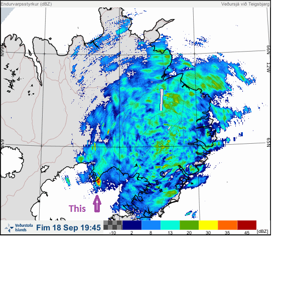
I believe that location may be near one of the "cauldrons" reported a week or two ago.
Looking at the map again, I think the cauldrons were west and south of the "red blob".
If you use the slider below the image to go back in time, you'll notice that dark red blob near Kverkfjoll (near the glacier edge) stays put.
What is it? Gases, ash, miscellaneous anomoly?
(and thanks to Jon Frimann blog commentor "Gil" for posting the link.)
Looking at the map again, I think the cauldrons were west and south of the "red blob".
If you use the slider below the image to go back in time, you'll notice that dark red blob near Kverkfjoll (near the glacier edge) stays put.
What is it? Gases, ash, miscellaneous anomoly?
edit on 9/18/2014 by Olivine because: (no reason given)
edit on 9/18/2014 by
Olivine because: (no reason given)
a reply to: Olivine
yeah it is kind of strange, even though that storm that is shown in your screenshot has passed the red area is still there.
dBZ might be the key
en.wikipedia.org...
need more information
maybe its a geyser!?
yeah it is kind of strange, even though that storm that is shown in your screenshot has passed the red area is still there.
dBZ might be the key
en.wikipedia.org...
In combination with other information gathered by the radar during the same scan (dual polarization products and phase shifting due to the Doppler effect), meteorologists can distinguish between hail, rain, snow, biologicals (birds, insects), and other atmospheric phenomena.
need more information
maybe its a geyser!?
relatively heavy day for earthquakes 18th Sept, 164 of them, up 50 from recent averages
volcanictremor.wordpress.com...
volcanictremor.wordpress.com...
edit on 09u26026014 by muzzy because: (no reason
given)
edit on 09u26126114 by muzzy because: (no reason given)
a reply to: muzzy
I think it may be heat from fumaroles atop Kverkfjoll, causing steam that just blown east a bit.
Going back through the archive, I checked a few days in July, before the Bardy activity began. Some days this "red blob" signature was there, but much smaller,.other days it wasn't there at all.
Either it was too warm to create steam clouds, or maybe the new volcano-tectonic activity jump started the plumbing under Kverkfjoll....dunno.
According to the latest IMO update (2-page .pdf), the lava erupting in Holuhraun has origins greater than 10 km deep.
I really wish the drumplots would re-appear.
I think it may be heat from fumaroles atop Kverkfjoll, causing steam that just blown east a bit.
Going back through the archive, I checked a few days in July, before the Bardy activity began. Some days this "red blob" signature was there, but much smaller,.other days it wasn't there at all.
Either it was too warm to create steam clouds, or maybe the new volcano-tectonic activity jump started the plumbing under Kverkfjoll....dunno.
According to the latest IMO update (2-page .pdf), the lava erupting in Holuhraun has origins greater than 10 km deep.
Chemical analysis and modelling, of the magma coming up in the Holuhraun eruption, indicates that the magma is
coming up from a depth of more than 10 km.
I really wish the drumplots would re-appear.
6424 earthquake events since 11/08/2014 in the area covered by the IMO maps on
this page ) (Vatnajokull) up to 19/09/2014 11:50:06UTC
mag less than 1= 1740
mag1= 3615
mag2= 944
mag3= 50
mag4= 49
mag5= 26 (biggest 5.54)
total= 6424
Those numbers are based on events above 4M are mb, below are ML, I don't think they are Mw as I had a look at IRIS and most of theirs were mb, they only had 22 x M5's all up.
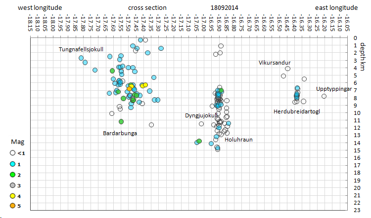
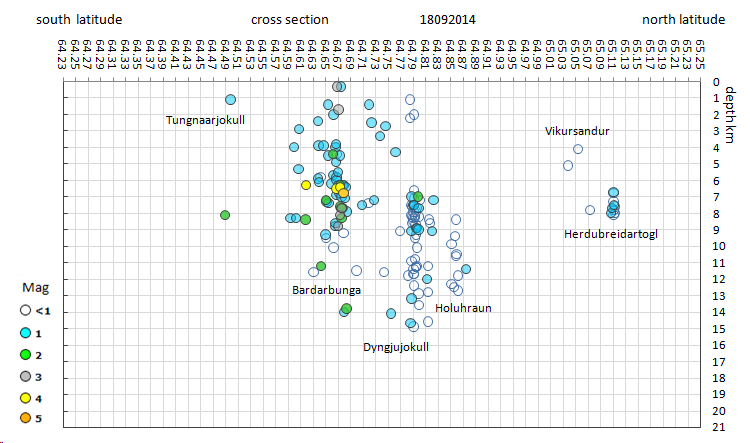
here is a map of the M5's for now
If we just used ML there wouldn't have been any M5's yet!!
Couple of things jump out at me from that map
Appears the 5's are to the east of the caldera itself, under the flanks of the volcano cone. That may indicate that the caldera itself is dry of lava, hense the slow collapse of it (maybe)
The Google maps are useless to see the topography of the cone under the ice. I'll put those markers on the topo map I can get from GPS Visualiser.
There was a 5 over on the edge of the Dyngjujokull glacier on my daily data, which has gone now, perhaps they had the location wrong or it got down graded to a 4. I'll check on that later.
Hmm, not sure where the caldera actually is now!! there are not enough detail heights to figure it out at the top
based on this entry from the Google Earth mountain icon, which in turn is from Wikipedia
what we need is a cross section of the geography of the cone showing the caldera
mag less than 1= 1740
mag1= 3615
mag2= 944
mag3= 50
mag4= 49
mag5= 26 (biggest 5.54)
total= 6424
Those numbers are based on events above 4M are mb, below are ML, I don't think they are Mw as I had a look at IRIS and most of theirs were mb, they only had 22 x M5's all up.
here is a map of the M5's for now
If we just used ML there wouldn't have been any M5's yet!!
Couple of things jump out at me from that map
Appears the 5's are to the east of the caldera itself, under the flanks of the volcano cone. That may indicate that the caldera itself is dry of lava, hense the slow collapse of it (maybe)
The Google maps are useless to see the topography of the cone under the ice. I'll put those markers on the topo map I can get from GPS Visualiser.
There was a 5 over on the edge of the Dyngjujokull glacier on my daily data, which has gone now, perhaps they had the location wrong or it got down graded to a 4. I'll check on that later.
edit on 09u26126114 by muzzy because: (no reason given)
Hmm, not sure where the caldera actually is now!! there are not enough detail heights to figure it out at the top
based on this entry from the Google Earth mountain icon, which in turn is from Wikipedia
The Bárðarbunga caldera is about 70 square kilometres, up to 10 kilometres wide and about 700 metres deep. The surrounding edges rise up to 1850 metres but the base is on average close to 1100 metres. The volcano is covered in ice, hiding the glacier-filled crater.
what we need is a cross section of the geography of the cone showing the caldera
edit on 09u26126114 by muzzy because: (no reason
given)
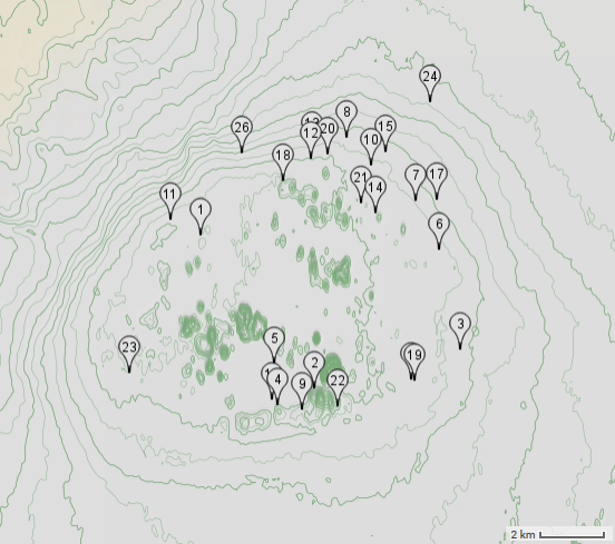
Spent a bit of time searching, still can't find a decent cross section of Bardarbunga.
But I found a good topographical map of the caldera, on volcano cafe, by avalonlightphotoart
HEY the bastards stole my KML files!!!!!! I'd recognise those icons anywhere, they are mine!
volcanocafe.wordpress.com...-148234
But at least he/she (RC) gave me credit with a link to my blog, next reply down.
I'll return the flavour and steal his topo overlay for Google Earth, to plot my M5's
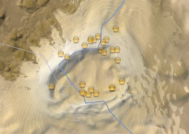
so they were close to the rim after all
that OpenCycleMap.org topo map I used must be really old.
But I found a good topographical map of the caldera, on volcano cafe, by avalonlightphotoart
HEY the bastards stole my KML files!!!!!! I'd recognise those icons anywhere, they are mine!
volcanocafe.wordpress.com...-148234
But at least he/she (RC) gave me credit with a link to my blog, next reply down.
I'll return the flavour and steal his topo overlay for Google Earth, to plot my M5's
so they were close to the rim after all
that OpenCycleMap.org topo map I used must be really old.
edit on 0900000026126114 by muzzy because: (no reason given)
Photographer Bernard Meric September 15
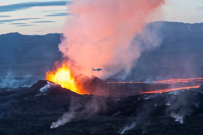
icelandreview.com...
200-250 million cubic meters (7.1-8.8 billion cubic feet)
icelandreview.com...
link
The size of the lava flow is now estimated to be 25-30 square km (9.7-11.6 square miles), which makes it one of the largest eruptions in Iceland since the 19th century.
200-250 million cubic meters (7.1-8.8 billion cubic feet)
Mother Nature is awesome!
That is a beautiful photo.
Thanks Muzzy
P
That is a beautiful photo.
Thanks Muzzy
P
edit on 19/9/2014 by pheonix358 because: (no reason given)
new topics
-
Lemon-aid and lime-aid
General Chit Chat: 46 minutes ago -
Multipal Solar Storms Coming Our Way This Weekend
Fragile Earth: 1 hours ago -
US food sources declining becoming non edible .
Social Issues and Civil Unrest: 2 hours ago -
Journalism Against Judaism
Middle East Issues: 8 hours ago
top topics
-
Bibi’s Dilemma
Middle East Issues: 13 hours ago, 11 flags -
Proof of Cleptocracy
US Political Madness: 16 hours ago, 10 flags -
Journalism Against Judaism
Middle East Issues: 8 hours ago, 4 flags -
US food sources declining becoming non edible .
Social Issues and Civil Unrest: 2 hours ago, 4 flags -
Multipal Solar Storms Coming Our Way This Weekend
Fragile Earth: 1 hours ago, 4 flags -
Lemon-aid and lime-aid
General Chit Chat: 46 minutes ago, 1 flags
active topics
-
Lemon-aid and lime-aid
General Chit Chat • 3 • : chr0naut -
US food sources declining becoming non edible .
Social Issues and Civil Unrest • 17 • : rickymouse -
Israeli strikes on southern Gaza city of Rafah kill 22, mostly children, as US advances aid package
Middle East Issues • 203 • : BernnieJGato -
Judge Postpones Trump Classified Docs Trial INDEFINITELY
US Political Madness • 169 • : chr0naut -
Multipal Solar Storms Coming Our Way This Weekend
Fragile Earth • 7 • : charlest2 -
Boy Scouts to be renamed next year
Other Current Events • 186 • : GENERAL EYES -
Social Security projected to cut benefits in 2035 barring a fix
Global Meltdown • 47 • : BernnieJGato -
Candidate TRUMP Now Has Crazy Judge JUAN MERCHAN After Him - The Stormy Daniels Hush-Money Case.
Political Conspiracies • 1450 • : CarlLaFong -
New House GOP Bill To Send Pro Hamas College Law Breakers to Gaza for 6 Months
Social Issues and Civil Unrest • 125 • : DBCowboy -
Gov Kristi Noem Shot and Killed "Less Than Worthless Dog" and a 'Smelly Goat
2024 Elections • 180 • : cherokeetroy