It looks like you're using an Ad Blocker.
Please white-list or disable AboveTopSecret.com in your ad-blocking tool.
Thank you.
Some features of ATS will be disabled while you continue to use an ad-blocker.

Volcano Watch 2014
page: 44share:

perhaps this type of graph might be more helpful than a 30 day depth graph
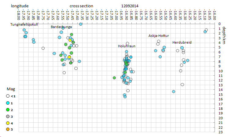
hopefully right click view image to see full size
It took me ages to build a Template so that I can get them consistent, its near impossible to match the map and graph directly, due to different scales.
On the graph the locations of the swarms of quakes are marked for reference and should be viewed in conjunction with the daily maps. The markers on the depth graph are coloured by magnitude (I wanted to see in 3D compared to the maps which are only 1D. )
What this graph shows me is;
1. We have 4 seperate swarms of earthquakes going on here (which we already knew from the maps)
2. The Holuhraun fissure (eruption site) goes quite deep (17km)
and it raises a few questions;
1. Is the eruption actually being fed by separate magma from the core? (not from Bardarbunga)
2. Is Bardarbunga already empty of magma? (as there is no earthquake activity below 10.4km)
3. Perhaps the Caldera collapse is just the plug going down and filling the space where the magma was before, and it does not necessarily mean a big eruption there if it suddenly drops.
maybe I'm way off track with that, but hey who knows!
edit on 09u25525514 by muzzy because: I'll do another one or two graphs randomly selected
from the daily data I have archived and seek confirmation

According to the last data there is inflation at GFUM and GSIG
VONC and DYNC show deflation although at DYNC it is going up and down so i expect some inflation at DYNC in the next day(s).
Look at the stations on this page.
Also HRIC near Askja shows there is inflation, sadly THOC does not work properly.
So there is still more magma flowing in than out, two stations GFUM and GSIG are placed near Grímsvötn and Kverkfjöll.

The eruption at holuraun is still ongoing albeit reduced somewhat since yesterday.

Big
Sept 13 14:20
Well, one cam is viable so far today

The other is a whiteout. Meh, not bothering.
And now for the news.
Sunk about half a meter last day
www.ruv.is...
There is a brief time lapse video at the bottom worth watching.
Sigmund David flew over the eruption
www.ruv.is...
???? Must be a big wig?
Encouraged to keep abreast of measurements
www.ruv.is...
Interestingly enough they were advising people keep their houses shut to run their furnaces hotter, during the high levels.
"Like breathing from the exhaust pipe"
www.ruv.is...
M.
The other is a whiteout. Meh, not bothering.
And now for the news.
Sunk about half a meter last day
www.ruv.is...
Bardarbunga has sunk about half a meter past the clock. This shows GPS - speaks Bárðarbunga. Prognosis eruption of lava pocket and continued on their own are the same. This was stated by scientists Council meeting this morning. Lava flows on the Jokulsa the mountains.
The area of lava is now 24.5 square kilometers. The volume of lava is now estimated that at least 200 million cubic meters. Gasský leaves the eruption site and the warning was sent out by sms - messages to all mobile Fjarðabyggð last night when a very high concentration of sulfur was measured Reyðafirði about ten o'clock last night.
There is a brief time lapse video at the bottom worth watching.
Sigmund David flew over the eruption
www.ruv.is...
Sigmund David - the Prime Minister - since appointed panel 's response to natural disasters. Group to review the requirement and cost of individual entities and organizations because of the volcanic eruption in hollow lava and earthquakes in and around the caldera Bárðarbunga in Dyngjujökli.
???? Must be a big wig?
Encouraged to keep abreast of measurements
www.ruv.is...
Has diminished concentration of sulfur dioxide in the plant, but was, now just eight more than 350 micrograms per cubic meter. Concentration reached almost 4,000 micrograms last night its highest rate since begun to measure the concentration of sulfur dioxide from the eruption of lava blowout.
Interestingly enough they were advising people keep their houses shut to run their furnaces hotter, during the high levels.
"Like breathing from the exhaust pipe"
www.ruv.is...
Last night, unprecedented pollution levels were measured in Reydarfjordur, one of the town and villages on Iceland´s east coast. Around 23.00 PM, the sulfur dioxide reached 4000 micrograms/m³ (1526 ppm), but subsided rapidly after that. Inhabitants were advised to stay indoors, close windows and heat their homes to keep the pollution out. High levels were also recorded in other towns nearby, such as Neskaupstadur and Egilsstadir.
The incident last night in Reydarfjordur is at least the second time in recent days when a sulfur dioxide pollution has reached hazardous levels. Two days ago, sulfur dioxide was measured to be 2600 micrograms/m³, which was then a record. The pollution was described as a cloud, sweeping over the village. "This felt like standing behind a lorry, breathing the exhaust straight from the engine," said an inhabitant, according to the Environment Agency of Iceland.
M.


I was making a new template for the cross sections (mentioned last night) and just noticed that after doing 2 days of posts with the map and graph
then stretching back in the chair and thinking "yep that looks good" .............
I hadn't published them!, only I could see them!!!
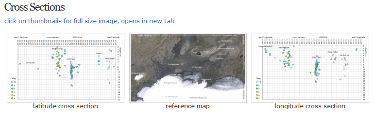
So I've taken the opportunity to add a new feature, both latitude and longitude cross sections
click on image for link to page
I hadn't published them!, only I could see them!!!
So I've taken the opportunity to add a new feature, both latitude and longitude cross sections
click on image for link to page
edit on 0900000025525514 by muzzy because: (no reason given)
I see the verdur data is back up and running, up till 3/4hr ago, that is pretty good. hraun.vedur.is...
I'll keep the few days I did off the 48hr list for now, too much work to change them, and its easier to just use the Vatnajökull page to get the data, saves a bit of time cropping the verdur reviewed list, I notice that that the Vatnajökull page now has 99% quality for all on the list a day back, so that will do. The wrinkles will come out when I do the Iceland monthly maps at the end of the month.
I'll keep the few days I did off the 48hr list for now, too much work to change them, and its easier to just use the Vatnajökull page to get the data, saves a bit of time cropping the verdur reviewed list, I notice that that the Vatnajökull page now has 99% quality for all on the list a day back, so that will do. The wrinkles will come out when I do the Iceland monthly maps at the end of the month.
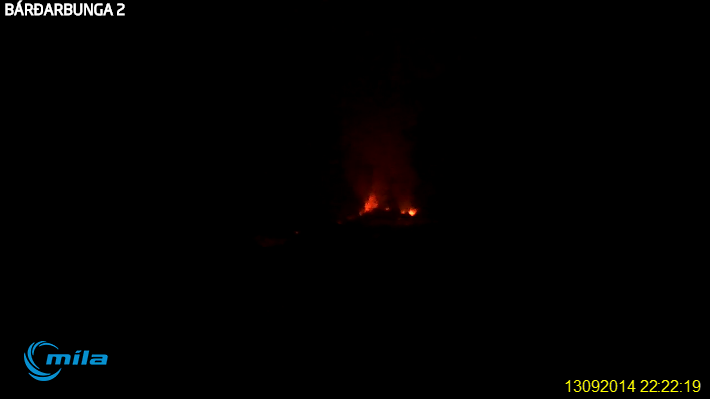
bit of fire at the fissure right now, been a few days now all smoke

left click for bigger image (not much bigger, 710px)

left click for bigger image (not much bigger, 710px)
edit on 09u25525514 by muzzy because: (no reason given)
a reply to: muzzy
Looks good indeed
Beneath Bardarbunga the earthquakes are still quite shallow with a depth of 2.5 to 5 kilometer and a deep strait line beside it which is beneath the edge of the glacier.
Back in August the migration was visible when looking at the colors.


Looks good indeed
Beneath Bardarbunga the earthquakes are still quite shallow with a depth of 2.5 to 5 kilometer and a deep strait line beside it which is beneath the edge of the glacier.
Back in August the migration was visible when looking at the colors.
a reply to: earthling42
thanks. I'm not clever enough to make my graphs rotate though.
This time of day (evening over there) seems to give the best web cam shots, twilight shows the lava fountains quite well.
Its a pity they can't get better quality out of the closer cam2 images, then we could check the height of the lava cones compared to earlier. Not much we can do about the haze (smoke?) or the weather I guess.
a reply to: Dolby_X
no I mean my graphs
That one earthling showed is quite good for the interactivity
they use 3 axis to get the 3D effect
but I'd rather see it on a daily basis
I've lost the link for that
no I mean my graphs
That one earthling showed is quite good for the interactivity
they use 3 axis to get the 3D effect
but I'd rather see it on a daily basis
I've lost the link for that
edit on 0900000025525514 by muzzy because: (no reason given)
I know the webcam2 is always a bit fuzzy, due to smoke/weather/zoom length (18km), but I'm wondering if they don't have a filter on it too?
I took these two screenshots just a while ago, the first one is quite spectacular and I expected wc2 to be very bright, but what a dud!

taken 14 seconds later web cam 2
are they from the same camera, just different zoom levels?
Looks like I've got the night shift!, usually pretty boring
I took these two screenshots just a while ago, the first one is quite spectacular and I expected wc2 to be very bright, but what a dud!

taken 14 seconds later web cam 2

are they from the same camera, just different zoom levels?
Looks like I've got the night shift!, usually pretty boring
The collapse of Bárðarbunga volcano
The collapse of Bárðarbunga volcano has already started. The caldera collapse in Bárðarbunga volcano started on 16-August-2014 and has been going on since then. Here is what I am expecting from the caldera collapse once it reaches its peak.
There are going to be earthquakes in the range of 5,5 and up to 6,7. Maybe larger if the crust can handle it.
Glacier flood are going to go south-west and north (Húsavík area) and possibly in other directions. I am expecting damage to hydrothermal plants in the pathway of the floods. How much damage there is going to be depends on the magnitude of the flood and the path it takes.
I am expecting long periods of no power in parts of Iceland once the flood has passed. I am also expecting lack of communications in large areas of Iceland. This is why Rúv has been telling people to get long-wave radios for the past few days. Usage of mobile network is also going to be unreliable in large parts of Iceland once the collapse starts full force in Bárðarbunga volcano. Due to damage that glacier floods are going to create.
I am expecting an ash cloud that might go up to 20 km or higher up in the atmosphere. It is however impossible to know for sure what happens until this starts.
It is difficult to know fore sure how much drop is going to take place, but it can be up to many hundreds of meters.
I fear that north slope of Bárðarbunga might collapse forward once this starts. Earthquakes in the area give clues about weakness forming there.
Bárðarbunga volcano is 2009 meters high above the ocean. This means there is a lot of material that is going to blow outwards once the collapse starts full force. This is might be one of largest eruptions in Iceland since it got populated more than one thousands years ago. I am hoping that the picture that I am drawing up is not as bad the reality once this starts. I am also hoping that no loss of life is going to happen. I am hoping for the best in this case, but the clues that I am getting are no good at all.
www.jonfr.com...
Update on the current situation. If this guy is right, this could be a really devastating event for Iceland. Hopefully it doesn't go in this direction.
edit on 13-9-2014 by DAZ21 because: (no reason given)
a reply to: DAZ21
Although i am not a scientist in this field, i do want to make some comments on his blog.
Indeed we don't know what will happen in de coming days weeks or months, but i think we should expect new fissures to open, maybe the spot under the glacier where the little earthquakes occur, or somewhere east of the current fissure eruption.
I would not speculate on the worst like he does, there is still a possibility that this will stop, or continues to erupt and form new fissures, third, yes an eruption within the caldera itself.
It is always good to be prepared, so in that light the warnings from RUV are quite understandable, but that does not mean the worst is going to happen, it is a possible scenario, not a certainty.
new topics
-
Gallant Opposes Israeli Governance of Gaza
Middle East Issues: 50 minutes ago -
Biden plans executive order to shut down border once crossings reach 4,000 per day
US Political Madness: 2 hours ago -
Mebendazole Video
Medical Issues & Conspiracies: 3 hours ago -
ETA Found Thanks - I need help finding the ATS GOLD content contributor Image
General Chit Chat: 6 hours ago -
Biden accepts Trumps debate challenge
2024 Elections: 7 hours ago -
Canada wants to kill off the brown people
Mainstream News: 7 hours ago -
10 Year Old Indiana Boy Victim of Bullying Commits Suicide
Education and Media: 10 hours ago -
Want Some Secret Knowledge?
Paranormal Studies: 10 hours ago -
Slovakian prime minister shot in 'brutal' attack while meeting supporters
Mainstream News: 10 hours ago -
WATCH 1740 Russian Soldiers Destroyed By Ukrainian Forces While Advancing In Kharkiv
World War Three: 11 hours ago
top topics
-
Ohio finds over 100 non-citizens on votrer roles
US Political Madness: 14 hours ago, 13 flags -
Biden accepts Trumps debate challenge
2024 Elections: 7 hours ago, 10 flags -
10 Year Old Indiana Boy Victim of Bullying Commits Suicide
Education and Media: 10 hours ago, 9 flags -
Biden plans executive order to shut down border once crossings reach 4,000 per day
US Political Madness: 2 hours ago, 9 flags -
Slovakian prime minister shot in 'brutal' attack while meeting supporters
Mainstream News: 10 hours ago, 8 flags -
Mebendazole Video
Medical Issues & Conspiracies: 3 hours ago, 7 flags -
Canada wants to kill off the brown people
Mainstream News: 7 hours ago, 5 flags -
Meeting of a Russian hunter with a bear
ATS Skunk Works: 15 hours ago, 4 flags -
Want Some Secret Knowledge?
Paranormal Studies: 10 hours ago, 3 flags -
ETA Found Thanks - I need help finding the ATS GOLD content contributor Image
General Chit Chat: 6 hours ago, 3 flags
active topics
-
The biggest problem with the Hush money trial
US Political Madness • 254 • : JadedGhost -
Mood Music Part VI
Music • 3209 • : YourHighness -
Meeting of a Russian hunter with a bear
ATS Skunk Works • 33 • : andy06shake -
Slovakian prime minister shot in 'brutal' attack while meeting supporters
Mainstream News • 17 • : Zanti Misfit -
Gaza Genocide Real or Propaganda
Middle East Issues • 422 • : cherokeetroy -
Canada wants to kill off the brown people
Mainstream News • 10 • : FarqQ -
10 Year Old Indiana Boy Victim of Bullying Commits Suicide
Education and Media • 28 • : FarqQ -
Biden plans executive order to shut down border once crossings reach 4,000 per day
US Political Madness • 23 • : Zanti Misfit -
Gallant Opposes Israeli Governance of Gaza
Middle East Issues • 4 • : CriticalStinker -
15.6 Percent of US Population Now Foreign Born - 51.6 Million
Social Issues and Civil Unrest • 64 • : FarqQ