It looks like you're using an Ad Blocker.
Please white-list or disable AboveTopSecret.com in your ad-blocking tool.
Thank you.
Some features of ATS will be disabled while you continue to use an ad-blocker.

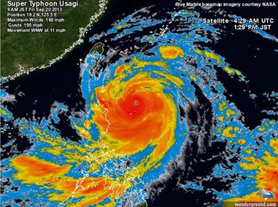
Super typhoon Usagi, strongest storm on Earth in 2013, may strike Hong Kong Sunday
page: 1share:
S
uper typhoon Usagi, strongest storm on earth in 2013..
Just got this off a local storm chasers Facebook -
Edit to add more links: Initial facebook page where I got the info
South China Morning Post
NOAA satellites
Wunderground link
- This looks like one to watch, I'm not entirely sure, but I'm sure there will be a lot of smaller coastal communities that could potentially be affected by this on the coasts of China & Taiwan, they said the coasts will experience large storm surges, so I'm really hoping people take it seriously and secure what they can and find somewhere a bit safer until it dissipates.
Just got this off a local storm chasers Facebook -
The storm – named Usagi – has achieved super typhoon status, after an amazing burst in its peak winds from 75 mph Tuesday to over 160 mph today. (Typhoons become “super typhoons” if their peak winds reach 150 mph or higher). It is now equivalent to a category 5 hurricane.
Edit to add more links: Initial facebook page where I got the info
South China Morning Post
NOAA satellites
Wunderground link
- This looks like one to watch, I'm not entirely sure, but I'm sure there will be a lot of smaller coastal communities that could potentially be affected by this on the coasts of China & Taiwan, they said the coasts will experience large storm surges, so I'm really hoping people take it seriously and secure what they can and find somewhere a bit safer until it dissipates.
edit on 20/9/2013 by bkaust because: Add more
links
reply to post by bkaust
I suspect its being named usagi [rabbit, bunny]
was hopeful thinking
unless it's a sailor moon reference...
I suspect its being named usagi [rabbit, bunny]
was hopeful thinking
unless it's a sailor moon reference...
Metaphysique
reply to post by bkaust
I suspect its being named usagi [rabbit, bunny]
was hopeful thinking
unless it's a sailor moon reference...
God, I haven't watched sailor moon in about 16 years. I used to be late to school every morning waiting for it to finish!
I think it may have been because it was initially blowing about 120/kmph so they were probably, like you said, wishful thinking that that was around what it'd stay!
From the Weather FB
In the last 24 hours, a cyclone in the west Pacific has explosively intensified, and is on a track towards Hong Kong.
The storm – named Usagi – has achieved super typhoon status, after an amazing burst in its peak winds from 120km/h Tuesday to over 257km/h today. It is now equivalent to a category 5 hurricane.
Usagi is now the strongest storm to form on Earth in 2013. -Kristal
reply to post by bkaust
certainly doesn't look good for china
as usagi is about to bash it
things could be much worse though
earths-strongest-most-massive-storm-ever
ahhh... 20th post finally...
certainly doesn't look good for china
as usagi is about to bash it
things could be much worse though
earths-strongest-most-massive-storm-ever
On Oct. 12, 1979, Super Typhoon Tip's central pressure dropped to 870 mb (25.69 inches Hg), the lowest sea-level pressure ever observed on Earth, according to NOAA. Peak wind gusts reached 190 mph (306 kph) while the storm churned over the western Pacific.
Besides having unsurpassed intensity, Super Typhoon Tip is also remembered for its massive size. Tip's diameter of circulation spanned approximately 1,380 miles (2,220 km), setting a record for the largest storm on Earth. The storm's huge diameter was exactly the same as the distance from New York City to Dallas.
ahhh... 20th post finally...
This Is BIG ONE!
look at this sea temparature..Perfect for Huricane / typhon..
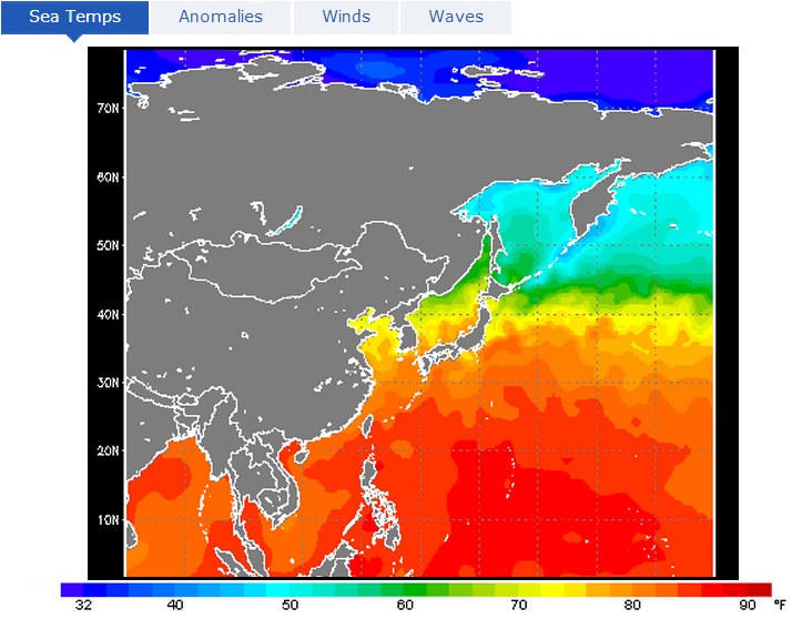
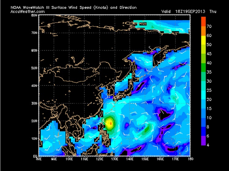
this is really big one friend..check this :
this is the wave meter..
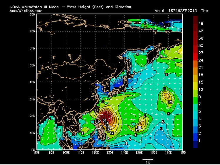
and the wind is Strong!
look at this sea temparature..Perfect for Huricane / typhon..
this is really big one friend..check this :
this is the wave meter..
and the wind is Strong!
edit on 20-9-2013 by cheesy because: (no reason given)
Metaphysique
reply to post by bkaust
certainly doesn't look good for china
as usagi is about to bash it
things could be much worse though
earths-strongest-most-massive-storm-ever
On Oct. 12, 1979, Super Typhoon Tip's central pressure dropped to 870 mb (25.69 inches Hg), the lowest sea-level pressure ever observed on Earth, according to NOAA. Peak wind gusts reached 190 mph (306 kph) while the storm churned over the western Pacific.
Besides having unsurpassed intensity, Super Typhoon Tip is also remembered for its massive size. Tip's diameter of circulation spanned approximately 1,380 miles (2,220 km), setting a record for the largest storm on Earth. The storm's huge diameter was exactly the same as the distance from New York City to Dallas.
ahhh... 20th post finally...
Grat's on the 20 posts, 306km is an absolute monster! The pressure in this one is nowhere close to 870 *yet* Here is a quote that was answered in comparison of Usagi to the huge in size cyclone Yasi we had in Aus a couple of years ago
This was in the comments of a status from the link below.
We just had a look at the Yasi vs Usagi stats. Usagi is currently measuring faster wind speeds, the pressure has dropped to 910, compared to Yasi at 929. Although Yasi measured bigger in width, Usagi is stronger. -Kristal
Link to stormchaser FB where I got initial info
reply to post by cheesy
Thanks for those images Cheesy! The wave heights they seem to be showing are HUGE! I really hope it dies down a little before hitting any land!
Thanks for those images Cheesy! The wave heights they seem to be showing are HUGE! I really hope it dies down a little before hitting any land!
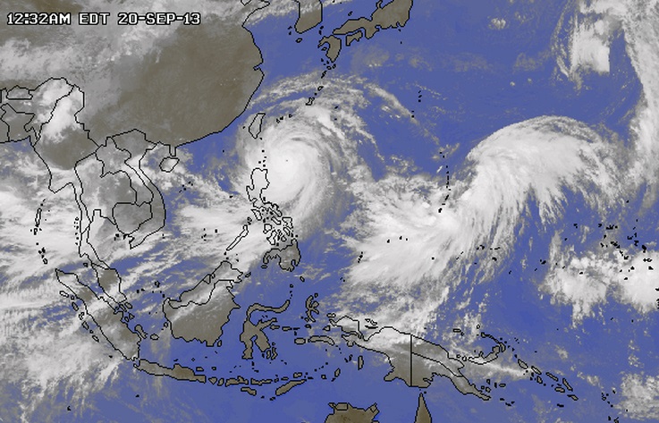
wow this thing developed into a monster since last weekend... I remember there it was mentioned as moderate and nearly stationary on JMA
I thought you guys might like to watch the storm come in.
Here are some live web-cams in Hong Kong. They may not be up long.
Earth Cam-Hong Kong
Here's a link to the Hong Kong Observatory for the most comprehensive coverage of the storm. They also have a weather cam.
Hong Kong Observatory
Here are some live web-cams in Hong Kong. They may not be up long.
Earth Cam-Hong Kong
Here's a link to the Hong Kong Observatory for the most comprehensive coverage of the storm. They also have a weather cam.
Hong Kong Observatory
edit on 9/20/2013 by Neysa because: New link
Nothing to worry about folks. Our shipment of wind from the native Australian Wind Tree must have toppled over in the ocean and been released enmasse
before it reached it's destination of China. Our wind is exported over to China to help clear their air pollution.
Also that wave height is huge... Well I guess it's swell anyways...
48 feet or 14.4 meters...
48 feet or 14.4 meters...
reply to post by bkaust
I will be keeping a close eye on this I have a friend that is in Hong Kong right now. I really hope that it won't be that bad, I told her to be safe and stay indoors.
Thanks for the update
I will be keeping a close eye on this I have a friend that is in Hong Kong right now. I really hope that it won't be that bad, I told her to be safe and stay indoors.
Thanks for the update
I was talking to a friend in Manila this morning, she said they were at signal 4 and it sounded like the roof was going to come off her building. I
can't imagine what it's like on the north-east coast there. I was reading a report earlier that the storm was about 620 miles across. That's
nothing to laugh at.
reply to post by hoagy1199
How scary! Yeah thats what worries me, its so large its bound to hit several areas who won't have homes with secure roofing and things like that, people that live alone the coasts in somewhat temporary/modest homes getting hit the worst
How scary! Yeah thats what worries me, its so large its bound to hit several areas who won't have homes with secure roofing and things like that, people that live alone the coasts in somewhat temporary/modest homes getting hit the worst
Update post on Higgins Storm Chasing website (gathered from links I'll supply)
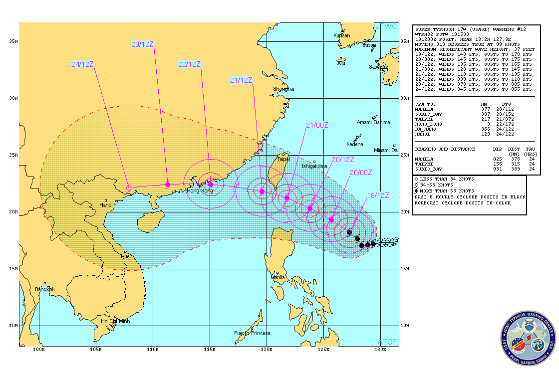
So it looks like the pressure has risen since yesterday and it it now a Cat 4 - looking to downgrade to a cat3 by the time it gets to HK, which is still quite large for such a populous area. I think we will see a fair bit of damage coming out from there by monday morning
"Super Typhoon Usagi Update"
Current intensity Cat 4, 933hpa, wind speeds 222km hr, heading W NW @ 20kmhr towards South China Coast / Hong Kong.
Current forecast track to impact in the vicinity of Hong Kong during Sunday night as a Category 3 with 185km hr winds. Very heavy rainfall leading to flash flooding is expected along with Dangerous ocean storm surge causing land inundation and Destructive winds.
Travel plans in and out of Hong Kong may be affected as weather deteriorates.
Check out this incredible Sat Loop > Sat loop
South China Morning Post > SCMP
JMA Tropical Cyclone Information ( data ) > JMA
So it looks like the pressure has risen since yesterday and it it now a Cat 4 - looking to downgrade to a cat3 by the time it gets to HK, which is still quite large for such a populous area. I think we will see a fair bit of damage coming out from there by monday morning
And after Hong Kong, this monster goes directly over the Macau. These both cities are very coastal and low. Hope it weakens before it hits.
There is very hot weather too, 93°F / 34°C, during the night
There is very hot weather too, 93°F / 34°C, during the night
edit on 21-9-2013 by Thebel because: (no reason given)
Have to keep an eye on this.
I am meeting two colleagues from Hong Kong and India in California, and they are both flying from HK on Sunday so hope they get out ok before it gets too bad. Have to message them both and see if their travel is being affected.
I am meeting two colleagues from Hong Kong and India in California, and they are both flying from HK on Sunday so hope they get out ok before it gets too bad. Have to message them both and see if their travel is being affected.
new topics
-
President BIDEN's FBI Raided Donald Trump's Florida Home for OBAMA-NORTH KOREA Documents.
Political Conspiracies: 3 hours ago -
Maestro Benedetto
Literature: 4 hours ago -
Is AI Better Than the Hollywood Elite?
Movies: 5 hours ago -
Las Vegas UFO Spotting Teen Traumatized by Demon Creature in Backyard
Aliens and UFOs: 8 hours ago -
2024 Pigeon Forge Rod Run - On the Strip (Video made for you)
Automotive Discussion: 9 hours ago -
Gaza Terrorists Attack US Humanitarian Pier During Construction
Middle East Issues: 9 hours ago -
The functionality of boldening and italics is clunky and no post char limit warning?
ATS Freshman's Forum: 10 hours ago -
Meadows, Giuliani Among 11 Indicted in Arizona in Latest 2020 Election Subversion Case
Mainstream News: 11 hours ago -
Massachusetts Drag Queen Leads Young Kids in Free Palestine Chant
Social Issues and Civil Unrest: 11 hours ago
top topics
-
President BIDEN's FBI Raided Donald Trump's Florida Home for OBAMA-NORTH KOREA Documents.
Political Conspiracies: 3 hours ago, 23 flags -
Krystalnacht on today's most elite Universities?
Social Issues and Civil Unrest: 14 hours ago, 9 flags -
University of Texas Instantly Shuts Down Anti Israel Protests
Education and Media: 17 hours ago, 8 flags -
Weinstein's conviction overturned
Mainstream News: 13 hours ago, 8 flags -
Supreme Court Oral Arguments 4.25.2024 - Are PRESIDENTS IMMUNE From Later Being Prosecuted.
Above Politics: 14 hours ago, 8 flags -
Massachusetts Drag Queen Leads Young Kids in Free Palestine Chant
Social Issues and Civil Unrest: 11 hours ago, 7 flags -
Gaza Terrorists Attack US Humanitarian Pier During Construction
Middle East Issues: 9 hours ago, 7 flags -
Las Vegas UFO Spotting Teen Traumatized by Demon Creature in Backyard
Aliens and UFOs: 8 hours ago, 6 flags -
Meadows, Giuliani Among 11 Indicted in Arizona in Latest 2020 Election Subversion Case
Mainstream News: 11 hours ago, 5 flags -
2024 Pigeon Forge Rod Run - On the Strip (Video made for you)
Automotive Discussion: 9 hours ago, 4 flags
active topics
-
President BIDEN's FBI Raided Donald Trump's Florida Home for OBAMA-NORTH KOREA Documents.
Political Conspiracies • 11 • : WeMustCare -
Hate makes for strange bedfellows
US Political Madness • 47 • : 19Bones79 -
-@TH3WH17ERABB17- -Q- ---TIME TO SHOW THE WORLD--- -Part- --44--
Dissecting Disinformation • 689 • : daskakik -
University of Texas Instantly Shuts Down Anti Israel Protests
Education and Media • 265 • : Astrocometus -
Gaza Terrorists Attack US Humanitarian Pier During Construction
Middle East Issues • 27 • : ToneD -
Reason of the Existence
The Gray Area • 21 • : BingoMcGoof -
Supreme Court Oral Arguments 4.25.2024 - Are PRESIDENTS IMMUNE From Later Being Prosecuted.
Above Politics • 85 • : Sookiechacha -
Chris Christie Wishes Death Upon Trump and Ramaswamy
Politicians & People • 24 • : nugget1 -
New whistleblower Jason Sands speaks on Twitter Spaces last night.
Aliens and UFOs • 63 • : pianopraze -
SETI chief says US has no evidence for alien technology. 'And we never have'
Aliens and UFOs • 74 • : Justoneman