It looks like you're using an Ad Blocker.
Please white-list or disable AboveTopSecret.com in your ad-blocking tool.
Thank you.
Some features of ATS will be disabled while you continue to use an ad-blocker.

Noaa: Third Coldest October on record...
page: 1share:
Noaa: Third Coldest October on record...
www.ncdc.noaa.gov
(visit the link for the full news article)
National Overview:
* Temperature Highlights - October
* The average October temperature of 50.8°F was 4.0°F below the 20th Century average and ranked as the 3rd coolest based on preliminary data.
* For the nation as a whole, it was the third coolest October on record. The month was marked by an active weather pattern that reinforced unseasonably cold air behind a series of cold fronts. Temperatures were below normal in eight of the nation's nine climate regions, and of the nine, five were much below normal. Only the Southeast climate region had near normal temperatures for
Related AboveTopSecret.com Discussion Threads:
Statisticians reject global cooling
However in my home state:
# Alaska had its 10th warmest October since records began in 1918, with a temperature 6.3°F (3.5°C) above the 1971–2000 average.
and:
Unusually cold and wet conditions across the middle of the country led to several snowfall records.
and:
Unusually cold and wet conditions across the middle of the country led to several snowfall records.
It's probably too early to make any overall conclusions based on a few month's weather but at least we can put global warming on the shelf for a while
www.ncdc.noaa.gov
(visit the link for the full news article)
Of course no one know what to make of this, least of all Al Gore. But hey, people are waking up to the reality that Obama wasn't the man they thought
he was, so maybe that is causing folks to think "what else is not all it seems to be?" and the "Global Warming is all man's fault" theory is a
prime candidate for that question.
I think we've all known that there is global warming ever since people stood and stared at melting glaciers in north Texas. That was only 10,000
years or so ago but the games have gotten a lot more profitable lately.
The "climate change/global warming" issue is just another big money power play to create a worldwide regulatory agency that will essentially be a cash cow and lucrative political arena.
It's never about the warm fuzzy thing on the billboard. It's always about the cold hard cash behind the scenes.
[edit on 10-11-2009 by badgerprints]
And here in Adelaide, South Australia .... we're currently in the middle of breaking Springtime heat wave records right this moment with 5
consecutive days of temps in excess of 35c ... and we still have two weeks of Spring to go before we hit our summer ! Last summer we hit 46c and broke
records and the way things seem to be getting hotter and hotter here in S.A., I wouldn't be too surprised to see us hit 49c/50c within 5 years.
Mon: 35c
Tue: 37c
Wed: 39c
Thur: 39c (predicted)
Fri: 39c (predicted)
Sat: 33c (predicted)
The worst part is that we're located on the southern part of the continent, 1000's of kms from the equator. In fact, Darwin at the top of the continent and much, much closer to the equator is cooler than here !
Go figure ....
[edit on 10-11-2009 by vita eternus]
[edit on 10-11-2009 by vita eternus]
The likeliness that humans and our waste is the cause of the hole being burnt in the atmosphere is rubbish to me... it may have something to do with
it, but the emissions from cars and the testing and detonation of hundreds of nuclear weapons every year is IMO way more destructive, shooting balls
of fire radiation and pollution into the sky at thousands of degrees Fahrenheit would do the trick if ya ask me.
reply to post by vita eternus
El Niño Arrives; Expected to Persist through Winter 2009-10
Conditions in Australia are forcast to be warmer 2009- 10.
And here in Adelaide, South Australia .... we're currently in the middle of breaking heat wave records right this moment with 5 consecutive days of temps in excess of 35c ... and we still have two weeks of Spring to go
El Niño Arrives; Expected to Persist through Winter 2009-10
El Niño’s negative impacts have included damaging winter storms in California and increased storminess across the southern United States. Some past El Niños also have produced severe flooding and mudslides in Central and South America, and drought in Indonesia.
Conditions in Australia are forcast to be warmer 2009- 10.
People, weather extremes and meteorological anomalies do not equate to climate change over such a short period of time.
The most likely mechanism attributing to these anomalies at the moment, is the changing towards a La Nina type weather pattern
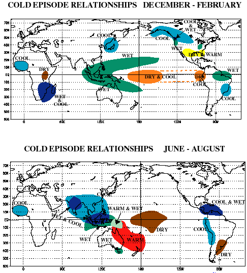
Its not a fully accurate diagram, but it gives a basic picture. And also bear in mind that this is a full blown La Nina, not the exact climate at the moment
The most likely mechanism attributing to these anomalies at the moment, is the changing towards a La Nina type weather pattern
Its not a fully accurate diagram, but it gives a basic picture. And also bear in mind that this is a full blown La Nina, not the exact climate at the moment
Originally posted by plumranch
reply to post by vita eternus
Conditions in Australia are forcast to be warmer 2009- 10.
Instead of using the term "forecast", I can instead almost guarantee that this summer here in South Australia is going to be a horror one based on the number of weather records that we're breaking now on an almost continuous yearly basis. I've lost track of how many weather records we've broken in just the last 5 years alone !
And the El Nino for comparison
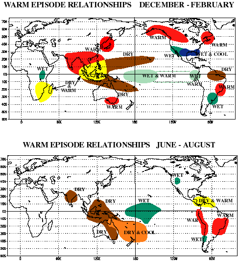
Edit- Oh gawd I got them mixed up, I meant to say its wicthing to an El Nino phase, facepalm
[edit on 10/11/2009 by OzWeatherman]
Edit- Oh gawd I got them mixed up, I meant to say its wicthing to an El Nino phase, facepalm
[edit on 10/11/2009 by OzWeatherman]
reply to post by OzWeatherman
No probs ... we get the idea you're presenting !
Let's just put the error down to the heat up around Woomera, shall we ?
Oh gawd I got them mixed up, I meant to say its wicthing to an El Nino phase
No probs ... we get the idea you're presenting !
Let's just put the error down to the heat up around Woomera, shall we ?
Originally posted by vita eternus
reply to post by OzWeatherman
Oh gawd I got them mixed up, I meant to say its wicthing to an El Nino phase
No probs ... we get the idea you're presenting !
Let's just put the error down to the heat up around Woomera, shall we ?
Lol, yeah already hot 38 here today, 38 yesterday too, 37 the day before and 38 the day before that, lol
Heat stroke does that to ya
It's probably too early to make any overall conclusions based on a few month's weather but at least we can put global warming on the shelf for a while.
Probably not...
April
April 2009 was the fifth warmest April since global surface records began in 1880 for combined global land and ocean surface temperatures. April land surface temperatures were fifth warmest, while ocean surface temperatures tied with 2003 as the fifth warmest in the 130-year record. The year-to-date (January-April) land and ocean combined temperature tied with 2003 as the sixth warmest on record.
May
The combined global land and ocean surface temperature was the fourth warmest on record in May and the fifth warmest on record for boreal spring (March-May). The year-to-date (January-May) land and ocean combined temperature tied with 2003 as the sixth warmest on record.
June
The combined global land and ocean surface temperature was the second warmest on record in June, behind 2005, and tied with 2004 as the fifth warmest on record for the year-to-date (January-June) period. The global ocean had the warmest June on record.
July
The combined global land and ocean surface temperature was the fifth warmest on record in July and tied with 2004 as the sixth warmest on record for the year-to-date (January-July) period. The global land surface tied with 2003 as the ninth warmest July on record, while the global ocean surface had the warmest July on record.
August
The combined global land and ocean surface temperatures for August 2009 ranked as the second warmest August on record since records began in 1880. The combined global land and ocean temperature anomaly was 0.62°C (1.12°F), falling only 0.05°C (0.09°F) short of tying the record set in 1998. Sea surface temperatures (SST) during August 2009 were warmer than average across much of the world's oceans, with cooler-than-average conditions across the higher-latitude southern oceans and the northern parts of the Pacific and Atlantic oceans. The August 2009 worldwide ocean SST ranked as the warmest on record for a third consecutive month—0.57°C (1.03°F) above the 20th century average of 15.6°C (60.1°F). This broke the previous August record set in 1998, 2003, and 2005.
September
The combined global land and ocean surface temperatures for September 2009 ranked as the second warmest September on record since records began in 1880. The combined global land and ocean temperature anomaly was 0.62°C (1.12°F), falling only 0.04°C (0.07°F) short of tying the record set in 2005. Similar to the combined global land and ocean temperatures, the worldwide land surface temperature was the second warmest September on record, behind 2005
That's the global data from NOAA, october is yet to be reported. The data you have is just the US data. Indeed, don't be surprised if a record yearly global temperature is set in the near future.
[edit on 10-11-2009 by melatonin]
Here's a brief summary of what our climatic section (they are gurus at this stuff) has come up with:
From Australian Bureau of Meteorology website
www.bom.gov.au
Ocean surface temperatures in the central equatorial Pacific have warmed further and now exceed levels typical of an El Niño event by their greatest margin of the year. Similarly, the 30-day Southern Oscillation Index has fallen to its lowest value since 2007. Leading climate models suggest tropical ocean temperatures will remain above El Niño thresholds until at least early 2010
The tropical Pacific Ocean sea surface remains warmer than average and exceeds El Niño thresholds in central to eastern regions. The central Pacific has warmed further and now exceeds average values by the largest amount since late 2006.
The sub-surface water of the tropical Pacific has warmed further in central regions over the past two weeks, and now exceed 4°C above normal in some regions.
The SOI has rapidly fallen through October with a current (26 October) 30-day value of approximately −12.
Trade winds have continued to weaken across the tropical Pacific in the last two weeks. Weaker than normal Trade flow is now evident across most of the equatorial Pacific.
Cloudiness near the date line has generally been greater than the long-term mean over past months. However, when compared with other El Niño events, the current trend in cloudiness is weak.
Most leading international climate models surveyed by the Bureau predict the tropical Pacific sea surface temperatures (SST) to remain above El Niño thresholds until at least early 2010.
The Pacific Ocean sea surface remains significantly warmer than the long-term mean over the main El Niño regions. The SST anomaly map for October is available here; the map shows warm anomalies covering most of the tropical Pacific, with anomalies in excess of +1°C evident across much of the central to eastern equatorial Pacific. The central equatorial Pacific has warmed significantly through October, while the western Pacific has cooled. The preliminary monthly NINO indices for October are +0.8°C, +1.0°C and +1.2°C for NINO3, NINO3.4 and NINO4 respectively. When compared with September values, NINO4 has warmed by +0.4°C while NINO3 and NINO3.4 have remained similar in magnitude.
From Australian Bureau of Meteorology website
www.bom.gov.au
reply to post by OzWeatherman
Ok, now you agree with NOAA!
Here are the Pacific temp maps from last week:
[edit on 10/11/09 by plumranch]
Edit- Oh gawd I got them mixed up, I meant to say its wicthing to an El Nino
Ok, now you agree with NOAA!
Here are the Pacific temp maps from last week:
[edit on 10/11/09 by plumranch]
They have also gone for a slightly higher chance of exceeeding average rainfall, but with a very high chance of exceeding mean maximum temperature, so
its not to early to tell now.
The chance that the average November-January maximum temperature will exceed the long-term median maximum temperature, is between 60 to 75% across most of Queensland and northern and eastern NSW. In contrast, the chances of exceeding maximum temperatures are between 35 to 40% for a small region in eastern WA.
The chances of exceeding the median rainfall for November to January are between 25 and 40% over southeast Queensland and the eastern half of NSW (see map). This means that for every ten years with ocean patterns like the current, about six or seven years are expected to be drier than average over these regions, while about three or four years are wetter.
Contrasting this, the chance of wetter than average conditions is between 60 and 65% for western and central parts of the NT and northeast WA.
Across the rest of the country, including Victoria, SA, much of WA and Queensland, the chances of exceeding the median rainfall for October to December are between 40 and 60%, meaning that above average falls are about as equally likely as below average falls in these regions
Sorry, but this is going a bit to far, the chemtrail spraying from alaska to ? in the states is still ongoing, both NOAA and environment canada's
forcasts do not work, the university of Washingtons weather model is also out to lunch, the skies continue to be white even though the satellite pics
say they are blue, i am not mad and neither are you, there is and has been a very big experiment going on in the skies for a number of years now,
perhaps 10 at least since i first noticed it anyway, whether it is weather mods or military crap who knows, all i know is that this is and has been
ongoing and persistant contrails my ass, spin for what ever they are doing, do you..OZ weatherman take us all for complete morons? They the ptb think
that by createing a global shield to reflect sunlight back into space can stop the so called global warming, this is being done by the ptb for profit
even thouigh the ice caps on mars etc are melting also. This is a total scam people by the ptb, scare tactics for profit and no more, next thing we
will hear is that the swine flu is caused by global warming or that the vaccine became toxic because of global warming or that the plants that are our
food dies because of global warming and has nothing to do with montsanto etc. Am i being clear enough now? Choose your own poison, but stay clear of
rupert murdocks. Have a nice night All.
[edit on 10-11-2009 by voodmon]
[edit on 10-11-2009 by voodmon]
[edit on 10-11-2009 by voodmon]
[edit on 10-11-2009 by voodmon]
[edit on 10-11-2009 by voodmon]
[edit on 10-11-2009 by voodmon]
[edit on 10-11-2009 by voodmon]
[edit on 10-11-2009 by voodmon]
[edit on 10-11-2009 by voodmon]
[edit on 10-11-2009 by voodmon]
[edit on 10-11-2009 by voodmon]
[edit on 10-11-2009 by voodmon]
Originally posted by voodmon
do you..OZ weatherman take us all for complete morons?
And it begins
Cant speak about weather without being stalked these days. By the way, the only people I consider morons are the ones that cant debate a topic, instead coming on here targeting other members and posting rubbish thats off topic, and not even providing any sources to back up their point of view.
And FYI voodmon:
And, the infrared satellite image shows high cloud over Washington right now. Maybe you should learn how to actually read one
www.goes.noaa.gov...

new topics
-
Shocking Number of Voters are Open to Committing Election Fraud
US Political Madness: 12 minutes ago -
Gov Kristi Noem Shot and Killed "Less Than Worthless Dog" and a 'Smelly Goat
2024 Elections: 58 minutes ago -
Falkville Robot-Man
Aliens and UFOs: 1 hours ago -
James O’Keefe: I have evidence that exposes the CIA, and it’s on camera.
Whistle Blowers and Leaked Documents: 1 hours ago -
Australian PM says the quiet part out loud - "free speech is a threat to democratic dicourse"...?!
New World Order: 2 hours ago -
Ireland VS Globalists
Social Issues and Civil Unrest: 3 hours ago -
Biden "Happy To Debate Trump"
Mainstream News: 3 hours ago -
RAAF airbase in Roswell, New Mexico is on fire
Aliens and UFOs: 3 hours ago -
What is the white pill?
Philosophy and Metaphysics: 5 hours ago -
Mike Pinder The Moody Blues R.I.P.
Music: 6 hours ago
top topics
-
A Warning to America: 25 Ways the US is Being Destroyed
New World Order: 13 hours ago, 21 flags -
Mike Pinder The Moody Blues R.I.P.
Music: 6 hours ago, 7 flags -
Biden "Happy To Debate Trump"
Mainstream News: 3 hours ago, 7 flags -
James O’Keefe: I have evidence that exposes the CIA, and it’s on camera.
Whistle Blowers and Leaked Documents: 1 hours ago, 5 flags -
What is the white pill?
Philosophy and Metaphysics: 5 hours ago, 5 flags -
Australian PM says the quiet part out loud - "free speech is a threat to democratic dicourse"...?!
New World Order: 2 hours ago, 5 flags -
Ireland VS Globalists
Social Issues and Civil Unrest: 3 hours ago, 4 flags -
RAAF airbase in Roswell, New Mexico is on fire
Aliens and UFOs: 3 hours ago, 4 flags -
Putin, Russia and the Great Architects of the Universe
ATS Skunk Works: 9 hours ago, 3 flags -
Falkville Robot-Man
Aliens and UFOs: 1 hours ago, 1 flags
active topics
-
Shocking Number of Voters are Open to Committing Election Fraud
US Political Madness • 1 • : YourFaceAgain -
Candidate TRUMP Now Has Crazy Judge JUAN MERCHAN After Him - The Stormy Daniels Hush-Money Case.
Political Conspiracies • 804 • : Threadbarer -
-@TH3WH17ERABB17- -Q- ---TIME TO SHOW THE WORLD--- -Part- --44--
Dissecting Disinformation • 700 • : Thoughtful3 -
Gov Kristi Noem Shot and Killed "Less Than Worthless Dog" and a 'Smelly Goat
2024 Elections • 20 • : YourFaceAgain -
Putin, Russia and the Great Architects of the Universe
ATS Skunk Works • 26 • : RussianTroll -
Re-election Tactic - JOE BIDEN Hints He May Put Books in the Homes of Black People.
2024 Elections • 30 • : WeMustCare -
Australian PM says the quiet part out loud - "free speech is a threat to democratic dicourse"...?!
New World Order • 3 • : Athetos -
Biden "Happy To Debate Trump"
Mainstream News • 35 • : WeMustCare -
University of Texas Instantly Shuts Down Anti Israel Protests
Education and Media • 297 • : cherokeetroy -
Ditching physical money
History • 22 • : StudioNada