It looks like you're using an Ad Blocker.
Please white-list or disable AboveTopSecret.com in your ad-blocking tool.
Thank you.
Some features of ATS will be disabled while you continue to use an ad-blocker.

Liquid (water?) flows on Mars Now!!
page: 4share:
Originally posted by odyseusz
Originally posted by ArMaP
These things have been noticed in many Mars photos for some time, but they can analyse it because what we see on those photos is how things are after that something flowed on those places, as far as I know there isn't any photo of it happening (but I don't know if there would be a way of knowing that it was happening at the time).
I have noticed that on some photos it looks like those liquid flows come from the joining between the present day surface and what looks like a different ground layer, like if something was covered by the dust we see today.
I will try to find one of those photos.
PS: Imagir, use only the [img] tags, that way the image will have a scroll-bar and will not mess-up the page layout.
[edit on 31/10/2009 by ArMaP]
Do you all have amnesia? There are several dozens of threads on this forum about that phenomenon and we already saw photos of that process in action. It manifest as a geyser but it's not water probably but methane or something else because in such low atmospheric pressure liquid water
doesn't exist. Ice become directly a vapour and vapour become en ice. There is possibility that liquid water exist on Mars but beneath the surface where the pressure is higher.
Artistic vision of that phenomenon.
And the real photo.
[edit on 31-10-2009 by odyseusz]

Water boils away into vapor with low pressure, and since mean surface level pressure of 600 Pa (0.6 kPa, or 6 millibars, or 0.087 psi), compared to Earth's 101.3 kPa water most definitely will go to gas. I believe that a blowout or massive geyser of water happens and when it bursts and start to go down hill it turns to vapor, but not before enough of the water has laid down enough minerals and traveled far enough to make a landscape change. And it doesn't take into account if the water is "dirty" (meaning has salt or whatever minerals and junk that has dissolved in the water to hinder for awhile the vapor process. But one funny thing is that the deeper you go into the surface of the planet the higher the pressure is. As an example the Hellas Planitia, the massive crater has a pressure of 1.155 kPa which is double the surface level pressure and just 1 percent of earth pressure.
I saw this movie on IFC this past Friday called Stranded: Náufragos, directed by a spanish director and story written by spanish sf author. It stars Vincent Gallo and others and it tells a story of this crew trying to survive on Mars after crashing. I'll post a link, but what hit me the most is that the ancient alien structures and what remained of the alien society built their cliff dwellings in the massive trench on mars and other low areas. When you see the last minutes of the movie when the camera is pulling away from them in the canyon and up the walls of the canyon into orbit gave me pause and to think if you had to survive would you dig your civilization into the caves and deep recesses of the planet in order to maintain air pressure of some sort and maintain atmosphere.
en.wikipedia.org...:_N%C3%A1ufragos
en.wikipedia.org...

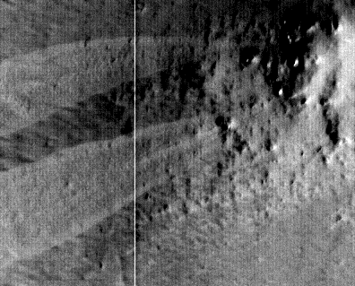
It's starting to seem pretty obvious that mars has alot of water just under the surface in a permafrost or more muddy state. The image from the
Phoenix probe showed water ice just two inches beneath the surface in this region:

A NASA concept of these gullies looks like this:

This image shows a huge permafrost layer and they also stated that the amount of water to cause such a visible outflow was "Each flow that came down each gully may have had a volume of water enough to fill seven community-sized swimming pools or sustain 100 households for a month." link: www.space.com...
I wouldn't be surprised to find areas on mars where the local air pressure may be high enough for liquid water to last for a short time on the surface.
So there seems to be alot of water on mars just under the surface. Future astronauts to mars will have drinking water and the ability to make fuel H20 into hydrogen and oxygen making a manned mission to mars more likely.
A NASA concept of these gullies looks like this:
This image shows a huge permafrost layer and they also stated that the amount of water to cause such a visible outflow was "Each flow that came down each gully may have had a volume of water enough to fill seven community-sized swimming pools or sustain 100 households for a month." link: www.space.com...
I wouldn't be surprised to find areas on mars where the local air pressure may be high enough for liquid water to last for a short time on the surface.
So there seems to be alot of water on mars just under the surface. Future astronauts to mars will have drinking water and the ability to make fuel H20 into hydrogen and oxygen making a manned mission to mars more likely.
The last of the three pics you posted has a shadow of something VERY VERY Tall in it. The photo was taken directly above but the shadow is long and
very thin..Usually something that tall isn't that thin(no support for the height) Unless they have a tree living there with no limbs. I wouldn't
doubt it's some sort of tower.
Originally posted by ArMaP
reply to post by Imagir
Could you tell where did you got that image from? I cannot find it on that photo.
Thanks.
Hi ArMap.
You can find all these images directly in GOOGLE MARS.
Thanks for your research.
Official Data
hirise.lpl.arizona.edu...
Acquisition date: 05 February 2008 Local Mars time: 2:38 PM
Latitude (centered): 11.3 ° Longitude (East): 32.0 °
Range to target site: 277.6 km (173.5 miles) Original image scale range: 27.8 cm/pixel
(with 1 x 1 binning) so objects ~83 cm across are resolved
Map projected scale: 25 cm/pixel and north is up Map projection: EQUIRECTANGULAR
Emission angle: 7.9 ° Phase angle: 46.7 °
Solar incidence angle: 39 °, with the Sun about 51 ° above the horizon Solar longitude: 27.7 °, Northern Spring
For non-map projected products:
North azimuth: 97 ° Sub-solar azimuth: 9.8 °
F O R M A P P R O J E C T E D P R O D U C T S
North azimuth: 270° Sub solar azimuth 184.2°
Originally posted by radarloveguy
fascinating , I can hardly control my excitement .
a distant barren rock has some water .
- note to self - DILLIGAF
...... and there could be some microbes !! ?
- YAWN to SELF -
Wait until the day comes and you find out what is within the Moon -----Man in the Moon lol all you see supplies atmosphere and waterfalls trees and
simply life within.
Earthlike the way this Earth should be until stupid Elitist humans decided to play God here.
Earthlike the way this Earth should be until stupid Elitist humans decided to play God here.
Does anyone ever dare to ask why pictures are still coming out in greyscale? Transmission of infomation from a photograph is distributed by binary
code which forms color, yet the pictures are still grey?
Originally posted by Unleashed68
Does anyone ever dare to ask why pictures are still coming out in greyscale? Transmission of infomation from a photograph is distributed by binary code which forms color, yet the pictures are still grey?
This is another NASA MISTERY......
reply to post by Unleashed68
The HIRISE camera does not produce color images. It produces grayscale images in different wavelengths ("red", "blue-green", and near infrared). By combining the grayscale images in different wavelengths, a false color image can be produced.
hirise.lpl.arizona.edu...
The HIRISE camera does not produce color images. It produces grayscale images in different wavelengths ("red", "blue-green", and near infrared). By combining the grayscale images in different wavelengths, a false color image can be produced.
"False" color means that the color you see in HiRISE images is not the "true" color human eyes would see on Mars. This is because the HiRISE camera views Mars in a different part of the spectrum than human eyes do. Nevertheless, false color imagery is extremely valuable because it illuminates the distinction between different materials and textures.
hirise.lpl.arizona.edu...
reply to post by Imagir
Thanks for that information.
The image below is the original image without any processing (after being converted to the IMG format that NASA and other organisations use from the format used to transmit the data), and you can see several things.
(I should have cropped a bigger image )
And this is the JPEG2000 version, after being processed.
First, the image is smaller than the one you posted, meaning that the image you posted had already some processing done by Google Earth itself.
Second, the image is not that good, as the whole image had very bright and very dark areas, it's difficult to get a good reproduction of all shades of grey.
Considering the above and what we can really see from the photo, it's too small and not in the best light conditions to be really analysed.
As an aside, and to give an idea of scale, that rock (with or without "holes" or "legs" ) is 5 metres long.
Thanks for that information.
The image below is the original image without any processing (after being converted to the IMG format that NASA and other organisations use from the format used to transmit the data), and you can see several things.
(I should have cropped a bigger image )
And this is the JPEG2000 version, after being processed.

First, the image is smaller than the one you posted, meaning that the image you posted had already some processing done by Google Earth itself.
Second, the image is not that good, as the whole image had very bright and very dark areas, it's difficult to get a good reproduction of all shades of grey.
Considering the above and what we can really see from the photo, it's too small and not in the best light conditions to be really analysed.
As an aside, and to give an idea of scale, that rock (with or without "holes" or "legs" ) is 5 metres long.
reply to post by Imagir
It's not really a mystery, it's the best way of doing it.
That way they can have a monochromatic version (usually the red channel) that is good enough to show detail (and usually better than a colour version for that, colour does not help to see detail) and other monochromatic versions for whatever they want, mostly infra-red and ultra-violet, that help seeing specific things.
There's a camera that is analysing clouds on Mars, and for that they also use an orange filter because it's the best to show the clouds.
I know that it may not make much sense to people that do not think about it, but colours as we see them do not help knowing what is seen in the photos.
Originally posted by Imagir
Originally posted by Unleashed68
Does anyone ever dare to ask why pictures are still coming out in greyscale? Transmission of infomation from a photograph is distributed by binary code which forms color, yet the pictures are still grey?
This is another NASA MISTERY......
Actually, ALL digital cameras are basically "color blind" (even the ones owned by consumers like you and me). That is to say, the sensor that picks up the image can only distinguish between shades of gray -- not color.
Whenever you take a picture with your digital camera, the image is projected through various filters that can be picked up by the camera's image sensor as various shades of gray. The computer in your camera reads those shades of gray and "guesses" what the color actually is, then returns an "approximate color" image to you in a second or less.
Therefore, even your personal digital camera is only "approximate true color", just like NASA's color images.
As said by others above, NASA would rather receive the gray scale images as seen through filters of various wavelengths, because these gray scale images contain more information than the colorized image would.
reply to post by havok
It may not be evaporating as much as all that.
I'd say that if it is a sporadic or infrequent welling up of liquid, the nearby dry surface, would wick most of the water into itself, to freeze as ice, just below the surface.
Edited to add that this looks like it's happening all over Mars, not just the area of the photos.
Mars global warming?
[edit on 1/11/2009 by spikey]
reply to post by hoghead cheese
Good points.
The lower a hypothetical alien race went from the surface, the higher the pressure.
So yes i agree, in Mars' current state, it would be the logical direction to build...downward.
I've a feeling that something very nasty happened to the planet Mars at some point in time. What would have been on the surface, would have been exposed to whatever occurred. The survivors would have been those safely ensconced in bunkers...built deep into the crust of mars.
A massive solar flare maybe. Who knows.
Originally posted by ArMaP
reply to post by Imagir
Thanks for that information.
The image below is the original image without any processing (after being converted to the IMG format that NASA and other organisations use from the format used to transmit the data), and you can see several things.
(I should have cropped a bigger image )
And this is the JPEG2000 version, after being processed.
First, the image is smaller than the one you posted, meaning that the image you posted had already some processing done by Google Earth itself.
Second, the image is not that good, as the whole image had very bright and very dark areas, it's difficult to get a good reproduction of all shades of grey.
Considering the above and what we can really see from the photo, it's too small and not in the best light conditions to be really analysed.
As an aside, and to give an idea of scale, that rock (with or without "holes" or "legs" ) is 5 metres long.
Good job!
But however, even in the gray scale and with pixellation, "THE OBJECT" IS STILL THERE!
reply to post by Imagir
Yes, the object is still there, the problem is in trying to understand what the object is.
Yes, the object is still there, the problem is in trying to understand what the object is.
Originally posted by ArMaP
reply to post by Imagir
Yes, the object is still there, the problem is in trying to understand what the object is.
In my opinion surely unnatural: ARTIFACT!
new topics
-
WATCH Two Russian Soldiers Cheat Death Multiple Time While Riding a Motorbike In battleground
World War Three: 49 minutes ago -
CNN John Fritze and The New York Times Can Kiss My Rosey Red
Mainstream News: 2 hours ago -
The Vatican Press Conference to Discuss Apparitions and The Supernatural
Paranormal Studies: 4 hours ago -
Biden claims he brought inflation down from 9 to 3 percent
US Political Madness: 6 hours ago -
The Biden-Hur Tapes
US Political Madness: 7 hours ago -
Weird and unexpected premonitions.
Dreams & Predictions: 8 hours ago -
Pro-Israel billionaires urged New York crackdown on Gaza protests
Social Issues and Civil Unrest: 9 hours ago
top topics
-
RFK Jr Being Left Out of the 2024 POTUS Debate
2024 Elections: 12 hours ago, 11 flags -
Up to 1/3 of illegal immigrants vote: high enough to overturn will of American people
US Political Madness: 17 hours ago, 10 flags -
George Stephanopoulos defiant over Trump's defamation suit: 'I'm not going to be cowed'
US Political Madness: 16 hours ago, 8 flags -
Biden claims he brought inflation down from 9 to 3 percent
US Political Madness: 6 hours ago, 8 flags -
The big spin, how main stream media controlled the narrative.
Propaganda Mill: 14 hours ago, 6 flags -
NATO Military Committee Commander to Hold a News Conference Shortly
Other Current Events: 16 hours ago, 5 flags -
The Biden-Hur Tapes
US Political Madness: 7 hours ago, 5 flags -
Pro-Israel billionaires urged New York crackdown on Gaza protests
Social Issues and Civil Unrest: 9 hours ago, 3 flags -
CNN John Fritze and The New York Times Can Kiss My Rosey Red
Mainstream News: 2 hours ago, 3 flags -
Weird and unexpected premonitions.
Dreams & Predictions: 8 hours ago, 1 flags
active topics
-
Pro-Israel billionaires urged New York crackdown on Gaza protests
Social Issues and Civil Unrest • 3 • : Versioq -
How much did Doctors get bribed
Diseases and Pandemics • 64 • : ksihkahe -
The Vatican Press Conference to Discuss Apparitions and The Supernatural
Paranormal Studies • 1 • : FlyersFan -
Gaza Genocide Real or Propaganda
Middle East Issues • 495 • : Versioq -
Biden accepts Trumps debate challenge
2024 Elections • 125 • : andy06shake -
Israeli strikes on southern Gaza city of Rafah kill 22, mostly children, as US advances aid package
Middle East Issues • 277 • : SchrodingersRat -
WATCH Two Russian Soldiers Cheat Death Multiple Time While Riding a Motorbike In battleground
World War Three • 0 • : DISBOLD -
Mebendazole Video
Medical Issues & Conspiracies • 13 • : NoOneButMeAgain -
Nearly 70% Of Americans Want Talks To End War In Ukraine
Political Issues • 99 • : Versioq -
New Whistleblower: "I worked on a team that dealt with with NHI technology and left in 2018."
Aliens and UFOs • 32 • : Scratchpost