It looks like you're using an Ad Blocker.
Please white-list or disable AboveTopSecret.com in your ad-blocking tool.
Thank you.
Some features of ATS will be disabled while you continue to use an ad-blocker.

Balsamo wrong again - NTSB map rotation
page: 1share:
(sorry for large graphics - I still don't know how to re-size for the page format here)
New piece on my blog:
NTSB Animation Internal Geography, Part 5: A Turn For the Worse
The recent Pilots for 911 Truth AA77 3D Flight Path video is all hypothetical - they ignored the altitude data to put the plane, for argument's sake, at or near the official altitude to see if descent angles matched up (they don't but that's another story). They also ignored for the moment "as a variable" something called “NTSB northern plot data,” "transitioning to" the (altered they say) FDR data path of 71.2 degrees magnetic.
Now some of you will be aware that I started a thread here a few months back looking at the only north-path "data" I knew of - the NTSB animation that shows a final flight path of 90 degrees magnetic - north of the Citgo and Navy Annex just like the PentaCon witnesses said.
Most smart people decided the final overlay map of the Pentagon area was simply rotated 20 degrees counter-clockwise, making the FDR path look like it went that way. There is no other data supporting this path, which is why the Pilots decided the other data was "altered," and only the animation showed the true heading.
John Farmer: "My guess is the simulation was done before the data alteration (that is why in the video it flies north of the Citgo station)." link
Pilots head Rob Balsamo just confirmed to me the extent of this "northern plot data" and that he still believes:
“the map isnt rotated. We are not sure exactly how the NTSB made their plot as they are refusing to answer any questions. […] The grid on the ground correspond to lat/long lines in terms of true north and are accurate at the runway and at the pentagon/map in terms of angles/parallels. The only thing that doesnt correspond is the heading in the heading indicator at end of flight in which John Farmer did a great job locating the alterations.”
Wrong on all fronts. The 70 reading in the animation dial is almost the only right thing for that time frame, matching the "altered" FDR data and the damage path before and inside the building. The ground grid is off in both proportions and scale; instead of rectangles of about 5:7 proportion they are square, about 5.1 by 4.3 minutes each. The orientation of the grid is off, turned about 10 degrees CCW, as if oriented to magnetic north. It clearly does not line up with real world lat/long lines at Dulles and the Pentagon. (these findings explained here)
And most importantly, the final overlay map is rotated, and it's via this rotation that the NTSB "plotted" their "data." This is my graphc explanation. I hope this puts to rest any lingering doubt that the map is indeed rotated.
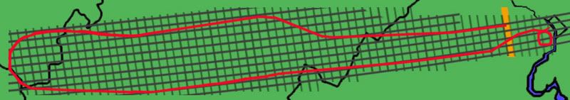
My ginal analysis of the lines seen in the NTSB animation. Effective rotation - 9 degrees CCW - or magnetic as north minus imprecise graphics.
Approaching overlay map crossed by a "latitude" line, marked.
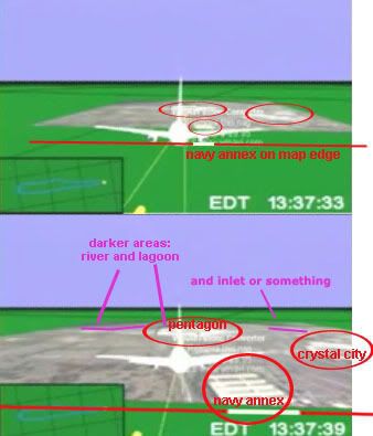 Map analysis - Note the features identified, the angle
of Navy Annex...
Map analysis - Note the features identified, the angle
of Navy Annex...
My best guess for overlay map area (turned 90 degrees) - presuming square
The yellow line is offset from real-world lines by about 7 degrees.
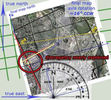
Above map re-rotated to match the yellow line back with the grid. 9 degrees plu 7 = 16 degrees counter-clockwise. Original discrepancy: 20 degrees CCW. This is 80% explained right here, and based on imprecise graphics. Not too bad I'd say.
So, for the record: Other than the map rotated from the rotated grid, which is plain enough to see, there is NO "northern plot data" to "transition" from and there never was.
Thank you.
[edit on 22-9-2007 by Caustic Logic]
New piece on my blog:
NTSB Animation Internal Geography, Part 5: A Turn For the Worse
The recent Pilots for 911 Truth AA77 3D Flight Path video is all hypothetical - they ignored the altitude data to put the plane, for argument's sake, at or near the official altitude to see if descent angles matched up (they don't but that's another story). They also ignored for the moment "as a variable" something called “NTSB northern plot data,” "transitioning to" the (altered they say) FDR data path of 71.2 degrees magnetic.
Now some of you will be aware that I started a thread here a few months back looking at the only north-path "data" I knew of - the NTSB animation that shows a final flight path of 90 degrees magnetic - north of the Citgo and Navy Annex just like the PentaCon witnesses said.
Most smart people decided the final overlay map of the Pentagon area was simply rotated 20 degrees counter-clockwise, making the FDR path look like it went that way. There is no other data supporting this path, which is why the Pilots decided the other data was "altered," and only the animation showed the true heading.
John Farmer: "My guess is the simulation was done before the data alteration (that is why in the video it flies north of the Citgo station)." link
Pilots head Rob Balsamo just confirmed to me the extent of this "northern plot data" and that he still believes:
“the map isnt rotated. We are not sure exactly how the NTSB made their plot as they are refusing to answer any questions. […] The grid on the ground correspond to lat/long lines in terms of true north and are accurate at the runway and at the pentagon/map in terms of angles/parallels. The only thing that doesnt correspond is the heading in the heading indicator at end of flight in which John Farmer did a great job locating the alterations.”
Wrong on all fronts. The 70 reading in the animation dial is almost the only right thing for that time frame, matching the "altered" FDR data and the damage path before and inside the building. The ground grid is off in both proportions and scale; instead of rectangles of about 5:7 proportion they are square, about 5.1 by 4.3 minutes each. The orientation of the grid is off, turned about 10 degrees CCW, as if oriented to magnetic north. It clearly does not line up with real world lat/long lines at Dulles and the Pentagon. (these findings explained here)
And most importantly, the final overlay map is rotated, and it's via this rotation that the NTSB "plotted" their "data." This is my graphc explanation. I hope this puts to rest any lingering doubt that the map is indeed rotated.
My ginal analysis of the lines seen in the NTSB animation. Effective rotation - 9 degrees CCW - or magnetic as north minus imprecise graphics.
Approaching overlay map crossed by a "latitude" line, marked.
My best guess for overlay map area (turned 90 degrees) - presuming square
The yellow line is offset from real-world lines by about 7 degrees.
Above map re-rotated to match the yellow line back with the grid. 9 degrees plu 7 = 16 degrees counter-clockwise. Original discrepancy: 20 degrees CCW. This is 80% explained right here, and based on imprecise graphics. Not too bad I'd say.
So, for the record: Other than the map rotated from the rotated grid, which is plain enough to see, there is NO "northern plot data" to "transition" from and there never was.
Thank you.
[edit on 22-9-2007 by Caustic Logic]
I cannot believe you are using a perspective view to compare to a orthogonal view (if you have any experience in 3D animation, you might
understand..)
Here is a sketch i did awhile ago... (eta: eventually im going to make it more illustrated with 3D and better animation, not just cam movement, but im working on UA93 analysis currently)
Back to the drawing board for you CL.
Lets take a quick rundown of some of CL's past claims...
Animation and Data Not from NTSB and perhaps fabricated by P4T - wrong
Animation is not an official copy, only a working copy - wrong, it was not used for official purpose. Big difference.
Altitude calculations are inaccurate - wrong
Balsamo wrote an article with Fetzer - wrong
Map is rotated - wrong
just off the top of my head... im sure i can find plenty more but im enjoying my weekend.
CL, you must be really getting a taste for your shoe. Let me know if you would like me to send you some jelly spread for the next round..
eta noted above
[edit on 22-9-2007 by johndoex]
Unrelated post to the OP's subject, but there seems to be a bit of confusion about this:
Carry on.
It is also possible to resize images using that code. In the first tag, [ats], make it say this: [ats=100x100], and so the image will now be 100 pixels high by 100 pixels wide. You can of course put any numbers there, but just make sure you keep the ratios accurate, or you will end up with something like this:
GradyPhilpott (Senior Citizen) came up with a good way of keeping image dimensions proportional:
(X/W)H=Y
Where:
X is the desired width
W is the original width
H is the original height
Y is the proportional height.
So say if I had a picture that was 382x641, and I wanted it to be 300 wide instead of 382?
Well, I'd go 300 divided by 382, times 641 equals 503.4
So now I go and put in 300x503, and voila! I have a smaller image that is not warped like the above example! And by the way, round down if given a number such as 203.8. i.e. just ignore the decimals.
Carry on.
reply to post by johndoex
WTR: thanks for the code. Proportions no prob. Will use in the future.
Rob:
I realize the title of this thread is a bit ironic. Guess I was trying to get your attention.
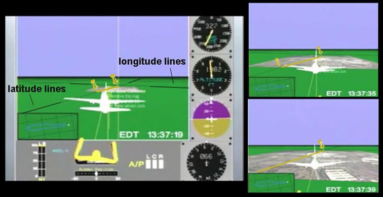
Orthogonal – at right angles. New word of the day, cool… Now, I used the perspective view in the animation to map the lines in the animation because it’s the only view I know. The lines are on the flat-looking ground below, and lat-long lines are stretched basically flat over the Earth’s surface – so yeah, I used a perspective view to determine what the orthogonal grid says. It’s like your flat map angled to look 3D but in reverse. It’s all the same information.
So the fact that a latitude line – marking what seems to be 38° 52' 19" - crosses the Pgon at that spot shows this grid is accurate? If we’re looking at second markers, you could have picked about 20 other such lines that cross the building at different points. You may as well have just drawn an arbitrary line and guessed the number. What makes you think they used the 38° 52' 19" line in the grid? I’d mark only every few minutes, say five or ten, at solid markers with zeros attached, at least in the seconds column. But hey, I’m not the NTSB. By this system, the next marked latitude in the animation grid would be around 38° 49’ and some odd seconds, putting the grid lines roughly 3 minutes apart (I’d said 4.3 above – this is all approximate). The longitude lines are closer to 5 minutes apart. IF these are lat-long lines, they were marked at odd intervals that are disproportionately lumped in perhaps fractions of a minute to come out square instead of the rectangles in real-life.
But they aren’t. That line you traced above is a random latitude line. It crosses the Pentagon East-west. The lines in the animation do not run east west, but are rotated counter-clockwise. I have shown this, and you have not refuted it yet. And then even theses slanted lines cross the Pentagon at an angle indicating a further rotation. I say you’re wrong and you can’t even refute these observations. Just more obfuscation and a list of my previous errors or things you say are errors. This is a shifting of focus.
So the point is, I’ve been wrong in the past for sure. But the question here is am I wrong here? You claim so, that it’s back to the drawing board for me. I disagree.
No jelly thanks. I will taste more leather if anything. So bring it on. We have a 70 mag heading showing on the map as 90, me offering a visual explanation that the map is rotated at least 16 degrees, confirming previous theories that the map was rotated 20 degrees. You claim no rotation anywhere but can only provide a single- irrelevant, non-rotated arbitrary line slapped over and a cauldron of doubt-casting. I thought you had this all figured out that it wasn’t rotated? Where’s the links or graphics? Is that too hard to post on the weekend? I’ll check back Monday.
WTR: thanks for the code. Proportions no prob. Will use in the future.
Rob:
I realize the title of this thread is a bit ironic. Guess I was trying to get your attention.
Orthogonal – at right angles. New word of the day, cool… Now, I used the perspective view in the animation to map the lines in the animation because it’s the only view I know. The lines are on the flat-looking ground below, and lat-long lines are stretched basically flat over the Earth’s surface – so yeah, I used a perspective view to determine what the orthogonal grid says. It’s like your flat map angled to look 3D but in reverse. It’s all the same information.
So the fact that a latitude line – marking what seems to be 38° 52' 19" - crosses the Pgon at that spot shows this grid is accurate? If we’re looking at second markers, you could have picked about 20 other such lines that cross the building at different points. You may as well have just drawn an arbitrary line and guessed the number. What makes you think they used the 38° 52' 19" line in the grid? I’d mark only every few minutes, say five or ten, at solid markers with zeros attached, at least in the seconds column. But hey, I’m not the NTSB. By this system, the next marked latitude in the animation grid would be around 38° 49’ and some odd seconds, putting the grid lines roughly 3 minutes apart (I’d said 4.3 above – this is all approximate). The longitude lines are closer to 5 minutes apart. IF these are lat-long lines, they were marked at odd intervals that are disproportionately lumped in perhaps fractions of a minute to come out square instead of the rectangles in real-life.
But they aren’t. That line you traced above is a random latitude line. It crosses the Pentagon East-west. The lines in the animation do not run east west, but are rotated counter-clockwise. I have shown this, and you have not refuted it yet. And then even theses slanted lines cross the Pentagon at an angle indicating a further rotation. I say you’re wrong and you can’t even refute these observations. Just more obfuscation and a list of my previous errors or things you say are errors. This is a shifting of focus.
So the point is, I’ve been wrong in the past for sure. But the question here is am I wrong here? You claim so, that it’s back to the drawing board for me. I disagree.
No jelly thanks. I will taste more leather if anything. So bring it on. We have a 70 mag heading showing on the map as 90, me offering a visual explanation that the map is rotated at least 16 degrees, confirming previous theories that the map was rotated 20 degrees. You claim no rotation anywhere but can only provide a single- irrelevant, non-rotated arbitrary line slapped over and a cauldron of doubt-casting. I thought you had this all figured out that it wasn’t rotated? Where’s the links or graphics? Is that too hard to post on the weekend? I’ll check back Monday.
Nobody else touching this one, huh? I guess that makes sense.
Okay then, to the extent that past mistakes matter in determining the current case, lemme see just how bad Rob says my track record is and clarify with counter-points.
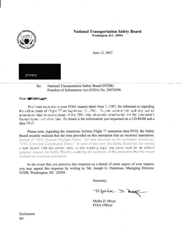
I am no longer claiming this. I had good reason to suspect however, as explained here. Luckily for you guys and unbeknownst to me, the NTSB had just owned up to it in subsequent letters – So I still think the initial doginess and late NTSB course-change (about the ONLY time they’ve moved to answer questions and clear up confusion) is worthy of note for its own reasons, I simply wasn't up-to-date in that case.
I wasn’t even aware of this epic error. Let me clarify then, as the first letter that does mention it says “this working copy was never used for an official purpose.”
They only seem to note the wrong time annotation, and don’t hint at any other errors, like altitude difference or a rotated final map. So all must be fine, right? No, wait…
Your 300-foot correction? I’ve questioned it from a logic standpoint, and ventured guesses why it might be wrong. But I’ve never openly challenged it on technical grounds that I recall. As far as I’m concerned it might be right, by the numbers you were handed anyway. I still don’t get that whole issue…
Yep. Goofed that. Pertly my bias, but I would not have succumbed to that if I hadn’t been tired I guess and failed to double-check.
So is this self-evident to you, or is there a way you can illustrate it to the rest of us? I presume you already have the contrary findings around of course, since you are certain neither the grid nor map are rotated. So where am I wrong?
If you are starting from scratch, here, let me help:
Check my tracking of latitude lines here. Did I track them correctly, as far as number, spacing, parallel and intersect points with the ground track? Did I measure their angle relative to the flight path accurately?
Clues that the grid is square-based and oriented to about magnetic north - all my work shown here.
And then did I place the map edges wrong or something else as seen on this page? It’s all there, waiting to be torn apart.
Nah. A little more leather won't hurt me.
[edit on 24-9-2007 by Caustic Logic]
Okay then, to the extent that past mistakes matter in determining the current case, lemme see just how bad Rob says my track record is and clarify with counter-points.
Lets take a quick rundown of some of CL's past claims...
Animation and Data Not from NTSB and perhaps fabricated by P4T - wrong
I am no longer claiming this. I had good reason to suspect however, as explained here. Luckily for you guys and unbeknownst to me, the NTSB had just owned up to it in subsequent letters – So I still think the initial doginess and late NTSB course-change (about the ONLY time they’ve moved to answer questions and clear up confusion) is worthy of note for its own reasons, I simply wasn't up-to-date in that case.
Animation is not an official copy, only a working copy - wrong, it was not used for official purpose. Big difference.
I wasn’t even aware of this epic error. Let me clarify then, as the first letter that does mention it says “this working copy was never used for an official purpose.”
They only seem to note the wrong time annotation, and don’t hint at any other errors, like altitude difference or a rotated final map. So all must be fine, right? No, wait…
Altitude calculations are inaccurate – wrong
Your 300-foot correction? I’ve questioned it from a logic standpoint, and ventured guesses why it might be wrong. But I’ve never openly challenged it on technical grounds that I recall. As far as I’m concerned it might be right, by the numbers you were handed anyway. I still don’t get that whole issue…
Balsamo wrote an article with Fetzer – wrong
Yep. Goofed that. Pertly my bias, but I would not have succumbed to that if I hadn’t been tired I guess and failed to double-check.
Map is rotated – wrong
So is this self-evident to you, or is there a way you can illustrate it to the rest of us? I presume you already have the contrary findings around of course, since you are certain neither the grid nor map are rotated. So where am I wrong?
If you are starting from scratch, here, let me help:
Check my tracking of latitude lines here. Did I track them correctly, as far as number, spacing, parallel and intersect points with the ground track? Did I measure their angle relative to the flight path accurately?
Clues that the grid is square-based and oriented to about magnetic north - all my work shown here.
And then did I place the map edges wrong or something else as seen on this page? It’s all there, waiting to be torn apart.
just off the top of my head... im sure i can find plenty more but im enjoying my weekend.
CL, you must be really getting a taste for your shoe. Let me know if you would like me to send you some jelly spread for the next round.
Nah. A little more leather won't hurt me.
[edit on 24-9-2007 by Caustic Logic]
Also, on working copy, my letter says the same as above:
not necessarily "unofficial," but a working copy, which implies to me unfinished. It does not bear an NTSB stamp on-screen.
Okay, I looked closer at Rob's graphic from above. We seem to be plotting the approach differently. I mapped it out - again with perspective to detrmine orthographic:
I double-checked the animation trajectory and saw it the same as I did before, showing about 80 deg real, crossing Southgate Road from north to-south as it runs down it. Rob has the line less from north and running all south of the road. I think it likely he's readin it better, somehow finging the actual ground track instead of the flight path shown at plane level. Interestingly, the angle of this line he shows in 76 deg real - exactly sixteen from reality (60 real) as I just found the map to be rotated.
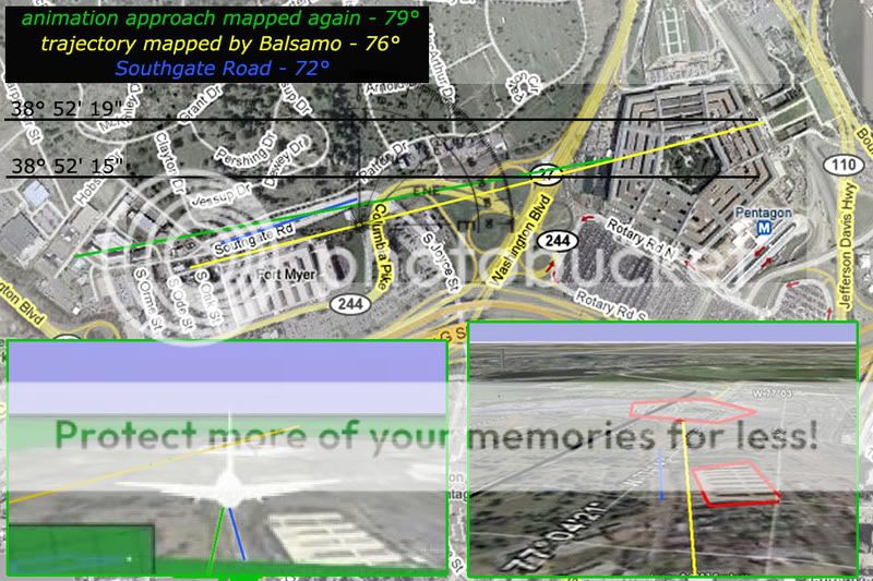
So, unless I'm wrong again, it seems Rob is tracking the flight better than me here, helping me clear up the error that made made my argument work only 80%, giving me a slight boost so it's 100% explained. I see a rotation of 16 deg CCW, his graphics show a flightpath visually altered 16 deg CW from what the FDR says. It lines up. Very interesting.
BTW, I am basically done with FDR issues. I only posted this one because it was already half-done and worth finishing I thought. It's okay to admit once if you're wrong, Rob, as embarrassing as it might be that a dunce like me bested you. Or you could just ignore or dig up more past errors, which I'll take as your way of admitting I got one right but it sure took long enough.
not necessarily "unofficial," but a working copy, which implies to me unfinished. It does not bear an NTSB stamp on-screen.
Okay, I looked closer at Rob's graphic from above. We seem to be plotting the approach differently. I mapped it out - again with perspective to detrmine orthographic:
I double-checked the animation trajectory and saw it the same as I did before, showing about 80 deg real, crossing Southgate Road from north to-south as it runs down it. Rob has the line less from north and running all south of the road. I think it likely he's readin it better, somehow finging the actual ground track instead of the flight path shown at plane level. Interestingly, the angle of this line he shows in 76 deg real - exactly sixteen from reality (60 real) as I just found the map to be rotated.
So, unless I'm wrong again, it seems Rob is tracking the flight better than me here, helping me clear up the error that made made my argument work only 80%, giving me a slight boost so it's 100% explained. I see a rotation of 16 deg CCW, his graphics show a flightpath visually altered 16 deg CW from what the FDR says. It lines up. Very interesting.
BTW, I am basically done with FDR issues. I only posted this one because it was already half-done and worth finishing I thought. It's okay to admit once if you're wrong, Rob, as embarrassing as it might be that a dunce like me bested you. Or you could just ignore or dig up more past errors, which I'll take as your way of admitting I got one right but it sure took long enough.
Originally posted by Caustic Logic
On the contrary. I did not respond because I can't figure out what you are talking about and there have been far too many apologies on your end for things you have misunderstood to try and figure it out only to have to explain where you are wrong. Again.
But I appreciate your effort however misdirected and uninformed it is. Both of us are after the same thing which is the TRUTH.
Some of us have less of an idea about how to go about the task but it no less appreciated.
Thanks for all your work CL.
Nobody else touching this one, huh? I guess that makes sense.
On the contrary. I did not respond because I can't figure out what you are talking about and there have been far too many apologies on your end for things you have misunderstood to try and figure it out only to have to explain where you are wrong. Again.
But I appreciate your effort however misdirected and uninformed it is. Both of us are after the same thing which is the TRUTH.
Some of us have less of an idea about how to go about the task but it no less appreciated.
Thanks for all your work CL.
Originally posted by johnlear
Originally posted by Caustic Logic
Nobody else touching this one, huh? I guess that makes sense.
On the contrary. I did not respond because I can't figure out what you are talking about and there have been far too many apologies on your end for things you have misunderstood to try and figure it out only to have to explain where you are wrong. Again.
But I appreciate your effort however misdirected and uninformed it is. Both of us are after the same thing which is the TRUTH.
Some of us have less of an idea about how to go about the task but it no less appreciated.
Thanks for all your work CL.
Very nice post John. What I'm saying here - and pardon the imprecise language - is I think the animation "lat-long" grid is rotated aout 9 deg CCW from true, and the overlay map's axes rotated 7 deg CCW from those. This 16 deg total rotation comes close to matching the original 20 deg difference in the final approach, and it perfectly matches Rob's line (as seen above).
So... nobody need try and prove me wrong if it's simply too late for me. I understand. And If I am proved wrong, it's basically one last taste of shoe and I'm done. If I'm right, and you guys can confirm, then that's a great opportunity to get some solidarity across a fractious line. CIT doesn't need it, you got the slightly off track angle true and all that's irrelevant anyway due to the altitude issues and general suspiciousness, so I don't think P4T would lose much in dropping "northern plot data," if warranted, and instead wondering why the NTSB turned the map these odd angles to psyche us out or whatever.
CL,
You have been wrong so many times in the past that i decided im not going to let you be a distraction anymore. For crying out loud, i had to show you the pitch and roll angles were recorded in the very csv file you said you had to "guess"! Im tired of holding your hand.
The fact is you are splitting hairs with this thread. Your desperation shows. Your decision to create a hostile subject title to "gain my attention" noted.
I'll let you in on a little secret. It doesnt matter if the map is rotated or not. We are not arguing that fact in the latest 3D animation. We are arguing the fact that the pitch and roll angles do not account for the physical damage based on heading using the "impact hole" as the origin and working backwards. A point with which you agree, yet make excuses (eg, seconds missing).
If you would like to find the errors of your ways regarding missing seconds, speak to an FDR Expert. We spoke to several. We have several interviews with them on our front page. Hint: FDR's cannot be missing anymore than 0.5 seconds of data after power is terminated.
So i suppose your only excuse left would be to theorize power termination several seconds from the wall. Did Hani pull the FDR circuit breaker while flying nap-of-the-earth at over 400 knots in a 757 with Zero time in type yet couldnt control a 172?
Adam, im tired of correcting you. I have way too much work to do to give you lessons. As i said above, we will illustrate the lat/long in a more detailed 3D animation after we get done with UA93 work. The map rotation just isnt that important, especially since we place the aircraft on 61.2 degrees and it still doesnt account for physical damage.
typo
[edit on 24-9-2007 by johndoex]
Larson is clearly in self destruct mode.
He is desperate to discredit PFT and CIT and is frustrated in his lack of progress so he is flailing about wildly in a kamikaze effort to throw himself under the bus in a last ditch attempt to cast doubt on our groundbreaking work.
It's all painfully transparent.
In light of his instant concessions and his failure to make a coherent or relevant point I move for the mods to edit the completely unjustified and totally libelous title of this thread that he ADMITTED was created to get Rob's attention.
Originally posted by johndoex
[...] For crying out loud, i had to show you the pitch and roll angles were recorded in the very csv file you said you had to "guess"! Im tired of holding your hand.
Yeah, you forgot that one on the first list. I admit now I've been over-reaching and I'm sick of it too.
We are arguing the fact that the pitch and roll angles do not account for the physical damage based on heading using the "impact hole" as the origin and working backwards. A point with which you agree, yet make excuses (eg, seconds missing).
If you would like to find the errors of your ways regarding missing seconds, speak to an FDR Expert. We spoke to several. We have several interviews with them on our front page. Hint: FDR's cannot be missing anymore than 0.5 seconds of data after power is terminated.
So yes, IF this less than .5 seconds buffer thing is true, then we have a verifiable data anomaly. It doesn't match the damage at all, or the effectively level approach alleged and shown in that crappy video. Hopefully these experts turn out better than the other one that helped you to see the north path was more real than the other data. I am taking as confirmation of my findings that all you had to say was:
You have been wrong so many times in the past that i decided im not going to let you be a distraction anymore. [...] I'll let you in on a little secret. It doesnt matter if the map is rotated or not. We are not arguing that fact in the latest 3D animation. [...] The map rotation just isnt that important, especially since we place the aircraft on 61.2 degrees and it still doesnt account for physical damage.
In the big picture it's not the biggest deal. You still have the wrong pitch and bank and slightly wrong heading, besides the altitude issues.
The fact is you are splitting hairs with this thread. Your desperation shows. Your decision to create a hostile subject title to "gain my attention" noted.
Yeah I know, I need to chill. In chill mode now. I still believe your overall implications of overflight or whatever it is you don't like to speculate on is either wrong-headed or a tragic misunderstanding between you and your fans. But on specific FDR data issues, I'm done floundering. It's anomolus data.
I stand by this point however or I wouldnt've posted it.
Originally posted by Craig Ranke CIT
Larson is clearly in self destruct mode.
He is desperate to discredit PFT and CIT and is frustrated in his lack of progress so he is flailing about wildly in a kamikaze effort to throw himself under the bus in a last ditch attempt to cast doubt on our groundbreaking work.
It's all painfully transparent.
And what pray tell is the bus that would crush me in this metaphor? I have been trying too hard but actually I'm pretty contented and at peace right now. No more flailing for me and you don't frustrate me like you used to. And Rob, he's fine. I want to send him some pork rinds or something now for wasting so much of his time in the past.
In light of his instant concessions and his failure to make a coherent or relevant point I move for the mods to edit the completely unjustified and totally libelous title of this thread that he ADMITTED was created to get Rob's attention.
That's probably fair. I apologize for that. I'm glad it worked though.
I'll even take a warn if need be.
typos
[edit on 24-9-2007 by Caustic Logic]
If I'm understanding all of this correctly, CL, your claim that the map was rotated: it would have to have been rotated using the exact point of the
impact into the pentagon as a pivot. Otherwise the plane would have completely missed it.
If it just so happened to have been rotated on the point of impact, shouldn't the plane appear to be taking off from a corn field instead of the runway?
If this makes absolutely no sense, ignore it
If it just so happened to have been rotated on the point of impact, shouldn't the plane appear to be taking off from a corn field instead of the runway?
If this makes absolutely no sense, ignore it
reply to post by Angry Danish
It's late but this is worth logging back in for. On the pivot point you are correct. The line extend up to roughly the right point on the building, so that's the pivot it would seem. But this doesn't apply to the whole grid under the flight (black on green), only to the final tack-on map. So this pivot point has no direct effect on the rest of the flight or its origin.
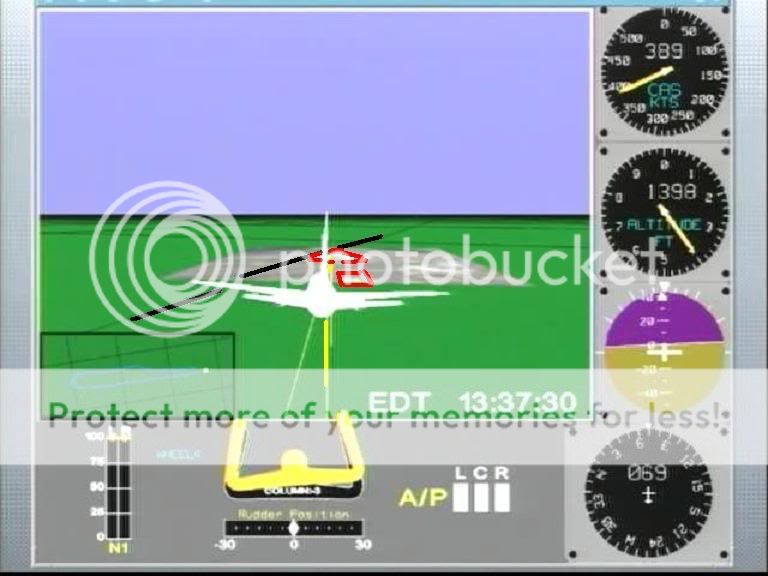
As everyone knows, the degree of rotation gives us an apparent heading difference of 16-20 degrees. But the tack-on map is only rotated (app) 7 degrees from the global animation grid.
And THAT grid seems to be rendered to magnetic north. When the magnetic heading says 270 (due west from MAGNETIC north, as the dial here says) real heading (magnetic corrected - almost exactly 10 degrees less) is 260, or slightly south of west. But this looks remarkably parallel - if I didn't know better I'd say it WAS headed due west.
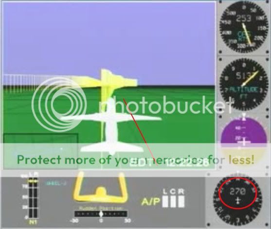
Here it is pointing 180 - due south from magnetic north. The grid seems perfectly lined up, longitudes straight ahead and latitudes perpindicular.
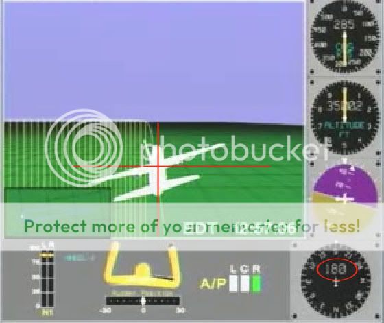
So, I reason, the grid is oriented roughly to magnetic north instead of corrected to true, or geographic north. So it can have no meaningful relation to real world lines. The origin at Dulles has its own skewed relation to these lines, apart from the the final point.
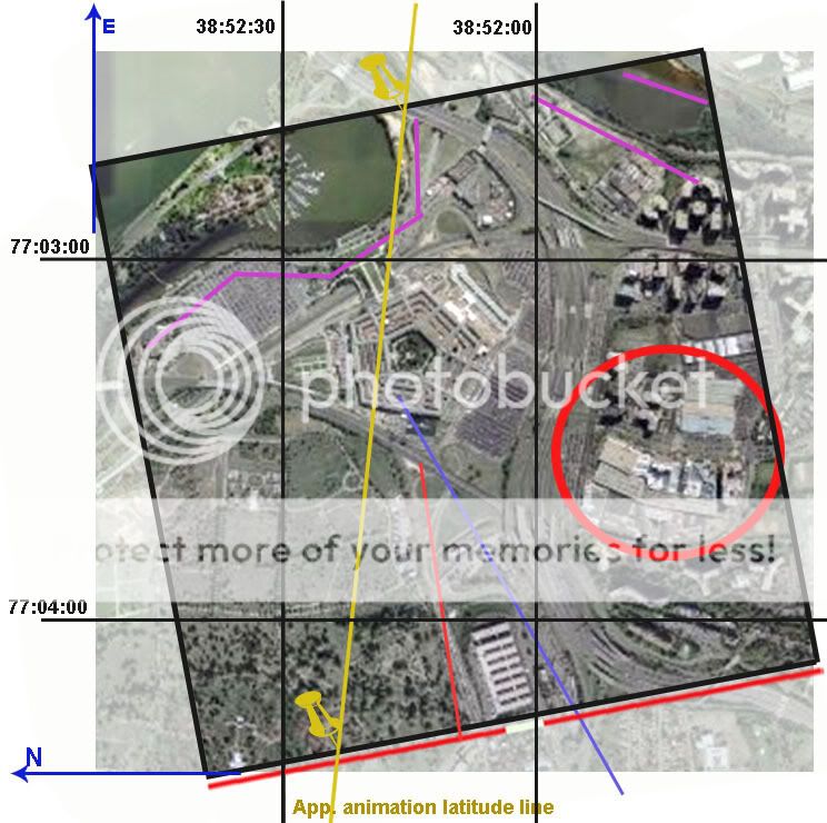
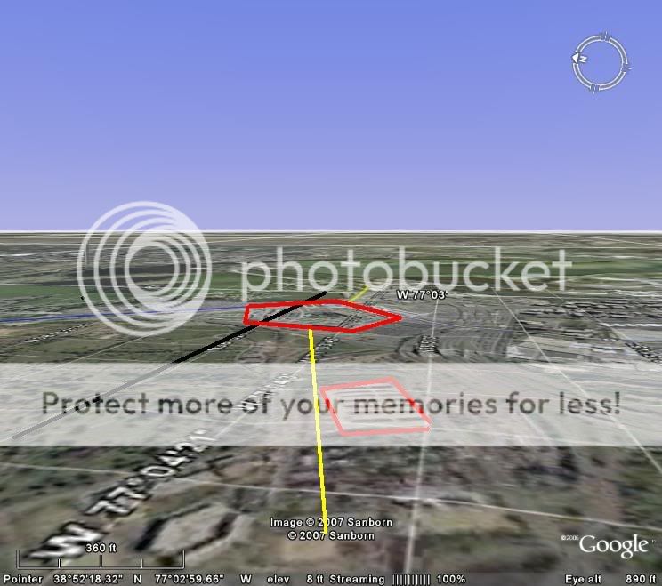
I did a color-code thing to figure this out better, following latitude lines:
The line that crosses the Pentagon tack-on map, which does at that point come out at 38:52:19 I think, I coded aqua blue.
Problem is, the same line is first passed and then parallelled after the south turn over Ohio way south of the Pentagon.
Drawing a line between them, we get something like this compared to the animation flight path:
That ain't east-west. I kept seeing a curve, shown here, but I'm sure they're actually straight, and apparently around 9 degrees rotated CCW from true E-W. Pretty much what the other clues are saying - it thinks the magnetic north pole is the geographic one.
I hope that helps. I know it's a bit confusing.
[edit on 25-9-2007 by Caustic Logic]
[edit on 25-9-2007 by Caustic Logic]
It's late but this is worth logging back in for. On the pivot point you are correct. The line extend up to roughly the right point on the building, so that's the pivot it would seem. But this doesn't apply to the whole grid under the flight (black on green), only to the final tack-on map. So this pivot point has no direct effect on the rest of the flight or its origin.
As everyone knows, the degree of rotation gives us an apparent heading difference of 16-20 degrees. But the tack-on map is only rotated (app) 7 degrees from the global animation grid.
And THAT grid seems to be rendered to magnetic north. When the magnetic heading says 270 (due west from MAGNETIC north, as the dial here says) real heading (magnetic corrected - almost exactly 10 degrees less) is 260, or slightly south of west. But this looks remarkably parallel - if I didn't know better I'd say it WAS headed due west.
Here it is pointing 180 - due south from magnetic north. The grid seems perfectly lined up, longitudes straight ahead and latitudes perpindicular.
So, I reason, the grid is oriented roughly to magnetic north instead of corrected to true, or geographic north. So it can have no meaningful relation to real world lines. The origin at Dulles has its own skewed relation to these lines, apart from the the final point.
I did a color-code thing to figure this out better, following latitude lines:
The line that crosses the Pentagon tack-on map, which does at that point come out at 38:52:19 I think, I coded aqua blue.
Problem is, the same line is first passed and then parallelled after the south turn over Ohio way south of the Pentagon.
Drawing a line between them, we get something like this compared to the animation flight path:
That ain't east-west. I kept seeing a curve, shown here, but I'm sure they're actually straight, and apparently around 9 degrees rotated CCW from true E-W. Pretty much what the other clues are saying - it thinks the magnetic north pole is the geographic one.
I hope that helps. I know it's a bit confusing.
[edit on 25-9-2007 by Caustic Logic]
[edit on 25-9-2007 by Caustic Logic]
I remember doing a bunch of calculations and constructions on this a while back and came to the same conclusion - the map grid is oriented to magnetic
north but the overlay of the pentagon is a chunk from a map that was likely (originally) oriented to true-north. They seem to have matched up the
norths, meaning the pentagon map is not oriented correctly with respect to the rest of the environment of the simulation, its true-north pointing at
mag north. The rotation axis of the satellite chunk isn't exactly clear, but restoring it about the center of the map chunk puts everything in line
with the official story.
What still doesn't make sense is that the plane's compass gives it a heading (070) that puts it on the damage path (downed poles, etc) but the erroneously placed map in the animation places the plane where it was seen - north of CITGO. If it was where the compass says it was, then it would have hit the poles, as it was meant to, but it would also have not been seen by the eyewitnesses, where the faulty reconstruction put it. So is there a relationship between a faulty animation reconstruction and the eyewitness testimony that seems to corroborate it? There seems no explanation for it, conspiracy or otherwise. The only thing I can think of is that :
1) The eyewitnesses are correct, the poles were damaged by something else, the FDR data is incorrect.
2) The FDR data is correct, the plane did what it was meant to, the reconstruction overlay was an honest mistake, and the eyewitnesses are disinfo.
Magic bullet theory or what...
[edit on 25-9-2007 by justin-d]
Originally posted by justin-d
I remember doing a bunch of calculations and constructions on this a while back and came to the same conclusion - the map grid is oriented to magnetic north but the overlay of the pentagon is a chunk from a map that was likely oriented to true-north. They seem to have matched up the norths, meaning the pentagon map is not oriented correctly with respect to the rest of the environment of the simulation. The rotation axis of the satellite chunk isn't exactly clear, but restoring it about the center of the map chunk puts everything in line with the official story.
Cool! You can see it too! I could see them doing this - rotating it clockwise about ten degrees to make it line up with both the official story and the other FDR data. Instead it seems they turned it the opposite way so it's even further off from both.
What still doesn't make sense is that the plane's compass gives it a heading (070) that puts it on the damage path (downed poles, etc) but the erroneously placed map in the animation places the plane where it was seen - north of CITGO. If it was where the compass says it was, then it would have hit the poles, as it was meant to, but it would also have not been seen by the eyewitnesses, where the faulty reconstruction put it. So is there a relationship between a faulty animation reconstruction and the eyewitness testimony that seems to corroborate it?
That is the big mystery here, especially considering the timing - that both pieces of evidence emerged late last summer at the same time and were published in videos at the same time early this year, it's all a bit odd. Probaby just a coincidence, of course, the CIT guys don't put any stock in the FDR as support, and that's smart, since its north path is just an illusion as I've shown. As far as I can tell it's a coincidence that this error matches the eyewitness path somewhat.
There seems no explanation for it, conspiracy or otherwise. The only thing I can think of is that :
1) The eyewitnesses are correct, the poles were damaged by something else, the FDR data is incorrect.
To many ifs for me by far
2) The FDR data is correct, the plane did what it was meant to, the reconstruction overlay was an honest mistake, and the eyewitnesses are disinfo.
Magic bullet theory or what...
Maybe that's a bit harsh, but... well, that's a different story entirely.
Originally posted by Caustic Logic
Cool! You can see it too! I could see them doing this - rotating it clockwise about ten degrees to make it line up with both the official story and the other FDR data. Instead it seems they turned it the opposite way so it's even further off from both.
I'm not sure I would ascribe any intent to it - by all measures it only makes sense as an honest mistake. The FDR data on its own flies where the official story says it does and had they oriented the map properly it would have been perfect. I think it was accidental that they either ignored the magnetic bearing correction or corrected in the wrong direction when overlaying the image - likely a non-standard procedure (only useful for "show", really). Whether deliberately faking data or genuinely attempting to reconstruct FDR data they believed was real, it would make sense in either case to get it right.
The FDR was controlled, vetted, and provided for by the perpetrators.
This is a FACT that anyone who believes 9/11 was an inside job would have to agree.
It so happens to contradict the physical damage no matter how you slice it when considering altitude and descent angles.
Period.
End of story.
What's almost comical is how Adam Larson AKA Caustic Logic already bowed down and conceded that this thread was virtually pointless because of this:
And he admited that his libelous title of this thread was unwarranted yet he is using VERY different harsh rhetoric regarding this same issue at the Loose Change Forum
CL had publicly stated on his blog how he recently signed up there under the name "Pentagon Reality Check".
He even said that he "regrets" using that "arrogant" name.
But if you read some of his posts there it's like he is a completely different person.
You see Caustic Logic/Adam Larson/Pentagon Reality Check has refrained from posting at Loose Change Forum until now because now he knows that I no longer can post there nor can Rob from pilots for truth so he is free to spew his nonsense unchallenged.
And even do it with attitude.
At this forum he acts all nice and polite because he is forced to face FACTS but simultaneously at LC he is playing up an arrogant attitude and ignoring the points he has been forced to concede over here.
Which persona is he faking? Caustic Logic or Pentagon Reality Check or both?
This is a FACT that anyone who believes 9/11 was an inside job would have to agree.
It so happens to contradict the physical damage no matter how you slice it when considering altitude and descent angles.
Period.
End of story.
What's almost comical is how Adam Larson AKA Caustic Logic already bowed down and conceded that this thread was virtually pointless because of this:
CIT doesn't need it, you got the slightly off track angle true and all that's irrelevant anyway due to the altitude issues and general suspiciousness, so I don't think P4T would lose much in dropping "northern plot data," if warranted, and instead wondering why the NTSB turned the map these odd angles to psyche us out or whatever.
And he admited that his libelous title of this thread was unwarranted yet he is using VERY different harsh rhetoric regarding this same issue at the Loose Change Forum
CL had publicly stated on his blog how he recently signed up there under the name "Pentagon Reality Check".
He even said that he "regrets" using that "arrogant" name.
I finally joined the Loose Change forum, hoping to take part in some of the brilliant discussions I'd read there in the past. I tried signing up as Caustic Logic, but that account wouldn't work, so I re-signed up as member “Pentagon Reality Check,” an arrogant name I instantly regretted.
frustratingfraud.blogspot.com...
But if you read some of his posts there it's like he is a completely different person.
You see Caustic Logic/Adam Larson/Pentagon Reality Check has refrained from posting at Loose Change Forum until now because now he knows that I no longer can post there nor can Rob from pilots for truth so he is free to spew his nonsense unchallenged.
And even do it with attitude.
At this forum he acts all nice and polite because he is forced to face FACTS but simultaneously at LC he is playing up an arrogant attitude and ignoring the points he has been forced to concede over here.
Which persona is he faking? Caustic Logic or Pentagon Reality Check or both?
Listen to the arrogance Caustic Logic uses at the LC forum where we can't reply when referring to THIS very thread here at ATS:
To which I reply:
Yes we did "touch" it and we have already gotten you to fully concede that your point DOESN'T MATTER!
Rob has already addressed this fully and even created an animation showing the FDR southern path and it is STILL 100% anomalous with the physical damage and the security camera due to descent angles and altitude.

Yet Larson refuses to acknowledge this on his blog or his brand new thread at LCF and is instead pretending like he has discovered some sort of relevant "debunk".
Guess what Adam?
The northern flight path is based off the EYEWITNESSES who were really there.
It has NEVER been based off the government provided FDR which none of us have EVER claimed to support as factual and not manipulated.
Got it?
Balsamo and Lear won't touch it. Rob tried, got his finger burnt. Craig has nothing to offer but rhetoric and insults. Can anyone HERE show me wrong and salvage the FDR's northern path? If not, I expect to see no one argue for it again.
To which I reply:
Yes we did "touch" it and we have already gotten you to fully concede that your point DOESN'T MATTER!
Rob has already addressed this fully and even created an animation showing the FDR southern path and it is STILL 100% anomalous with the physical damage and the security camera due to descent angles and altitude.
Yet Larson refuses to acknowledge this on his blog or his brand new thread at LCF and is instead pretending like he has discovered some sort of relevant "debunk".
Guess what Adam?
The northern flight path is based off the EYEWITNESSES who were really there.
It has NEVER been based off the government provided FDR which none of us have EVER claimed to support as factual and not manipulated.
Got it?
Originally posted by Craig Ranke CIT
What's almost comical is how Adam Larson AKA Caustic Logic already bowed down and conceded that this thread was virtually pointless
So they've made you my assassin, eh? It's NOT pointless. The point is Rob almost certainly knew the "north plot data" didn't exist, or shold have known it anyway, but insisted it was real until it was undeniable. And then just silence with no admission, covered by rips on me for being willing to admit the FEW times I've bee undeniably wrong. That's telling.
It has never been used for much explicitly, of course. Could that be because it was too useful to ignore but too tentative to put much weight on? It's a small part, but a part nonetheless, of the larger puzzle.
And he admited that his libelous title of this thread was unwarranted
Did not. Sorry for any misunderstanding - I conceded the title was personalized to get Rob's attention. Libel:
In English and American law, and systems based on them, libel and slander are two forms of defamation (or defamation of character), which is the tort or delict of making a false statement of fact that injures someone's reputation.
en.wikipedia.org...
Anything false? If not, the only thing damage is that he didn't catch the error himself, or pretended not to. And that's not my fault. I even prodded and got no response, so I expose. The thread and even title are warranted by these facts, but I guess a title change is fair enough. Hasn't happened tho... I guess being a CM doesn't give you asmuch influence as I thought.
yet he is using VERY different harsh rhetoric regarding this same issue at the Loose Change ForumCL had publicly stated on his blog how he recently signed up there under the name "Pentagon Reality Check".
He even said that he "regrets" using that "arrogant" name.
But if you read some of his posts there it's like he is a completely different person.
You see Caustic Logic/Adam Larson/Pentagon Reality Check has refrained from posting at Loose Change Forum until now because now he knows that I no longer can post there nor can Rob from pilots for truth so he is free to spew his nonsense unchallenged.
It's always about you, isn't it? In fact I decided to join for other reasons, reading the old forum threads, and saw you guys had been banned just as I found the new forum and scanned it before signing up. It had been like a week. It's actually a coincidence tho I don't expect you to believe that. I do appreciate and am exploiting the dynamic there, but I half regret you aren't there. I thought you would be when I decided "time to sign up."
And even do it with attitude.
At this forum he acts all nice and polite because he is forced to face FACTS but simultaneously at LC he is playing up an arrogant attitude and ignoring the points he has been forced to concede over here.
Nope. All the same info and beliefs. I'm not sure why I'm more aggro there. It's a different dynamic. It's a bit too easy so far, and I'm just feeling it out. It might be too boring to stay there myself.
Which persona is he faking? Caustic Logic or Pentagon Reality Check or both?
Keep on guessing, man.
BTW: sorry I said "assassin above." That was a bit melodramatic. I should have said "handler."
I doubt he is Caustic Logic/Adam Larson who isn't very bright.
We keep him at bay over at ATS and he usually caves pretty easily.
z9.invisionfree.com...
Has it ever occurred to you that the main reason I "cave" so much is because I don't have THE TIME for your BS?
[edit on 28-9-2007 by Caustic Logic]
[edit on 28-9-2007 by Caustic Logic]
Originally posted by Craig Ranke CIT
Listen to the arrogance Caustic Logic uses at the LC forum where we can't reply when referring to THIS very thread here at ATS:
Balsamo and Lear won't touch it. Rob tried, got his finger burnt. Craig has nothing to offer but rhetoric and insults. Can anyone HERE show me wrong and salvage the FDR's northern path? If not, I expect to see no one argue for it again.
To which I reply:
Yes we did "touch" it and we have already gotten you to fully concede that your point DOESN'T MATTER!
Goddamnit, dude! Do you have to twist every Fin statement I make to make me say what you want people to think I said? Doesn't matter MUCH in and of itself, since you guys were smart enough to not EXPLICITLY tie anything to the FDR's northiness. But Rob loved to show it, and it was useful in promotion of the PentaCon. Your ally SPreston was still trying to argue that the FDR showed a north path just today over at LC.
And go back to Rob's first post here - a sad attempt to send me "bacj to the drawing board" - it failed miserably, which I call a finger burn. I meant no one will touch the argument, which means concession, and distancing, and it's nothing.
I won this round, just admit it please and move on.
Rob has already addressed this fully and even created an animation showing the FDR southern path and it is STILL 100% anomalous with the physical damage and the security camera due to descent angles and altitude.
Yet Larson refuses to acknowledge this on his blog or his brand new thread at LCF and is instead pretending like he has discovered some sort of relevant "debunk".
Oh just chill. Somehow I'm not as excited to post that I can't explain that, because I finally admit I'm no FDR expert. Surprise? The last frame's data has the wrong pitvh and bank, missing seconds is the only thing that could fix that, Rob says impossible, there are others who disagree, I don't feel like researching it, and so I'm not challenging Rob on that point. That's it. I'm not hiding from anything.
Guess what Adam?
The northern flight path is based off the EYEWITNESSES who were really there.
It has NEVER been based off the government provided FDR which none of us have EVER claimed to support as factual and not manipulated.
Got it?
I've been aware of this. Nothing new. So yeah, I "got it." Thanks for using my first name - I'll have to ask if you're talking to ME and want to use my last name, please preface it with Mr.
[edit on 28-9-2007 by Caustic Logic]
new topics
-
BIDEN Admin Begins Planning For January 2025 Transition to a New President - Today is 4.26.2024.
2024 Elections: 2 minutes ago -
Big Storms
Fragile Earth: 1 hours ago -
Where should Trump hold his next rally
2024 Elections: 4 hours ago -
Shocking Number of Voters are Open to Committing Election Fraud
US Political Madness: 4 hours ago -
Gov Kristi Noem Shot and Killed "Less Than Worthless Dog" and a 'Smelly Goat
2024 Elections: 5 hours ago -
Falkville Robot-Man
Aliens and UFOs: 5 hours ago -
James O’Keefe: I have evidence that exposes the CIA, and it’s on camera.
Whistle Blowers and Leaked Documents: 6 hours ago -
Australian PM says the quiet part out loud - "free speech is a threat to democratic dicourse"...?!
New World Order: 7 hours ago -
Ireland VS Globalists
Social Issues and Civil Unrest: 7 hours ago -
Biden "Happy To Debate Trump"
2024 Elections: 8 hours ago
top topics
-
James O’Keefe: I have evidence that exposes the CIA, and it’s on camera.
Whistle Blowers and Leaked Documents: 6 hours ago, 13 flags -
Blast from the past: ATS Review Podcast, 2006: With All Three Amigos
Member PODcasts: 10 hours ago, 13 flags -
Australian PM says the quiet part out loud - "free speech is a threat to democratic dicourse"...?!
New World Order: 7 hours ago, 12 flags -
Biden "Happy To Debate Trump"
2024 Elections: 8 hours ago, 12 flags -
Mike Pinder The Moody Blues R.I.P.
Music: 10 hours ago, 8 flags -
What is the white pill?
Philosophy and Metaphysics: 10 hours ago, 6 flags -
Shocking Number of Voters are Open to Committing Election Fraud
US Political Madness: 4 hours ago, 6 flags -
RAAF airbase in Roswell, New Mexico is on fire
Aliens and UFOs: 8 hours ago, 5 flags -
Ireland VS Globalists
Social Issues and Civil Unrest: 7 hours ago, 5 flags -
Where should Trump hold his next rally
2024 Elections: 4 hours ago, 4 flags
active topics
-
"We're All Hamas" Heard at Columbia University Protests
Social Issues and Civil Unrest • 294 • : TheWoker -
Where should Trump hold his next rally
2024 Elections • 15 • : Zanti Misfit -
BIDEN Admin Begins Planning For January 2025 Transition to a New President - Today is 4.26.2024.
2024 Elections • 0 • : WeMustCare -
Gaza Terrorists Attack US Humanitarian Pier During Construction
Middle East Issues • 89 • : AlongCameaSpider -
Gov Kristi Noem Shot and Killed "Less Than Worthless Dog" and a 'Smelly Goat
2024 Elections • 37 • : AlongCameaSpider -
Post A Funny (T&C Friendly) Pic Part IV: The LOL awakens!
General Chit Chat • 7138 • : baddmove -
Ireland VS Globalists
Social Issues and Civil Unrest • 8 • : nugget1 -
Definitive 9.11 Pentagon EVIDENCE.
9/11 Conspiracies • 428 • : Zanti Misfit -
Falkville Robot-Man
Aliens and UFOs • 6 • : nugget1 -
So this is what Hamas considers 'freedom fighting' ...
War On Terrorism • 267 • : NorthOS