It looks like you're using an Ad Blocker.
Please white-list or disable AboveTopSecret.com in your ad-blocking tool.
Thank you.
Some features of ATS will be disabled while you continue to use an ad-blocker.

Blocking the GPS signel - Cornwell
page: 11
share:
Has any one heard about the jamming of the GPS signal over an area of Cornwall (UK) for a day?
It was a small piece on the local news, was only half listening at the time.
Supposedly it is an exercise to see how Police, Ambulances and Military cope.
I can't find anything on the net at the moment - just really looking for the location and date at the mo.
Is this a first?
Not that I think it is a bad thing, - GPS is great, but knowing how to use a map is better.
I never heard that news, but I'm with you on knowing map use. Technology fails, which means big trouble for those who are involved in life and death
situations like those fellows are.
Never heard that news either, and being able to read a map is very useful if/when the technology fails.
The next generation of GPS satellite is going to have a better anti-jam capability. I think that this feature will only be available to military users though. If you want to know more about this satellite, read here.
The next generation of GPS satellite is going to have a better anti-jam capability. I think that this feature will only be available to military users though. If you want to know more about this satellite, read here.
Originally posted by Now_Then
Has any one heard about the jamming of the GPS signal over an area of Cornwall (UK) for a day?
It was a small piece on the local news, was only half listening at the time.
Supposedly it is an exercise to see how Police, Ambulances and Military cope.
I can't find anything on the net at the moment - just really looking for the location and date at the mo.
Is this a first?
Not that I think it is a bad thing, - GPS is great, but knowing how to use a map is better.
Let's hope this is never done. I'm a geocacher, so that would put a severe crimp in my hobby.
Whats a geocacher? off the top of me head i'd say something like hi tech orientering or something?
Pretty sure it is gonna happen - only for a radius of 10 - 20 km from a certain point in cornwall. As I said before, was doing other things when it came on the local news (either westcountry or spotlight SW). been meaning to carch the later programs but aint managed yet.
Nothing on the net as of this morning - will check again in a bit.
Its only supposed to be a test, but this is the first I have heard of this sort of test. Wonder if the jamming equip might inteffear with things like mobiles or even radio, don't know how close the frequencies are.
Geocaching is like a GPS guided scavenger hunt. One person puts something in a container or something and posts the coordinates. Then another person
tries to find it using those coordinates, and replaces the object with something else. There are many websites dedicated to it.
More info:
here
and
here
If you want to know more, remember, google is your friend!!!
[edit on 4/6/07 by secret titan]
More info:
here
and
here
If you want to know more, remember, google is your friend!!!
[edit on 4/6/07 by secret titan]
This sounds a little bit "corny" (sorry...) to me.
There are so many people relying on accurate GPS signals these days so I doubt that they could jam the GPS signal for an area as large as Cornwall and get away with it. (I've never been there but I guess it's fairly large). There must be at least an airfield in Cornwall? It sounds like a bit of an overkill to jam the GPS signal to find out if the cops can use a compass and a map!
The GPS signal was deliberately "jammed" before the first Gulf War to an accuracy of about 100 meters for consumer receivers if I remember it correctly. But since there was a shortage of military receivers due to the cost of such devices, the US military removed the inaccuracy from the signal and purchased consumer receivers for their troops. Then after the war they were forced by the US Federal Aviation Administration to keep the accuracy of the signal for the civilian aviation.
With the WAAS/EGNOS satellites in operation in America and Europe, a normal €100 GPS receiver will position accurately with a precision of less than 2 meters. That's enough to take the fun out of GeoCaching...
Its gonna happen!
Just seen a short peace again on BBC spotlight (the regional news program).
The MOD warns that PARTS of Cornwall (sorry for the spelling in the title, its wall not well) will be jammed this thurs and fri.
Going to the MOD site for some more info now.
Oh yeah Geocatching sounds like fun, it is Hi Tech orienteering, we used written descriptions and OS grid references. But that was last millennium
Here it is BBC spotlight on blocking GPS
Portreath seems to be the jamming location.
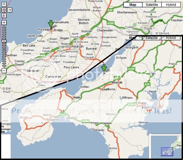
The red ring shows my estimate of the jamming.
[edit on 4/6/2007 by Now_Then]
Portreath seems to be the jamming location.
The effect will extend for a radius of 11 km (7 miles) which would cover Camborne and Redruth.
The red ring shows my estimate of the jamming.
[edit on 4/6/2007 by Now_Then]
Centered on Portreath, eh.
This would be the contaminated site formerly known as Chemical Defence Establishment Nancekuke - the UK's former Chemical Weapon production facility.
During the early-mid 1950s, this facility manufactured the nerve agent Sarin for the UK military. After the UK Government abandoned the production of nerve agents (purely for budgetary reasons), the facility's main claim to fame was as a production centre for the manufacture of CS gas - much of which was produced for the US for use in the Vietnam war.
Upon closure much of the facility's toxic waste was found to have been either discharged to sea, via an undersea pipeline, or buried in one of the many toxic waste dumps on site.
The MOD has in recent years conducted an extensive remediation programme at Nancekuke/Portreath - see links below.
Check out the MOD website for more details of Nancekuke.
www.mod.uk...
www.mod.uk...
www.mod.uk...
zero lift
it is not "to see if police can use a map " - the major point of the exercise is to test military GPS systems in a jamed environment - to calculate
just how effective they are under jamming - and test / devise countermeasures
the @ standard @ resonse would normally be to bomb / attack the jammers - but that is not always practical / possible
as sometimes it is prudent to allow the enemy to keep on jamming - as any attack on the jammer would alert him to potential operations
in this case though police , fire service , ambulance service etc are piggybacking this exersise to ensure they have not become " GPS adicts " unable to rever to manual navigation in an emergency
also as the interference is to be generated by ground based jaming units - in the event of a major incident [ maj or fire , terorist incident or crah ] - it will be possible to ENDEX [ end exercise ] the event in seconds - restoring full GPS operability at the flick of a switch
This is only one form of jamming, i doubt it will be a localised jamming device, more like errors fed into the gps satellites, in which case there is
nothing to blow up!
During the gulf war it was interesting to watch gps get more accurate as the americans had to switch off the "errors" in the system so that they could use off the shelf gps units, as they could not get hold of enough military systems.
During the gulf war it was interesting to watch gps get more accurate as the americans had to switch off the "errors" in the system so that they could use off the shelf gps units, as they could not get hold of enough military systems.
I live in the far west of cornwall - Penzance - and I have to say that we are always seeing military exercises here.
Despite it's size, cornwall does not have a large population, just over half a million with larger concentrations in the east of the county.
en.wikipedia.org...
It also has a few military sites including GCHQ which in turn is part of the NSA network as well as No.405 Signals Unit and No.81 Signals Unit Detachment (West)
www.viewsofcornwall.com...
The relative paucity of population, the big bays and rugged coastline make it ideal for military exercise and where I went to school (St. Just) there were Marines there a lot of the time, scaling cliffs, practising landings etc
So it would not surprise me at all to learn that there had been an exercise of any description - it goes on all the time (although we rarely get specifics) and is so commonplace that it's pretty much part of the background.
Military Gps is totally different from civilian Gps ones much more accurate than the other and jamming is very possible on Gps and very easy to do but
can be countered pretty easy like digging a hole and having the system go straight upwards with out any interferance.
****COMMENTS ARE OPINION ONLY AND BASED OFF COMMON RESOURCES.***
****COMMENTS ARE OPINION ONLY AND BASED OFF COMMON RESOURCES.***
given that advanced gps like egnos also uses ground based repeaters to increase accuracy and system availability in poor weather it wouldn't be that
hard for those stations to send BS out for a bit to confuse any gps in use, and it would be reversible instantly (well, as long as it takes for a gps
to re-aquire sattelites)
Raytheon has some anti-jam GPS work from Autumn 2006 GPS Daily:
Raytheon Awarded Further Jam-Resistant GPS
Contract.
And from the same source more recent (July 2007) developments: Boeing To Submit Proposal For Global Positioning System 3.
Cheers,
Vic
And from the same source more recent (July 2007) developments: Boeing To Submit Proposal For Global Positioning System 3.
Cheers,
Vic
reply to post by budski
405 SU disbanded in 1971, with ther site reverting to the name RAF Hartland Point. Almost all activity ceased in the 1970s, and the site was fully closed in 1987...
405 SU disbanded in 1971, with ther site reverting to the name RAF Hartland Point. Almost all activity ceased in the 1970s, and the site was fully closed in 1987...
new topics
-
CIA is alleged to be operat social media troll frms in Kyiv
ATS Skunk Works: 20 minutes ago -
Rainbow : Stargazer
Music: 57 minutes ago -
I sleep no more.
Philosophy and Metaphysics: 3 hours ago -
Canada caught red-handed manipulating live weather data and make it warmer
Fragile Earth: 3 hours ago -
Why Files Our Alien Overlords | How We Secretly Serve The Tall Whites
Aliens and UFOs: 4 hours ago -
Curse of King Tuts Tomb Solved
Ancient & Lost Civilizations: 6 hours ago -
What allies does Trump have in the world?
ATS Skunk Works: 6 hours ago
top topics
-
BIDEN Admin Begins Planning For January 2025 Transition to a New President - Today is 4.26.2024.
2024 Elections: 15 hours ago, 10 flags -
Canada caught red-handed manipulating live weather data and make it warmer
Fragile Earth: 3 hours ago, 10 flags -
Big Storms
Fragile Earth: 16 hours ago, 9 flags -
Why Files Our Alien Overlords | How We Secretly Serve The Tall Whites
Aliens and UFOs: 4 hours ago, 8 flags -
Curse of King Tuts Tomb Solved
Ancient & Lost Civilizations: 6 hours ago, 6 flags -
What allies does Trump have in the world?
ATS Skunk Works: 6 hours ago, 3 flags -
I sleep no more.
Philosophy and Metaphysics: 3 hours ago, 1 flags -
CIA is alleged to be operat social media troll frms in Kyiv
ATS Skunk Works: 20 minutes ago, 1 flags -
Rainbow : Stargazer
Music: 57 minutes ago, 0 flags
active topics
-
So this is what Hamas considers 'freedom fighting' ...
War On Terrorism • 275 • : YourFaceAgain -
CIA is alleged to be operat social media troll frms in Kyiv
ATS Skunk Works • 1 • : FlyersFan -
Big Storms
Fragile Earth • 18 • : bluesman023 -
Curse of King Tuts Tomb Solved
Ancient & Lost Civilizations • 5 • : diaclonethunder -
University of Texas Instantly Shuts Down Anti Israel Protests
Education and Media • 344 • : DBCowboy -
BIDEN Admin Begins Planning For January 2025 Transition to a New President - Today is 4.26.2024.
2024 Elections • 26 • : bluesman023 -
Canada caught red-handed manipulating live weather data and make it warmer
Fragile Earth • 12 • : YourFaceAgain -
Krystalnacht on today's most elite Universities?
Social Issues and Civil Unrest • 22 • : FlyersFan -
I sleep no more.
Philosophy and Metaphysics • 6 • : AcrobaticDreams1 -
Shocking Number of Voters are Open to Committing Election Fraud
US Political Madness • 8 • : Kaiju666
1