It looks like you're using an Ad Blocker.
Please white-list or disable AboveTopSecret.com in your ad-blocking tool.
Thank you.
Some features of ATS will be disabled while you continue to use an ad-blocker.

Absolute Proof the Earth is Round NOT Flat!
page: 64share:
originally posted by: Itisnowagain
a reply to: Akragon
You might not have noticed that as the camera left the ground.....the ground was already curved at the beginning of the video.........before getting any height.
Doesn't matter...
IF it was a flat plane you'd be able to see it... but all you see is the darkness of space at the edges
originally posted by: Akragon
originally posted by: Itisnowagain
a reply to: Akragon
You might not have noticed that as the camera left the ground.....the ground was already curved at the beginning of the video.........before getting any height.
Doesn't matter...
IF it was a flat plane you'd be able to see it... but all you see is the darkness of space at the edges
Well no if it were flat you would never see the edge because as you get closer to it the gravity would increase towards the center of the flat world. On a flat earth gravity would not be the same everywhere you would be almost weightless on the north pole and be dealing with 3 X earth gravity on Antarctica. It would be terribly uncomfortable being dragged sideways it would feel like climbing a mountain then eventually become impossible for you to move forward
a reply to: dragonridr
Well no because gravity doesn't exist in their fantasy...
The higher you got the farther you'd be able to see... mountians from all over the world would be visable... and eventually you'd see rhe imaginary dome...
But... no one ever sees anything like what you'd logically see on a flat plane
Well no because gravity doesn't exist in their fantasy...
The higher you got the farther you'd be able to see... mountians from all over the world would be visable... and eventually you'd see rhe imaginary dome...
But... no one ever sees anything like what you'd logically see on a flat plane
a reply to: turbonium1
How did I miss this one?
You
This BS was throughly called out. But, man. That is psychopathic rambling there.
What I want to focus on is map projections. Do you realize because the earth is a sphere, it results in maps modeled in 2D not being entirely representative?
Two examples…
Vs.
So. Why would anyone give a flying duck about one more map….
Funny though
This
Is backed by this:
And backed by this.
And backed by this
Not only is flat earth a lie. It’s impractical, and fails on many practical levels. As pointed out. It’s worthless.
How did I miss this one?
You
There's many different models of the flat Earth, almost none are authentic maps of the period, because your ball Earth slime destroyed them all, or most of them?
This BS was throughly called out. But, man. That is psychopathic rambling there.
What I want to focus on is map projections. Do you realize because the earth is a sphere, it results in maps modeled in 2D not being entirely representative?
Top 10 World Map Projections
futuremaps.com...
It may come as a surprise to hear that there is no truly correct way of representing the earth as a flat image.
A world map projection is a visual representation of this challenge using a grid composed of lines of longitude and latitude.
This transference has been subject to interpretation and choice since the earliest days of world mapping.
In no particular order we give you our top 10 world map projections.
Two examples…
Mercator
This projection was developed by Gerardus Mercator back in 1569 for navigational purposes. Its ability to represent lines of constant course from coast to coast made it the perfect map for sailing the seas. Its popularity was so great that it became used as a geographic teaching aid even though the projection grossly distorts countries sizes. This is at its worst the closer you are to the poles. Greenland is 550% too big, it should fit into Africa 14 times!
futuremaps.com...
Vs.
Goode’s Homolosine.
Developed by John Paul Goode in 1925 this projection regains the accuracy of country sizes by adding ‘interruptions’ into the ocean areas, much like an orange peel.
futuremaps.com...
50 Map Projections Types: A Visual Reference Guide [BIG LIST]
gisgeography.com...
So. Why would anyone give a flying duck about one more map….
Funny though
This
It may come as a surprise to hear that there is no truly correct way of representing the earth as a flat image.
futuremaps.com...
Is backed by this:
De Ruijter soon learned that these kinks and deviations were more than local design quirks. They are grid corrections, as he refers to them in a new photographic project: places where North American roads deviate from their otherwise logical grid lines in order to account for the curvature of the Earth.
www.travelandleisure.com...
And backed by this.
A geodetic survey determines the precise position of permanent points on the earth's surface, taking into account the shape, size and curvature of the earth. Geodetic surveying techniques are applied when areas or distances involved are so great that desired accuracy and precision results cannot be obtained by ordinary or plane surveying. Geodetic measurements are now being done with the use of orbiting satellites that are positioned 12,500 miles above the surface of the earth.
agriculture.mo.gov...
And backed by this
Why Are Great Circles the Shortest Flight Path?
gisgeography.com...
Why do you fly over Greenland in an airplane flight?
Or why is it that when you see flight paths on a map they always take a curved route between 2 cities?
It’s because planes travel along the shortest route in a 3-dimensional space.
This route is called a geodesic or great circle route. They are common in navigation, sailing and aviation.
But geodesics can be confusing when you’re looking at a 2-dimensional map as they follow quite the odd flight path. Let’s dig into this concept a bit deeper.
Not only is flat earth a lie. It’s impractical, and fails on many practical levels. As pointed out. It’s worthless.
edit on 19-6-2021 by neutronflux because: Added and fixed
edit on 19-6-2021 by neutronflux because: Fixed
edit
on 19-6-2021 by neutronflux because: Fixed more
edit on 19-6-2021 by neutronflux because: Fixed
originally posted by: Akragon
originally posted by: Itisnowagain
a reply to: Akragon
You might not have noticed that as the camera left the ground.....the ground was already curved at the beginning of the video.........before getting any height.
Doesn't matter...
IF it was a flat plane you'd be able to see it... but all you see is the darkness of space at the edges
itisnowagain, he forgot to tell you that you're 'moving the goalposts', by pointing out the 'curve' shown on the ground!
It's a waste of time trying to show you what's wrong with your argument - and this is yet ANOTHER example of it.
a reply to: turbonium1
i wouldn't expect you to explain it... considering you don't even know what "moving the goal posts" means
you don't have valid explanations for anything you blabber on about
Just adding it to the pile...
i wouldn't expect you to explain it... considering you don't even know what "moving the goal posts" means
you don't have valid explanations for anything you blabber on about
Just adding it to the pile...
a reply to: turbonium1
Far greater minds than mine have tried to convince you that the earth is spherical or an ellipsoid with rather compelling proof and evidence.
But hell, I'll give it another shot.
Please explain this picture of Thorntonbank Wind Farm off the Belgium coast.
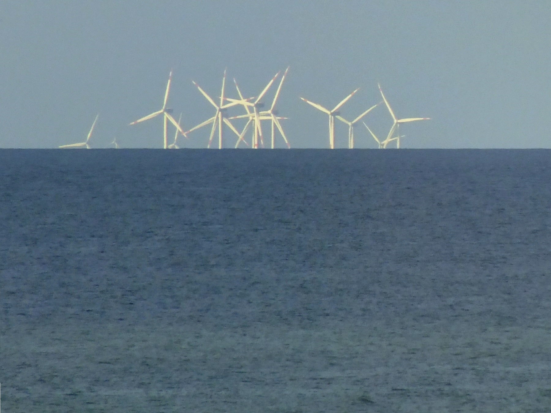
And could you also please explain for me why during a lunar eclipse we don't see a flat shadow of the earth across the moon's surface but in fact see a round shadow?
What are the mechanics of a lunar eclipse according to the flat earth model?
Far greater minds than mine have tried to convince you that the earth is spherical or an ellipsoid with rather compelling proof and evidence.
But hell, I'll give it another shot.
Please explain this picture of Thorntonbank Wind Farm off the Belgium coast.
And could you also please explain for me why during a lunar eclipse we don't see a flat shadow of the earth across the moon's surface but in fact see a round shadow?
What are the mechanics of a lunar eclipse according to the flat earth model?
a reply to: Freeborn
Wow, that is cool I didn't know about this thank you. I looked into it and the windmills are 61.1 m from tip to tip the tower they are on is 184 m above the seafloor and in water ranging from 12 to 27 metres deep. Using these measurements you can take this picture and determine exactly how much of the tower is missing due to earth curvature.
Wow, that is cool I didn't know about this thank you. I looked into it and the windmills are 61.1 m from tip to tip the tower they are on is 184 m above the seafloor and in water ranging from 12 to 27 metres deep. Using these measurements you can take this picture and determine exactly how much of the tower is missing due to earth curvature.
a reply to: dragonridr
Its a great photo and clearly shows the earths curvature.
I'm sure he'll come up with some ridiculous explanation just to confirm his locked in mindset.
I suspect no amount of evidence will ever convince him to change his delusional belief in a flat earth.
I'm also curious as to his explanation as to why the earth doesn't cast a flat shadow in the moon's surface during a lunar eclipse.
a reply to: turbonium1
Give it up man. You just look ridiculous.
You been given photo evidence, experimental evidence, documented video experimental evidence, been show how circular earth effects maps, travel, and land surveying. Flat earth is the impractical lie. Spherical earth is the practical truth.
Nice to see you wrap yourself up in smugness born out of ignorance. That seems sinful. But hey. Your god is a fish bowl god.
Your god’s creative ability who you box in…

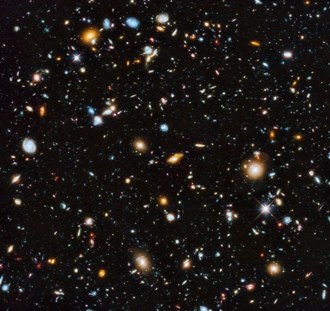
The reality of the vast universe
Give it up man. You just look ridiculous.
You been given photo evidence, experimental evidence, documented video experimental evidence, been show how circular earth effects maps, travel, and land surveying. Flat earth is the impractical lie. Spherical earth is the practical truth.
Nice to see you wrap yourself up in smugness born out of ignorance. That seems sinful. But hey. Your god is a fish bowl god.
Your god’s creative ability who you box in…
The reality of the vast universe
edit on 20-6-2021 by neutronflux because: Fixed
edit on 20-6-2021 by neutronflux because: Tried re
adding pic
edit on 20-6-2021 by neutronflux because: Added more room?
originally posted by: Freeborn
a reply to: turbonium1
Far greater minds than mine have tried to convince you that the earth is spherical or an ellipsoid with rather compelling proof and evidence.
But hell, I'll give it another shot.
Please explain this picture of Thorntonbank Wind Farm off the Belgium coast.
And could you also please explain for me why during a lunar eclipse we don't see a flat shadow of the earth across the moon's surface but in fact see a round shadow?
What are the mechanics of a lunar eclipse according to the flat earth model?
It isn't a shadow, the moon and Sun both circle above Earth, and they cross each other at precise intervals, and 'eclipse' each other, etc.
How would they be the exact same size and shape, if one was 1/4 million miles away, and the other one was 93 million miles away, and they match up perfectly right above the Earth, where we can see both of them 'appear to be' the exact same size and shape, while crossing one another, at regular, exactly timed intervals?
That's the most amazing lucky coinkydink, isn't it? What would be the odds of that happening by purely random chance? Winning the bog lottery 100 times in a row would be more likely than that happening, bud. Use your brain here, because it stinks to high heaven!
a reply to: turbonium1
I see, so you're continuing your particular brand of whining fact avoidance and blatant lying.
I see, so you're continuing your particular brand of whining fact avoidance and blatant lying.
a reply to: turbonium1
You going to keep posting to just prove your ignorance, and keep killing your integrity.
Everything you posted has soundly been refuted and debunked. As citing past posts proves.
Now the crux of the matter.
If the earth is flat, why are these windmills blocked at an increasing amount as the distance increases.
Why are portions physically blocked from view by an increasing amount with distance.
originally posted by: Freeborn
a reply to: turbonium1
Far greater minds than mine have tried to convince you that the earth is spherical or an ellipsoid with rather compelling proof and evidence.
But hell, I'll give it another shot.
Please explain this picture of Thorntonbank Wind Farm off the Belgium coast.
And could you also please explain for me why during a lunar eclipse we don't see a flat shadow of the earth across the moon's surface but in fact see a round shadow?
What are the mechanics of a lunar eclipse according to the flat earth model?
a reply to: turbonium1
That's no answer at all.
How does the earths shadow appear round during an eclipse?
What is a lunar eclipse?
What is a solar eclipse then in this imaginary universe of yours?
You seem to make things up to fit your pre-conceived ideas.
Of course that is after completely ignoring the first question point I raised;
Please explain the photo of Thorntonbank Windmill Farm?
How does the flat earth model explain that?
originally posted by: turbonium1
originally posted by: TerraLiga
The annular eclipse was watched by millions in the northern hemisphere just three days ago. It was predicted decades ago, because the motions of solar and planetary satellites are mathematically predictable to within an error margin of 0.00001% of time and space.
This is the global map of the area of our planet affected by this particular annular eclipse:
c.tadst.com...
Animation courtesy of www.timeanddate.com
As mentioned in the first sentence, this event was witnessed by millions of people at exactly the time and position predicted on this map. Live newscasts, internet streams, photo uploads, social network posts and others all confirm proof.
How is this path possible on a flat plane? Will flat earthers have to convince millions of people that they were wrong about the time and/or position they witnessed the annular eclipse? Or are these millions of people willingly supporting the flat earth conspiracy by falsely reporting what they have seen? Perhaps, the reason this annular eclipse was precisely predicted and shown to follow this path is because the earth is a globe.
Flat earthers are without any doubt THE MOST STUPID beings on this planet.
You believe in tricks, and call others stupid for explaining to you why they are all tricks.... that's the problem.
The cycles of Sun, moon, and stars, were known in ancient times, when we ALREADY had sailed the whole world, and mapped the flat Earth. That's why we knew when the Sun and moon crossed paths with such accuracy back then.
This document notes how the Chinese knew about it in 250 BC, or earlier.
core.ac.uk...
Try to study our REAL past, because what you believe in NOW.... is complete BS.
What IS stupid, is a claim that our Sun and moon, and stars, supposedly millions, and trillions of miles from Earth, supposedly all speeding around 'space', at random, in all directions, would somehow be exactly the SAME, and same positions, and same cycles, to allow these so-called 'experts' to 'predict' where they'll be at all times, today, and THOUSANDS OF YEARS FROM NOW!!
The stars are trillions of miles away, and never change positions, somehow, but since they PREDICT where they'll all be seen, all the time, you believe this is PROOF of Earth being a ball?!!
How absurd can it get?
I'd like to hear your explanation for the path taken for this annular eclipse please. Explain mathematically the path of light taken on a flat plane, as you allege. If you are not capable of this, which is exactly what I suspect from someone who may be a gullible simpleton, then please explain why and how billions of people are 'tricked' every day and for whose benefit.
This is the ONLY way that path can be generated:
upload.wikimedia.org...
The document you have linked to is a PhD dissertation by, now, Professor Cullen. It is a dissertation on ancient Chinese astronomical beliefs, not on current facts. This is not proof of anything. Professor Cullen is not and has never been a 'flat earther'. Not ever.
Ancient Egyptians knew of the procession of the stars - a feat that can only happen by rotation. They made predictions that are true today. Greeks, Persians, Chinese, Assyrians and many others made astronomical predictions that are true today because they are all based on a rotating planet orbiting a star located in a slowly spinning galaxy. Predictably, at known speeds relative to other galaxies and other stars, each rotating in their own time and space. Prove them wrong.
When you leave school I'm hoping that you can be more open to logic and fact. I know that teenagers can be arrogant little turds, but please grow out of it asap, for your own benefit.
a reply to: turbonium1
Now. Explain again why the north star is physically blocked from view in the Southern Hemisphere by the earth’s curvature.
Ooops, looks like I already did.
Now. Explain again why the north star is physically blocked from view in the Southern Hemisphere by the earth’s curvature.
Ooops, looks like I already did.
originally posted by: neutronflux
a reply to: turbonium1
You going to keep posting to just prove your ignorance, and keep killing your integrity.
Everything you posted has soundly been refuted and debunked. As citing past posts proves.
Now the crux of the matter.
If the earth is flat, why are these windmills blocked at an increasing amount as the distance increases.
Why are portions physically blocked from view by an increasing amount with distance.
originally posted by: Freeborn
a reply to: turbonium1
Far greater minds than mine have tried to convince you that the earth is spherical or an ellipsoid with rather compelling proof and evidence.
But hell, I'll give it another shot.
Please explain this picture of Thorntonbank Wind Farm off the Belgium coast.
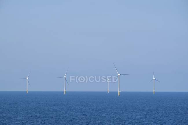
It's easily explained by another viewpoint of them, like this...
I've told you over and over again about how perspective and vanishing point limit our view of distant objects, beyond the horizon, and how to prove it is due to this phenomenon by looking at it from a perpendicular viewpoint.
There's no 'curve' making objects 'vanish' beyond the horizon, it's an illusion caused by perspective and vanishing point of objects in the distance.
Look at the horizon itself, and see how it is completely flat and straight throughout, and proves that your magical 'curve' doesn't exist in any way.
Same as parallel lines or objects don't converge in the distance either - it is simply an ILLUSION, due to perspective and vanishing point. Nothing hard to grasp about this, just use your God given brain for once. Why do you keep ignoring PERPENDICULAR viewpoints of these images you keep posting, as if there's NO OTHER viewpoint to them?
a reply to: turbonium1
Turbo.
It has nothing to do with vanishing point. The earth’s curvature physically blocks the North Star from view in the Southern Hemisphere. If it was vanishing point. A telescope or a pair of binoculars would bring it back into view. But these devices don’t work because the North Star is physically blocked from view.
a reply to: turbonium1
Turbo.
Again. Has nothing to do with vanishing point.
How are the bases of those windmills blocked physically from view at an increasing amount as the go farther behind the horizon.
If it was a flat earth. All the windmills would have their entire lengths visible.
Please use geometry and a mathematical proof to show how and object above a geometric plane would ever be blocked from view by the plane under it.
edit on 25-6-2021 by neutronflux because: Added and fixed
a reply to: turbonium1
You
You mean like climbing a hill, “raising you prospective” to see what is blocked from view by the hill on the other side.
Good job slick. You just proved the earth is curved. And the windmills where blocked from view by the earth’s curvature.
Again…
Please use geometry and a mathematical proof to show how and object above a geometric plane would ever be blocked from view by the plane under it.
You
It's easily explained by another viewpoint of them, like this...
I've told you over and over again about how perspective and vanishing point limit our view of distant objects, beyond the horizon, and how to prove it is due to this phenomenon by looking at it from a perpendicular viewpoint.
You mean like climbing a hill, “raising you prospective” to see what is blocked from view by the hill on the other side.
Good job slick. You just proved the earth is curved. And the windmills where blocked from view by the earth’s curvature.
Again…
Please use geometry and a mathematical proof to show how and object above a geometric plane would ever be blocked from view by the plane under it.
edit on 25-6-2021 by neutronflux because: Added to quote
new topics
-
James O’Keefe: I have evidence that exposes the CIA, and it’s on camera.
Whistle Blowers and Leaked Documents: 19 minutes ago -
Australian PM says the quiet part out loud - "free speech is a threat to democratic dicourse"...?!
New World Order: 1 hours ago -
Ireland VS Globalists
Social Issues and Civil Unrest: 1 hours ago -
Biden "Happy To Debate Trump"
Mainstream News: 2 hours ago -
RAAF airbase in Roswell, New Mexico is on fire
Aliens and UFOs: 2 hours ago -
What is the white pill?
Philosophy and Metaphysics: 3 hours ago -
Mike Pinder The Moody Blues R.I.P.
Music: 4 hours ago -
Putin, Russia and the Great Architects of the Universe
ATS Skunk Works: 7 hours ago -
A Warning to America: 25 Ways the US is Being Destroyed
New World Order: 11 hours ago
top topics
-
President BIDEN's FBI Raided Donald Trump's Florida Home for OBAMA-NORTH KOREA Documents.
Political Conspiracies: 17 hours ago, 35 flags -
A Warning to America: 25 Ways the US is Being Destroyed
New World Order: 11 hours ago, 20 flags -
Mike Pinder The Moody Blues R.I.P.
Music: 4 hours ago, 7 flags -
What is the white pill?
Philosophy and Metaphysics: 3 hours ago, 5 flags -
Biden "Happy To Debate Trump"
Mainstream News: 2 hours ago, 5 flags -
Australian PM says the quiet part out loud - "free speech is a threat to democratic dicourse"...?!
New World Order: 1 hours ago, 4 flags -
RAAF airbase in Roswell, New Mexico is on fire
Aliens and UFOs: 2 hours ago, 4 flags -
Putin, Russia and the Great Architects of the Universe
ATS Skunk Works: 7 hours ago, 3 flags -
Ireland VS Globalists
Social Issues and Civil Unrest: 1 hours ago, 2 flags -
James O’Keefe: I have evidence that exposes the CIA, and it’s on camera.
Whistle Blowers and Leaked Documents: 19 minutes ago, 1 flags
active topics
-
Gaza Terrorists Attack US Humanitarian Pier During Construction
Middle East Issues • 84 • : YourFaceAgain -
Supreme Court Oral Arguments 4.25.2024 - Are PRESIDENTS IMMUNE From Later Being Prosecuted.
Above Politics • 97 • : Sookiechacha -
President BIDEN's FBI Raided Donald Trump's Florida Home for OBAMA-NORTH KOREA Documents.
Political Conspiracies • 33 • : theatreboy -
James O’Keefe: I have evidence that exposes the CIA, and it’s on camera.
Whistle Blowers and Leaked Documents • 3 • : chiefsmom -
University of Texas Instantly Shuts Down Anti Israel Protests
Education and Media • 285 • : Vermilion -
Biden "Happy To Debate Trump"
Mainstream News • 30 • : Lazy88 -
Hate makes for strange bedfellows
US Political Madness • 52 • : YourFaceAgain -
-@TH3WH17ERABB17- -Q- ---TIME TO SHOW THE WORLD--- -Part- --44--
Dissecting Disinformation • 697 • : Thoughtful3 -
So this is what Hamas considers 'freedom fighting' ...
War On Terrorism • 265 • : YourFaceAgain -
Ireland VS Globalists
Social Issues and Civil Unrest • 6 • : TimBurr