It looks like you're using an Ad Blocker.
Please white-list or disable AboveTopSecret.com in your ad-blocking tool.
Thank you.
Some features of ATS will be disabled while you continue to use an ad-blocker.

Hurricane Dorian taking aim at Florida
page: 12share:
a reply to: carewemust
Down to a Cat 2. Still looks impressive on the satellite with all that is going against it. Jogging NE now so it may barely miss SC. Regardless, the eyewall will still impact SC and NC.
It's been spawning a lot of strong tornadoes. Obviously this a will be a major concern throughout the day.
Tornado damage in Morehead City, NC twitter.com...
edit on 5-9-2019 by jrod because: F
a reply to: jrod
I have noticed over the years that tornado spawns tend to accompany weakening. Hurricanes don't like to die.
Not sure if that is a good thing because it means it is weakening, or a bad thing because of the mini-Al-Gores. It just is, I guess.
TheRedneck
I have noticed over the years that tornado spawns tend to accompany weakening. Hurricanes don't like to die.
Not sure if that is a good thing because it means it is weakening, or a bad thing because of the mini-Al-Gores. It just is, I guess.
TheRedneck
a reply to: TheRedneck
Back to 115mph, cat 3, technically a major hurricane as of noon. It does look pretty good on the satellite. The NHC would not quickly upgrade without just cause.
I've had enough of Dorian, it will.be great to retire the storm. Unfortunately he is not done yet.
We Definately don't need man/bear/pigs spinning around causing havoc.
a reply to: jrod
There is a very good reason why I call tornadoes "mini-Al-Gores." They have so much in common. Both are full of hot air, both spin whichever way the wind blows them, and both destroy everything they touch.
TheRedneck
We Definately don't need man/bear/pigs spinning around causing havoc.
There is a very good reason why I call tornadoes "mini-Al-Gores." They have so much in common. Both are full of hot air, both spin whichever way the wind blows them, and both destroy everything they touch.
TheRedneck
Dorian is still maintain as a strong category 2 hurricane, despite land interaction, upwelling, dry air and shear.
Top winds are down to 100mph, pressure remaining steady at 958mb(no sign of weakening) and is moving NE at 13 mph. He remains just offshore and was about 40 miles south of Wilmington, NC as of 10 pm. The center will pass close to the Outer Banks overnight, hurricane conditions are expected there, and tropical storm conditions are possible for the Virginia Beach area.
Dorian is expected to continue to accelerate to the NE and may bring storm conditions to Cape Cod and Eastern Canada. The next full update is at 11pm.
The 11pm forecast discussion key messages from the NHC:
Also, for the first time, dissipation is in the forecast, 120 hours from now.
Dorian is not done yet, but at least his demise is in the forecast.
Key Messages:
1. Regardless of the exact track of Dorian's core, life-threatening
storm surge and dangerous winds are expected along portions of the
North Carolina coast, portions of southeast Virginia and the
southern Chesapeake Bay. Water levels could rise well in advance of
the arrival of strong winds. Residents in these areas should follow
advice given by local emergency officials.
2. Flash flooding is occurring, and will continue to become more
widespread across the eastern Carolinas and far southeast Virginia
overnight. There is a high risk of flash flooding over these
areas, where significant, life-threatening flash flooding is
expected.
Also, for the first time, dissipation is in the forecast, 120 hours from now.
Dorian is not done yet, but at least his demise is in the forecast.
Dorian made landfall at Cape Hatteras, NC. Winds are down to 90mph, while pressure has fallen slightly to 956mb. It's moving NE at 14mph.
A hurricane watch is now in effect for Nova Scotia.
A hurricane watch is now in effect for Nova Scotia.
Its been windy and rainy since last night here in south east Virginia. Near Norfolk.
But its not heavy rain. It is pretty breezy.
I wont be getting any more effects from this storm than what I am experiencing right now.
But its not heavy rain. It is pretty breezy.
I wont be getting any more effects from this storm than what I am experiencing right now.
We're going to drive down to the beach now to see the water.
The Chesapeake bay doesn't normally have much in the way of waves but during a storm it can kick up pretty big ones.
The Chesapeake bay doesn't normally have much in the way of waves but during a storm it can kick up pretty big ones.
Well we are back already. Its cold.
I got out of the car at Fort Monroe. The water looks just like the tv images lol.
It was way up the beach and near the top of the jetty which is six feet above the water at high tide normally.
Lots of whitecaps.
I don't know what the wind speed was but I had to bend over to walk up to the walkway to be able to see the beach.
The rain wasn't heavy but the raindrops were fat and stinging.
edit on 962019 by Sillyolme because: (no reason given)
a reply to: Sillyolme
Dorian is expected to maintain hurricane strength the throughout its extra tropical transition, hence the watch for Nova Scotia. It may even still maintain enough tropical features to still be called a hurricane at that point. Luck for them, it will be moving quickly.
At least the end is near for Dorian. Unfortunately we will likely be watching the tropical wave 94L, as the models are showing it make it all the way across the Atlantic.
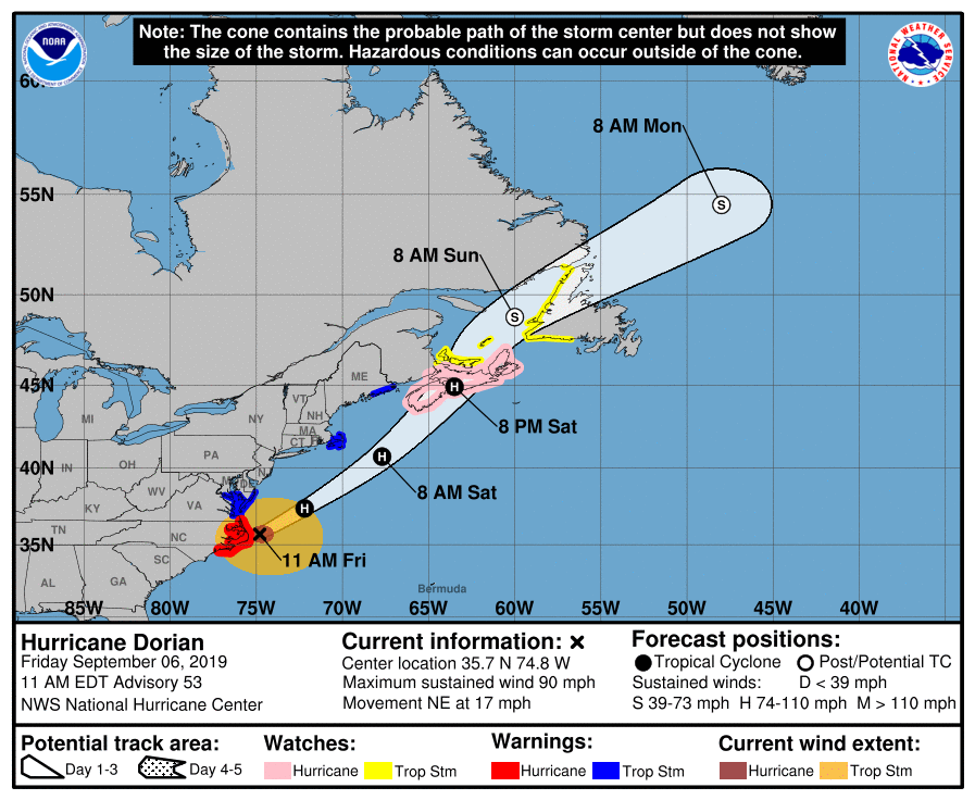
12 pm position:
Location: 35.7°N 74.4°W
Moving: NE at 17 mph
Min pressure: 958 mb
Max sustained: 90 mph
Also note there are tropical storm watches from Cape Cod and Northeast Maine.
Key messages from the 11am advisory:
Location: 35.7°N 74.4°W
Moving: NE at 17 mph
Min pressure: 958 mb
Max sustained: 90 mph
Also note there are tropical storm watches from Cape Cod and Northeast Maine.
Key messages from the 11am advisory:
Dorian is expected to slowly weaken due to increased shear and
entrainment of drier air during the next 24 h or so. After that
time, the hurricane is expected to undergo extratropical
transition and become a large and powerful post-tropical low. It is
unclear whether the transition will be complete before Dorian
reaches Nova Scotia. However, whether Dorian is a hurricane or a
hurricane-force extratropical low, it is expected to bring strong
winds, storm surge, and heavy rains to portions of Nova Scotia and
Newfoundland. The new NHC intensity forecast is little changed from
the previous forecast, and it follows the trend of the intensity
guidance.
Key Messages:
1. Life-threatening storm surge and dangerous winds will continue
along portions of the North Carolina coast, portions of southeast
Virginia and the southern Chesapeake Bay for the next several
hours.
2. Areas of flash flooding, some of which may be significant and
life-threatening, will continue into early afternoon across portions
of northeastern North Carolina into far southeast Virginia.
3. Dangerous storm surge impacts are likely in portions of the Gulf
of St. Lawrence, southwestern Newfoundland and eastern Nova Scotia
this weekend. Hurricane-force winds are also likely in Nova Scotia,
Prince Edward Island and possibly Newfoundland Saturday and Sunday.
Refer to information from the Canadian Hurricane Centre for more
information on these hazards.
edit on 6-9-2019 by jrod because: Add tags
Dorian is expected to hit Nova Scotia as a hurricane later today. Currently Cape Cod is experiencing strong winds from Dorian.
This storm just won't quit...
This storm just won't quit...
a reply to: jrod
Incredible...how it just stops and sits on top of the Bahamas...restarts makes a hard right and barely grazes our coastline...
twitter.com...
Then the skies turn purple in Florida...
Makes me wonder.
Incredible...how it just stops and sits on top of the Bahamas...restarts makes a hard right and barely grazes our coastline...
twitter.com...
Then the skies turn purple in Florida...
Makes me wonder.
originally posted by: Beapilot
a reply to: jrod
Incredible...how it just stops and sits on top of the Bahamas...restarts makes a hard right and barely grazes our coastline...
twitter.com...
Then the skies turn purple in Florida...
Makes me wonder.
I never saw a purple sky in Florida (NSB), and I surfed Wednesday afternoon once the storm had moved north. The sky was a beautiful glowing golden color though. Quite a bit different color than usual sunsets around here.
Not sure if it has to do with weather anomoly, or could be HAARP/Skunk works/govt secret weather manipulation system steering the storm making the strange coloring. Who knows anymore?
Dorian is a post tropical/extra tropical low that still has hurricane winds.
Nova Scotia has already hit, now Western New Foundland is getting hurricane conditions.
The storm is moving fast, NNE at 26mph with top winds of 80 mph.
The NHC has continued to issue advisories, even though Dorian is no longer a tropical system because it is a threat to land.
Nova Scotia has already hit, now Western New Foundland is getting hurricane conditions.
The storm is moving fast, NNE at 26mph with top winds of 80 mph.
The NHC has continued to issue advisories, even though Dorian is no longer a tropical system because it is a threat to land.
new topics
-
A Warning to America: 25 Ways the US is Being Destroyed
New World Order: 4 hours ago -
President BIDEN's FBI Raided Donald Trump's Florida Home for OBAMA-NORTH KOREA Documents.
Political Conspiracies: 9 hours ago -
Maestro Benedetto
Literature: 11 hours ago -
Is AI Better Than the Hollywood Elite?
Movies: 11 hours ago
top topics
-
President BIDEN's FBI Raided Donald Trump's Florida Home for OBAMA-NORTH KOREA Documents.
Political Conspiracies: 9 hours ago, 28 flags -
Gaza Terrorists Attack US Humanitarian Pier During Construction
Middle East Issues: 16 hours ago, 8 flags -
A Warning to America: 25 Ways the US is Being Destroyed
New World Order: 4 hours ago, 8 flags -
Las Vegas UFO Spotting Teen Traumatized by Demon Creature in Backyard
Aliens and UFOs: 15 hours ago, 6 flags -
2024 Pigeon Forge Rod Run - On the Strip (Video made for you)
Automotive Discussion: 15 hours ago, 4 flags -
Is AI Better Than the Hollywood Elite?
Movies: 11 hours ago, 3 flags -
The functionality of boldening and italics is clunky and no post char limit warning?
ATS Freshman's Forum: 17 hours ago, 1 flags -
Maestro Benedetto
Literature: 11 hours ago, 1 flags
active topics
-
A Warning to America: 25 Ways the US is Being Destroyed
New World Order • 6 • : theatreboy -
Supreme Court to decide if states can control fate of social media
Education and Media • 14 • : SMMPanelPro -
Gaza Terrorists Attack US Humanitarian Pier During Construction
Middle East Issues • 35 • : Lazy88 -
Definitive 9.11 Pentagon EVIDENCE.
9/11 Conspiracies • 426 • : Lazy88 -
Alternate Electors vs Fake Electors - What is the Difference.
2024 Elections • 117 • : ADVISOR -
-@TH3WH17ERABB17- -Q- ---TIME TO SHOW THE WORLD--- -Part- --44--
Dissecting Disinformation • 691 • : Imbackbaby -
Victoria government has cancelled the commmonwealth games, no money.
Regional Politics • 3 • : nazaretalazareta -
President BIDEN's FBI Raided Donald Trump's Florida Home for OBAMA-NORTH KOREA Documents.
Political Conspiracies • 19 • : ADVISOR -
When an Angel gets his or her wings
Religion, Faith, And Theology • 22 • : AcrobaticDreams1 -
King Charles 111 Diagnosed with Cancer
Mainstream News • 321 • : FlyersFan