It looks like you're using an Ad Blocker.
Please white-list or disable AboveTopSecret.com in your ad-blocking tool.
Thank you.
Some features of ATS will be disabled while you continue to use an ad-blocker.

Alaska's Wildfire Season Is Exploding, Spreading Smoke Across the State
page: 1share:
The title is from the article about my state, about me being in it, and yes, about how bad it is. But I am not complaining!
It is not like Greece 2018 where 102 people died. People fled into the ocean as wind whipped heat scorched their backs until they dove under water.
But first, the main story.
gizmodo.com, Alaska's Wildfire Season Is Exploding, Spreading Smoke Across the State.
I am in Anchorage. I have a co-worker with asthma nearly go into fits last week. It is worse this week. Right now, there is a layer of clouds that has mixed with the smoke making everything grayish. It smells. You can see it when you look in the distance. And even a moderately healthy individual, me, is having to cope. Police, bus drivers, old folks, and even some middle aged, are donning face masks. My nose is running with snot trying to keep me from breathing it in... indoors! And I have a spit cup as I had really bad cold a few years ago and my body has "nope, ain't going to happen" to any post nasal drip. Combined with the heat, I was dry heaving the other day.
But we are not the only state or nation dealing wildfires! Mexico was on fire last month. Canada has smoke blowing into the US from the north. Africa and Europe have had a wave of wildfires pass. New Mexico had a satellite photo up at some news site showing the state blanketed in smoke.
NASA Earth Obervatory (homepage)
Where ever you happen to be, feel free to chime in! Would love to hear from others here in AK and Europe about what you have been through. Does England have a wildfire season? IDK, why I am asking. Any other experiences/advice for other members?
Like: Keep a defendable space around your property. 50 feet is typical but more if you can.
And most importantly, stay safe!
Btw, going mobile and will be out of touch for a bit!
It is not like Greece 2018 where 102 people died. People fled into the ocean as wind whipped heat scorched their backs until they dove under water.
But first, the main story.
Historic, record-breaking heat isn’t the only environmental malaise that’s gripped Alaska this summer. So has wildfire smoke.
An incredible satellite image taken on July 8 shows smoke spreading far and wide across Alaska as a spate of hot, dry weather causes the state’s wildfire season to kick into high gear. Dense smoke advisories and red flag fire warnings are currently in effect across interior Alaska and on the Kenai Peninsula, while concentrations of particulate matter, which can lodge in the lungs and cause breathing problems, have surged to dangerous levels around Fairbanks and surrounding communities. Alaska Center for Climate Assessment and Policy climatologist Rick Thoman, who’s based in Fairbanks, said that visibility is currently about a mile and described the air quality as “terrible,” noting that one air quality station notched a particulate matter reading of over 700 this morning. Levels over 250 are considered hazardous to human health.
The 41 large fires the National Interagency Fire Center is currently tracking in Alaska include the Swan Lake fire south of Anchorage, which has topped 100,000 acres in size but is getting closer to containment, and the Hess Creek fire northwest of Fairbanks, now the largest fire in the U.S. at over 149,000 acres. Sparked by lightning on June 21, the fire has expanded dramatically on the heels of the last week’s hot weather and remains entirely out of control.
These fires and many others are being fueled by a week of record-shattering heat, which, after the second-warmest June in Alaska’s history, has turned much of interior and southern part of the state into a tinderbox.
gizmodo.com, Alaska's Wildfire Season Is Exploding, Spreading Smoke Across the State.
I am in Anchorage. I have a co-worker with asthma nearly go into fits last week. It is worse this week. Right now, there is a layer of clouds that has mixed with the smoke making everything grayish. It smells. You can see it when you look in the distance. And even a moderately healthy individual, me, is having to cope. Police, bus drivers, old folks, and even some middle aged, are donning face masks. My nose is running with snot trying to keep me from breathing it in... indoors! And I have a spit cup as I had really bad cold a few years ago and my body has "nope, ain't going to happen" to any post nasal drip. Combined with the heat, I was dry heaving the other day.
But we are not the only state or nation dealing wildfires! Mexico was on fire last month. Canada has smoke blowing into the US from the north. Africa and Europe have had a wave of wildfires pass. New Mexico had a satellite photo up at some news site showing the state blanketed in smoke.
Some of the global patterns that appear in the fire maps over time are the result of natural cycles of rainfall, dryness, and lightning. For example, naturally occurring fires are common in the boreal forests of Canada in the summer. In other parts of the world, the patterns are the result of human activity. For example, the intense burning in the heart of South America from August-October is a result of human-triggered fires, both intentional and accidental, in the Amazon Rainforest and the Cerrado (a grassland/savanna ecosystem) to the south. Across Africa, a band of widespread agricultural burning sweeps north to south over the continent as the dry season progresses each year. Agricultural burning occurs in late winter and early spring each year across Southeast Asia.
NASA Earth Obervatory (homepage)
Where ever you happen to be, feel free to chime in! Would love to hear from others here in AK and Europe about what you have been through. Does England have a wildfire season? IDK, why I am asking. Any other experiences/advice for other members?
Like: Keep a defendable space around your property. 50 feet is typical but more if you can.
And most importantly, stay safe!
Btw, going mobile and will be out of touch for a bit!
Fires are happening all over. Weird, so much rain and now drought. This summer (Japan) we are having a lot of heavy rain. But my guess is that
actually starting today, the Asian sun is going to start attacking in full force. Last year, we had people living in apartments and died and were
later found weeks later.
Going to be a real hot summer.
Going to be a real hot summer.
a reply to: TEOTWAWKIAIFF
Most of the fires are up north of me, but I went fishing this morning and the haze from all of the fires is even reaching into southeast Alaska and has been for days. Here is a photo from this morning:
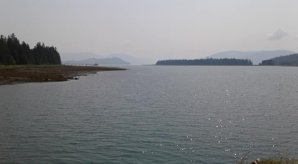
That is all smoke in the distance.
We had some wind that cleared a lot of it out but it has been like this for over a week.
Also it has been in the 80's and unusually warm here.
Most of the fires are up north of me, but I went fishing this morning and the haze from all of the fires is even reaching into southeast Alaska and has been for days. Here is a photo from this morning:
That is all smoke in the distance.
We had some wind that cleared a lot of it out but it has been like this for over a week.
Also it has been in the 80's and unusually warm here.
edit on 10-7-2019 by Darkblade71 because: (no reason given)
a reply to: Darkblade71
We hit a record 90F/32.2C! In Anchorage!!
Most people don’t realize that most houses are designed to retain heat not expel it! My apartment finally went under 79 for the first time in over a week!
All that I know is that I am never going to complain about the cold again!
We hit a record 90F/32.2C! In Anchorage!!
Most people don’t realize that most houses are designed to retain heat not expel it! My apartment finally went under 79 for the first time in over a week!
All that I know is that I am never going to complain about the cold again!
Nothing to see here. The whole world is flooding. Anyone saw news of Siberia flooding? Keep doing coal BBQ guys and dumping radioactive waste. It will
not look like Futurama.
edit on 10-7-2019 by makemap because: (no reason given)
a reply to: TEOTWAWKIAIFF
Same with my trailer.
Who would of thought AC units would be needed!?
There has been talk of mass shellfish die off due to the heat too.
Low tide really messes up the shellfish with the heat.
It is not normal for these parts.
Same with my trailer.
Who would of thought AC units would be needed!?
There has been talk of mass shellfish die off due to the heat too.
Low tide really messes up the shellfish with the heat.
It is not normal for these parts.
a reply to: TEOTWAWKIAIFF
No wildfires here in the Chicago suburbs, because, well, no wild.
Stay safe, leave room for error. And always keep pictures backed up on an easily portable drive (or uploaded somewhere they can be retrieved from.)
I always figured with an insurance check, I can replace everything I actually want, with better versions of them (less, but better "stuff" if all were to burn.) And so, the only things I want to have to grab before "bugging out" are wife, kids, dogs and one Sentry box with the pics & vids hard drive, passports, birth certificates and cash.
To me, part of preparation/ safety has always been knowing I'm ok with leaving the rest behind. Kids each have their one thing too.
We have a yearly quake watch thread, a yearly North Korea thread, and hurricanes... so, maybe a yearly Wildfire thread here on Fragile Earth??
Each year, a different member (or the same, if they are up to the challenge!), would start a [topic: Wildfire YEAR] and reference the previous year(s) thread(s). And whoever wants to update it with new info could. Like the other yearly threads.
The individual ones like Paradise CA would have their own thread anyway...
Seems reasonable. Any thoughts?
a reply to: Darkblade71
I was thinking about the other day and took a photo of the orange sun. I tried to upload it but I got a “wrong format” error.
No desktop to convert iPhone to PNG (or whatever) so no photo.
Anyway it was strange to look at the sun!
ETA: Lowe’s got a pallet in of electric fans. No announcement on the PA. They put it out with a “Sold Out” sign on the front. Less than ten minutes later the pallet was empty!! lol!! My friend’s better half was there!
a reply to: TEOTWAWKIAIFF
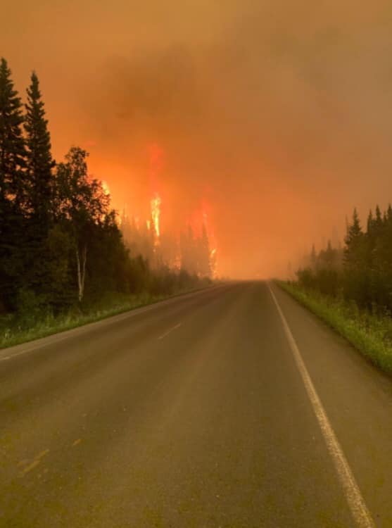
I just saw this photo on facebook so I swiped it.
63 miles north of Fairbanks.
I just saw this photo on facebook so I swiped it.
63 miles north of Fairbanks.
Thinking of you guys. Stay safe people. Hope there aren't any casualties.
a reply to: TEOTWAWKIAIFF
Whoa. Hope you're wearing a filter mask, or learned how to survive without breath!
Whoa. Hope you're wearing a filter mask, or learned how to survive without breath!
originally posted by: Darkblade71
a reply to: TEOTWAWKIAIFF
Most of the fires are up north of me, but I went fishing this morning and the haze from all of the fires is even reaching into southeast Alaska and has been for days. Here is a photo from this morning:
That is all smoke in the distance.
We had some wind that cleared a lot of it out but it has been like this for over a week.
Also it has been in the 80's and unusually warm here.
That's not too bad.
Last August the fires in BC were so bad that you literally couldn't see 50 feet in front of you in Northern Alberta for weeks.
a reply to: Darkblade71
The air got so bad up there that the hospital opened up "smoke rooms" which are the exact opposite of what we think of as smoke rooms! They filtered the air and pressurized the room so those with breathing problems could go breath clean air. Now that is bad!
Ours is more of an inconvenience. And it has kind of cleared out. With it being cooler we have battle going on between smoke and rain! We have a mist falling this morning! It is still gray but does it feel good to walk out in! Ah!!! And according to my mucus, the smoke has lessened (be kind! It is the first time my mucus has announced anything! )
All in all, the moisture in the air should help fire fighters. And if we get rain, well, that would really help out!
Man, I hate wildfire smoke! It used to be an issue every 10 years or so, but now it seems to be every stinking year. Except this year for some weird
reason. Local weather has been pretty wet this spring.
When fire smoke hooks up with my asbestos contamination it really kicks my butt. I opened a box of clothes that I packed away a couple of falls ago and the smoke smell was almost over powering.
Keep the grass mowed (do it in the early morning), and make sure to clear away any brush close to buildings. When the smoke gets bad, N10 filter masks help a lot. If those aren't available or are sold out, keep a bandana in your pocket. Holding a wet cloth over your face can cut some of the smoke and will moisturize the air you breathe in.
Hang in there and try not to breathe too deep.
a reply to: TEOTWAWKIAIFF
Rain is the big thing we need here.
It is supposed to be a rain forest but there has been no rain in a few weeks and high temps.
The area is listed as in severe drought.
Yesterday and this morning we had dry thunder. You could hear it echo through the mountains but no rain.
It is cloudy now but still warm and chance of rain is around 40%.
Looking ahead we will get a few days worth, which we really need, but we need a lot more than what we are getting.
I can't even imagine what it would look like here if we started to get forest fires.
Thousands of miles of pine covered mountains...
Yikes
a reply to: Darkblade71
The Tsongas going up in flame would be apocalyptic! Biblical! And a real shame as it is the last temperate rainforest (iirc).
My buddy says that we will make up for the dryness with a wet August into September. That is if the typical weather patterns hold. June was the hottest on record. Here in Anchorage we hit 89 three times in June. The only reason it was not the record last month is because the official weather station is surrounded by trees and hills in a gulley behind the airport! LOL. With the official record falling on the 4th of July we might see that prediction be pushed back a few weeks (my mucus has nothing to say on the matter! ).
Hope you guys get some rain soon! No thunder storms, as that is why we have the wild fires, but just that sound the trees make when a decent rainstorm passes through!
a reply to: TEOTWAWKIAIFF
I remember seeing huge wildfires when I lived up there.
Not "huge" in the Malibu, California sense of the word (10-20 acres or something) but as far as I could see.
Amazing stuff. Stay safe.
I remember seeing huge wildfires when I lived up there.
Not "huge" in the Malibu, California sense of the word (10-20 acres or something) but as far as I could see.
Amazing stuff. Stay safe.
new topics
-
Mike Pinder The Moody Blues R.I.P.
Music: 30 minutes ago -
Putin, Russia and the Great Architects of the Universe
ATS Skunk Works: 3 hours ago -
A Warning to America: 25 Ways the US is Being Destroyed
New World Order: 8 hours ago
top topics
-
President BIDEN's FBI Raided Donald Trump's Florida Home for OBAMA-NORTH KOREA Documents.
Political Conspiracies: 13 hours ago, 31 flags -
A Warning to America: 25 Ways the US is Being Destroyed
New World Order: 8 hours ago, 13 flags -
Is AI Better Than the Hollywood Elite?
Movies: 15 hours ago, 4 flags -
Mike Pinder The Moody Blues R.I.P.
Music: 30 minutes ago, 2 flags -
Maestro Benedetto
Literature: 15 hours ago, 1 flags -
Putin, Russia and the Great Architects of the Universe
ATS Skunk Works: 3 hours ago, 1 flags
active topics
-
Gaza Terrorists Attack US Humanitarian Pier During Construction
Middle East Issues • 58 • : matafuchs -
Putin, Russia and the Great Architects of the Universe
ATS Skunk Works • 12 • : RussianTroll -
Truth Social goes public, be careful not to lose your money
Mainstream News • 132 • : matafuchs -
New whistleblower Jason Sands speaks on Twitter Spaces last night.
Aliens and UFOs • 67 • : Ophiuchus1 -
Mike Pinder The Moody Blues R.I.P.
Music • 1 • : RussianTroll -
Mood Music Part VI
Music • 3106 • : TheWoker -
University of Texas Instantly Shuts Down Anti Israel Protests
Education and Media • 275 • : Vermilion -
President BIDEN's FBI Raided Donald Trump's Florida Home for OBAMA-NORTH KOREA Documents.
Political Conspiracies • 22 • : 320MPH -
A Warning to America: 25 Ways the US is Being Destroyed
New World Order • 19 • : Cvastar -
Alternate Electors vs Fake Electors - What is the Difference.
2024 Elections • 118 • : Threadbarer