It looks like you're using an Ad Blocker.
Please white-list or disable AboveTopSecret.com in your ad-blocking tool.
Thank you.
Some features of ATS will be disabled while you continue to use an ad-blocker.

Hurricane Irma strengthening in the Atlantic
page: 4share:
originally posted by: AugustusMasonicus
originally posted by: Nyiah
I'm sure you will, Aug, I'm sure you will
Edit: Beer mug does not work well, we need a wine glass icon, dammit!
Looking forward to it since we are leaning towards cancelling the Havana trip since the last thing I want is to get stuck in a country that has crap cell and internet service and one flight a day back home.
Pity if you have to cancel the Havana trip...do we have a Mojito icon?
originally posted by: JohnnyCanuck
Pity if you have to cancel the Havana trip...do we have a Mojito icon?
Yeah, but what can you do. We actually booked it the morning El Presidente made his speech so we're kinda grandfathered in, if we cancel we aren't going to rebook unless the travel policy gets changed back.
First world problems though, I have plenty of other trips lined up.
originally posted by: opethPA
a reply to: St Udio
Or its a hurricane in hurricane season making landfall and causing the same type of destruction that other hurricanes have caused since the dawn of the planet..
Nah it's punishment because America sucks and stuff.
We build on moving fault lines and on fluctuating shorelines. We dam up rivers and build in their flood plains. We establish cities with no perspective on how that land was shaped or we know and take the risk anyway.
Natures footprints are clear. Why we can't stay out of her way is bizarre. It's like watching a heard of elephants trample down a nice flat pice of land and then deciding to pitch a tent on that land because it's nice and flat, Ignoring the fact that the herd of elephants will be making their way back at some point.
Do we expect nature to respect our risks? Do we think the elephants will see that we have our tent up and decide to be quite and go around us.
Keep in mind I include me in this "we", I live in California down stream from very full dam.
edit on 3-9-2017 by Observationalist because:
Spacing
originally posted by: Observationalist
originally posted by: opethPA
a reply to: St Udio
Or its a hurricane in hurricane season making landfall and causing the same type of destruction that other hurricanes have caused since the dawn of the planet..
Nah it's punishment because America sucks and stuff.
We build on moving fault lines and on fluctuating shorelines. We dam up rivers and build in their flood plains. We establish cities with no perspective on how that land was shaped or we know and take the risk anyway.
Natures footprints are clear. Why we can't stay out of her way is bizarre. It's like watching a heard of elephants trample down a nice flat pice of land and then deciding to pitch a tent on that land because it's nice and flat, Ignoring the fact that the herd of elephants will be making their way back at some point.
Do we expect nature to respect our risks? Do we think the elephants will see that we have our tent up and decide to be quite and go around us.
Keep in mind I include me in this "we", I live in California down stream from very full dam.
Since we are talking about hurricanes how would you propose we avoid a variable range hurricane target ? Something that can make landfall in the North East or over the Gulf?
originally posted by: St Udio
IRMA....
the nearest I got was an IRENE... SO the new storm IRMA ain't got no fury to unleash on me
anyone else keep a tally of their list in alphabetical order ?
They have six lists in alphabetical order that they rotate . A different list each year. The names repeat every seven years unless a storm causes damage. Then that name is removed and replaced. Andrew Katrina Matthew Floyd these are all names that are no longer on the lists.
a reply to: Sillyolme
And Harvey will be retired, no doubt about it.
I am becoming increasingly concerned about this storm, I am traveling up the ICW in north Florida on my sailboat. There is a decent a hurricane hole in St Augustine i can hide in, but it wont be fun.
When I was young I would hope for a hit because school would get canceled, now Im older and been through several and would not wish a strike on anyone.
It is becoming more likely with each forecast that Irma will strike the CONUS.
a reply to: wasobservingquietly
The kids built a tree house out of it. Or
They used it to repair the roof that got torn off.
Dude, you live in Florida! Where is the plywood you bought the last time? Don't they save it?
The kids built a tree house out of it. Or
They used it to repair the roof that got torn off.
originally posted by: wasobservingquietly
a reply to: violet
Well, now we're supposed to get some rain from Harvey on Sunday. The gift that keeps on giving!
Depending on the track of Irma, we may get lots more.
When I said that I was tired of 24/7 politics on the news channels & wished that they would find something else to talk about, hurricanes weren't what I had in mind!!!
WOQ
See a perfect example of "be careful what you wish for". Lol. Sorry I couldn't resist.
originally posted by: Nyiah
originally posted by: AugustusMasonicus
originally posted by: SeaWorthy
Fun vacation! You could head for California we are only burning at the moment.
I'll be in Sonoma/Napa in two weeks so I'll get a taste of that too.
I'm sure you will, Aug, I'm sure you will
Edit: Beer mug does not work well, we need a wine glass icon, dammit!
You need a kindle 🍷 they have lots and lots of icons to choose from.
We could even toast with a fruity mixed drink 🍹 or a classic cocktail like a martini 🍸
edit on 932017 by
Sillyolme because: (no reason given)
a reply to: jrod
The rush and adrenaline that occurs during an approaching storm is very quickly replace with melancholy in the days after when you have no power and are making your morning coffee from water you boiled on the grill.
You have to go to work without blow drying your hair. You get up in the night to use the bathroom and out of habit you hit the light and get only dark.. it starts out like a camping trip and devolves into refugee camp.
originally posted by: Sillyolme
a reply to: wasobservingquietly
"Dude, you live in Florida! Where is the plywood you bought the last time? Don't they save it?"
"The kids built a tree house out of it."
Nah...the nice, treehouse trees were blown down!
"They used it to repair the roof that got torn off."
Okay, I'll give you that one! But not EVERYBODY had roof damage.
"See a perfect example of "be careful what you wish for". Lol. Sorry I couldn't resist."
Lol! It isn't the first time that something like that has happened! I've wasted/misused a lot of wishes in my lifetime!!! I even read that story of the 'Genie & The Three Wishes' when I was a kid. You would think I'd know better by now!!!
WOQedit on 3-9-2017 by wasobservingquietly because: Quotes wouldn't work!!!
originally posted by: jadedANDcynical
a reply to: violet
My advice to anyone from Florida to Maine right now is to prepare for a visit from Irma.
And I mean right now.
These 2017 storms are not messing around.
I am rebuking Irma.
She is not allowed to touch Florida shores. She can drop a little rain, we are having plenty of that now anyway, other than that. Irma be gone!
originally posted by: jadedANDcynical
a reply to: violet
My advice to anyone from Florida to Maine right now is to prepare for a visit from Irma.
And I mean right now.
These 2017 storms are not messing around.
Yes I do agree.
I need to check the latest info on it, all I know is it's back at Cat 3.
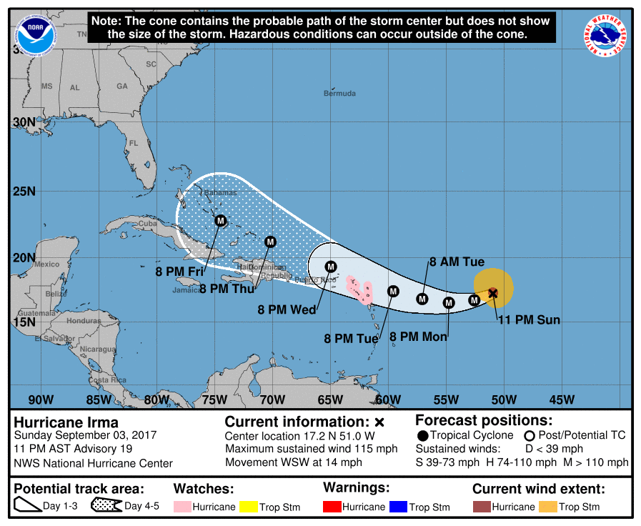
Ok we have a Cone map now,
Category 3
I'll report back with the latest NHC discussions
Category 3
I'll report back with the latest NHC discussions
edit on 3-9-2017 by violet because: (no reason given)
From NHC
...MAJOR HURRICANE IRMA EXPECTED TO BE NEAR THE NORTHERN LEEWARD ISLANDS TUESDAY NIGHT
Hurricane Watch is in effect for...
* Antigua, Barbuda, Anguilla, Montserrat, St. Kitts, and Nevis
* Saba, St. Eustatius, and Sint Maarten
* Saint Martin and Saint Barthelemy
Interests in the remainder of the Leeward Islands, the British and
U.S. Virgin Islands, and Puerto Rico should monitor the progress of
Irma. Additional Hurricane and Tropical Storm Watches may be
required for portions of this area on Monday.
For storm information specific to your area, please monitor
products issued by your national meteorological service.
DISCUSSION AND 48-HOUR OUTLOOK
------------------------------
At 1100 PM AST (0300 UTC), the center of Hurricane Irma was located
near latitude 17.2 North, longitude 51.0 West. Irma is moving
toward the west-southwest near 14 mph (22 km/h). A
west-southwestward to westward motion is expected through Monday
night. On the forecast track, the center of Irma is expected to
approach the northern Leeward Islands late Tuesday.
Maximum sustained winds are near 115 mph (185 km/h) with higher
gusts. Irma is a category 3 hurricane on the Saffir-Simpson
Hurricane Wind Scale. Some strengthening is forecast during the
next 48 hours.
Hurricane-force winds extend outward up to 35 miles (55 km) from the
center and tropical-storm-force winds extend outward up to 140 miles
(220 km).
A NOAA Hurricane Hunter aircraft reported a minimum central
pressure of 961 mb (28.38 inches).
edit on 4-9-2017 by violet because: (no reason given)
Forecast 11pm AST
Hurricane Irma Discussion Number 19
NWS National Hurricane Center Miami FL AL112017
1100 PM AST Sun Sep 03 2017
Observations from a NOAA Hurricane Hunter aircraft indicated a 25 n
mi diameter eye and maximum SFMR-observed surface winds close to
100 kt. That value will be retained for the official intensity.
Central core convection is beginning to become a little better
organized on satellite imagery and the upper-level outflow is
well defined. Given the favorable environment, Irma is likely to
strengthen some more over the next day or two. The official
intensity forecast follows the model consensus.
Based on center fixes from the Hurricane Hunters, Irma has been
moving a little south of west or around 255/12 kt. A strong high
pressure ridge over the central Atlantic should steer Irma on a
west-southward to westward course over the next couple of days.
After that time, a turn toward the west-northwest is likely while
Irma nears the western portion of the ridge. There continues to be
a rather small cross-track spread in most of the track guidance
models, but there are some speed differences. The official track
forecast is roughly in the middle of the guidance and is just
slightly south of the previous NHC prediction.
Users are reminded to not focus on the exact forecast track since
strong winds and heavy rainfall extend well away from the center.
KEY MESSAGES:
1. Irma is expected to affect the northeastern Leeward Islands by
the middle of this week as a major hurricane, accompanied by
dangerous wind, storm surge, and rainfall impacts, along with rough
surf and rip currents. Hurricane watches have been issued for
portions of the Leeward Islands and additional hurricane or tropical
storm watches or warnings may be required on Monday. Residents in
these areas should monitor the progress of Irma and listen to advice
given by officials.
2. Irma is expected to remain a dangerous major hurricane through
the upcoming week and could directly affect the British and U.S.
Virgin Islands, Puerto Rico, Hispaniola, the Turks and Caicos, and
the Bahamas. Residents in all of these areas should monitor the
progress of Irma and listen to advice given by officials. Tropical
storm or hurricane watches could be issued for the British and U.S.
Virgin Islands and Puerto Rico on Monday.
3. It is too early to determine what direct impacts Irma might have
on the continental United States. Regardless, everyone in
hurricane-prone areas should ensure that they have their hurricane
plan in place, as we are now near the peak of the season.
Additional info here:
National Hurricane Center
new topics
-
America's Greatest Ally
General Chit Chat: 20 minutes ago -
President BIDEN's FBI Raided Donald Trump's Florida Home for OBAMA-NORTH KOREA Documents.
Political Conspiracies: 5 hours ago -
Maestro Benedetto
Literature: 6 hours ago -
Is AI Better Than the Hollywood Elite?
Movies: 7 hours ago -
Las Vegas UFO Spotting Teen Traumatized by Demon Creature in Backyard
Aliens and UFOs: 10 hours ago -
2024 Pigeon Forge Rod Run - On the Strip (Video made for you)
Automotive Discussion: 11 hours ago -
Gaza Terrorists Attack US Humanitarian Pier During Construction
Middle East Issues: 11 hours ago
top topics
-
President BIDEN's FBI Raided Donald Trump's Florida Home for OBAMA-NORTH KOREA Documents.
Political Conspiracies: 5 hours ago, 26 flags -
Krystalnacht on today's most elite Universities?
Social Issues and Civil Unrest: 16 hours ago, 9 flags -
Gaza Terrorists Attack US Humanitarian Pier During Construction
Middle East Issues: 11 hours ago, 8 flags -
Supreme Court Oral Arguments 4.25.2024 - Are PRESIDENTS IMMUNE From Later Being Prosecuted.
Above Politics: 16 hours ago, 8 flags -
Weinstein's conviction overturned
Mainstream News: 15 hours ago, 8 flags -
Massachusetts Drag Queen Leads Young Kids in Free Palestine Chant
Social Issues and Civil Unrest: 13 hours ago, 7 flags -
Las Vegas UFO Spotting Teen Traumatized by Demon Creature in Backyard
Aliens and UFOs: 10 hours ago, 6 flags -
Meadows, Giuliani Among 11 Indicted in Arizona in Latest 2020 Election Subversion Case
Mainstream News: 13 hours ago, 5 flags -
2024 Pigeon Forge Rod Run - On the Strip (Video made for you)
Automotive Discussion: 11 hours ago, 4 flags -
Is AI Better Than the Hollywood Elite?
Movies: 7 hours ago, 3 flags
active topics
-
Is AI Better Than the Hollywood Elite?
Movies • 16 • : 5thHead -
Hate makes for strange bedfellows
US Political Madness • 48 • : Terpene -
America's Greatest Ally
General Chit Chat • 0 • : 19Bones79 -
President BIDEN's FBI Raided Donald Trump's Florida Home for OBAMA-NORTH KOREA Documents.
Political Conspiracies • 17 • : BingoMcGoof -
Gaza Terrorists Attack US Humanitarian Pier During Construction
Middle East Issues • 29 • : 19Bones79 -
Supreme Court Oral Arguments 4.25.2024 - Are PRESIDENTS IMMUNE From Later Being Prosecuted.
Above Politics • 90 • : Lumenari -
Las Vegas UFO Spotting Teen Traumatized by Demon Creature in Backyard
Aliens and UFOs • 12 • : KrustyKrab -
SHORT STORY WRITERS CONTEST -- April 2024 -- TIME -- TIME2024
Short Stories • 23 • : DontTreadOnMe -
Truth Social goes public, be careful not to lose your money
Mainstream News • 130 • : Astyanax -
-@TH3WH17ERABB17- -Q- ---TIME TO SHOW THE WORLD--- -Part- --44--
Dissecting Disinformation • 689 • : daskakik