It looks like you're using an Ad Blocker.
Please white-list or disable AboveTopSecret.com in your ad-blocking tool.
Thank you.
Some features of ATS will be disabled while you continue to use an ad-blocker.

Deciphering the Pagan Stones
page: 87share:
a reply to: Logarock
Yes, me too - I can't find any other pictures of it though, which is very annoying. Your Basque idea was a good one, and whilst the 'eye idol' stones may look similar, I found something equally interesting.
Castro Culture
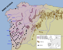
This is a better fit in terms of time and location - Galicia is here, and it's a hop, skip and a jump (or a row) over to where the French Pictones were found.
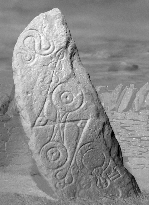
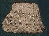
Here's some stones from the area:
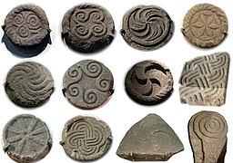
Bottom right looks like a double disc, although I can't see it all.
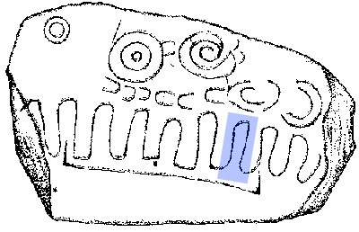
Double disc here is representing a chariot, much like the later Norse stones:
And reminiscent of the German Mainz emblem:
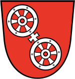
I'm back to wondering about the double disc as chariot wheels, or a stylised version of that.
Yes, me too - I can't find any other pictures of it though, which is very annoying. Your Basque idea was a good one, and whilst the 'eye idol' stones may look similar, I found something equally interesting.
Castro culture (Galician: cultura castrexa, Portuguese: cultura castreja, Asturian: cultura castriega, Spanish: cultura castreña) is the archaeological term for the material Celtic culture of the northwestern regions of the Iberian Peninsula (present-day northern Portugal and the Spanish regions of Galicia, western Asturias and north western León) from the end of the Bronze Age (c. 9th century BC) until it was subsumed by Roman culture (c. 1st century BC). The most notable characteristics of this culture are: its walled oppida and hill forts, known locally as castros, from Latin castrum "castle"
Castro Culture
This is a better fit in terms of time and location - Galicia is here, and it's a hop, skip and a jump (or a row) over to where the French Pictones were found.
Here's some stones from the area:
Bottom right looks like a double disc, although I can't see it all.
Double disc here is representing a chariot, much like the later Norse stones:
And reminiscent of the German Mainz emblem:
I'm back to wondering about the double disc as chariot wheels, or a stylised version of that.
originally posted by: beansidhe
a reply to: Logarock
Yes, me too - I can't find any other pictures of it though, which is very annoying. Your Basque idea was a good one, and whilst the 'eye idol' stones may look similar, I found something equally interesting.
Castro culture (Galician: cultura castrexa, Portuguese: cultura castreja, Asturian: cultura castriega, Spanish: cultura castreña) is the archaeological term for the material Celtic culture of the northwestern regions of the Iberian Peninsula (present-day northern Portugal and the Spanish regions of Galicia, western Asturias and north western León) from the end of the Bronze Age (c. 9th century BC) until it was subsumed by Roman culture (c. 1st century BC). The most notable characteristics of this culture are: its walled oppida and hill forts, known locally as castros, from Latin castrum "castle"
Castro Culture
This is a better fit in terms of time and location - Galicia is here, and it's a hop, skip and a jump (or a row) over to where the French Pictones were found.
Here's some stones from the area:
Bottom right looks like a double disc, although I can't see it all.
Lower left looks like DD and maybe comb or Ogam below.
Great post here. Good to see this thread and you still producing.
Iberian hill forts and Celtiberians, some claim found their way to North America.
a reply to: beansidhe
Just a note....Equinox as new year rather then solstice is still practiced by at least one Hebrew tribe. It looks as the Hebrew practice was rather at odds with most of the nations around them who did the solstice deal. As they scattered other of the tribes may have exercised this tradition until they were Romanized or paganized fully. It was a strong part of their mystic identity, to borrow a phrase.
Just a note....Equinox as new year rather then solstice is still practiced by at least one Hebrew tribe. It looks as the Hebrew practice was rather at odds with most of the nations around them who did the solstice deal. As they scattered other of the tribes may have exercised this tradition until they were Romanized or paganized fully. It was a strong part of their mystic identity, to borrow a phrase.
edit on 1-10-2014 by Logarock because: n
a reply to: Logarock
Hmm, that's interesting. Equinox vs solstice is definitely worth a look into. I think we need a decent thread on Celtiberians in America, there's loads of bits of information scattered about, it would be great to centralise it.
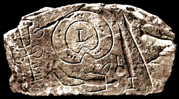
And yes, you know, that is like Ogham - I hadn't seen that. Did the Iberians use Ogham? I shall find out!
Hmm, that's interesting. Equinox vs solstice is definitely worth a look into. I think we need a decent thread on Celtiberians in America, there's loads of bits of information scattered about, it would be great to centralise it.
And yes, you know, that is like Ogham - I hadn't seen that. Did the Iberians use Ogham? I shall find out!
a reply to: beansidhe
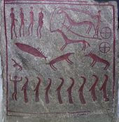
I would personally wonder about that... since even in scotland it is thought that the ancients saw scorpio as a stag.
Here is one link for you:
lastofthedruids.com...
Which tries to tie the kelpie to the constellation Capricorn.
It is interesting to note, rather as a side note, that while in scotland they tied the kelpie to lakes, in Breton and Cornish tales it is an ocean being..
Just a side note on that which may lend the credence to the kelpie possibly being a whale in some celtic tradition.
drawing of a humpback whale, modern day...
edit on 12-10-2014 by OpinionatedB because: (no reason given)
a reply to: OpinionatedB
Hi there!
I like the Last of the Druid's site, he has some good stuff going on there. Yes, he's been trying to tie the stag into a constellation as a way of explaining the animals found all over the stones.
I didn't know they knew about the Kelpie in Breton? I'll need to go and check that out, cheers OB.
I see what you mean about the whale there, it has got a similar look to the beastie. I'm pretty sure it's scorpio/an afanc, as it ties in so well with the tales of Hu Gadarn and the great flood, samhain festival etc. I'm going to find some Breton reading to do, though.
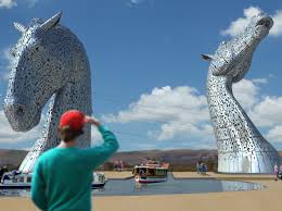
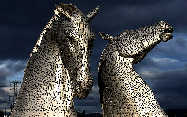
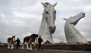
I'll post our Kelpies for you, recently constructed near Glasgow, partly to keep Ramcheck happy and partly because it's high time we had a look at them again. I just love them!
Hi there!
I like the Last of the Druid's site, he has some good stuff going on there. Yes, he's been trying to tie the stag into a constellation as a way of explaining the animals found all over the stones.
I didn't know they knew about the Kelpie in Breton? I'll need to go and check that out, cheers OB.
I see what you mean about the whale there, it has got a similar look to the beastie. I'm pretty sure it's scorpio/an afanc, as it ties in so well with the tales of Hu Gadarn and the great flood, samhain festival etc. I'm going to find some Breton reading to do, though.
I'll post our Kelpies for you, recently constructed near Glasgow, partly to keep Ramcheck happy and partly because it's high time we had a look at them again. I just love them!
a reply to: beansidhe
Greetings right back to you!
Awesome sculptures! Thanks for sharing that!
I will read more also about the ties to Scorpio....all i read so far was your posts, so i will do some additional reading on the topic..
As far as the site... I think he gets his ideas from The Lost Zodiac of the Druids by Gregory Clouter.
edit on 13-10-2014 by
OpinionatedB because: (no reason given)
Hayyy yoooo guyyyyz!
I just saw the beast as a dolphin!
I was watching grand designs last night and there was a house that was built in a pit using "dolphins" to guide the house up during floods. I always see symbolism in that programme and relate it to something or other, it was this beastie this time... Lol.
Take into account that I said it is possible to ride these "beasts" and the void through space was seen as water...
A dolphin is a man-made marine structure that extends above the water level and is not connected to shore.
Typical uses include extending a [re]berth.
"Schmid
Associate Professor of Civil Engineering
April 1963
Dolphins assist the safe maneuvering, berthing and mooring on rivers and in harbors. Although often small and inconspicuous, they are nonetheless important waterfront structures that present intriguing problems to the designing engineer.
A dolphin has two functions: to withstand the continuous pull and to absorb kinetic energy. The former requires high strength, whereas the latter calls for a structure that is sufficiently flexible and resilient at high load to provide a large energy absorption capacity.
To resolve this strength vs. flexibility paradox is one of the problems that has to be faced by the designer. It can best be done if the structural behaviour of a dolphin is clearly understood.
A further difficulty confronting the designer is presented by the fact that often the information regarding the soil conditions at the site is scarce or of questionable reliability if it exists at all, yet soil conditions, of course, most profoundly influence the behaviour of a dolphin.
Recent developments abroad have led to the proposal for the introduction of various new types of dolphins that are claimed to be more economical and in some instances have performed very satisfactorily.
It is the purpose of this report to assess these developments and present a balanced judgment on their merit to provide guide lines for the future development of dolphin design and construction.
It discusses the various types of dolphins and brings together the experience in their design, their construction, and in their service behaviour that has been reported but is widely scattered in the literature.
This Paper presents a generalized theory in matrix formulation for the structural analysis of a pile cluster dolphin.... "
Whoa....
I will keep reading till it fades. I will let you know how far I get. Lol.
www.dtic.mil...
edit on 16-10-2014 by Wifibrains because:
Ref.
edit on 16-10-2014 by Wifibrains because: (no reason
given)
Ref.
edit on 16-10-2014 by Wifibrains because: (no reason given)
extra DIV a reply to: OpinionatedB
I've just ordered The Lost Zodiac.. from Amazon (£1.68 -a veritable bargain), it looks great. I see he uses the Gundestrup cauldron as the basis for his theory, I'm really looking forward to it.
As far as the Scorpio links go, we at ATS are the only people in the world who know that, it was an ATS exclusive!
a reply to: Gordi
As many times as you like! I never get tired of them.
a reply to: Wifibrains
That is such a good analogy for the beastie, in so many ways!! I love the (re)berth idea, that it's of the land but not the land, the link to floods, the struggle between the movement of sea and earth. I might email Kevin McLeod and demand he renames them 'afancs'.
A Breton aside, just as a note of interest. According to Brittany folklore, they arrived in about the 5th or 6th c, fleeing the Anglo-Saxons.
Recognised by their celtic cousins, they set up home in France. They have loads of similar stories about fairies, banshees (c'est moi), kelpies and
standing stones. So, this is important because their history has been transported and so the most important tales will have travelled - in other
words, the shared tales are a great source of 5th/6th c beliefs.
They have Arthurian stories too, which I haven't had a chance to look into, but I will since they might hold some clues.
But the interesting thing about Brittany is of course Carnac and the dolmens there.
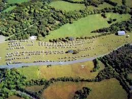
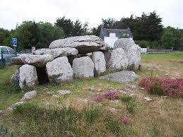
Carnac wiki
Sort of typical henge-y age range, and again typical pre-celtic. But thinking of the Egyptian links earlier, is it not a bit similar to this?
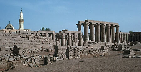
It reminded me of the rows and rows of pillars at Karnak; in fact there used to be an avenue of sphinxes there apparently.
Middle Kingdom is the Hyksos period, if you'll remember the Hyksos similarities with celtic art and design. Just a thought...
They have Arthurian stories too, which I haven't had a chance to look into, but I will since they might hold some clues.
But the interesting thing about Brittany is of course Carnac and the dolmens there.
Carnac is famous as the site of more than 10,000 Neolithic standing stones, also known as menhirs. The stones were hewn from local rock and erected by the pre-Celtic people of Brittany. Local tradition claims that the reason they stand in such perfectly straight lines is that they are a Roman legion turned to stone by Pope Cornelius.[1]
The Carnac stones were erected during the Neolithic period which lasted from around 4500 BC until 2000 BC. The precise date of the stones is difficult to ascertain as little dateable material has been found beneath them, but the site's main phase of activity is commonly attributed to c. 3300 BC. One interpretation of the site is that successive generations visited the site to erect a stone in honour of their ancestors.
Carnac wiki
Sort of typical henge-y age range, and again typical pre-celtic. But thinking of the Egyptian links earlier, is it not a bit similar to this?
It reminded me of the rows and rows of pillars at Karnak; in fact there used to be an avenue of sphinxes there apparently.
The Karnak Temple Complex, commonly known as Karnak (/kɑːr.næk/[1]), comprises a vast mix of decayed temples, chapels, pylons, and other buildings. Building at the complex began during the reign of Senusret I in the Middle Kingdom and continued into the Ptolemaic period, although most of the extant buildings date from the New Kingdom.
Middle Kingdom is the Hyksos period, if you'll remember the Hyksos similarities with celtic art and design. Just a thought...
a reply to: Wifibrains
I'm not having any luck with towers and wells. But I did find something that is right up your alley (I think!).
These ...
could so easily be these:
The cup and ring marks from all over Britain. But what are they? Nobody knows! There are two theories, firstly that they represent constellations which is plausible and the other, that I just stumbled upon, is that they represent energy lines or ley lines. Could this also explain the tuning fork? Maybe. There is no doubt that Scottish folklore is full of stories about fairy lands, otherworld places and 'magic' roads.
Standing
stones and ley lines
If anyone is going to have an opinion on spin torsion fields, I figured it's going to be you! The author goes on to explain how standing stones seem to be placed in lines along ley energy, and that it may have been seen as a road to the otherworld. So, if you buried someone there, on a line, they could travel the road to the otherworld. There's a lot of reading about Rosslyn chapel being on a ley line, along with other sites. It's interesting. If he's right about this, the double discs could symbolise this 'road'.
I'm not having any luck with towers and wells. But I did find something that is right up your alley (I think!).
These ...
could so easily be these:
The cup and ring marks from all over Britain. But what are they? Nobody knows! There are two theories, firstly that they represent constellations which is plausible and the other, that I just stumbled upon, is that they represent energy lines or ley lines. Could this also explain the tuning fork? Maybe. There is no doubt that Scottish folklore is full of stories about fairy lands, otherworld places and 'magic' roads.
Recently, Vincent Reddish, Astronomer Royal for Scotland, and Director of the Edinburgh Observatory, 1975-1980, has researched this energy and believes it is a spin torsion field, caused by the rotation of the Earth, Sun, and Moon.
Particularly interested in the standing stones and circles in my area (Crieff, Perthshire, Scotland), I tuned in to one particular standing stone, and, with ever growing astonishment, followed the waves of energy it emitted across the country. It became increasingly obvious that this was the secret of the ancients - they used this natural telluric energy, focusing it in certain places, for their own purposes.
Eventually, I decided to map the patterns of energy around an ancient cup-marked stone in The Sma’ Glen, north of Crieff. This, as it happened, was the key to the whole system of a very large area. Pecked out of the living rock, or on free-standing boulders like this one, carved on walls of sandstone rock like the beautiful engravings at Mauchline, Ayrshire, and Ormaig in Argyllshire, cup-marks have been discovered world-wide and have over one hundred theories as to their purpose.
Standing
stones and ley lines
If anyone is going to have an opinion on spin torsion fields, I figured it's going to be you! The author goes on to explain how standing stones seem to be placed in lines along ley energy, and that it may have been seen as a road to the otherworld. So, if you buried someone there, on a line, they could travel the road to the otherworld. There's a lot of reading about Rosslyn chapel being on a ley line, along with other sites. It's interesting. If he's right about this, the double discs could symbolise this 'road'.
This might explain it a bit better. He also notes that the stones are on known fault lines across Scotland (there's about 4, if I recall).
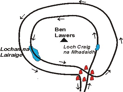
Above: an enlargement of the circuit around Ben Lawers, showing how the stone circle at Machuim (in red) warps one incoming cup-mark ley into two circuits, which are attracted up and over the hills by two lochs (lakes). This is one of the most important functions of stone circles.
Below: Showing how the cup-mark ley spirals out from both the Foulford Inn cup-marked stone and Machuim stone circle.
a reply to: beansidhe
I am again seeing a energy zigzagging activating some of the areas it comes into contact with, reflecting of others. Think of a stone skipping on a pond.
What travels in z directions?.... Cosmic rays again?

Remember this?
I did find some similarities in the quantum well area that sort of looked like these symbols, but had to look at the diagrams "as if" from above instead of the side view presented.
Eg.
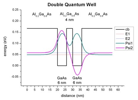
As for the towers/step wells...
There are "spiritual" wells all over India. Some are round step wells similar to the one in the Initiation well thread. but many are kind of square looking and take on a "inverted pyramid" type appearance.
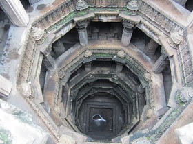
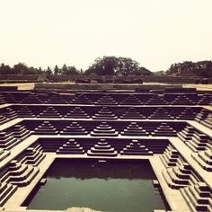
The well in your thread was described as a "inverted tower." Water at the bottom, or top of the wells if you "invert" them was a symbol...
www.atlasobscura.com...
More lending credit to the mystical waters above, these sacred places acted as connection points to the cosmos. To touch the water or be at bottom in a inverted well or tower was to touch the sky or be at the top.
Heaven on earth so to speak.
I am again seeing a energy zigzagging activating some of the areas it comes into contact with, reflecting of others. Think of a stone skipping on a pond.
What travels in z directions?.... Cosmic rays again?
Remember this?
I did find some similarities in the quantum well area that sort of looked like these symbols, but had to look at the diagrams "as if" from above instead of the side view presented.
Eg.
As for the towers/step wells...
There are "spiritual" wells all over India. Some are round step wells similar to the one in the Initiation well thread. but many are kind of square looking and take on a "inverted pyramid" type appearance.
The well in your thread was described as a "inverted tower." Water at the bottom, or top of the wells if you "invert" them was a symbol...
Water plays a special part in Hindu mythology, as a boundary between heaven and earth known as tirtha. As manmade tirtha, the stepwells became not only sources of drinking water, but cool sanctuaries for bathing, prayer, and meditation.
www.atlasobscura.com...
More lending credit to the mystical waters above, these sacred places acted as connection points to the cosmos. To touch the water or be at bottom in a inverted well or tower was to touch the sky or be at the top.
Heaven on earth so to speak.
edit on 1-11-2014 by Wifibrains because: (no reason given)
originally posted by: beansidhe
This might explain it a bit better. He also notes that the stones are on known fault lines across Scotland (there's about 4, if I recall).
Above: an enlargement of the circuit around Ben Lawers, showing how the stone circle at Machuim (in red) warps one incoming cup-mark ley into two circuits, which are attracted up and over the hills by two lochs (lakes). This is one of the most important functions of stone circles.
Below: Showing how the cup-mark ley spirals out from both the Foulford Inn cup-marked stone and Machuim stone circle.
I'm noting the use of water in these "circuits".
Is this theoretical, or is there evidence of these lines?
a reply to: Wifibrains
Hmm. That depends on how particular you are about your evidence.
But he also notes that water is important:
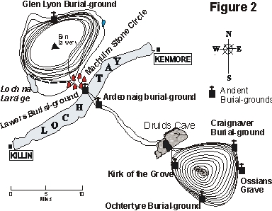
Here's the fault lines in Scotland:
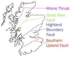
And a henge/circle/stone map to compare:
They do seem to follow those lines...
I like the Indian wells/inverted towers by the way. Heaven on earth, makes sense.
Hmm. That depends on how particular you are about your evidence.
Twenty-five years ago, I watched a programme on “Tomorrow's World” on the use of divining rods, and, to my absolute amazement, discovered for myself that they really did work. This was to give me an insight into the mysterious energies from standing stones and circles, although I had to walk well over three thousand miles, following the sinuous waves of natural telluric energy (ley lines) which standing stones and other artefacts of the megalithic culture emit - little wonder that archaeologists cannot understand them!
But he also notes that water is important:
To enlarge upon this, look at the illustration above. This form of energy is attracted to, and centres itself upon, bodies of water, like Loch Tay to the north-east of the cup-marked stone and Loch na Lairaige to the north-west of Machuim stone circle (circle shewn in red).
It also prefers to contour hills, like Ben Lawers, and to complete this circuit in such a hillly district, the designers had to use (or build?) Loch na Lairaige and Lochan Craig na Mhadaidh at the top of the two hill passes (to the east and west of Ben Lawers) to attract the cup-mark leys up and over the hills. (Loch na Lairaige is now a large reservoir). There are many such lochs and smaller lochans at the summit of hill passes on these circuits - is it possible that at least ome of them were also man-made as part of ley line engineering? - entirely possible given their known abilities.
Here's the fault lines in Scotland:
And a henge/circle/stone map to compare:
They do seem to follow those lines...
I like the Indian wells/inverted towers by the way. Heaven on earth, makes sense.
a reply to: beansidhe
it seems this knowledge has been preserved since the dawn of man, but left open to interpretation... Forgetful lot aint we?... Lol
www.namibiana.de... html
Sound familiar?
I did not see any pictures but I'm associating these...

it seems this knowledge has been preserved since the dawn of man, but left open to interpretation... Forgetful lot aint we?... Lol
In Water, Stone & Legend - Rock Art of the Klein Karoo, archaeologist Renée Rust and photographer Jan van der Poll trace the relationship of San rock art to shamanistic rituals and to stories and legends that still circulate in the Little Karoo today.
The rock art images located in the Karoo, offer a glimpse of an artistic and spiritual world defined by rain and water sources. Today, stories of strange beings, told as the so-called watermeid legend, provide a link to the rock art of the past.
The mountain ravines and hills of the Klein Karoo are endowed with permanent, deep water holes in what is otherwise a semi-arid region. Rock art sites are mostly found close to these water reservoirs, where, so the elders tell us, mythical creatures - watermeide - live.
The stories told of these creatures are an expression of an ancient knowledge, probably as old as the images on the rock faces.
The /Xam, a now-extinct southern San group, told of 'strings that vibrate' that filled their landscape. These were 'thinking strings', a term used by /Xam informants to describe being part of the landscape or physical environment. The /Xam told of the ringing of these strings in the sky, enabling the shaman, the ritual specialist to communicate.
The significance of water and the choice of rock art imagery depicting these elements suggest a spiritual link to the landscape and the locations of particular rock art sites. This link to landscape is an essential feature of myth and ritual. The endurance of the watermeid legend suggests that the thinking strings are still 'alive' and conveys the significance of the places where the water maidens are 'seen' today.
Stories and myths have life beyond generations, and can take us to a distant time when San artists painted on the rock faces. In southern Africa the reading of rock art is based on a connection between the art and the beliefs and practices that focus on myth, ritual and perceptions of the spirit world.
Rock art imagery shows 'ways of doing' in San religious expression, capturing the ritual practices associated with San spiritual beliefs as well as the physical sensations (for example, feelings of flying or swimming) that accompany these rituals.
www.namibiana.de... html
Sound familiar?
I did not see any pictures but I'm associating these...
edit on 1-11-2014 by Wifibrains because: (no reason given)
edit on 1-11-2014 by Wifibrains because: (no reason given)
From the Encyclopaedia of Fairies in World Folklore and Mythology (Theresa Bane) 2013:
"In Brittany, Germany, Ireland and Scotland a fairy path is a sacred fairy space, a rout (sic) said to be walked by the fey between traditional significant sites, such as a FAIRY FORT and a Stone Age monument. These paths are almost always a straight line directly from one place to another....
Many fairy paths run on top of established ley lines."
Google books
There are established ley lines?
I suppose that isn't really relevant, what would matter is if the Picts shared this belief and inscribed it. Our stories of fairy roads came from somewhere, it's entirely possible it came from the Pictish era.
a reply to: Wifibrains
That is an excellent post, well spotted! Thinking strings, what a wonderful way of describing it, I love that.
Who are the watermeid?
Trail rider
A drowning water fairy, you say? That's a coincidence.
That is an excellent post, well spotted! Thinking strings, what a wonderful way of describing it, I love that.
Who are the watermeid?
The "Watermeid" (or Karoo mermaid) has been an integral part of Karoo folklore for years. Stories passed down from parents and grandparents, warn children not to go near deep pools in case the "Watermeid" drags them in and drowns them. Modern man dismissed these stories, saying these stories began as a way to protect children from the dangers of deep water, until archeologists started finding Khoisan "Rock Art" depicting the Watermeid and even groups of these Karoo mermaids.
Trail rider
A drowning water fairy, you say? That's a coincidence.
new topics
-
Ireland VS Globalists
Social Issues and Civil Unrest: 2 minutes ago -
Biden "Happy To Debate Trump"
Mainstream News: 33 minutes ago -
RAAF airbase in Roswell, New Mexico is on fire
Aliens and UFOs: 42 minutes ago -
What is the white pill?
Philosophy and Metaphysics: 2 hours ago -
Mike Pinder The Moody Blues R.I.P.
Music: 2 hours ago -
Putin, Russia and the Great Architects of the Universe
ATS Skunk Works: 6 hours ago -
A Warning to America: 25 Ways the US is Being Destroyed
New World Order: 10 hours ago
top topics
-
President BIDEN's FBI Raided Donald Trump's Florida Home for OBAMA-NORTH KOREA Documents.
Political Conspiracies: 16 hours ago, 34 flags -
A Warning to America: 25 Ways the US is Being Destroyed
New World Order: 10 hours ago, 18 flags -
Mike Pinder The Moody Blues R.I.P.
Music: 2 hours ago, 7 flags -
What is the white pill?
Philosophy and Metaphysics: 2 hours ago, 5 flags -
RAAF airbase in Roswell, New Mexico is on fire
Aliens and UFOs: 42 minutes ago, 4 flags -
Is AI Better Than the Hollywood Elite?
Movies: 17 hours ago, 4 flags -
Biden "Happy To Debate Trump"
Mainstream News: 33 minutes ago, 3 flags -
Putin, Russia and the Great Architects of the Universe
ATS Skunk Works: 6 hours ago, 2 flags -
Maestro Benedetto
Literature: 17 hours ago, 1 flags -
Ireland VS Globalists
Social Issues and Civil Unrest: 2 minutes ago, 0 flags
active topics
-
Gaza Terrorists Attack US Humanitarian Pier During Construction
Middle East Issues • 80 • : Asher47 -
Ireland VS Globalists
Social Issues and Civil Unrest • 0 • : TimBurr -
Biden "Happy To Debate Trump"
Mainstream News • 6 • : KrustyKrab -
New whistleblower Jason Sands speaks on Twitter Spaces last night.
Aliens and UFOs • 73 • : pianopraze -
Meadows, Giuliani Among 11 Indicted in Arizona in Latest 2020 Election Subversion Case
Mainstream News • 27 • : IndieA -
RAAF airbase in Roswell, New Mexico is on fire
Aliens and UFOs • 3 • : Degradation33 -
University of Texas Instantly Shuts Down Anti Israel Protests
Education and Media • 277 • : Threadbarer -
What is the white pill?
Philosophy and Metaphysics • 14 • : kwaka -
Las Vegas UFO Spotting Teen Traumatized by Demon Creature in Backyard
Aliens and UFOs • 16 • : introufo2 -
Post A Funny (T&C Friendly) Pic Part IV: The LOL awakens!
General Chit Chat • 7136 • : underpass61