It looks like you're using an Ad Blocker.
Please white-list or disable AboveTopSecret.com in your ad-blocking tool.
Thank you.
Some features of ATS will be disabled while you continue to use an ad-blocker.

Google Moon: Interesting Feature Near Euler Crater
page: 13
share:
Hello everyone,
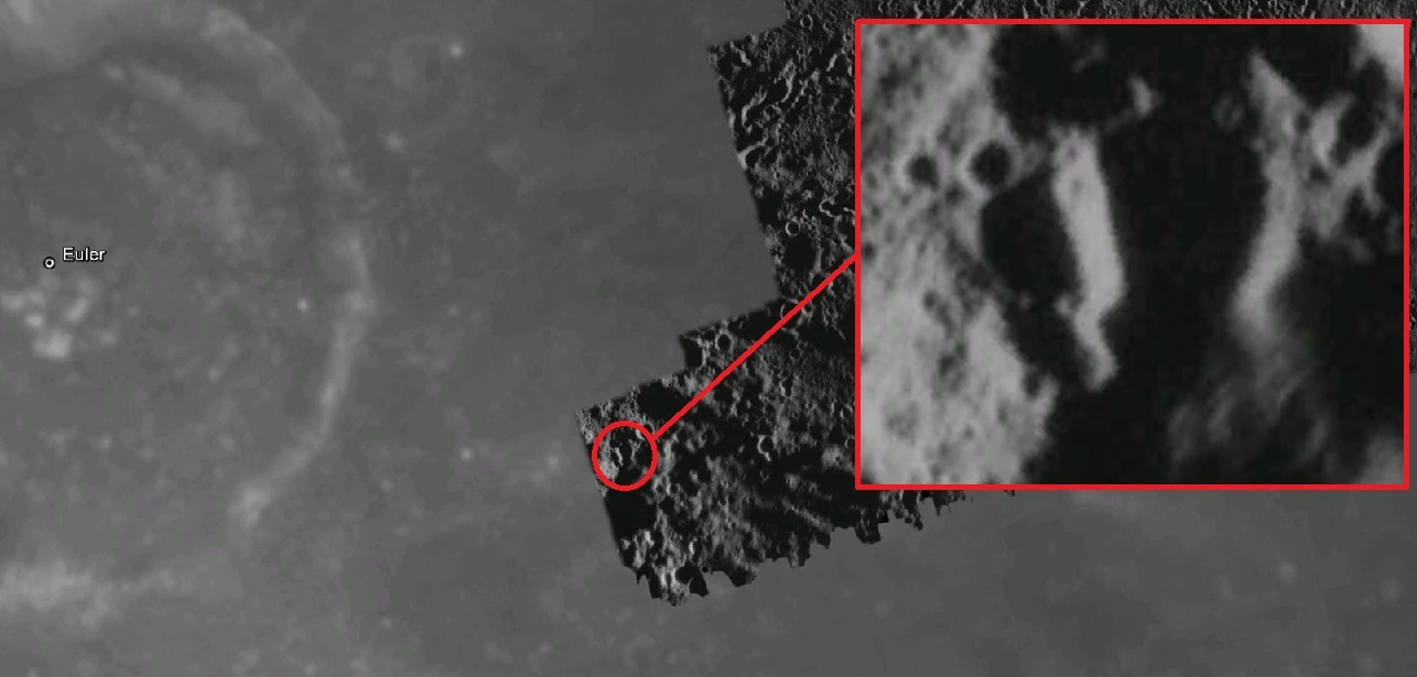
While looking at the Moon through Google Earth recently, I came across an interesting feature around the outside of Euler crater.
(Screenshot: Moon in Google Earth, Euler Crater 23.3°N 29.2°W)
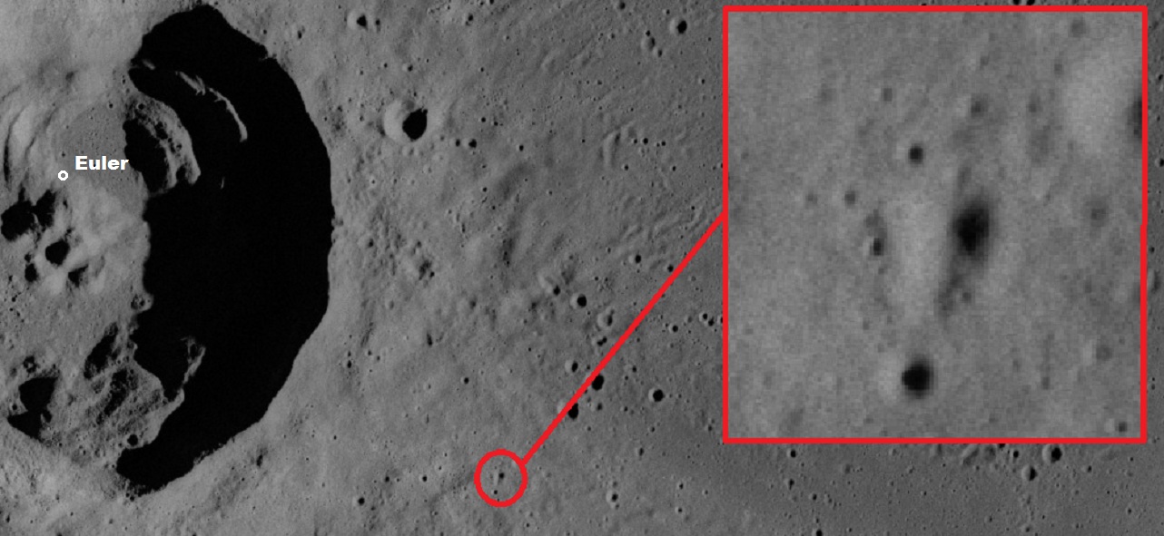
Here's an image (LROC/Apollo Gallery) of the exact same area which shows a rather different terrain, and the feature highlighted in Google Moon doesn't seem to be as predominant anymore.
I know it's a natural feature, I'm not looking for sings of ancient civilizations using Google Moon or anything, I don't believe it can be used for anything conclusive like that (Even though my imagination can't help but think of a giant Stone Tower or Silo type structure)
But why does the terrain look so different between the two images of the exact same area, is it just a trick of light/shadow and elevation/depth, from different pictures takes at different times? I'd really love to find the originals used by Google...
While looking at the Moon through Google Earth recently, I came across an interesting feature around the outside of Euler crater.
(Screenshot: Moon in Google Earth, Euler Crater 23.3°N 29.2°W)
Here's an image (LROC/Apollo Gallery) of the exact same area which shows a rather different terrain, and the feature highlighted in Google Moon doesn't seem to be as predominant anymore.
I know it's a natural feature, I'm not looking for sings of ancient civilizations using Google Moon or anything, I don't believe it can be used for anything conclusive like that (Even though my imagination can't help but think of a giant Stone Tower or Silo type structure)
But why does the terrain look so different between the two images of the exact same area, is it just a trick of light/shadow and elevation/depth, from different pictures takes at different times? I'd really love to find the originals used by Google...
edit on 14-6-2013 by Dominar because:
typo
S&F for not claiming solid undeniable proof of structures on the moon!!
"Those threads" are (imo) ruining ATS and making us all look collectively stoopid.
The people who make "Those Threads" should stay at GLP.
Interesting feature as well.
Good on ya
"Those threads" are (imo) ruining ATS and making us all look collectively stoopid.
The people who make "Those Threads" should stay at GLP.
Interesting feature as well.
Good on ya
edit on 14-6-2013 by canucks555 because: (no reason given)
reply to post by Dominar
Does the terrain on the moon shift over time?
I don't know much about space or the moon for that matter, but could the photos have been taken years apart?
~Tenth
Does the terrain on the moon shift over time?
I don't know much about space or the moon for that matter, but could the photos have been taken years apart?
~Tenth
Were the two images just taken at very different resolutions or something?
reply to post by canucks555
Thanks lol, yeah I'm pretty familiar with those threads and some of the people who start them. I always give them a quick read though sometimes it's intriguing (most of the times... it's rocks).
IF there ever was anything potentially revealing on any images destined for Google Moon/Mars, it would of been removed long before the software was released to basement dwellers...
The lighting is obviously very different.
The lower Sun angle exaggerates terrain features by casting longer shadows.
The lower Sun angle exaggerates terrain features by casting longer shadows.
The moon does rotate so any space based images are going to show different lighting from the passage of sunlight and shadow.
Although I like the white twinkie!
Although I like the white twinkie!
edit on 14-6-2013 by abeverage because: (no reason given)
reply to post by abeverage
That's definitely what it looks like, I'm just surprised at how the lighting makes the same area look almost completely different. It fools my brain and makes me see things lol.
Wish I could just teleport there and see : /
That's definitely what it looks like, I'm just surprised at how the lighting makes the same area look almost completely different. It fools my brain and makes me see things lol.
Wish I could just teleport there and see : /
Originally posted by Dominar
reply to post by abeverage
That's definitely what it looks like, I'm just surprised at how the lighting makes the same area look almost completely different. It fools my brain and makes me see things lol.
Wish I could just teleport there and see : /
When they first released the Mars Orbital image I spent days looking at images found some pretty crazy stuff that looks like the creep from the Zerg in StarCraft but lighting and shadow can make things look surreal.
Originally posted by Dominar
But why does the terrain look so different between the two images of the exact same area, is it just a trick of light/shadow and elevation/depth, from different pictures takes at different times?
That's what it is. It kind of blew my mind when I first started looking at the Apollo Mapping Camera images. The lunar plains look smooth because the low contrast of the lunar soil hides the relief. Only when you get a low sun angle can you see just how rugged the surface really is.
Here are three images of the area around Euler crater taken by Apollo 17's Mapping Camera (open them in separate windows so you can compare):
AS17-M-2293 1972-12-15T21:01:27
AS17-M-2729 1972-12-16T04:57:00 (~8 hours after the first image)
AS17-M-2922 1972-12-16T20:48:20 (~16 hours after the second image)
You can use the zoomable interface to find your area-of-interest to the southeast of the crater.
Zoom in on the west (left) side of the picture, where the sun-angle is lowest. Notice that the mountains on the lower left cast very long shadows in the first image (leading some to mistakenly call them "spires"). As the sun gets higher in the subsequent images, the shadows quickly shorten and disappear. This causes a different "illusion" - That the lunar surface is smooth!
Hope this helps
(P.S. I love your frelling user name!)
edit on 15-6-2013 by Saint Exupery because: corrected spelling. Damn homophones!
Sun angle does indeed make a huge difference, and you can see that in the difference between the two photographs. I'm not entirely sure where that
'stripe' on google moon comes from, but much of the other data is from a combination of probes.
You can get more useful images of the lunar surface by looking at an LRO map viewer:
target.lroc.asu.edu...#
You can also see the pre-Apollo Lunar Orbiter probe views of the surface in Google Moon (under 'Global Maps').
It's a lot of downloading, but you can also download the Virtual Moon Atlas
www.ap-i.net...
The basic set up is OK, but you really need to get all the other bits, including the chinese chang-e dataset, the more detailed Lunar Orbiter and LRO views. They don't go in as close as the LRO viewer.
There's also the Apollo kml file that merges the Apollo 15-17 metric camera data into one file for Google Moon:
byss.ndc.nasa.gov...
That should give you a lot of different views of the same areas to compare!
reply to post by onebigmonkey
Thanks, really appreciate it!
I had looked at the LROC Quickmap but the area in question is much too pixelated
Thank you for the other links too, I had not come across them.
Thanks, really appreciate it!
I had looked at the LROC Quickmap but the area in question is much too pixelated
Thank you for the other links too, I had not come across them.
Are you talking about the thing that looks like a blackhead There are probably a lot of interesting shapes on the moons and planets in the solar
system. I read an article about making a periodic table of recurrent shapes. I found an article on
it...phys.org...
new topics
-
Mike Pinder The Moody Blues R.I.P.
Music: 28 minutes ago -
Putin, Russia and the Great Architects of the Universe
ATS Skunk Works: 3 hours ago -
A Warning to America: 25 Ways the US is Being Destroyed
New World Order: 7 hours ago
top topics
-
President BIDEN's FBI Raided Donald Trump's Florida Home for OBAMA-NORTH KOREA Documents.
Political Conspiracies: 13 hours ago, 31 flags -
A Warning to America: 25 Ways the US is Being Destroyed
New World Order: 7 hours ago, 13 flags -
Is AI Better Than the Hollywood Elite?
Movies: 15 hours ago, 4 flags -
Mike Pinder The Moody Blues R.I.P.
Music: 28 minutes ago, 2 flags -
Maestro Benedetto
Literature: 15 hours ago, 1 flags -
Putin, Russia and the Great Architects of the Universe
ATS Skunk Works: 3 hours ago, 1 flags
active topics
-
Truth Social goes public, be careful not to lose your money
Mainstream News • 132 • : matafuchs -
New whistleblower Jason Sands speaks on Twitter Spaces last night.
Aliens and UFOs • 67 • : Ophiuchus1 -
Gaza Terrorists Attack US Humanitarian Pier During Construction
Middle East Issues • 57 • : ToneD -
Mike Pinder The Moody Blues R.I.P.
Music • 1 • : RussianTroll -
Putin, Russia and the Great Architects of the Universe
ATS Skunk Works • 11 • : CriticalStinker -
Mood Music Part VI
Music • 3106 • : TheWoker -
University of Texas Instantly Shuts Down Anti Israel Protests
Education and Media • 275 • : Vermilion -
President BIDEN's FBI Raided Donald Trump's Florida Home for OBAMA-NORTH KOREA Documents.
Political Conspiracies • 22 • : 320MPH -
A Warning to America: 25 Ways the US is Being Destroyed
New World Order • 19 • : Cvastar -
Alternate Electors vs Fake Electors - What is the Difference.
2024 Elections • 118 • : Threadbarer
3