It looks like you're using an Ad Blocker.
Please white-list or disable AboveTopSecret.com in your ad-blocking tool.
Thank you.
Some features of ATS will be disabled while you continue to use an ad-blocker.

Intersting GOOGLE Maps images,
page: 16
share:
Here are some of the pictures I found while cruising around GOOGLE maps, nothing too crazy, nothing special, just something to step away from some of
ATS' Negative stuff for a minute, and B.S. about some strange/normal photos. If you are looking for U.F.O. stuff or big foot, then I will save you the
time. You won't find that here!
Strange flight line in the middle of the desert?
HAARP Test laser fire? j/k
please feel free to reply with some more, its coffee break time, I will enjoy them thanks!
Strange flight line in the middle of the desert?
HAARP Test laser fire? j/k
please feel free to reply with some more, its coffee break time, I will enjoy them thanks!
edit on 21-5-2013 by I1Am1Ready1Are1You because: (no reason given)
reply to post by I1Am1Ready1Are1You
Best guess:
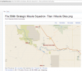
569th Strategic Missile Squadron Titan I Missile Sites
Best guess:
569th Strategic Missile Squadron Titan I Missile Sites
reply to post by I1Am1Ready1Are1You
en.wikipedia.org...

en.wikipedia.org...
edit on 5/21/2013 by this_is_who_we_are because: (no reason given)
reply to post by this_is_who_we_are
Depending on the accuracy of the information given, I would have to say nay on it being site B, it too far off however, it obviously Military related, I also Noticed the lack of security, at least from what the map shows surrounding the Flight line. after I posted the pictures is when I went back in to G.M. and seen the fighter jets, then had to edit to add them, also notice the berms around the planes? i figure to shield them from the wind or explosion blast. I also found it odd that they were park on dirt roads.
Depending on the accuracy of the information given, I would have to say nay on it being site B, it too far off however, it obviously Military related, I also Noticed the lack of security, at least from what the map shows surrounding the Flight line. after I posted the pictures is when I went back in to G.M. and seen the fighter jets, then had to edit to add them, also notice the berms around the planes? i figure to shield them from the wind or explosion blast. I also found it odd that they were park on dirt roads.
reply to post by lambchop
Yeah I used to live on the MHAFB, this location is about 40 miles from where I live now, I was using the map to scout for a new 4x4 offroading spot when I found this, it may be a missile silo, I just expected it to look differently.
Yeah I used to live on the MHAFB, this location is about 40 miles from where I live now, I was using the map to scout for a new 4x4 offroading spot when I found this, it may be a missile silo, I just expected it to look differently.
reply to post by I1Am1Ready1Are1You
it obliviously not the main base but, I think might be part of their training facility. If you use google earth and the timeline function the same planes are in the same location in all the photos from 1998. might be a firing range. The runway is not sealed so might be used to practice landing on dirt... this is all speculation on my behalf
it obliviously not the main base but, I think might be part of their training facility. If you use google earth and the timeline function the same planes are in the same location in all the photos from 1998. might be a firing range. The runway is not sealed so might be used to practice landing on dirt... this is all speculation on my behalf
Pic 4 looks like the craters left after underground nuke tests. But in Idaho?
I think on the fourth one....someone was REALLY drunk on day. lol
Wow, this is coincidental. I think the first picture is pretty close to my current location. What do we got there? Oh! All the pictures are
close.
edit on 21-5-2013 by darkbake because: (no reason given)
reply to post by Magister
I wouldn't be surprised. Although I do remember there being an area kind of like this that is designated as a target range for aircraft to do bombing runs on. This is a good use of Google Maps - we could combine off-roading with conspiracy theories!
I wouldn't be surprised. Although I do remember there being an area kind of like this that is designated as a target range for aircraft to do bombing runs on. This is a good use of Google Maps - we could combine off-roading with conspiracy theories!
edit on 21-5-2013 by darkbake because: (no
reason given)
yeah mostly Idaho, ...
i mean really, are there no bizzaroh behaviors in our tanned country of Australia ??
i call out to our fellow skips ...
*sigh* ... back to watering the smurfs again ...
Muzz
i mean really, are there no bizzaroh behaviors in our tanned country of Australia ??
i call out to our fellow skips ...
*sigh* ... back to watering the smurfs again ...
Muzz
reply to post by this_is_who_we_are
I think you are spot on with the Titan Info heres a map that shows their locations

^^^^What ronthealien said. from his link:
Those parallel tracks running east/west? imagine a herd of wild abrams closing in on their intended prey: the mock airfield location!
Orchard Training Area Located in the southern part of Idaho, Gowen Field is the only Joint Military installation in Idaho and is the only National Guard facility in the region focused on providing Total Joint Force training. For two decades, the installation annually has provided support and facilities for the field and classroom training of military personnel from all services. The Gowen Field complex is adjacent to the Boise International Airport and is located on 576 acres, with the Gowen Field Training Area consisting of 136,948 of which 86,459 is maneuver area, just south of the main post area. A state-of-the-art Multi-Purpose Range Complex –Heavy permits armor, mechanized infantry, combat aviation, dismounted and motorized Units-Army and Air Guard to conduct live-fire exercises and annual crew qualification. Recent additions to training facilities include an Live Fire Convoy Range and a 50 K Mounted Land Navigation Course.
Those parallel tracks running east/west? imagine a herd of wild abrams closing in on their intended prey: the mock airfield location!
reply to post by shells4u
FWIW
My Father was the director of the Titan rocket program in the USAF back when I was a kid growing up, it is his design legacy and he even has an exibit in the Smithsonian Museum of Air and Space Technology in Washington DC dedicated to this invention (though the video in the suvonier shop is kind of cheesy).
Titan I, II, III, and IV were his design before moving on to a certain space project popular on ATS lol , of which I only have limited knowledge of due to classified status.
Yes, those pictures do look like the Titan silos to me.
God Bless,
That airfield is actually part of the Saylor Creek range used primarily by MHAFB, and Gowen - but I'd bet that other bases use it for training
also.
The Orchard training range is around here:
(it's a huge area, so zoom in)
The 569th SMS Titan sites are here:
569-A
As you can see, that one is in a pretty remote area... you cant really see the silos because they covered them with dirt. Lots of dirt.
569-B
Has been a toxic waste facility for over 2 decades that I'm aware of.
569-C
This one is obviously privately owned now, and I'm told the owner doesn't like visitors too much - so probably not a good place to go poking around. You can see the uncovered silos on that one, and note that it's layout is pretty close in resemblance to the other 2.
Couple other interesting old military things from that area are the old Nike sites, I don't believe that they were ever completed and operational though. Mostly whats left of them is just the concrete slabs and footings from the buildings.
Nike Control site A:
Nike Control site B:
I'm not sure where the launch areas for these two are to be found though.
Source:
new topics
-
Where should Trump hold his next rally
2024 Elections: 2 hours ago -
Shocking Number of Voters are Open to Committing Election Fraud
US Political Madness: 3 hours ago -
Gov Kristi Noem Shot and Killed "Less Than Worthless Dog" and a 'Smelly Goat
2024 Elections: 3 hours ago -
Falkville Robot-Man
Aliens and UFOs: 4 hours ago -
James O’Keefe: I have evidence that exposes the CIA, and it’s on camera.
Whistle Blowers and Leaked Documents: 4 hours ago -
Australian PM says the quiet part out loud - "free speech is a threat to democratic dicourse"...?!
New World Order: 5 hours ago -
Ireland VS Globalists
Social Issues and Civil Unrest: 6 hours ago -
Biden "Happy To Debate Trump"
2024 Elections: 6 hours ago -
RAAF airbase in Roswell, New Mexico is on fire
Aliens and UFOs: 6 hours ago -
What is the white pill?
Philosophy and Metaphysics: 8 hours ago
top topics
-
A Warning to America: 25 Ways the US is Being Destroyed
New World Order: 16 hours ago, 21 flags -
Blast from the past: ATS Review Podcast, 2006: With All Three Amigos
Member PODcasts: 8 hours ago, 13 flags -
James O’Keefe: I have evidence that exposes the CIA, and it’s on camera.
Whistle Blowers and Leaked Documents: 4 hours ago, 12 flags -
Australian PM says the quiet part out loud - "free speech is a threat to democratic dicourse"...?!
New World Order: 5 hours ago, 11 flags -
Biden "Happy To Debate Trump"
2024 Elections: 6 hours ago, 10 flags -
Mike Pinder The Moody Blues R.I.P.
Music: 9 hours ago, 8 flags -
Ireland VS Globalists
Social Issues and Civil Unrest: 6 hours ago, 5 flags -
RAAF airbase in Roswell, New Mexico is on fire
Aliens and UFOs: 6 hours ago, 5 flags -
What is the white pill?
Philosophy and Metaphysics: 8 hours ago, 5 flags -
Putin, Russia and the Great Architects of the Universe
ATS Skunk Works: 12 hours ago, 4 flags
active topics
-
Krystalnacht on today's most elite Universities?
Social Issues and Civil Unrest • 11 • : TheWoker -
Remember These Attacks When President Trump 2.0 Retribution-Justice Commences.
2024 Elections • 59 • : TzarChasm -
Salvador Dali's Moustaches
People • 29 • : GENERAL EYES -
Mood Music Part VI
Music • 3111 • : TheWoker -
Where should Trump hold his next rally
2024 Elections • 12 • : StudioNada -
University of Texas Instantly Shuts Down Anti Israel Protests
Education and Media • 310 • : SchrodingersRat -
Candidate TRUMP Now Has Crazy Judge JUAN MERCHAN After Him - The Stormy Daniels Hush-Money Case.
Political Conspiracies • 815 • : Annee -
President BIDEN's FBI Raided Donald Trump's Florida Home for OBAMA-NORTH KOREA Documents.
Political Conspiracies • 35 • : Threadbarer -
2024 Pigeon Forge Rod Run - On the Strip (Video made for you)
Automotive Discussion • 8 • : WhitewaterSquirrel -
Gov Kristi Noem Shot and Killed "Less Than Worthless Dog" and a 'Smelly Goat
2024 Elections • 28 • : cherokeetroy
6