It looks like you're using an Ad Blocker.
Please white-list or disable AboveTopSecret.com in your ad-blocking tool.
Thank you.
Some features of ATS will be disabled while you continue to use an ad-blocker.

Guide: How To Calculate Height of Moon Objects Like A Pro
page: 14
share:
In case anybody may find this information useful, I've posted a guide on how to accurately calculate the actual height of objects found in LROC Narrow
Angle Camera images using a practical example.
The guide goes into how the surface slope affects the an object's apparent shadow length, which is a well known fact. Perhaps the most useful part of the guide for the interested reader may be the demonstration of quick and accurate method of finding the surface slope data for nearly anywhere on the Moon.
Using this guide, I don't see why any motivated reader wouldn't be able to accurately calculate the actual height or depth of a shadow casting object found in LROC NAC images.
Feedback is always welcome especially any correction issues.
How to Calculate Height of Moon Objects Like A Pro
edit on 15-2-2013 by PINGi14 because: (no reason given)
Very good.
It should be pointed out though that the map uses the GLD100 digital terrain map. The resolution of this data is 100m so in uneven terrain calculations over short distances may not be reliable.
wms.lroc.asu.edu...
It should be pointed out though that the map uses the GLD100 digital terrain map. The resolution of this data is 100m so in uneven terrain calculations over short distances may not be reliable.
wms.lroc.asu.edu...
edit on 2/15/2013 by Phage because: (no reason given)
reply to post by PINGi14
What is the height of this tower ?
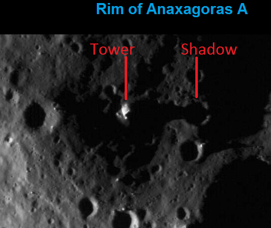
Image Title : The subdued rim of Anaxagoras A, dramatically lit by the lunar sunrise
Date : 2009-06-30
Time : 16:04
Orbit : 73
Center Longitude : -8.84825°
Center Latitude : 72.18645°
Resolution :1.85 m/pixel
wms.lroc.asu.edu...
What is the height of this tower ?
Image Title : The subdued rim of Anaxagoras A, dramatically lit by the lunar sunrise
Date : 2009-06-30
Time : 16:04
Orbit : 73
Center Longitude : -8.84825°
Center Latitude : 72.18645°
Resolution :1.85 m/pixel
wms.lroc.asu.edu...
edit on 16-2-2013 by wolveriine because: (no reason given)
Originally posted by Phage
Very good.
It should be pointed out though that the map uses the GLD100 digital terrain map. The resolution of this data is 100m so in uneven terrain calculations over short distances may not be reliable.
wms.lroc.asu.edu...edit on 2/15/2013 by Phage because: (no reason given)
Thanks. Well, it is said LOLA is great in highly polar regions but loses definition outside polar regions due to the laser's inability to saturate larger equatorial regions with enough data points required to create accurate map. So it kinda 'fills' in the missing area with whatever it feels like, usually just smooth terrain, which looks terrible. GLD100 doesn't need to 'fudge' to fill in the gap between data points so it becomes superior to LOLA with higher terrain elevation accuracy in non-polar regions. It would suck if we had to pick one or the other.
reply to post by wolveriine
I wouldn't hold my breath. It looks like sun's really low plus the shadow casting on a downhill slope.
I wouldn't hold my breath. It looks like sun's really low plus the shadow casting on a downhill slope.
reply to post by PINGi14
GLD100 is better, no doubt.
wms.lroc.asu.edu...
Do you think that with an effective 300 meter resolution with 15 meter vertical accuracy it might be a good idea to come up with a range of possible values for a given calculation? Seems that there's room for a decent margin of error, depending on the circumstance.
GLD100 is better, no doubt.
The resolution, in a formal sense, is probably close to 300 meters, and the accuracy of the elevations is estimated to be about 10 to 20 meters (Scholten et al JGR in press).
wms.lroc.asu.edu...
Do you think that with an effective 300 meter resolution with 15 meter vertical accuracy it might be a good idea to come up with a range of possible values for a given calculation? Seems that there's room for a decent margin of error, depending on the circumstance.
reply to post by wolveriine
I don't get it. You were given the tools to figure this out and yet you still ask for someone else to give you an answer? Also, utilizing the shadow as a point of reference will need to know the reference of the light source in relation to the object.
Ever seen your shadow at dusk or dawn? Are you really 15' tall? Or your shadow at high-noon...are you really only a few inches tall?
Originally posted by Phage
reply to post by PINGi14
GLD100 is better, no doubt.
The resolution, in a formal sense, is probably close to 300 meters, and the accuracy of the elevations is estimated to be about 10 to 20 meters (Scholten et al JGR in press).
wms.lroc.asu.edu...
Do you think that with an effective 300 meter resolution with 15 meter vertical accuracy it might be a good idea to come up with a range of possible values for a given calculation? Seems that there's room for a decent margin of error, depending on the circumstance.
I wouldn't put too much stock in the 300m value quoted on that website. It's more around 100m. I linked the description of the dataset from a research paper dated Aug. 2012. Link to paper
1.2. The GLD100 [ 8 ] The Global Lunar DTM 100 m (GLD100) [Scholten et al., 2011b] was created from over 44,000 LROC WAC stereo images, tied to LOLA data [Smith et al., 2010]. The combined product has a pixel spacing of 100 m, a vertical accuracy of 10–30 m, and is 99.84% complete between 80"N and 80"S (lighting conditions reduce DTM accuracy at higher latitudes). A comparison with LOLA data has deter- mined that the mean difference between GLD100 and LOLA heights is only 4 m, and the 1-s RMS error is 23 m, i.e., less than one-third of a WAC pixel (75 m) [Scholten et al., 2011a]. The added benefit of the GLD100 is the relative lack of data gores, compared to LOLA’s limited cross-track coverage away from the poles. The GLD100 has the vertical precision and spatial coverage necessary to accurately mea- sure peak and peak-ring volumes, in more craters than pre- viously possible. An additional advance since the volume measurements of (e.g.) Croft [1978] and Hale and Grieve [1982] is the existence of improved image processing tools (e.g., ArcMap). These now allow feature volumes to be directly measured from the DTM, rather than via calculation from 2D topographic profiles, thus reducing errors/inaccuracies and lessening the effect of natural variation in crater shape with azimuth.
reply to post by PINGi14
I'm not sure why you would say that. The statement is from Marc Robinson, the Principle Investigator for LROC. I would sort of put stock in what he says about it.
The article you quote mentions pixel spacing, not the elevation resolution. You can read the full explanation here:
lunarnetworks.blogspot.com...
I wouldn't put too much stock in the 300m value quoted on that website.
I'm not sure why you would say that. The statement is from Marc Robinson, the Principle Investigator for LROC. I would sort of put stock in what he says about it.
The article you quote mentions pixel spacing, not the elevation resolution. You can read the full explanation here:
lunarnetworks.blogspot.com...
edit on 2/16/2013 by Phage because: (no reason given)
reply to post by Phage
Aw come on Phage, dont tell me you are questioning the quality of GLD100 dataset. Scientists are publishing lunar research papers using GLD100 or combination of and LOLA and GLD100 data all the time. It's simply the best available terrain elevation data for non polar regions of the Moon you can find today.
Aw come on Phage, dont tell me you are questioning the quality of GLD100 dataset. Scientists are publishing lunar research papers using GLD100 or combination of and LOLA and GLD100 data all the time. It's simply the best available terrain elevation data for non polar regions of the Moon you can find today.
reply to post by PINGi14
I'm saying that those who know how it was produced say it has an effective horizontal resolution of 300 meters. And that that and the vertical uncertainty should be considered in calculating the height of objects base on their shadow length.
I'm saying that those who know how it was produced say it has an effective horizontal resolution of 300 meters. And that that and the vertical uncertainty should be considered in calculating the height of objects base on their shadow length.
I agree.
It's simply the best available terrain elevation data for non polar regions of the Moon you can find today.
edit on
2/16/2013 by Phage because: (no reason given)
new topics
-
Gov Kristi Noem Shot and Killed "Less Than Worthless Dog" and a 'Smelly Goat
2024 Elections: 22 minutes ago -
Falkville Robot-Man
Aliens and UFOs: 36 minutes ago -
James O’Keefe: I have evidence that exposes the CIA, and it’s on camera.
Whistle Blowers and Leaked Documents: 1 hours ago -
Australian PM says the quiet part out loud - "free speech is a threat to democratic dicourse"...?!
New World Order: 2 hours ago -
Ireland VS Globalists
Social Issues and Civil Unrest: 2 hours ago -
Biden "Happy To Debate Trump"
Mainstream News: 3 hours ago -
RAAF airbase in Roswell, New Mexico is on fire
Aliens and UFOs: 3 hours ago -
What is the white pill?
Philosophy and Metaphysics: 4 hours ago -
Mike Pinder The Moody Blues R.I.P.
Music: 5 hours ago -
Putin, Russia and the Great Architects of the Universe
ATS Skunk Works: 8 hours ago
top topics
-
A Warning to America: 25 Ways the US is Being Destroyed
New World Order: 12 hours ago, 21 flags -
Biden "Happy To Debate Trump"
Mainstream News: 3 hours ago, 7 flags -
Mike Pinder The Moody Blues R.I.P.
Music: 5 hours ago, 7 flags -
What is the white pill?
Philosophy and Metaphysics: 4 hours ago, 5 flags -
Australian PM says the quiet part out loud - "free speech is a threat to democratic dicourse"...?!
New World Order: 2 hours ago, 5 flags -
RAAF airbase in Roswell, New Mexico is on fire
Aliens and UFOs: 3 hours ago, 4 flags -
Putin, Russia and the Great Architects of the Universe
ATS Skunk Works: 8 hours ago, 3 flags -
Ireland VS Globalists
Social Issues and Civil Unrest: 2 hours ago, 3 flags -
James O’Keefe: I have evidence that exposes the CIA, and it’s on camera.
Whistle Blowers and Leaked Documents: 1 hours ago, 3 flags -
Falkville Robot-Man
Aliens and UFOs: 36 minutes ago, 1 flags
active topics
-
Candidate TRUMP Now Has Crazy Judge JUAN MERCHAN After Him - The Stormy Daniels Hush-Money Case.
Political Conspiracies • 797 • : Vermilion -
Gov Kristi Noem Shot and Killed "Less Than Worthless Dog" and a 'Smelly Goat
2024 Elections • 13 • : FlyersFan -
Putin, Russia and the Great Architects of the Universe
ATS Skunk Works • 25 • : SchrodingersRat -
Ditching physical money
History • 22 • : StudioNada -
Biden "Happy To Debate Trump"
Mainstream News • 33 • : YourFaceAgain -
Falkville Robot-Man
Aliens and UFOs • 3 • : KKLOCO -
University of Texas Instantly Shuts Down Anti Israel Protests
Education and Media • 296 • : KrustyKrab -
Krystalnacht on today's most elite Universities?
Social Issues and Civil Unrest • 10 • : xuenchen -
Russia Ukraine Update Thread - part 3
World War Three • 5736 • : YourFaceAgain -
Manor Lords - Medieval City Builder with RTS Combat - Early Access 26th April
Video Games • 7 • : gortex
4