It looks like you're using an Ad Blocker.
Please white-list or disable AboveTopSecret.com in your ad-blocking tool.
Thank you.
Some features of ATS will be disabled while you continue to use an ad-blocker.

The Naska Lines: An Alien Blueprint. (amazing discovery!)
page: 1share:
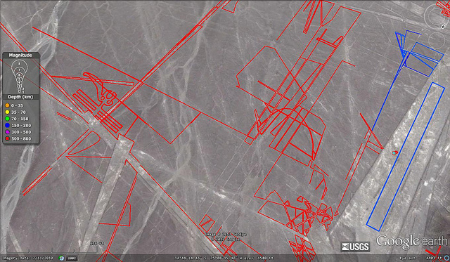
Hello ATS! This is my first official thread and I am very excited. I believe I have something new here.. something well, amazing.. I have been
spending a lot of time looking at the Nazka lines in Google Earth. I am not talking about the hummingbird, ant or any other of the animal geoglyphs..
The lines in between...That's where the blueprint is.
I started to trace the lines and it just looked like chaos. It wasn't until I deleted my work and started over.. this time paying special attention to which lines cross over and which ones cross under.. Knowing this, there was only one thing I could do.. So Instead of tracing the lines, I outlined them on both sides... and presto!
The problem is, there is way too much work for one man to do alone. I have spent hours upon hours, upon hours doing this and I figure I am only maybe 5 percent done. The detail that is drawn in the sand is meticulous. I originally wanted all the fame and glory that comes with such discoveries.. but after realizing it would take me a lifetime by myself I decided to open up my work to the ATS.
If anyone is interested, I think there is a way to send what I have done in Google Earth but I don't know how yet.
Below is a link to several pictures. Let me know what you think ATS!
The first few pictures are some "before" pictures, Cycle through to see my work.
edit on 13-2-2013 by FuzzyNintendo because: I forgot
edit on 13-2-2013 by FuzzyNintendo because: forgot
reply to post by FuzzyNintendo
So you drew these "runway looking" features onto the background? If so, what was there before you "embellished" these photos?
If I may, it seems that the erosion of the land would have washed these out. And if "runways" there is a very dangerous approach (against the cliff) for the one on top.
I see you say you put a lot of work into this, just asking a couple questions...
reply to post by intrptr
The lines that I "drew" in, are just to highlight the lines that are already there. I provided before and after pictures to show this. I do not believe they are runways, I am not really sure what they are. If you load up google earth and look at these areas you will see the lines I have outlined.
The lines that I "drew" in, are just to highlight the lines that are already there. I provided before and after pictures to show this. I do not believe they are runways, I am not really sure what they are. If you load up google earth and look at these areas you will see the lines I have outlined.
reply to post by FuzzyNintendo
I'm sorry, I see the pother photos now. Good job in outlining those. You got me. Ancient airports or terraced growing fields with water aqueducts?
Edit to add: When I say runways, I mean some of these look like airport tarmacs with taxi ways and revetments.
If viewed from an "approach" the markings on the ground just "look like" that.
nazca "lines"
I know it is an oft touted idea. I have trouble with it because why would UFO's that hover need air strips?
And why would an arid desert landscape need long tracts of land to grow crops?
I'm sorry, I see the pother photos now. Good job in outlining those. You got me. Ancient airports or terraced growing fields with water aqueducts?
Edit to add: When I say runways, I mean some of these look like airport tarmacs with taxi ways and revetments.
If viewed from an "approach" the markings on the ground just "look like" that.
nazca "lines"
edit on 13-2-2013 by intrptr because: additional...
I know it is an oft touted idea. I have trouble with it because why would UFO's that hover need air strips?
And why would an arid desert landscape need long tracts of land to grow crops?
edit on 13-2-2013 by intrptr because: further
Someone has probably already mentioned this before concerning these unusual lines on the landscape but they look a lot like electrical schematics to
me.
Like this:

Like this:
reply to post by intrptr
To me it looks technological. Because of the dead ends and more than 45 degree turns, I can't imagine its water related, especially since the Nazka people were very good at finding water and making aqueducts. To me, It's a message or a sign, or something. But the time and work that had to have gone into this... I don't know. It's awesome though!
To me it looks technological. Because of the dead ends and more than 45 degree turns, I can't imagine its water related, especially since the Nazka people were very good at finding water and making aqueducts. To me, It's a message or a sign, or something. But the time and work that had to have gone into this... I don't know. It's awesome though!
reply to post by Tardacus
Right on, that was one of my first thoughts. I suppose that's why I called it a blueprint, but maybe schematics are more fitting. I just wish I had a technological or engineering background to look at this from a different angle.
Right on, that was one of my first thoughts. I suppose that's why I called it a blueprint, but maybe schematics are more fitting. I just wish I had a technological or engineering background to look at this from a different angle.
reply to post by intrptr
I know what you mean. The stranger thing is, while looking at it in Google Earth from different angles, sometimes it looks almost 3D. Especially if you remove the earth and look at just the lines with a black background. Tomorrow I may post some of those just for kicks.
I know what you mean. The stranger thing is, while looking at it in Google Earth from different angles, sometimes it looks almost 3D. Especially if you remove the earth and look at just the lines with a black background. Tomorrow I may post some of those just for kicks.
reply to post by FuzzyNintendo
S n f op!
Very interesting, it is very clear from the work you have already done that it will take alot of time and effort. Unless sombody knows of or can write a program that would automatically outline the lines for you.
On another note, I do believe I am seeing what you were alluding to about there being schematics written out. I see many blgeometric shapes etc... but I am unsure wether this is because they are there to be seen, or my mind is making shapes out of random noise.
Very well done op, please keep us up to date as you and hopefully others make progress. Maybe have a color ckoding scheme that allows you to compare like images from different spots. Or where it may simply be. That they used giant perspective lines to align larger shapes. Just a couple of ideas to help simplify the interpretation part, but a crap ton of extra work on the front side, since you would wanna save a lot of different templates for later use or investigation when trying to piece it all together like NASA does wigh pics from the moon and kther planets.
Thanks for sharing & Good job!
Surely significant for serious seekers!
Due to the immense amount of lines and their close proximity, making it nearly incomprehensible, it may prove more productive to focus on areas with discernible patterns and obvious connections to surrounding icons.
LOVE
Surely significant for serious seekers!
Due to the immense amount of lines and their close proximity, making it nearly incomprehensible, it may prove more productive to focus on areas with discernible patterns and obvious connections to surrounding icons.
LOVE
reply to post by FuzzyNintendo
Please do. Your photos got me all buggered about their origins and purpose again. It is still undeciphered...
Blue print or schematic for what? They made tapestries and clothing that are found on mummified remains as well as art on pottery and it looks nothing like this. If the indigenous population made these? Like you say there was an enormous amount of effort put into it in a desert clime where resources are already thin.
Others will be along to clue us in, I am sure.
Some of it looks like nonsense. Some looks a it like an electrical diagram. Some looks like art. One looks like a flying machine. After burners and
all. Good thread!
The first one that I see is very obviously a gear. Interesting indeed!
reply to post by JayinAR
I agree some does look like nonsense.. but I think that is because they are not complete or I haven't gone over them to outline instead of trace.. some of it I have not redone.. or it's something we just don't understand yet.
I agree some does look like nonsense.. but I think that is because they are not complete or I haven't gone over them to outline instead of trace.. some of it I have not redone.. or it's something we just don't understand yet.
I wonder if anyone has ever done a full scale land survey of the lines. It would be interesting to see a professional quality map of the entire thing
to include accurate measurements of each line. Angles. Etc. If there is a code here, it should be evident in the math.
Very cool.. Exactly why I joined ats
star... And I will come back and flag as soon as the site will let me?
star... And I will come back and flag as soon as the site will let me?
In this one It looks to me like a half drawn 3-d image. very cool
Great topic.
I'm very interested.
However, I don't know if it is my old eyes or scratched glasses or what. But even your embellishment didn't register much to me.
It would be much more interesting and helpful if you had the lines on a layer say in Photoshop, that you could then isolate on a plain background so that just the embellished lines were showing.
Until then, I'm afraid I won't get much out of all your masterful effort. That's sad and frustrating.
reply to post by BO XIAN
The first few that I outlined are in a real light blue color. Unfortunately, changing the color means deleting and starting over. The last several are in red. Tomorrow I plan on posting the lines on a black background.
The first few that I outlined are in a real light blue color. Unfortunately, changing the color means deleting and starting over. The last several are in red. Tomorrow I plan on posting the lines on a black background.
new topics
-
BIDEN Admin Begins Planning For January 2025 Transition to a New President - Today is 4.26.2024.
2024 Elections: 13 minutes ago -
Big Storms
Fragile Earth: 1 hours ago -
Where should Trump hold his next rally
2024 Elections: 4 hours ago -
Shocking Number of Voters are Open to Committing Election Fraud
US Political Madness: 5 hours ago -
Gov Kristi Noem Shot and Killed "Less Than Worthless Dog" and a 'Smelly Goat
2024 Elections: 5 hours ago -
Falkville Robot-Man
Aliens and UFOs: 6 hours ago -
James O’Keefe: I have evidence that exposes the CIA, and it’s on camera.
Whistle Blowers and Leaked Documents: 6 hours ago -
Australian PM says the quiet part out loud - "free speech is a threat to democratic dicourse"...?!
New World Order: 7 hours ago -
Ireland VS Globalists
Social Issues and Civil Unrest: 8 hours ago -
Biden "Happy To Debate Trump"
2024 Elections: 8 hours ago
top topics
-
James O’Keefe: I have evidence that exposes the CIA, and it’s on camera.
Whistle Blowers and Leaked Documents: 6 hours ago, 13 flags -
Blast from the past: ATS Review Podcast, 2006: With All Three Amigos
Member PODcasts: 10 hours ago, 13 flags -
Australian PM says the quiet part out loud - "free speech is a threat to democratic dicourse"...?!
New World Order: 7 hours ago, 12 flags -
Biden "Happy To Debate Trump"
2024 Elections: 8 hours ago, 12 flags -
Mike Pinder The Moody Blues R.I.P.
Music: 11 hours ago, 8 flags -
What is the white pill?
Philosophy and Metaphysics: 10 hours ago, 6 flags -
Shocking Number of Voters are Open to Committing Election Fraud
US Political Madness: 5 hours ago, 6 flags -
RAAF airbase in Roswell, New Mexico is on fire
Aliens and UFOs: 8 hours ago, 5 flags -
Ireland VS Globalists
Social Issues and Civil Unrest: 8 hours ago, 5 flags -
Where should Trump hold his next rally
2024 Elections: 4 hours ago, 4 flags
active topics
-
Gov Kristi Noem Shot and Killed "Less Than Worthless Dog" and a 'Smelly Goat
2024 Elections • 39 • : Zanti Misfit -
So this is what Hamas considers 'freedom fighting' ...
War On Terrorism • 268 • : TheWoker -
BIDEN Admin Begins Planning For January 2025 Transition to a New President - Today is 4.26.2024.
2024 Elections • 2 • : NoCorruptionAllowed -
Falkville Robot-Man
Aliens and UFOs • 7 • : KKLOCO -
Big Storms
Fragile Earth • 9 • : nerbot -
"We're All Hamas" Heard at Columbia University Protests
Social Issues and Civil Unrest • 294 • : TheWoker -
Where should Trump hold his next rally
2024 Elections • 15 • : Zanti Misfit -
Gaza Terrorists Attack US Humanitarian Pier During Construction
Middle East Issues • 89 • : AlongCameaSpider -
Post A Funny (T&C Friendly) Pic Part IV: The LOL awakens!
General Chit Chat • 7138 • : baddmove -
Ireland VS Globalists
Social Issues and Civil Unrest • 8 • : nugget1