It looks like you're using an Ad Blocker.
Please white-list or disable AboveTopSecret.com in your ad-blocking tool.
Thank you.
Some features of ATS will be disabled while you continue to use an ad-blocker.

Quake Watch 2013
page: 76share:
another asian quake 11 minutes ago
geofon.gfz-potsdam.de...
F-E Region: Sichuan, China
Time: 2013-04-20 00:02:48.5 UTC
Magnitude: 6.7
Epicenter: 102.91°E 30.32°N
Depth: 10 km
Status: A - automatic
geofon.gfz-potsdam.de...
edit on 19-4-2013 by muzzy because: (no reason given)
Magnitude 7.0 quake strikes Szechuan region of china: USGS
2013-04-20 00:02:48 UTC
2013-04-20 08:02:48 UTC+08:00 at epicenter
2013-04-19 20:02:48 UTC-04:00 system time
Location
30.314°N 102.934°E depth=16.4km (10.2mi)
Nearby Cities
51km (32mi) WSW of Linqiong, China
98km (61mi) ENE of Kangding, China
115km (71mi) WSW of Chengdu, China
115km (71mi) NW of Leshan, China
1069km (664mi) NNW of Ha Noi, Vietnam
edit on 19-4-2013 by kennvideo because: more info
reply to post by muzzy
And EMSC
www.emsc-csem.org...
Not on USGS yet
Just noticed this
On the USGS Interactive site.
The 'list' is a listnot a Map and List and before this just said try the mobile list.
Apologies it is. It has a map s well. What a heap of junk compared to the 'new' interactive site.
I felt constrained to contact them. This is what I said.
And EMSC
www.emsc-csem.org...
Not on USGS yet
Just noticed this
Earthquakes - 30 days, M2.5+
ANSS Logo GSN Logo
This interface will be replaced by the new BETA Earthquake Map/List within the next few weeks.
On the USGS Interactive site.
The 'list' is a list
Apologies it is. It has a map s well. What a heap of junk compared to the 'new' interactive site.
I felt constrained to contact them. This is what I said.
Are you seriously suggesting that PC users have to put up with that Beta site that was supposed to be for mobile phones?
It is a total backward step and really not good for the image of the USGS. There are independent sites that produce better lists/maps than that.
A mobile style map is of no interest to me, for example, and the adaptability of the 'new' interactive site was good.
This is a SERIOUS retrograde step if you go ahead.
edit on 19/4/2013 by PuterMan because: (no reason given)
thanks for the updates...I did not see this thread pop up after the big quake in iran so I looked for it.
We seem to be having a period of clustering over the last week or so. Asia seems to be rocking from one side to the other.
I would not be surprised at all if we get another sizeable quake in the next day or two.
Taiwan maybe???
I would not be surprised at all if we get another sizeable quake in the next day or two.
Taiwan maybe???
Originally posted by ericblair4891
We seem to be having a period of clustering over the last week or so. Asia seems to be rocking from one side to the other.
I would not be surprised at all if we get another sizeable quake in the next day or two.
Taiwan maybe???
I say Near Mexico coastline above Mexico City or finally here Near Los Angeles
Danger zone near The Cook Islands in the South Pacific Ocean region at 14 Mhz www.ips.gov.au...
Mexico coast line near Mexico city at 13 mhz
edit on 7/30/2012 by dreamfox1 because: Ionospheric Map
reply to post by PuterMan
yeah they've gone and broken the Travel Times Calculator as well
neic.usgs.gov...
i had a look at the alternative they suggested and managed to get as far as unloading the zip file, after that I have no clue what do do with it.
Oh well there goes my LISS SNZO page, I did one graph for the 2nd April OK as they were pretty obvious, but the next one on the 5th had multiple traces on several lines so I need the TTC to work out which ones they were.
I'll keep saving the images anyway, hopefully they fix it soon.
edit on 19-4-2013 by muzzy because: (no reason given)
I expected the Chinese to call it a 7Ms
bunch of aftershocks already
data.earthquake.cn...
this won't be good, Ya'an City 340,000 population, quake was about 36km away
bunch of aftershocks already
2013-04-20 , 08:52:23.2 , 30.2 , 102.8 , 13 , Ms3.7 , Ya'an, Sichuan Province,
2013-04-20 , 08:50:34.4 , 30.1 , 102.8 , 16 , Ms3.1 , Ya'an, Sichuan Province
2013-04-20 , 08:42:35.1 , 30.3 , 102.9 , 20 , Ms3.6 , Ya'an City, Sichuan Province
2013-04-20 , 08:37:12.2 , 30.2 , 102.9 , 19 , Ms4.1 , Ya'an City, Sichuan Province
2013-04-20 , 08:31:34.5 , 30.4 , 102.9 , 12 , Ms4.1 , Ya'an City, Sichuan Province
2013-04-20 , 08:27:25.7 , 30.3 , 102.9 , 15 , Ms3.6 , Ya'an City, Sichuan Province
2013-04-20 , 08:07:32.0 , 30.3 , 102.9 , 10 , Ms5.1 , Ya'an City, Sichuan Province
2013-04-20 , 08:06:38.0 , 30.2 , 102.9 , 10 , Ms4.8 , Ya'an City, Sichuan Province
2013-04-20 , 08:02:46.0 , 30.3 , 103.0 , 13 , Ms7.0 , Ya'an City, Sichuan Province
data.earthquake.cn...
edit on 19-4-2013 by muzzy because: (no reason given)
this won't be good, Ya'an City 340,000 population, quake was about 36km away
edit on 19-4-2013 by muzzy because: (no reason given)
reply to post by muzzy
So far around 100 dead and injured going by early reports.
Not good, but at least so far these big ones aren't striking directly any major city, thankfully.
Don't believe this will be the last 7+ for the month though.
So far around 100 dead and injured going by early reports.
Not good, but at least so far these big ones aren't striking directly any major city, thankfully.
Don't believe this will be the last 7+ for the month though.
My question is,and correct me if I'm wrong,do you think with this increase in the number seismic magnitudes , would there be a sort of domino
effect,shaking some other stress zones loose. Some stress zones that haven't seen a significant release in pressure.
Peace,
K
Peace,
K
reply to post by kdog1982
Na mate, its more like ping-pong out there
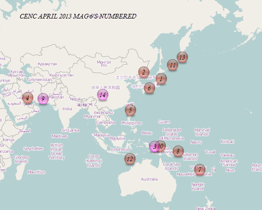
I did a couple of maps to check out what you were wondering
Data is April up till now from CENC (China), they give you more mag sixes for your bucks, compared to USGS/ANSS, most of CENC data is Ms type with the odd mb. In this case all the ANSS data is Mw
In the first map I have numbered them in order.
Open the interactive map.
It has both CENC and ANSS data loaded, play around clicking and un-clicking the boxes on the left hand side menu to see the 3 events that ANSS gave away to the "mag 5 club"
[color=lime](click image for interactive map, opens in new tab/window)
If you can't get each file to open separately at least you can click on an icon and see both popup tags with the info, just click the blue " next" text to see the other one beneath.
on this second (non interactive) map I have laid (red) tracks between the first (Honshu mag 6) and last quake (China mag 7) and then placed them over the (black) tectonic plates boundries, to see if there was any correlation there.
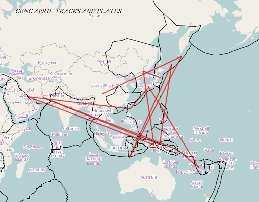
If there was a domino effect the lines wouldn't be in such a muddle zig-zagging like they are.
These are all the mag 6+ for April, interesting that they are all just in this corner of the planet.
To me it looks like the Arabian, Australian and Philippine plates are jiggling about against Asia, why India hasn't moved is the big question?.
Or could it be that India HAS moved and is trying to squeeze in there between Arabia and Indonesia, shunting the other plates to the East and West out of the way.
Himalaya/Kashmir/Tibet quake pending maybe ?
Na mate, its more like ping-pong out there
I did a couple of maps to check out what you were wondering
Data is April up till now from CENC (China), they give you more mag sixes for your bucks, compared to USGS/ANSS, most of CENC data is Ms type with the odd mb. In this case all the ANSS data is Mw
In the first map I have numbered them in order.
Open the interactive map.
It has both CENC and ANSS data loaded, play around clicking and un-clicking the boxes on the left hand side menu to see the 3 events that ANSS gave away to the "mag 5 club"
[color=lime](click image for interactive map, opens in new tab/window)
If you can't get each file to open separately at least you can click on an icon and see both popup tags with the info, just click the blue " next" text to see the other one beneath.
on this second (non interactive) map I have laid (red) tracks between the first (Honshu mag 6) and last quake (China mag 7) and then placed them over the (black) tectonic plates boundries, to see if there was any correlation there.
If there was a domino effect the lines wouldn't be in such a muddle zig-zagging like they are.
These are all the mag 6+ for April, interesting that they are all just in this corner of the planet.
To me it looks like the Arabian, Australian and Philippine plates are jiggling about against Asia, why India hasn't moved is the big question?.
Or could it be that India HAS moved and is trying to squeeze in there between Arabia and Indonesia, shunting the other plates to the East and West out of the way.
Himalaya/Kashmir/Tibet quake pending maybe ?
edit on 20-4-2013 by muzzy because: (no reason given)
Magnitude 6.1 - Kuril Islands
L ocation in Google Maps
- Date-Time: Saturday, April 20, 2013 @ 13:12:51 UTC
- Earthquake location: 50.140°N, 157.225°E,
- Earthquake depth: 20.2 km
- Distances:
98km (60mi) SE of Severo-Kuril'sk, Russia
321km (199mi) SSW of Vilyuchinsk, Russia
337km (209mi) SSW of Petropavlovsk-Kamchatskiy, Russia
348km (216mi) SSW of Yelizovo, Russia
2140km (1329mi) NE of Tokyo, Japan
- Event ID: usb000gcls
Derived from Event Data Source: USGS
Powered by QVSData
Interesting Kuril events.
a 7.2~7.3 deep oblique sequence, and different sequence of M6+ shallow subduction to the northeast of that one.
Continuation of those?
Magnitude 6.5 KURIL ISLANDS March 01, 2013
Magnitude 6.5 KURIL ISLANDS March 01, 2013
Magnitude 6.9 KURIL ISLANDS February 28, 2013
a 7.2~7.3 deep oblique sequence, and different sequence of M6+ shallow subduction to the northeast of that one.
Continuation of those?
Magnitude 6.5 KURIL ISLANDS March 01, 2013
Magnitude 6.5 KURIL ISLANDS March 01, 2013
Magnitude 6.9 KURIL ISLANDS February 28, 2013
edit on 20-4-2013 by wujotvowujotvowujotvo because: (no reason given)
Death toll rises to 156 in SW China quake
English.news.cn 2013-04-20 21:38:38
news.xinhuanet.com/english/china/2013-04/20/c_132326148.htm
English.news.cn 2013-04-20 21:38:38
news.xinhuanet.com/english/china/2013-04/20/c_132326148.htm
BEIJING, April 20 (Xinhua) -- A total of 156 people had been killed in the 7.0-magnitude earthquake in southwest China's Sichuan Province as of 8:50 p.m, according to the China Earthquake Administration.
The earthquake hit Lushan county of Ya'an City in the province at 8:02 a.m. Saturday Beijing Time, according to the China Earthquake Networks Center.
Editor: Chen Zhi
edit on 20-4-2013 by wujotvowujotvowujotvo because: (no reason given)
reply to post by muzzy
The alternative is a total nightmare. Absolutely typical of the eggheads who have no clue whatsoever about how the real world works.
This line close to the start of the 'documentation' says it all.
Yup, just a little! HELLO!!!! DOS style programs went out of fashion many decades ago. Note that like most .edu people they are not even aware that there is anything other than a MAC as they don't have to fund the purchase and Apple seem to have persuaded the educational establishments that a MAC is the bees-knees. They are all made in Taiwan and there really is no difference in the hardware, except you pay a premium for Apple approved components assembled on a motherboard.
As to how do you use TauP? Well I don't know. I tried running some of the batch files in the bin directory but nothing happened.
Having read most of the documentation now I have come to the conclusion that I don't have all day to fool around with this bag of nuts and bolts. It was very hard to do but I weaned myself off command line interfaces many years ago.
When I have nothing better to do I might re-write it in something more reasonable. About the year 2020 perhaps? Maybe USGS will have produced a replacement before that.
The alternative is a total nightmare. Absolutely typical of the eggheads who have no clue whatsoever about how the real world works.
This line close to the start of the 'documentation' says it all.
A GUI. A graphical user interface would greatly improve the usefulness of this package, especially for non
command line uses such as on the Macintosh or within web browsers.
Yup, just a little! HELLO!!!! DOS style programs went out of fashion many decades ago. Note that like most .edu people they are not even aware that there is anything other than a MAC as they don't have to fund the purchase and Apple seem to have persuaded the educational establishments that a MAC is the bees-knees. They are all made in Taiwan and there really is no difference in the hardware, except you pay a premium for Apple approved components assembled on a motherboard.
As to how do you use TauP? Well I don't know. I tried running some of the batch files in the bin directory but nothing happened.
Having read most of the documentation now I have come to the conclusion that I don't have all day to fool around with this bag of nuts and bolts. It was very hard to do but I weaned myself off command line interfaces many years ago.
When I have nothing better to do I might re-write it in something more reasonable. About the year 2020 perhaps? Maybe USGS will have produced a replacement before that.
While we are talking about Kuril Islands earthquakes............
Data from ANSS (I run about 4 months behind on this so the latest is not in the list)
And a chart of that
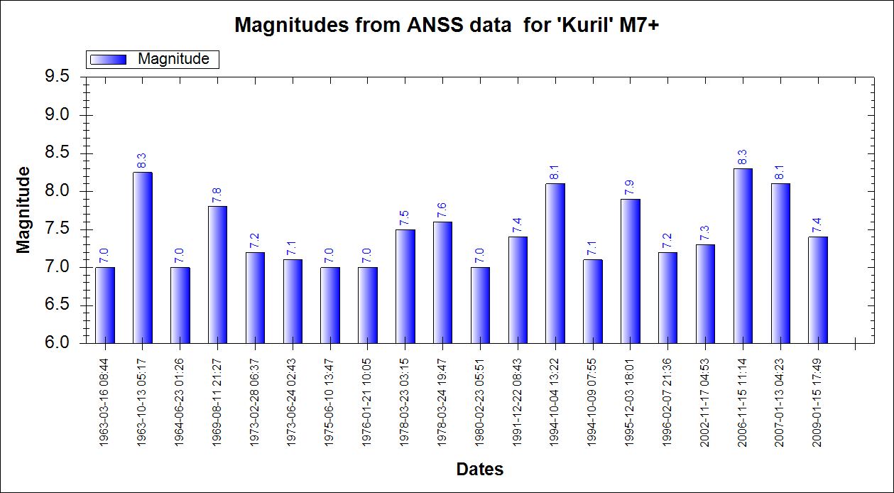
Data from ANSS (I run about 4 months behind on this so the latest is not in the list)
Prov,Date/Time UTC,Latitude,Longitude,Magnitude,Depth(Km),Location
ANSS,2009-01-15 17:49:39, 46.857, 155.154, 7.4, 36.0, East Of Kuril Isls.
ANSS,2007-01-13 04:23:21, 46.243, 154.524, 8.1, 10.0, East Of Kuril Isls.
ANSS,2006-11-15 11:14:13, 46.592, 153.266, 8.3, 10.0, Kuril Isls.
ANSS,2002-11-17 04:53:53, 47.824, 146.209, 7.3, 459.1, N.West Of Kuril Isls.
ANSS,1996-02-07 21:36:46, 45.324, 149.892, 7.2, 42.6, Kuril Isls.
ANSS,1995-12-03 18:01:08, 44.663, 149.300, 7.9, 33.0, Kuril Isls.
ANSS,1994-10-09 07:55:39, 43.905, 147.916, 7.1, 33.0, Kuril Isls.
ANSS,1994-10-04 13:22:55, 43.773, 147.321, 8.1, 14.0, Kuril Isls.
ANSS,1991-12-22 08:43:13, 45.533, 151.021, 7.4, 24.7, Kuril Isls.
ANSS,1980-02-23 05:51:03, 43.530, 146.753, 7.0, 44.0, Kuril Isls.
ANSS,1978-03-24 19:47:50, 44.244, 148.862, 7.6, 33.0, Kuril Isls.
ANSS,1978-03-23 03:15:20, 44.932, 148.439, 7.5, 33.0, Kuril Isls.
ANSS,1976-01-21 10:05:24, 44.915, 149.123, 7.0, 41.0, Kuril Isls.
ANSS,1975-06-10 13:47:14, 43.024, 147.734, 7.0, 15.0, Kuril Isls.
ANSS,1973-06-24 02:43:25, 43.318, 146.442, 7.1, 50.0, Kuril Isls.
ANSS,1973-02-28 06:37:49, 50.486, 156.584, 7.2, 27.0, Kuril Isls.
ANSS,1969-08-11 21:27:39, 43.545, 147.353, 7.8, 28.0, Kuril Isls.
ANSS,1964-06-23 01:26:37, 43.300, 146.100, 7.0, 77.0, Kuril Isls.
ANSS,1963-10-13 05:17:57, 44.800, 149.500, 8.2, 60.0, Kuril Isls.
ANSS,1963-03-16 08:44:51, 46.600, 154.800, 7.0, 46.0, East Of Kuril Isls.
And a chart of that

Man, I have not been very observant on the USGS map's page. Odds are this was already discussed, but I know I must have missed that convo.
They're going to replace a very useful map that I've finally learned to like with this? What the hell is that?!
If they were aiming to simplify, they ratcheted that goal up in to "overkill" mode o.O
This interface will be replaced by the new BETA Earthquake Map/List within the next few weeks.
They're going to replace a very useful map that I've finally learned to like with this? What the hell is that?!
If they were aiming to simplify, they ratcheted that goal up in to "overkill" mode o.O
reply to post by Nyiah
Make sure you do!
Actually I don't mind it, it will just be a case of getting used to it.
I like the Gray map, less clutter.
A quick trial of it seems to show the sliding times and magnitudes are the things missing and the downloads don't alter with the map if you zoom to a spot, which was handy.
This is a beta version, please send us feedback so we can keep improving!
Make sure you do!
Actually I don't mind it, it will just be a case of getting used to it.
I like the Gray map, less clutter.
A quick trial of it seems to show the sliding times and magnitudes are the things missing and the downloads don't alter with the map if you zoom to a spot, which was handy.
reply to post by PuterMan
Thanks for having a look anyway.
I googled Earthquake Travel Time Calculator and all there is is the broken USGS one, all the rest are too hard to understand.
The only way around this would be for me to check each event's USGS Technical page and get the arrival time at Wellington, New Zealand, its only the P wave though, and most of what shows on LISS SNZO is LR waves.
Damn.
new topics
-
What is the white pill?
Philosophy and Metaphysics: 31 minutes ago -
Mike Pinder The Moody Blues R.I.P.
Music: 1 hours ago -
Putin, Russia and the Great Architects of the Universe
ATS Skunk Works: 4 hours ago -
A Warning to America: 25 Ways the US is Being Destroyed
New World Order: 8 hours ago
top topics
-
President BIDEN's FBI Raided Donald Trump's Florida Home for OBAMA-NORTH KOREA Documents.
Political Conspiracies: 14 hours ago, 32 flags -
A Warning to America: 25 Ways the US is Being Destroyed
New World Order: 8 hours ago, 15 flags -
Is AI Better Than the Hollywood Elite?
Movies: 16 hours ago, 4 flags -
Mike Pinder The Moody Blues R.I.P.
Music: 1 hours ago, 3 flags -
What is the white pill?
Philosophy and Metaphysics: 31 minutes ago, 2 flags -
Maestro Benedetto
Literature: 16 hours ago, 1 flags -
Putin, Russia and the Great Architects of the Universe
ATS Skunk Works: 4 hours ago, 1 flags
active topics
-
President BIDEN's FBI Raided Donald Trump's Florida Home for OBAMA-NORTH KOREA Documents.
Political Conspiracies • 27 • : Threadbarer -
Meadows, Giuliani Among 11 Indicted in Arizona in Latest 2020 Election Subversion Case
Mainstream News • 18 • : IndieA -
A Warning to America: 25 Ways the US is Being Destroyed
New World Order • 20 • : jidnum2 -
Gaza Terrorists Attack US Humanitarian Pier During Construction
Middle East Issues • 62 • : CarlLaFong -
New whistleblower Jason Sands speaks on Twitter Spaces last night.
Aliens and UFOs • 69 • : Ophiuchus1 -
Putin, Russia and the Great Architects of the Universe
ATS Skunk Works • 16 • : CristianVictoria -
Alternate Electors vs Fake Electors - What is the Difference.
2024 Elections • 123 • : frogs453 -
Massachusetts Drag Queen Leads Young Kids in Free Palestine Chant
Social Issues and Civil Unrest • 17 • : ToneD -
Hate makes for strange bedfellows
US Political Madness • 51 • : network dude -
The Acronym Game .. Pt.3
General Chit Chat • 7755 • : F2d5thCavv2