It looks like you're using an Ad Blocker.
Please white-list or disable AboveTopSecret.com in your ad-blocking tool.
Thank you.
Some features of ATS will be disabled while you continue to use an ad-blocker.

Quake Watch 2013
page: 75share:
Originally posted by jazz3
do i dare type here? or will i get kicked for trying? dont tell the truth any where online u get banned or kicked.
grrrrrrrrrr tried to post a reply 3times at least. ran outa fingers.
Check you PM at the other place.
A couple Items
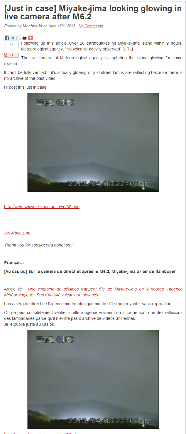
Miyake-jima looking glowing in live camera after M6.2
Posted by Mochizuki on April 17th, 2013

click thumbnail
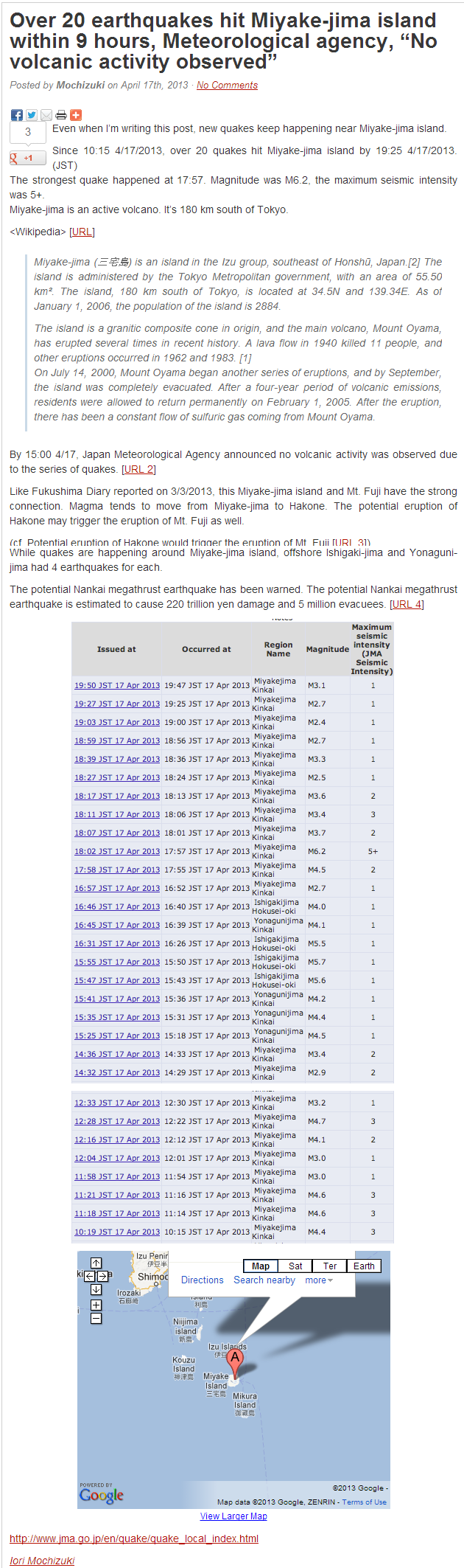
Over 20 earthquakes hit Miyake-jima island within 9 hours, Meteorological agency, “No volcanic activity observed”
Posted by Mochizuki on April 17th, 2013

click thumbnail
fukushima-diary.com...
edit on 4/17/2013 by this_is_who_we_are because: typo
reply to post by this_is_who_we_are
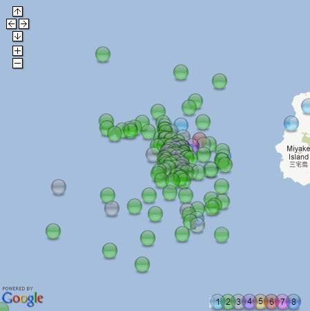
I don't mean to contradict you, Mochizuki or JMA, but NIED are showing a lot more aftershocks than that for the 6.3ML
click on the map for the interactive version of the whole of Japan for Apr 17-18th UTC
the 6.1 of Oshika, Honshu is only showing 2 aftershocks
I don't mean to contradict you, Mochizuki or JMA, but NIED are showing a lot more aftershocks than that for the 6.3ML
click on the map for the interactive version of the whole of Japan for Apr 17-18th UTC
the 6.1 of Oshika, Honshu is only showing 2 aftershocks
edit on 17-4-2013 by muzzy because: (no reason given)
reply to post by dreamfox1
Perhaps before I start I had better mention that I do not intend to be rude or aggressive despite the fact that my manner sometimes comes across as such
In this post I went to great pains to explain the Ionospheric TEC maps and how they are ground based estimates of TEC. Please do read the post before continuing.
Now I am happy to be proved wrong, but as I said in the post I find no correlation between high TEC and earthquakes USING THIS METHOD. That part is important as I pointed out in the post.
You do not of course have any obligation to believe this old goat but I did put a lot of effort into that conclusion, even to using the server of a company in England to ensure I got 24/7 coverage of the 5 minute images for well over a year.
May I suggest that if you still think there is a correlation other than happenstance that you perform a similar exercise and check the TEC against all major earthquakes as they occur? Only that way can you then confidently state that the TEC affects the earthquakes.
There is another course you could pursue as well, which I have not looked at, which is this:
The area where TEC is highest is when the atmosphere is receiving direct insolation, in other words when the Sun is facing the area. It should be relatively simple to take say the Centennial catalogue and see if there is a high correlation between overhead Sun and time of earthquake.
Actually it would be very much appreciated if you could do such and exercise as the results could be very interesting and may prove your point where I failed.
New danger zone is at the French Polynesia and Cook Islands for a medium to large quake. (South Pacific Ocean)
Ionospheric Map is showing that area at the 13 mhz range.
Pakistan region was at 16 mhz when the 7.8 quake happened.
Perhaps before I start I had better mention that I do not intend to be rude or aggressive despite the fact that my manner sometimes comes across as such
In this post I went to great pains to explain the Ionospheric TEC maps and how they are ground based estimates of TEC. Please do read the post before continuing.
Now I am happy to be proved wrong, but as I said in the post I find no correlation between high TEC and earthquakes USING THIS METHOD. That part is important as I pointed out in the post.
You do not of course have any obligation to believe this old goat but I did put a lot of effort into that conclusion, even to using the server of a company in England to ensure I got 24/7 coverage of the 5 minute images for well over a year.
May I suggest that if you still think there is a correlation other than happenstance that you perform a similar exercise and check the TEC against all major earthquakes as they occur? Only that way can you then confidently state that the TEC affects the earthquakes.
There is another course you could pursue as well, which I have not looked at, which is this:
The area where TEC is highest is when the atmosphere is receiving direct insolation, in other words when the Sun is facing the area. It should be relatively simple to take say the Centennial catalogue and see if there is a high correlation between overhead Sun and time of earthquake.
Actually it would be very much appreciated if you could do such and exercise as the results could be very interesting and may prove your point where I failed.
Originally posted by Lothbrok
My eyes are on the SW Ryukyu Islands. Many shallow quakes.
Better would be Senkaku and then disappear in the ocean
edit on 18-4-2013 by aLLeKs because: (no reason given)
3.0: M
6km ESE of Waikoloa, Hawaii: Location
2013-04-18 10:46:21: Date/Time
19.911°N: Lat
155.738°W: Lon
32.1: D
Can anyone tell me if the frequency of EQ activity in Hawaii in the last 7 days, is run-of-the-mill
for the state?
I realize Hawaii is basically a string of volcanoes. It just seems very active this last 7 days to me
edit on 18-4-2013 by azureskys
because: spelling
edit on 18-4-2013 by azureskys because: spelling correction
I have a serious question since it concerns me a lot.
As some of you know my girlfriend is living in Osaka. She called me today and said, that the news yesterday where full of reports that scientists are expecting a M7 or higher one in the Kansai area soon.
Does anybody have some information on this one?
I mean M7 or more would be really devastating in this area.
It's a tiddler, but how often do you see this on a USGS event?
M2.1 - Quarry Blast 1km WSW of Kinnelon, New Jersey
The normal import I use just says New Jersey, but the new one I am testing uses the names as per the interactive site so I spotted it.
M2.1 - Quarry Blast 1km WSW of Kinnelon, New Jersey
The normal import I use just says New Jersey, but the new one I am testing uses the names as per the interactive site so I spotted it.
reply to post by aLLeKs
This site may be of interest to you, but it does not answer your question unfortunately.
Biggest Earthquakes Near Osaka, Japan
ETA: Found another that might be very relevant. It is a PDF file
Part 1: Long-period ground motion prediction in the Osaka basin for future Nankai Earthquakes
I searched for - Magnitude 7 Osaka prediction - so you may find more using that phrase as I have only got to Page 2 of about 6,120,000 results (0.15 seconds) !!
A lot of info in this one
This site may be of interest to you, but it does not answer your question unfortunately.
Biggest Earthquakes Near Osaka, Japan
ETA: Found another that might be very relevant. It is a PDF file
Osaka, one of Japan's largest cities, has repeatedly suffered from disasters due to huge subduction earthquakes of magnitude greater than eight occurring along the Nankai Trough. The probability of earthquake reoccurrence within 30 years from January 1, 2008 is very high and estimated at 60–70% and 50% for the next Tonankai and Nankai earthquakes, respectively.
Part 1: Long-period ground motion prediction in the Osaka basin for future Nankai Earthquakes
I searched for - Magnitude 7 Osaka prediction - so you may find more using that phrase as I have only got to Page 2 of about 6,120,000 results (0.15 seconds) !!
edit on 18/4/2013 by PuterMan because: (no reason given)
A lot of info in this one
edit on 18/4/2013 by PuterMan because: (no reason given)
7.0 just now near Kuril Islands
earthquake.usgs.gov...
earthquake.usgs.gov...
edit on 01/04/2009 by steve95988 because: (no reason given)
Originally posted by steve95988
7.0 just now near Kuril Islands
earthquake.usgs.gov...edit on 01/04/2009 by steve95988 because: (no reason given)
Type: Earthquake
Magnitude: 7.2
DateTime: Friday April 19 2013, 03:05:53 UTC
Region: Kuril Islands
Depth: 122.3 km
Source: USGS Feed
edit on 7/30/2012 by dreamfox1 because: earthquake.usgs.gov...
t'Internet off again from 2100 UTC last night until now. Must put up a note reminding myself why I love rural Ireland so. (Scenery and
craic)
So I said there would be 2 x mag 7 on April 21 at Vanuatu. In line with most prediction sites I claim a success in that there have been two, even if I got the dates and places wrong. I should have been more mysterious and said 2 major earthquakes on or around the 18th April.
I hope the 21st is not still on!
reply to post by PuterMan
hi any data on the latest quake at Japan?
7.0 or so I just read...
by the way, I am not being lazy, just wanted to leave it to the experts
hi any data on the latest quake at Japan?
7.0 or so I just read...
by the way, I am not being lazy, just wanted to leave it to the experts
reply to post by Thurisaz
www.news.com.au...
Magnitude 7.0 earthquake off Japan in Kuril Islands From: News Limited Network
Read more: www.news.com.au...
www.news.com.au...
Magnitude 7.0 earthquake off Japan in Kuril Islands From: News Limited Network
April 19, 2013 4:07PM
A 7.0-magnitude earthquake has struck in seas off far northern Japan and far eastern Russiabut but no damage was expected.
The Japan Meteorological Agency said sea changes were possible. No tsunami warnings have been issued.
The tremor struck around midday in the Pacific Ocean at a relatively shallow depth of 10 kilometres. The US Geological Survey measured a stronger 7.2 magnitude.
Japan and Russia both claim some of the sparsely populated islands in the remote region.
The epicentre was 58 kilometres east-northeast of Kuril'sk, Russia, and 528 kilometres northeast of Nemuro, Japan.
The nearest land is the volcanic islands of Urup, Iturup and Sumushir. Hokkaido officials said the islands were not under Japanese control.
The area is about 1,500 kilometres northeast of Tokyo.
The quake was felt in Hokkaido and much of the northern island of Japan. It was also reportedly felt in Tokyo.
"We have received no reports of damage so far," a spokesman at the Hokkaido police said, adding there were no reports
Read more: www.news.com.au...
6.1 Incoming - Timor
www.emsc-csem.org...
GFZ have 6.0
Oh well. USGS and EMSC have given it a discount to 5.8
earthquake.usgs.gov...
GFZ still at 6.0
And just to make me look even more stupid GFZ now have 5.7
It was over Mag 6 Guvn'r 'onest it were.
Magnitude M 6.1
Region SOUTH OF TIMOR
Date time 2013-04-19 17:51:41.0 UTC
Location 12.14 S ; 121.58 E
Depth 10 km
Distances 590 km SW of Dili, East Timor / pop: 150,000 / local time: 02:51:41.0 2013-04-20
309 km SW of Kupang, Indonesia / pop: 282,396 / local time: 01:51:41.0 2013-04-20
www.emsc-csem.org...
GFZ have 6.0
Oh well. USGS and EMSC have given it a discount to 5.8
earthquake.usgs.gov...
GFZ still at 6.0
And just to make me look even more stupid GFZ now have 5.7
It was over Mag 6 Guvn'r 'onest it were.
edit on 19/4/2013 by PuterMan because: (no reason given)
edit on 19/4/2013 by PuterMan because: (no reason given)
6.1 incoming. Kuril Islands. Aftershock
www.emsc-csem.org...
Location in Google Maps
Derived from Event Data Source: USGS
Powered by QVSData
GFZ have 6.4 and that has been manually revised.
geofon.gfz-potsdam.de...
www.emsc-csem.org...
Magnitude 6.0 - East Of The Kuril Islands
Location in Google Maps
- Date-Time: Friday, April 19, 2013 @ 19:58:38 UTC
- Earthquake location: 49.968°N, 157.626°E,
- Earthquake depth: 1.0 km
- Distances:
132km (82mi) SE of Severo-Kuril'sk, Russia
334km (207mi) S of Vilyuchinsk, Russia
349km (216mi) SSW of Petropavlovsk-Kamchatskiy, Russia
362km (224mi) S of Yelizovo, Russia
2148km (1334mi) NE of Tokyo, Japan
- Event ID: usb000gc6m
Derived from Event Data Source: USGS
Powered by QVSData
GFZ have 6.4 and that has been manually revised.
geofon.gfz-potsdam.de...
edit on 19/4/2013 by PuterMan because: (no reason given)
Geez its getting hard to keep up, I'm having to download LISS SNZO graph 3 times a day
GFZ have
ha they had a look at it already
6.4 50.09°N 157.54°E 10 A ,
insert
6.4 49.95°N 157.54°E 16 M
GFZ have
2013-04-19 19:58:40 6.4 50.09°N 157.54°E 10 A Kuril Islands
2013-04-19 17:51:41 5.8 12.06°S 121.58°E 10 C MT South of Timor, Indonesia
ha they had a look at it already
insert
6.4 49.95°N 157.54°E 16 M
edit on 19-4-2013 by muzzy because: (no reason given)
Originally posted by PuterMan
6.1 Incoming - Timor
GFZ still at 6.0
And just to make me look even more stupid GFZ now have 5.7
It was over Mag 6 Guvn'r 'onest it were.
I believe you, as I marked 6 on the title of the LISS SNZO I saved just a few hours ago
edit on 19-4-2013 by muzzy because: (no reason
given)
new topics
-
Where should Trump hold his next rally
Politicians & People: 2 minutes ago -
Shocking Number of Voters are Open to Committing Election Fraud
US Political Madness: 46 minutes ago -
Gov Kristi Noem Shot and Killed "Less Than Worthless Dog" and a 'Smelly Goat
2024 Elections: 1 hours ago -
Falkville Robot-Man
Aliens and UFOs: 1 hours ago -
James O’Keefe: I have evidence that exposes the CIA, and it’s on camera.
Whistle Blowers and Leaked Documents: 2 hours ago -
Australian PM says the quiet part out loud - "free speech is a threat to democratic dicourse"...?!
New World Order: 3 hours ago -
Ireland VS Globalists
Social Issues and Civil Unrest: 3 hours ago -
Biden "Happy To Debate Trump"
2024 Elections: 4 hours ago -
RAAF airbase in Roswell, New Mexico is on fire
Aliens and UFOs: 4 hours ago -
What is the white pill?
Philosophy and Metaphysics: 5 hours ago
top topics
-
A Warning to America: 25 Ways the US is Being Destroyed
New World Order: 14 hours ago, 21 flags -
Blast from the past: ATS Review Podcast, 2006: With All Three Amigos
Member PODcasts: 6 hours ago, 11 flags -
Mike Pinder The Moody Blues R.I.P.
Music: 6 hours ago, 8 flags -
Biden "Happy To Debate Trump"
2024 Elections: 4 hours ago, 8 flags -
James O’Keefe: I have evidence that exposes the CIA, and it’s on camera.
Whistle Blowers and Leaked Documents: 2 hours ago, 5 flags -
What is the white pill?
Philosophy and Metaphysics: 5 hours ago, 5 flags -
Australian PM says the quiet part out loud - "free speech is a threat to democratic dicourse"...?!
New World Order: 3 hours ago, 5 flags -
Ireland VS Globalists
Social Issues and Civil Unrest: 3 hours ago, 4 flags -
RAAF airbase in Roswell, New Mexico is on fire
Aliens and UFOs: 4 hours ago, 4 flags -
Putin, Russia and the Great Architects of the Universe
ATS Skunk Works: 9 hours ago, 3 flags
active topics
-
This is our Story
General Entertainment • 2 • : ByeByeAmericanPie -
Mike Pinder The Moody Blues R.I.P.
Music • 2 • : DontTreadOnMe -
University of Texas Instantly Shuts Down Anti Israel Protests
Education and Media • 299 • : CriticalStinker -
Where should Trump hold his next rally
Politicians & People • 0 • : charlest2 -
Candidate TRUMP Now Has Crazy Judge JUAN MERCHAN After Him - The Stormy Daniels Hush-Money Case.
Political Conspiracies • 806 • : Annee -
The functionality of boldening and italics is clunky and no post char limit warning?
ATS Freshman's Forum • 14 • : Encia22 -
MULTIPLE SKYMASTER MESSAGES GOING OUT
World War Three • 99 • : cherokeetroy -
Gov Kristi Noem Shot and Killed "Less Than Worthless Dog" and a 'Smelly Goat
2024 Elections • 25 • : FlyersFan -
Falkville Robot-Man
Aliens and UFOs • 4 • : Kurokage -
Shocking Number of Voters are Open to Committing Election Fraud
US Political Madness • 1 • : YourFaceAgain