It looks like you're using an Ad Blocker.
Please white-list or disable AboveTopSecret.com in your ad-blocking tool.
Thank you.
Some features of ATS will be disabled while you continue to use an ad-blocker.

Quake Watch 2013
page: 50share:
I always open my eyes when anything around a 5.0 or greater is in this subduction zone... one day is coming... when the west coast will suffer
greatly
This event has been reviewed by a seismologist.
Magnitude 5.1
Date-Time
Wednesday, February 27, 2013 at 22:25:44 UTC
Wednesday, February 27, 2013 at 02:25:44 PM at epicenter
Time of Earthquake in other Time Zones
Location 43.152°N, 126.467°W
Depth 9.9 km (6.2 miles)
Region OFF THE COAST OF OREGON
Distances 167 km (103 miles) W of Bandon, Oregon
184 km (114 miles) W of Coos Bay, Oregon
254 km (157 miles) W of Roseburg, Oregon
268 km (166 miles) WNW of Grants Pass, Oregon
Location Uncertainty horizontal +/- 19.4 km (12.1 miles); depth +/- 4.5 km (2.8 miles)
Parameters NST=180, Nph=181, Dmin=177 km, Rmss=0.87 sec, Gp=158°,
M-type=body wave magnitude (Mb), Version=7
Source
Magnitude: USGS NEIC (WDCS-D)
Location: USGS NEIC (WDCS-D)
Event ID usc000fe5b
earthquake.usgs.gov...
reply to post by muzzy
Ha, I don't remember when it last did whatever the H is the opposite of rained - I have forgotten what that is.
And, as i suspected, and after the 7 days period has passed New Zealand has been downgraded to 5.9
Downgraded quake
mag=5.9|place=111km NE of LEsperance Rock. New Zealand
earthquake.usgs.gov...
On my quake watch site I said
I have to say that I am not happy with this one at 6.1. I believe it should be under Mag 6
Now it is and PuterMan is happy again!
reply to post by radpetey
A good read
"There was a 9.0 earthquake when the Europeans occupied the island on December 2, 1562. It destroyed the cities of La Vega and Santiago. A quake estimated to be a 10.0 happened on October 18, 1751 and devastated the southern region. A terremoto estimated to be 11.0 happened on May 7, 1842 destroyed the north of Haiti and much of what is now the Dominican Republic."
I think Utsu would have picked up on those, when he was working on the papers he took over he considered all folklore and such stuff.
I'll have a look and see if there is anything for those dates. They may have been a mag 6.5 or something, but lots of peoples killed making it seem worse than it really was size wise
F-E Region: Vanuatu Islands
Time: 2013-02-28 03:09:44.5 UTC
Magnitude: 6.0
Epicenter: 167.35°E 17.67°S
Depth: 10 km
Status: A - automatic
geofon.gfz-potsdam.de...
reply to post by muzzy
Und nun die Seismologen geschaut hat, und dies ist nicht eine Stärke 6
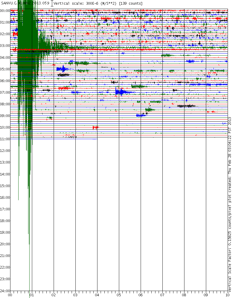
But the dear old USGS (you have to love them NOT) still insist it is a Mag 6.1mb. This is despite that fact that they say 5.8Mw and 5.9Mw on the tensor solutions. As with New Zealand I have no doubt this will go down to 5.9 once the proprietary 8 days has passed. I am so convinced of this I am not even going to bother to amend my site to show it.
You gotta admit the accelerometer image of it is pretty!
Und nun die Seismologen geschaut hat, und dies ist nicht eine Stärke 6
F-E Region: Vanuatu Islands
Mw Beach Ball
Time: 2013-02-28 03:09:44.6 UTC
Magnitude: 5.9 (Mw)
Epicenter: 167.37°E 17.71°S
Depth: 19 km
Status: M - manually revised
But the dear old USGS (you have to love them NOT) still insist it is a Mag 6.1mb. This is despite that fact that they say 5.8Mw and 5.9Mw on the tensor solutions. As with New Zealand I have no doubt this will go down to 5.9 once the proprietary 8 days has passed. I am so convinced of this I am not even going to bother to amend my site to show it.
You gotta admit the accelerometer image of it is pretty!

edit on 28/2/2013 by PuterMan because: To add an image.
Magnitude 6.9 - Kuril Islands
L ocation in Google Maps
- Date-Time: Thursday, February 28, 2013 @ 14:05:51 UTC
- Earthquake location: 50.753°N, 157.532°E,
- Earthquake depth: 46.3 km
- Distances:
101km (62mi) E of Severo-Kuril'sk, Russia
242km (150mi) SSW of Vilyuchinsk, Russia
259km (160mi) SSW of Petropavlovsk-Kamchatskiy, Russia
269km (167mi) SSW of Yelizovo, Russia
2207km (1371mi) NE of Tokyo, Japan
- Event ID: pt13059001
Derived from Event Data Source: USGS
Powered by QVSData
I guess it had to pop another off before the end of the month
000
WEPA42 PHEB 281413
TIBPAC
TSUNAMI BULLETIN NUMBER 001
PACIFIC TSUNAMI WARNING CENTER/NOAA/NWS
ISSUED AT 1413Z 28 FEB 2013
THIS BULLETIN APPLIES TO AREAS WITHIN AND BORDERING THE PACIFIC
OCEAN AND ADJACENT SEAS...EXCEPT ALASKA...BRITISH COLUMBIA...
WASHINGTON...OREGON AND CALIFORNIA.
... TSUNAMI INFORMATION BULLETIN ...
THIS BULLETIN IS FOR INFORMATION ONLY.
THIS BULLETIN IS ISSUED AS ADVICE TO GOVERNMENT AGENCIES. ONLY
NATIONAL AND LOCAL GOVERNMENT AGENCIES HAVE THE AUTHORITY TO MAKE
DECISIONS REGARDING THE OFFICIAL STATE OF ALERT IN THEIR AREA AND
ANY ACTIONS TO BE TAKEN IN RESPONSE.
AN EARTHQUAKE HAS OCCURRED WITH THESE PRELIMINARY PARAMETERS
ORIGIN TIME - 1406Z 28 FEB 2013
COORDINATES - 50.8 NORTH 157.5 EAST
DEPTH - 46 KM
LOCATION - KURIL ISLANDS
MAGNITUDE - 6.9
EVALUATION
NO DESTRUCTIVE WIDESPREAD TSUNAMI THREAT EXISTS BASED ON
HISTORICAL EARTHQUAKE AND TSUNAMI DATA.
HOWEVER - EARTHQUAKES OF THIS SIZE SOMETIMES GENERATE LOCAL
TSUNAMIS THAT CAN BE DESTRUCTIVE ALONG COASTS LOCATED WITHIN
A HUNDRED KILOMETERS OF THE EARTHQUAKE EPICENTER. AUTHORITIES
IN THE REGION OF THE EPICENTER SHOULD BE AWARE OF THIS
POSSIBILITY AND TAKE APPROPRIATE ACTION.
THIS WILL BE THE ONLY BULLETIN ISSUED FOR THIS EVENT UNLESS
ADDITIONAL INFORMATION BECOMES AVAILABLE.
THE JAPAN METEOROLOGICAL AGENCY MAY ALSO ISSUE TSUNAMI MESSAGES
FOR THIS EVENT TO COUNTRIES IN THE NORTHWEST PACIFIC AND SOUTH
CHINA SEA REGION. IN CASE OF CONFLICTING INFORMATION... THE
MORE CONSERVATIVE INFORMATION SHOULD BE USED FOR SAFETY.
THE WEST COAST/ALASKA TSUNAMI WARNING CENTER WILL ISSUE PRODUCTS
FOR ALASKA...BRITISH COLUMBIA...WASHINGTON...OREGON...CALIFORNIA.
Japan - No advisories in effect
www.jma.go.jp...
Emsc: M5.9
Potsdam: M5.8
edit on 28/2/2013 by PuterMan because: (no reason given)
reply to post by PuterMan
I don.t have a link to show it properly, but it seems that quake set off something in the Cali region.
USGS isn.t showing all the little ones going off.
I just find soooo interesting to see other area's react. Hoping of course nothing big happens.
I'm sorry I can't get the link to work for me.
I don.t have a link to show it properly, but it seems that quake set off something in the Cali region.
USGS isn.t showing all the little ones going off.
I just find soooo interesting to see other area's react. Hoping of course nothing big happens.
I'm sorry I can't get the link to work for me.
edit on 28-2-2013 by crappiekat because: (no reason given)
edit on 28-2-2013 by crappiekat because: Trying to add
link
further to post by muzzy
yeah quite a few with no magnitude, but severe damage;
yeah quite a few with no magnitude, but severe damage;
Date, Latitude, Longitude, Tidal waves, Damage, Where, Dead
1502/- /-, 18.3, -69.5, , - , seve, Dominica:Santo Domingo
1564/4/20, 19.1, -70.3, , - , seve, Dominica:Concepcion de la Vega
1615/9/8, -, - , , - , seve, Puerto Rico/Dominica:Santo Domingo
1673/5/9, 18.3, -69.5, , seve, Dominica:Santo Domingo, 5
1684/- /-, 19, -71, , - , seve, Dominica:Santo Domingo,Azua
1691/- /-, 18.3, -70.4, , - , seve, Haiti/Dominica:Azua,St.Domingo
1751/8/18, 19, -70, , - , seve, Dominica
1751/10/18, 18.5, -70.7, T, - , seve, Dominica:Santo Domingo,Azua
1771/10/3, -, - , , - , some, Dominica:Santo Domingo
1776/1/30, 19, -70.4, , - , seve, Dominica/Puerto Rico
1783/- /-, 19.3, -70.4, , - , mode, Dominica:santiago de Los Caballieros
1784/7/29, 18.3, -72.5, , - , seve, Dominica/Haiti:St.Domingo,Port-au-Prince,Goave
1793/- /-, -, - , , - , some, Dominica:Santo Domingo
1818/11/20, -, - , , - , some, Dominica:Cap Henri(Santo Domingo)
1842/5/7, 19.7, -72.8, T, seve, Dominica:St.Domingo,Santiago/Haiti,4500
source: Utsu search
reply to post by PuterMan
RAS are showing
but I'm not convinced its as high as 7, based on LISS, particularly SNZO, the graph should be 80% covered in wiggles for a 7+, no matter where it is in the World.
LDEO are quite low, at 6.7Ms
here is a 6.6 in the Kurils on 16/11/2012 for comparison although it is split by the graph borders, but you can clearly see todays was bigger than that
RAS are showing
Date [GMT] lat lon depth Ms mb region name
2013-02-28 14:05:48.5 50.87 157.41 50 [color=violet]7.0Ms/19 6.7mb/8 Kuril Islands
but I'm not convinced its as high as 7, based on LISS, particularly SNZO, the graph should be 80% covered in wiggles for a 7+, no matter where it is in the World.
LDEO are quite low, at 6.7Ms
here is a 6.6 in the Kurils on 16/11/2012 for comparison although it is split by the graph borders, but you can clearly see todays was bigger than that
edit on 28-2-2013 by muzzy because: (no reason
given)
Activity once again on the rise it seems to me this morning.
earthquake.usgs.gov...
It seems (to me ) that when Vanuatu cracks, others get perturbed. Maybe its me.... and the heebie geeebies I feel when I see this area, but I have noticed a pattern.
earthquake.usgs.gov...
MAP 6.5 2013/03/01 12:53:52 50.938 157.511 40.9 KURIL ISLANDS
MAP 4.0 2013/03/01 07:50:23 42.561 -111.087 4.7 SOUTHERN IDAHO
It seems (to me ) that when Vanuatu cracks, others get perturbed. Maybe its me.... and the heebie geeebies I feel when I see this area, but I have noticed a pattern.
edit on 1-3-2013 by MamaJ because: (no reason given)
reply to post by muzzy
Muzzy, as I see and feel it, I don't think Japan or Cali is going to get much warning. Once the chain reaction starts it will move so fast, both the EQs and the Tsunamis. The pressure is building on the west coast and the plate is opening on Japan Russia side.
The 11th or 12 seems like it could be a repeat. Last year was the warning.
edit on 1-3-2013 by prophetboy12 because: added some
thoughts
update on post by muzzy
NIED (reviewed)
6.3ML, 2013/02/25 16:23:53, 36.874N, 139.413E, 2.8km, NORTHERN TOCHIGI PREF
was
NIED preliminary (first)
5.5ML 25/02/2013 16:23:53, 36.8731 139.4069, 2.1 km, Nikko,Tochigi Prefecture
AQUA and JMA unchanged at 5.8Mw and 6.2ML respectively
NIED (reviewed)
6.3ML, 2013/02/25 16:23:53, 36.874N, 139.413E, 2.8km, NORTHERN TOCHIGI PREF
was
NIED preliminary (first)
5.5ML 25/02/2013 16:23:53, 36.8731 139.4069, 2.1 km, Nikko,Tochigi Prefecture
AQUA and JMA unchanged at 5.8Mw and 6.2ML respectively
edit on 1-3-2013 by muzzy because: (no reason given)
reply to post by prophetboy12
The 11th or 12 seems like it could be a repeat. Last year was the warning.
Do you mind being more specific? A repeat of last year? What specifically are you speaking of that happened last year? Why do you think the 11th or 12th? Why not tomorrow? Just curious.
USGS (currently)
6.5, 2013/03/01 13:20:51, 50.945, 157.476, 31.7, KURIL ISLANDS
6.5, 2013/03/01 12:53:52, 50.938, 157.511, 40.9, KURIL ISLANDS
EMSC
6.5, 2013-03-01 13:20:52.0, 50.92N,157.53E, 50, KURIL ISLANDS
6.3, 2013-03-01 12:53:54.0, 50.97N,157.56E, 56, KURIL ISLANDS
GFZ
6.5, 2013-03-01 13:20:52, 50.80°N 157.68°E, 55, Kuril Islands
6.3, 2013-03-01 12:53:54, 50.88°N 157.56°E, 57, Kuril Islands
RAS
6.7Ms/16 6.2mb/23, 2013-03-01 13:20:51.3, 50.88, 157.61, 60, Kuril Islands
6.4Ms/13 6.0mb/14, 2013-03-01 12:53:51.8, 50.88, 157.58, 60, Kuril Islands
LDEO
6.4Ms, 2013/ 3/ 1 13: 20: 56.0, 51.25, 157.25, 33.0, NEAR EAST COAST OF KAMCHATKA
6.3Ms,2013/ 3/ 1 12: 53: 52.0, 51.00, 157.00, 33.0, NEAR EAST COAST OF KAMCHATKA
Its pretty obvious USGS are struggling with these, its clear they are a different size from LISS SNZO (the first one is on the right of the graph)
just had a look at the MTS's on USGS, seem to be more in line with the consensus
USGS Body-Wave Moment Tensor Solution
6.4Mw, 13/03/01 13:20:49.96, 50.838, 157.632, 35, KURIL ISLANDS
6.3Mw, 13/03/01 12:53:51.45, 50.922, 157.510, 35, KURIL ISLANDS
USGS WPhase Moment Solution
6.5Mw, 13/03/01 13:20:50.00, 50.944,157.475, 40, KURIL ISLANDS
6.4Mw,13/03/01 12:53:52.00, 50.838, 157.670, 40, KURIL ISLANDS
...... and
USGS Energy and Broadband Solution
Me 6.3, 13/03/01 13:20:50, 50.94N, 157.48E, 29, KURIL ISLANDS
Me 5.5, 13/03/01 12:53:52, 50.94N, 157.51E, 33, KURIL ISLANDS
6.5, 2013/03/01 13:20:51, 50.945, 157.476, 31.7, KURIL ISLANDS
6.5, 2013/03/01 12:53:52, 50.938, 157.511, 40.9, KURIL ISLANDS
EMSC
6.5, 2013-03-01 13:20:52.0, 50.92N,157.53E, 50, KURIL ISLANDS
6.3, 2013-03-01 12:53:54.0, 50.97N,157.56E, 56, KURIL ISLANDS
GFZ
6.5, 2013-03-01 13:20:52, 50.80°N 157.68°E, 55, Kuril Islands
6.3, 2013-03-01 12:53:54, 50.88°N 157.56°E, 57, Kuril Islands
RAS
6.7Ms/16 6.2mb/23, 2013-03-01 13:20:51.3, 50.88, 157.61, 60, Kuril Islands
6.4Ms/13 6.0mb/14, 2013-03-01 12:53:51.8, 50.88, 157.58, 60, Kuril Islands
LDEO
6.4Ms, 2013/ 3/ 1 13: 20: 56.0, 51.25, 157.25, 33.0, NEAR EAST COAST OF KAMCHATKA
6.3Ms,2013/ 3/ 1 12: 53: 52.0, 51.00, 157.00, 33.0, NEAR EAST COAST OF KAMCHATKA
Its pretty obvious USGS are struggling with these, its clear they are a different size from LISS SNZO (the first one is on the right of the graph)
edit on 1-3-2013 by muzzy because: (no reason given)
just had a look at the MTS's on USGS, seem to be more in line with the consensus
USGS Body-Wave Moment Tensor Solution
6.4Mw, 13/03/01 13:20:49.96, 50.838, 157.632, 35, KURIL ISLANDS
6.3Mw, 13/03/01 12:53:51.45, 50.922, 157.510, 35, KURIL ISLANDS
USGS WPhase Moment Solution
6.5Mw, 13/03/01 13:20:50.00, 50.944,157.475, 40, KURIL ISLANDS
6.4Mw,13/03/01 12:53:52.00, 50.838, 157.670, 40, KURIL ISLANDS
...... and
USGS Energy and Broadband Solution
Me 6.3, 13/03/01 13:20:50, 50.94N, 157.48E, 29, KURIL ISLANDS
Me 5.5, 13/03/01 12:53:52, 50.94N, 157.51E, 33, KURIL ISLANDS
edit on 1-3-2013 by muzzy because: add some more data
M4.4 - 54km E of Searles Valley, California
Event Page
Event Time
2013-03-01 21:55:27 UTC
2013-03-01 13:55:27 UTC-08:00 at epicenter
2013-03-01 14:55:27 UTC-07:00 system time
Location
35.820°N 116.803°W depth=0.3km (0.2mi)
Nearby Cities
54km (34mi) E of Searles Valley, California
81km (50mi) ENE of Ridgecrest, California
85km (53mi) WSW of Pahrump, Nevada
104km (65mi) N of Barstow, California
454km (282mi) SE of Carson City, Nevada
reply to post by MamaJ
Days correspond to numbers, numbers correspond to lines of the clock, lines of the clock correspond to angles, angles correspond to energies, energies correspond to light, light corresponds to vibration, vibration corresponds to color, color corresponds to virtue, virtue corresponds to dispensation, dispensation corresponds to cosmic direction, cosmic direction corresponds to cosmic plan, cosmic plan correlates to cosmic being, cosmic being corresponds to universal plan.
11 is 11 o'clock line. Physical quadrant. Last line before new quadrant. The sun would be in the center of the clock. It is the slingshot of energy of the cosmic beings directing the universe.
I know that this all sounds like gobble gook, but the energy that comes from the sun is not only intelligence driven it is a reflection of us. Are we intelligent?
2 shakes, not many seconds apart in the D.R:
4.3 13km S of Rio San Juan, Dominican Republic 2013-03-02 03:17:40 19.521°N 70.065°W 41.3
4.1 15km WNW of El Factor, Dominican Republic 2013-03-02 03:17:16 19.366°N 70.026°W 28.7
earthquake.usgs.gov...
(That link SHOULD work, I hope. I had to cut it down, it was a million miles long for some reason today)
reply to post by Nyiah
must be the day for double taps, seen these as well on GFZ, minutes apart though, rather than seconds
thats deep for Santa Cruz
must be the day for double taps, seen these as well on GFZ, minutes apart though, rather than seconds
Time, Mag, Lat, Long, Depth, Status, Where
2013-03-02 19:29:13 4.4 32.71°N 50.72°E 10 M Northern and Central Iran
2013-03-02 19:24:28 4.6 31.88°N 50.86°E 11 M Northern and Central Iran
2013-03-02 01:19:37 5.0 12.91°S 169.20°E 640 A Santa Cruz Islands Region
2013-03-02 01:17:58 4.9 12.82°S 169.18°E 637 A Santa Cruz Islands Region
source
thats deep for Santa Cruz
edit on 2-3-2013 by muzzy because: (no reason given)
new topics
-
Australian PM says the quiet part out loud - "free speech is a threat to democratic dicourse"...?!
New World Order: 14 minutes ago -
Ireland VS Globalists
Social Issues and Civil Unrest: 45 minutes ago -
Biden "Happy To Debate Trump"
Mainstream News: 1 hours ago -
RAAF airbase in Roswell, New Mexico is on fire
Aliens and UFOs: 1 hours ago -
What is the white pill?
Philosophy and Metaphysics: 2 hours ago -
Mike Pinder The Moody Blues R.I.P.
Music: 3 hours ago -
Putin, Russia and the Great Architects of the Universe
ATS Skunk Works: 6 hours ago -
A Warning to America: 25 Ways the US is Being Destroyed
New World Order: 11 hours ago
top topics
-
President BIDEN's FBI Raided Donald Trump's Florida Home for OBAMA-NORTH KOREA Documents.
Political Conspiracies: 16 hours ago, 35 flags -
A Warning to America: 25 Ways the US is Being Destroyed
New World Order: 11 hours ago, 20 flags -
Mike Pinder The Moody Blues R.I.P.
Music: 3 hours ago, 7 flags -
What is the white pill?
Philosophy and Metaphysics: 2 hours ago, 5 flags -
Biden "Happy To Debate Trump"
Mainstream News: 1 hours ago, 5 flags -
RAAF airbase in Roswell, New Mexico is on fire
Aliens and UFOs: 1 hours ago, 4 flags -
Putin, Russia and the Great Architects of the Universe
ATS Skunk Works: 6 hours ago, 3 flags -
Ireland VS Globalists
Social Issues and Civil Unrest: 45 minutes ago, 2 flags -
Australian PM says the quiet part out loud - "free speech is a threat to democratic dicourse"...?!
New World Order: 14 minutes ago, 1 flags
active topics
-
What is the white pill?
Philosophy and Metaphysics • 18 • : AllisVibration -
-@TH3WH17ERABB17- -Q- ---TIME TO SHOW THE WORLD--- -Part- --44--
Dissecting Disinformation • 693 • : daskakik -
Starburst galaxy M82 - Webb Vs Hubble
Space Exploration • 9 • : Arbitrageur -
Biden "Happy To Debate Trump"
Mainstream News • 22 • : KrustyKrab -
Putin, Russia and the Great Architects of the Universe
ATS Skunk Works • 23 • : RussianTroll -
A Warning to America: 25 Ways the US is Being Destroyed
New World Order • 28 • : SchrodingersRat -
University of Texas Instantly Shuts Down Anti Israel Protests
Education and Media • 280 • : Vermilion -
Ireland VS Globalists
Social Issues and Civil Unrest • 3 • : nugget1 -
Australian PM says the quiet part out loud - "free speech is a threat to democratic dicourse"...?!
New World Order • 0 • : FlyInTheOintment -
Candidate TRUMP Now Has Crazy Judge JUAN MERCHAN After Him - The Stormy Daniels Hush-Money Case.
Political Conspiracies • 793 • : matafuchs