It looks like you're using an Ad Blocker.
Please white-list or disable AboveTopSecret.com in your ad-blocking tool.
Thank you.
Some features of ATS will be disabled while you continue to use an ad-blocker.

Quake Watch 2013
page: 108share:
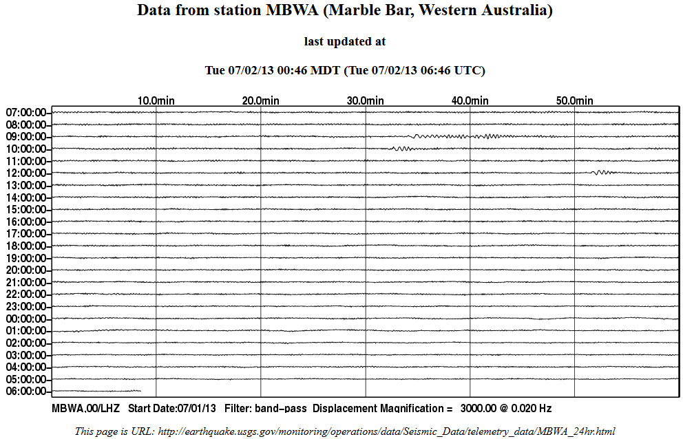
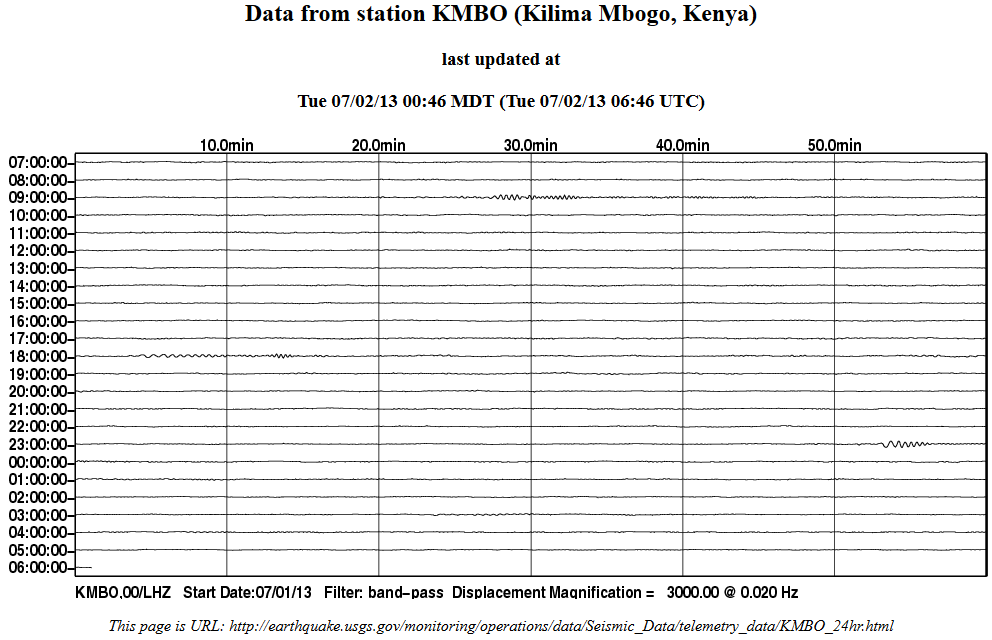
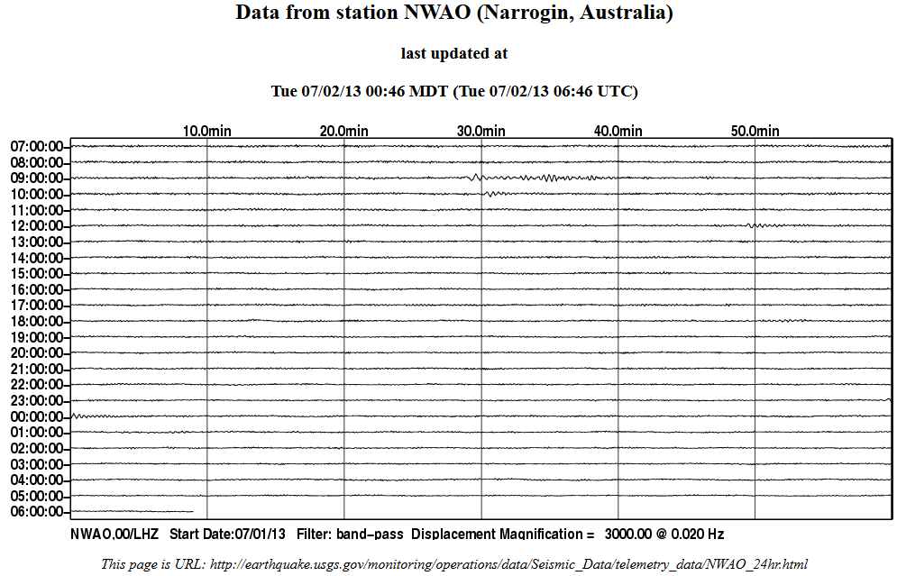
does anyone have a link or "gee" station that is closest to the cascadia subduction zone???
reply to post by PuterMan
Those long waves, the ones that don't cause vibration of the surface, what happens to the energy. Does it just move and get absorbed by the land or ocean? Do these cause swells to form on the ocean?
I've seen what a backhoe digging next to the lake does to a calm lake, it causes ripples way out. Trains running far from the water can cause tiny waves to appear on a lake. Maybe even a farmer plowing his fields causes waves.
Thanks for the info and links, I should check on this, I think there is an old seismograph in the garage up north yet, hopefully nobody threw it away. It would be fun to play with it. I think my stepfather got it for near nothing at an auction .
Originally posted by PuterMan
reply to post by rickymouse
Just to add, when you see a seismogram in America registering an event it is indeed a fact that the ground has moved. Amongst those links on that page you will find Oklahoma Geological Survey Seismogram, Spectrogram, and Magnetogram Index
interesting web site I haven't seen before.
I found this page there annual maps 1977 -2003 and the okecatalog here
It would take a bit of time, to "muzzify" the data in there (convert to interactive coloured icon maps muzzy style) , but it might be worth the effort, it kind of looks to me that "fracking" has been getting the blame for a lot of earthquakes lately, without any proper investigation as to the seismic history of the area. Or did I miss the memo?.
Next rainy day I'll run that stuff through and see what we get.
edit on 2-7-2013 by muzzy because: (no reason given)
www.ldeo.columbia.edu/~ekstrom/Research/SWD/current/RADB_SWD_grd.html

2013 7 1 23 35 20.0 -35.25 53.75 33.0 4.9 SOUTHWEST INDIAN RIDGE
2013 7 1 12 32 48.0 -29.75 75.75 33.0 4.9 MID-INDIAN RIDGE
2013 7 1 10 13 44.0 -29.75 75.25 33.0 4.9 MID-INDIAN RIDGE


www.emsc-csem.org...
Magnitude Mw 6.1
Region NORTHERN SUMATRA, INDONESIA
Date time 2013-07-02 07:37:03.0 UTC
Location 4.72 N ; 96.57 E
Depth 10 km
Distances 594 km W of Kuala Lumpur, Malaysia / pop: 1,453,975 / local time: 15:37:03.0 2013-07-02
166 km SE of Banda Aceh, Indonesia / pop: 250,757 / local time: 14:37:03.0 2013-07-02
55 km S of Bireun, Indonesia / pop: 25,793 / local time: 14:37:03.0 2013-07-02
I was away and missed this one on July 1st:
M3.2 - 6km NW of Fairport Harbor, Ohio
2013-07-01 07:48:45 UTC
This may not seem like anything to some but Ohio doesn't have many quakes and this is off shore. Historical says the largest here is 5.4 back in 1937
M3.2 - 6km NW of Fairport Harbor, Ohio
2013-07-01 07:48:45 UTC
This may not seem like anything to some but Ohio doesn't have many quakes and this is off shore. Historical says the largest here is 5.4 back in 1937
The strongest tremor of this series occurred at 11:45 p.m., March 8, 1937. At Anna, chimneys repaired after the March 2 earthquake were again thrown down, with scarcely a chimney undamaged (intensity VII to VIII). Organ pipes were twisted in one church and other church and school buildings were badly cracked. A few chimneys also fell at Sidney and there was damage to plaster. The affected area was much larger than that of the previous earthquake. The 388,000 square kilometer area covered all of Ohio and Indiana, parts of Illinois, Kentucky, Michigan, and a few places in Missouri, Pennsylvania, West Virginia, Wisconsin, and Ontario, Canada. Outstanding phenomena common to both the March 2 and March 8 earthquakes were the rotation of tombstones and subsurface changes revealed by the activities of wells. Marked changes in the behavior of wells were reported from Botkins, Huntsville, and New Knoxville.
M5.2 - 48km W of Kigorobya, Uganda 2013-07-02 13:33:18 UTC
Event Time
2013-07-02 13:33:18 UTC
2013-07-02 16:33:18 UTC+03:00 at epicenter
2013-07-02 08:33:18 UTC-05:00 system time
Location
1.583°N 30.877°E depth=20.5km (12.7mi)
Nearby Cities
48km (30mi) W of Kigorobya, Uganda
54km (34mi) WNW of Hoima, Uganda
69km (43mi) E of Bunia, Democratic Republic of the Congo
92km (57mi) S of Paidha, Uganda
235km (146mi) NW of Kampala, Uganda
USGS
reply to post by piequal3because14
Earthquake in Bener Meriah, Sumatra, Indonesia – 5 fatalities, dozens of people injured due to collapsed buildings and landslides.
Due to the fatalities, the status of this earthquake has increased to CATDAT Red.
Source
5.0 74km ESE of Lar, Iran 2013-07-02 06:18:32 UTC-05:0010.0 km
5.6 17km NNW of Hihifo, Tonga 2013-07-02 04:38:41 UTC-05:0042.8 km
USGS
edit on 2-7-2013 by lurksoften because: (no reason given)
reply to post by steve95988
Well, the subduction zone is close to 800 km long, so there are many stations that cover it.
This page from PNSN shows all of the seismometers in their coverage area. (on the right of the screen, "uncheck" the 'display clusters' box to see the individual stations)
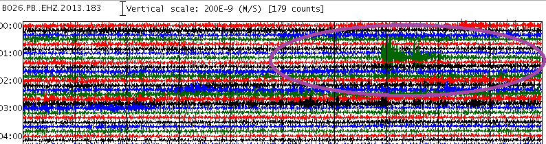
I like to use the PBO network stations, because they are down boreholes, so they have less cultural noise to sift through. From this network, B046 is near Ferndale, CA, B026 is along the north-central Oregon coast, and B926, B927, & B928 are under Vancouver Island, BC.
That will give you basic coverage. Until a new version of GEE is released, many of the stations will not load because of a software change.
....................................
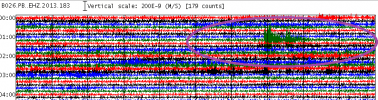
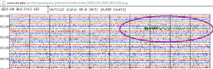
Speaking of the CSZ , I think a quake happened off the coast of Coos Bay, OR or maybe a bit farther north, at 01:16:40 "ish" UTC today.
I'm hoping it gets listed soon, because I'm puzzled by the different arrival times and waveforms.
This is what it looks like closer to the coast; from north to south:
 source(south of
Tillamook, OR)
source(south of
Tillamook, OR)
 source(Reedsport,
OR)
source(Reedsport,
OR)
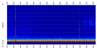
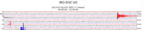
Now look at a few inland stations; the first is a UO.DBO.BHZ spectrogram, the second is UO.IRO.EHZ .
The 1st waves on the inland stations show up about 12 seconds later than the ones closest to the coast, but they look much stronger.
 source(south of Roseburg, OR)
more spectros from CSZ
source(in-between Eugene & Bend, OR)
Well, the subduction zone is close to 800 km long, so there are many stations that cover it.
This page from PNSN shows all of the seismometers in their coverage area. (on the right of the screen, "uncheck" the 'display clusters' box to see the individual stations)
I like to use the PBO network stations, because they are down boreholes, so they have less cultural noise to sift through. From this network, B046 is near Ferndale, CA, B026 is along the north-central Oregon coast, and B926, B927, & B928 are under Vancouver Island, BC.
That will give you basic coverage. Until a new version of GEE is released, many of the stations will not load because of a software change.
....................................
Speaking of the CSZ , I think a quake happened off the coast of Coos Bay, OR or maybe a bit farther north, at 01:16:40 "ish" UTC today.
I'm hoping it gets listed soon, because I'm puzzled by the different arrival times and waveforms.
This is what it looks like closer to the coast; from north to south:
 source(south of
Tillamook, OR)
source(south of
Tillamook, OR) 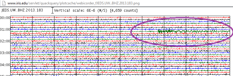 source(Reedsport,
OR)
source(Reedsport,
OR) Now look at a few inland stations; the first is a UO.DBO.BHZ spectrogram, the second is UO.IRO.EHZ .
The 1st waves on the inland stations show up about 12 seconds later than the ones closest to the coast, but they look much stronger.
 source(south of Roseburg, OR)
 more spectros from CSZ

source(in-between Eugene & Bend, OR)
edit on 7/2/2013 by Olivine because: add link to all
the spectros along the CSZ
reply to post by lurksoften
So sorry to hear that,I hope the damage and casualties will not increase and no other earthquake of that magnitude or higher will take place in
that area.
47min ago
www.emsc-csem.org...
will probably go down
2013-07-02 18:39:45 5.6 35.88°S 102.80°W 10 A Southeast of Easter Island
geofon.gfz-potsdam.de...
at this time Useless are still in the dark
2013-07-02 18:39:43.3 35.62 S 103.23 W 10 5.9 SOUTHEAST OF EASTER ISLAND
www.emsc-csem.org...
will probably go down
2013-07-02 18:39:45 5.6 35.88°S 102.80°W 10 A Southeast of Easter Island
geofon.gfz-potsdam.de...
at this time Useless are still in the dark
edit on 2-7-2013 by muzzy because: (no reason given)
Originally posted by aLLeKs
hmm I have some friends in Indonesia, but not in this region
same here....i have a friend on langkawi island malaysia. it faces indonesia and also the open ocean with a fault line running right past it. i have contacted him and told him to be alert. told him if you see the locals running...FOLLOW.
reply to post by bellagirl
Sorry to say that it is worse than is being reported thus far...
Link
From the site
Hope your loved one is safe.
Sorry to say that it is worse than is being reported thus far...
Earthquake in Bener Meriah, Sumatra, Indonesia – at least 25 people killed, +100 people injured due to collapsed buildings and landslides
Link
From the site
We are truly IRRITATED that the world press seems to focus only on wars and hardly reports about the misery of this earthquake. Roads are blocked, people are still under the rubble, etc. This is an important human tragedy and the only thing the world is doing is looking the other side !
Hope your loved one is safe.
why should world press care? it has no relation to the USA... just saying. (not my opinion)
Saddly this is often the reason to report. For example the big 8.0 ones we had earlier this year at Santa Cruz havent been reported at all, at least not in Germany.
Indonesia is not an "important" country in the eyes of the world press. 25 deaths are not enough to justify any reports... but if 1 European or American dies it will be reported... this is the sad truth about hour media :/
Anniversary in 1 1/4 hrs
thats that one that shook us here to the point we nearly got out of bed and took cover but it stopped before we did.
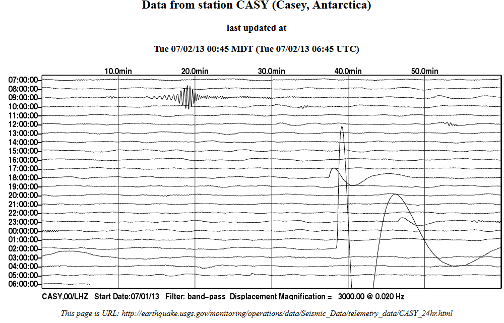
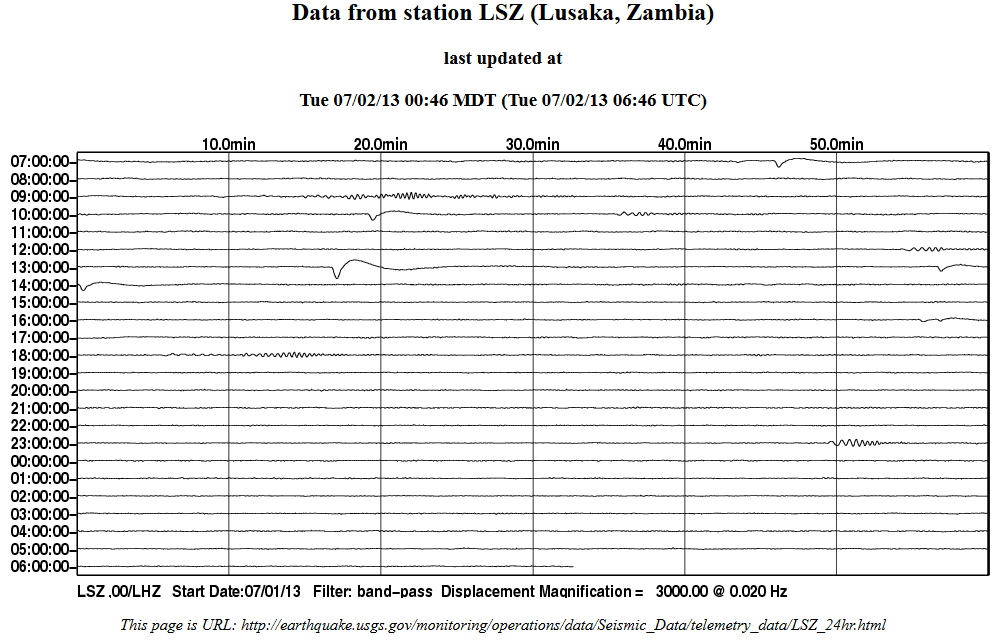
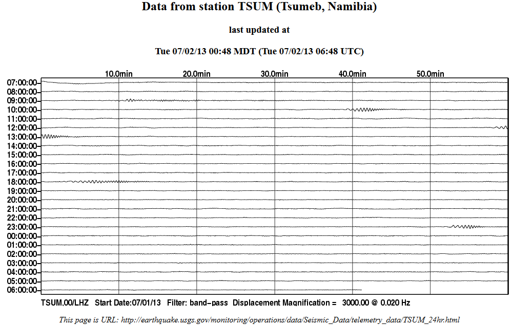
I was just looking at Wilber3 (which has some amazing data buried inside it) and found this graph which shows the global seismo traces based on distance.
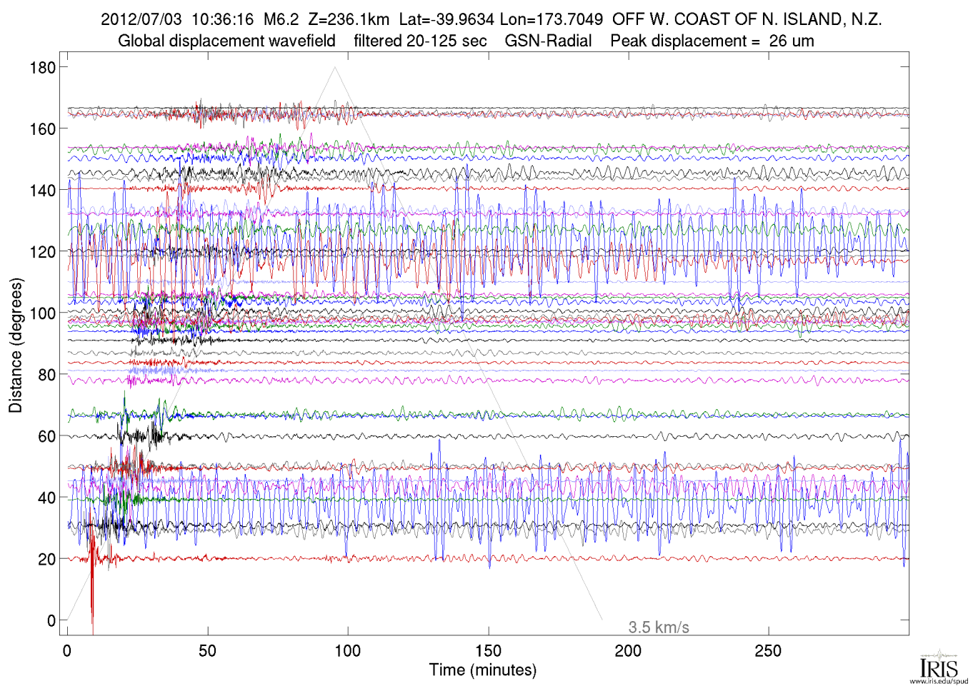 [color=8BB381](click image for larger version, opens in
new tab/window)
[color=8BB381](click image for larger version, opens in
new tab/window)
www.iris.edu...
This was the last big quake here, been a while !
40.023° S 173.756° E 2012-07-03 10:36:15 UTC 229.8 km 7.1ML (MW6.3) Cook Strait, New Zealand
thats that one that shook us here to the point we nearly got out of bed and took cover but it stopped before we did.
I was just looking at Wilber3 (which has some amazing data buried inside it) and found this graph which shows the global seismo traces based on distance.

www.iris.edu...
This was the last big quake here, been a while !
edit on 3-7-2013 by muzzy because: (no reason given)
This one had my heart pump a bit harder and faster, felt some adrenaline push in my head.
03.07.2013 09:05:56 65.062 -16.560 2.6 km 6.6 75.95 3.4 km NE of Dreki
But let's wait for the correction by an Icelandic Geologist at Icelandic Met Office
edit 1
Corrected it seems, removed actually.
03.07.2013 09:05:56 65.062 -16.560 2.6 km 6.6 75.95 3.4 km NE of Dreki
But let's wait for the correction by an Icelandic Geologist at Icelandic Met Office
edit 1
Corrected it seems, removed actually.
edit on 3-7-2013 by Nidwin because: correction made by Icelandic Met Office
M5.7 - 51km W of Kigorobya, Uganda 2013-07-03 19:21:46 UTC
Event Time
2013-07-03 19:21:46 UTC
2013-07-03 22:21:46 UTC+03:00 at epicenter
2013-07-03 14:21:46 UTC-05:00 system time
Location
1.563°N 30.850°E depth=9.8km (6.1mi)
USGS
5.3 70km N of Bristol Island, South Sandwich Islands 2013-07-03 15:16:39 UTC-05:00140.7 km
5.3 116km NE of L'Esperance Rock, New Zealand 2013-07-03 10:09:03 UTC-05:0071.7 km
5.0 41km ESE of Namie, Japan 2013-07-03 10:06:11 UTC-05:0016.2 km
5.2 6km SSE of Aiani, Greece 2013-07-03 08:28:23 UTC-05:003.7 km
5.2 52km E of Farkhar, Afghanistan 2013-07-03 02:04:17 UTC-05:00203.8 km
Uganda is a strange one 5.2 June 2nd then 5.7 June 3rd when they are lucky to get one 5 or above per year. I looked up the region and found this
Wiki
Oh, here is another...so now that is 3 in two days over 5
M5.4 - 57km W of Kigorobya, Uganda 2013-07-03 22:22:18 UTC
Heritage Oil (LSE: HOIL, TSX: HOC) is an independent Jersey-based oil and gas exploration and production company. Its activities are focused on Africa, the Middle East and Russia. It is listed on the London Stock Exchange and has a secondary listing on the Toronto Stock Exchange.
Wiki
The company is the operator and holds 50% interests in two licences in the Albert Basin of the Western Rift Valley of Uganda. Recent exploration activity has focused on the eastern shores of Lake Albert, which straddles the border of Uganda and the Democratic Republic of Congo, and Kurdistan. The company is also active in Russia, Malta, Mali and Tanzania.
Oh, here is another...so now that is 3 in two days over 5
M5.4 - 57km W of Kigorobya, Uganda 2013-07-03 22:22:18 UTC
reply to post by rickymouse
They do move the surface but over such a long 'period' that we would not really call it a vibration, but it is still expending it's energy (called attenuation as it reduces the signal) and eventually will fizzle out, so yes it gets absorbed by whatever it passes by.
Someone please correct me if I am wrong but ocean swell is caused by the wind just as the smaller waves are. The only swell caused by an earthquake is a tsunami. I don't believe that the seismic waves can cause a swell - even the surface seismic waves.
Those long waves, the ones that don't cause vibration of the surface, what happens to the energy. Does it just move and get absorbed by the land or ocean? Do these cause swells to form on the ocean?
They do move the surface but over such a long 'period' that we would not really call it a vibration, but it is still expending it's energy (called attenuation as it reduces the signal) and eventually will fizzle out, so yes it gets absorbed by whatever it passes by.
Someone please correct me if I am wrong but ocean swell is caused by the wind just as the smaller waves are. The only swell caused by an earthquake is a tsunami. I don't believe that the seismic waves can cause a swell - even the surface seismic waves.
edit on 3/7/2013 by PuterMan because: (no
reason given)
reply to post by PuterMan
A train running over a track does make little waves in a perfectly calm lake, they start a while before the train even gets there. It takes about five minutes after the train goes by for the ripples to subside. I fished a lot by the traintracks when I was young. The train usually came by once a day that I knew of, usually hauling coal.
I can't imagine that earthquakes would not make waves, it would be hard to distinguish though. There are quakes and volcanic activity constantly going on around the world. When the ice cracks off a glacier, you can feel the snap through the ground, I experienced that in Alaska. I think all these events cause waves or possibly swells to form but they are just so common that noone thinks of it.
new topics
-
Where should Trump hold his next rally
2024 Elections: 1 hours ago -
Shocking Number of Voters are Open to Committing Election Fraud
US Political Madness: 2 hours ago -
Gov Kristi Noem Shot and Killed "Less Than Worthless Dog" and a 'Smelly Goat
2024 Elections: 3 hours ago -
Falkville Robot-Man
Aliens and UFOs: 3 hours ago -
James O’Keefe: I have evidence that exposes the CIA, and it’s on camera.
Whistle Blowers and Leaked Documents: 4 hours ago -
Australian PM says the quiet part out loud - "free speech is a threat to democratic dicourse"...?!
New World Order: 4 hours ago -
Ireland VS Globalists
Social Issues and Civil Unrest: 5 hours ago -
Biden "Happy To Debate Trump"
2024 Elections: 5 hours ago -
RAAF airbase in Roswell, New Mexico is on fire
Aliens and UFOs: 5 hours ago -
What is the white pill?
Philosophy and Metaphysics: 7 hours ago
top topics
-
A Warning to America: 25 Ways the US is Being Destroyed
New World Order: 15 hours ago, 21 flags -
Blast from the past: ATS Review Podcast, 2006: With All Three Amigos
Member PODcasts: 8 hours ago, 11 flags -
Biden "Happy To Debate Trump"
2024 Elections: 5 hours ago, 10 flags -
James O’Keefe: I have evidence that exposes the CIA, and it’s on camera.
Whistle Blowers and Leaked Documents: 4 hours ago, 9 flags -
Mike Pinder The Moody Blues R.I.P.
Music: 8 hours ago, 8 flags -
Australian PM says the quiet part out loud - "free speech is a threat to democratic dicourse"...?!
New World Order: 4 hours ago, 8 flags -
What is the white pill?
Philosophy and Metaphysics: 7 hours ago, 5 flags -
RAAF airbase in Roswell, New Mexico is on fire
Aliens and UFOs: 5 hours ago, 5 flags -
Ireland VS Globalists
Social Issues and Civil Unrest: 5 hours ago, 4 flags -
Putin, Russia and the Great Architects of the Universe
ATS Skunk Works: 11 hours ago, 4 flags
active topics
-
Putin, Russia and the Great Architects of the Universe
ATS Skunk Works • 27 • : KnowItAllKnowNothin -
Falkville Robot-Man
Aliens and UFOs • 5 • : Ophiuchus1 -
RAAF airbase in Roswell, New Mexico is on fire
Aliens and UFOs • 7 • : pianopraze -
Biden "Happy To Debate Trump"
2024 Elections • 42 • : JadedGhost -
Gold and silver prices....woo hoo
History • 86 • : lilzazz -
Mood Music Part VI
Music • 3110 • : TheDiscoKing -
University of Texas Instantly Shuts Down Anti Israel Protests
Education and Media • 308 • : cherokeetroy -
Meadows, Giuliani Among 11 Indicted in Arizona in Latest 2020 Election Subversion Case
Mainstream News • 29 • : Threadbarer -
Where should Trump hold his next rally
2024 Elections • 7 • : spacedoubt -
Shocking Number of Voters are Open to Committing Election Fraud
US Political Madness • 4 • : WeMustCare