It looks like you're using an Ad Blocker.
Please white-list or disable AboveTopSecret.com in your ad-blocking tool.
Thank you.
Some features of ATS will be disabled while you continue to use an ad-blocker.

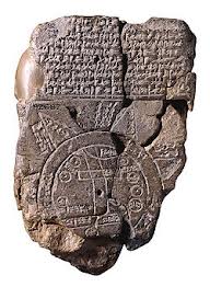
The Babylonian map of the world, circa 2700 BP
page: 1share:
It was excavated at Sippar, southern Iraq, 100 km north of Babylon on the east bank of the Euphrates River, in 1899. It is made on a baked clay
tablet and 12.2 cms tall but the tablet is damaged. It contains a number of cuneiform text which are translated below. It is dated to the 7-5th
century BCE. This map is one of the first to give a view of the world as thought of by the inhabitants of Babylon. It is thought that the island
locations, may also represent a mythological interpretation of the world, instead of real islands.
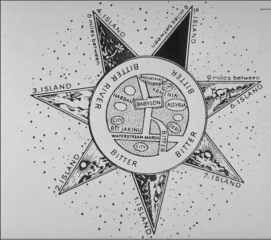
A drawing of the map with the points named
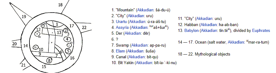
The translation is from the wiki article on the map
Seven triangular sections on the external circle (water perimeter), represent named islands, but the damaged clay tablet has lost the three islands on the tablet's lower edge.The three islands were: "place of the rising sun" island, "the sun is hidden and nothing can be seen" island, "beyond the flight of birds"
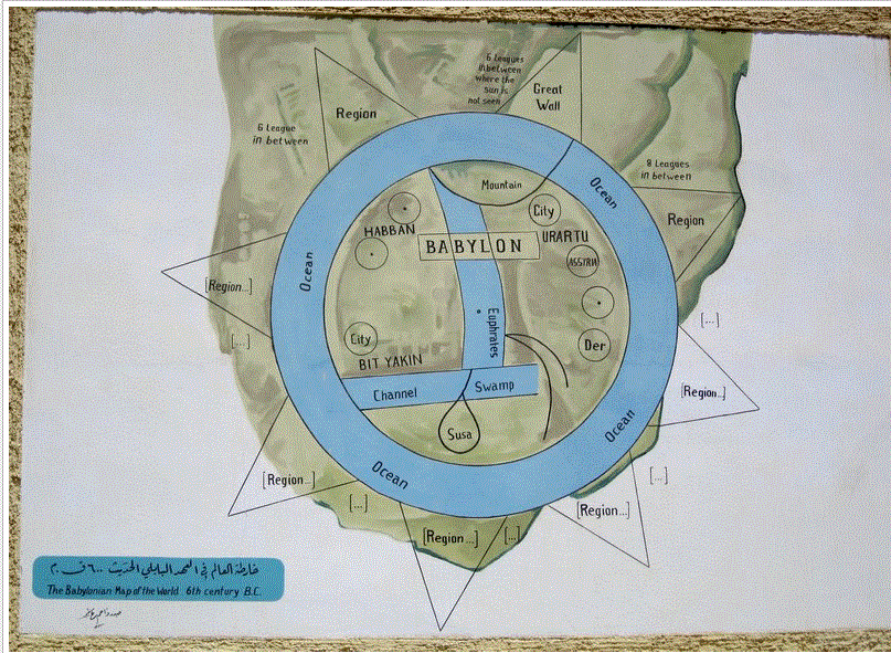
Another more colourful version of the map
Link to a book on map which covers the discovery of the map and its importance
A drawing of the map with the points named
The translation is from the wiki article on the map
Seven triangular sections on the external circle (water perimeter), represent named islands, but the damaged clay tablet has lost the three islands on the tablet's lower edge.The three islands were: "place of the rising sun" island, "the sun is hidden and nothing can be seen" island, "beyond the flight of birds"
Another more colourful version of the map
Link to a book on map which covers the discovery of the map and its importance
edit on 24/11/12 by Hanslune because: (no reason given)
Very interesting thank you for posting. I notice if I squint really hard and close my eyes I see there are no alien runways or star charts to the
Plaedies so this is obviously a hoax
Seriously though I find it fascinating and realize I have never really looked into how the Babylonians viewed the world around them geographically speaking.
Seriously though I find it fascinating and realize I have never really looked into how the Babylonians viewed the world around them geographically speaking.
The map as reconstructed by Eckhard Unger shows Babylon on the Euphrates, surrounded by a circular landmass showing Assyria, Urartu[3] and several cities, in turn surrounded by a "bitter river" (Oceanus), with seven islands arranged around it so as to form a seven-pointed star. The accompanying text mentions seven outer regions beyond the encircling ocean. The descriptions of five of them have survived[4]:
the third island is where "the winged bird ends not his flight," i.e., cannot reach.
on the fourth island "the light is brighter than that of sunset or stars": it lay in the northwest, and after sunset in summer was practically in semi-obscurity.
The fifth island, due north, lay in complete darkness, a land "where one sees nothing," and "the sun is not visible."
the sixth island, "where a horned bull dwells and attacks the newcomer"
the seventh island lay in the east and is "where the morning dawns."
en.wikipedia.org...
If you click on that link, there is a collection of early world maps, amazing stuff.
Does anybody know the technical term for these styles of early maps in which they were circular, main point of interest in the middle and the actual locations of surrounding locations don't necessarily reflect the actual locations, but rather they were situated as to creating reference points. I don't think I described it as well as I could of, but if you know what I'm talking about... this should be enough.
reply to post by Hanslune
This is very cool, and the map makes sense from a certain perspective where unexplored/unknown far reaches are even described as place of rising sun, sun is hidden, and other such.
It's definitely a wonderful insight into the understanding of how an 'advanced' ancient peoples saw the world they lived in.
Later, Western culture maps would add in the Terra Incognito we're all familiar with, but, the Babylonians broke the unknown up into these fascinating 'islands'.
In the picture of the tablet there appears to be a hole in the middle. Is this intentional or is it just a result of chipping? Looking at the
triangular shapes and this hole made me think of a sun-dial. Perhaps this was a way calculating time or plotting position relative to the sun? I
don't know much about cartography so this could be way off but couldn't help but notice the similarities.
Don't think for a second that literally everyone in Babylon in 700BCE believed that this was an accurate depiction of the world. Far from it.
It's way too small to be a real depiction of everything they knew about the world. It depicts no more than ~100 miles diameter. You could travel across that distance depicted here on foot in under a week, and a little longer than that would be a comfortable pace.
It's not at all comparable to Plato's concept of the world, which basically depicted all of Turkey and North Africa and the Mediterranean, an area about ~2000 miles wide and ~1000 tall and really probably was just about everything they knew enough to put on a basic map of the average educated aristocrat's worldview.
This is only from a few hundred years earlier. Anyone from the region who was at all intelligent and educated would have known it was total BS. Longer distance trade was long since well established. Where is the centuries old empire of Egypt, for example? It doesn't even depict all of Babylon's own territory from the time of Hammurabi which was around ~1790 to ~1750 BCE.
The Assyrians were in charge there around then, so it would have to be an Assyrian lie. Basic propaganda, thought control, mind control, call it what you want to. It's a lie they'd tell average folks to keep them in their place. So at best, it was only the official lie told to the people who were born to toil, many of whom would never in their lifetime leave their local area. Plenty of those people would even know better.
It basically for telling people that they all live in a big natural corral so don't even think of running away because there's no where to go, and now will you all please go get back to work.
you see that part that says...great wall
would that be the wailing wall?
would that be the wailing wall?
Originally posted by NihilistSanta
In the picture of the tablet there appears to be a hole in the middle. Is this intentional or is it just a result of chipping? Looking at the triangular shapes and this hole made me think of a sun-dial. Perhaps this was a way calculating time or plotting position relative to the sun? I don't know much about cartography so this could be way off but couldn't help but notice the similarities.
It was assembled from fragments it would appear some were lost
reply to post by 11andrew34
I take it as a local map set in a larger context, it may have had some meaning to the maker that wasn't intended as a map. As only scribes and priests could read the use of this as 'propaganda' would have been limited.
I take it as a local map set in a larger context, it may have had some meaning to the maker that wasn't intended as a map. As only scribes and priests could read the use of this as 'propaganda' would have been limited.
Originally posted by thePharaoh
you see that part that says...great wall
would that be the wailing wall?
I take that to stand for the defensive wall that once existed ran between the two rivers to block any access to the central Mesopotomia between-the-rivers plain
It is thought the very first Wall (in the west) not built around a city was erected by the Sumerian King Shu-Sin, son of Shulgi, around 2038 BCE. Shu-Sin’s wall was 275 kilometers long and was built between the Tigris and Euphrates rivers to keep the invading Amorites out of Sumerian lands
edit on 24/11/12 by Hanslune because: (no reason given)
Originally posted by NihilistSanta
In the picture of the tablet there appears to be a hole in the middle. Is this intentional or is it just a result of chipping?
I'm certain that it's the chips you're seeing, which have left holes.
Babylonians, had they meant for a hole to be there, were perfectly capable of cutting a visually perfect circle in stone and they would have.
Hans,
Nice post. This is the oldest map I've ever seen, not that I've looked that much.
I doubt it was meant as a map in the sense that we use the term.
Harte
Originally posted by Hanslune
the Sumerian King Shu-Sin, son of Shulgi, around 2038 BCE. Shu-Sin’s wall was 275 kilometers long and
shu?? wasnt he an egyptian god
Originally posted by thePharaoh
Originally posted by Hanslune
the Sumerian King Shu-Sin, son of Shulgi, around 2038 BCE. Shu-Sin’s wall was 275 kilometers long and
shu?? wasnt he an egyptian god
Chinese they named moo shu pork after him
Originally posted by Harte
Originally posted by NihilistSanta
In the picture of the tablet there appears to be a hole in the middle. Is this intentional or is it just a result of chipping?
I'm certain that it's the chips you're seeing, which have left holes.
Babylonians, had they meant for a hole to be there, were perfectly capable of cutting a visually perfect circle in stone and they would have.
Hans,
Nice post. This is the oldest map I've ever seen, not that I've looked that much.
I doubt it was meant as a map in the sense that we use the term.
Harte
Yes its a bit of a puzzle - yeah cannot find the orginal site report, I would suspect it wasn't found in a king's library
Nice find...S & F.
Is there any way to overlay this with todays map to verify any of the marked areas?
Thanks for sharing.
Is there any way to overlay this with todays map to verify any of the marked areas?
Thanks for sharing.
Originally posted by Julie Washington
Nice find...S & F.
Is there any way to overlay this with todays map to verify any of the marked areas?
Thanks for sharing.
Howdy Julie
It roughly depicts the southern Mesopotamia area
reply to post by Hanslune
this must be a local map as you stated
the Euphrates river is on the map
but the Tigris river isnt
ETA different pics
on your pic number 6 is just ?
on this one it says BITTER, any idea what a bitter is?
nice find
this must be a local map as you stated
the Euphrates river is on the map
but the Tigris river isnt
ETA different pics
on your pic number 6 is just ?
on this one it says BITTER, any idea what a bitter is?
nice find
edit on 25-11-2012 by GezinhoKiko because: (no reason given)
edit on 25-11-2012 by GezinhoKiko because: (no reason
given)
reply to post by Harte
hi harte
heres an interesting link you may enjoy
just found it thru the Wiki link Hanslune provided in the OP
its a nice reference link for further research in ancient maps if anyones interested
Ancient Cartography
hi harte
heres an interesting link you may enjoy
just found it thru the Wiki link Hanslune provided in the OP
its a nice reference link for further research in ancient maps if anyones interested
Ancient Cartography
The unofficial oldest map in the world was discovered in Ukraine in 1966, dating from about 11 - 12,000 B.C. Inscribed on a mammoth tusk it was found in Mezhirich, Ukraine. It has been interpreted to show a river with dwellings along a river. However, the best claim to the title of "the earliest map in the world" appears on a beautifully engraved silver vase from Maikop in Ukraine, according to James and Thorpe. It was found in a Ukrainian tomb dated at 5,000 years old. It shows two rivers, a mountain range, a lake or sea and wild animals (3).
reply to post by GezinhoKiko
Bitter is the river that is by Babylon. Link This link will better explain some of the markings on the map.
Bitter is the river that is by Babylon. Link This link will better explain some of the markings on the map.
thanks for the link I B Dazzlin
on a side note
why is this called "Babylonian map of the world?"
by 500-600BC, Babylonians had traveled far and wide eg, Egypt, Turkey, India
is the name just a modern name?
on a side note
why is this called "Babylonian map of the world?"
by 500-600BC, Babylonians had traveled far and wide eg, Egypt, Turkey, India
is the name just a modern name?
new topics
-
BIDEN Admin Begins Planning For January 2025 Transition to a New President - Today is 4.26.2024.
2024 Elections: 6 hours ago -
Big Storms
Fragile Earth: 7 hours ago -
Where should Trump hold his next rally
2024 Elections: 10 hours ago -
Shocking Number of Voters are Open to Committing Election Fraud
US Political Madness: 11 hours ago
top topics
-
James O’Keefe: I have evidence that exposes the CIA, and it’s on camera.
Whistle Blowers and Leaked Documents: 12 hours ago, 17 flags -
Australian PM says the quiet part out loud - "free speech is a threat to democratic dicourse"...?!
New World Order: 13 hours ago, 15 flags -
Blast from the past: ATS Review Podcast, 2006: With All Three Amigos
Member PODcasts: 17 hours ago, 14 flags -
Biden "Happy To Debate Trump"
2024 Elections: 14 hours ago, 14 flags -
Ireland VS Globalists
Social Issues and Civil Unrest: 14 hours ago, 11 flags -
Mike Pinder The Moody Blues R.I.P.
Music: 17 hours ago, 9 flags -
BIDEN Admin Begins Planning For January 2025 Transition to a New President - Today is 4.26.2024.
2024 Elections: 6 hours ago, 9 flags -
Big Storms
Fragile Earth: 7 hours ago, 8 flags -
What is the white pill?
Philosophy and Metaphysics: 16 hours ago, 6 flags -
Shocking Number of Voters are Open to Committing Election Fraud
US Political Madness: 11 hours ago, 6 flags
active topics
-
Man possibly killed by werewolf in Texas
Cryptozoology • 28 • : RustyShack78 -
Most Compelling Loch Ness Monster Pictures Defy Explanation
Cryptozoology • 60 • : RustyShack78 -
Hate makes for strange bedfellows
US Political Madness • 54 • : Terpene -
A Warning to America: 25 Ways the US is Being Destroyed
New World Order • 30 • : glen200376 -
Eclipse picture taken by my son from the NH-ME border - Cool!
General Chit Chat • 26 • : EyeoftheHurricane -
University of Texas Instantly Shuts Down Anti Israel Protests
Education and Media • 319 • : CriticalStinker -
-@TH3WH17ERABB17- -Q- ---TIME TO SHOW THE WORLD--- -Part- --44--
Dissecting Disinformation • 705 • : cherokeetroy -
Falkville Robot-Man
Aliens and UFOs • 10 • : billxam1 -
Gov Kristi Noem Shot and Killed "Less Than Worthless Dog" and a 'Smelly Goat
2024 Elections • 64 • : cherokeetroy -
What is the white pill?
Philosophy and Metaphysics • 23 • : TheDiscoKing