It looks like you're using an Ad Blocker.
Please white-list or disable AboveTopSecret.com in your ad-blocking tool.
Thank you.
Some features of ATS will be disabled while you continue to use an ad-blocker.

iOS 6 Maps Apocalyptic Pictures
page: 13
share:
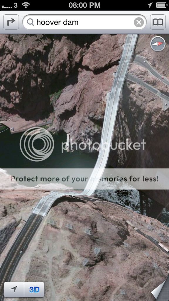
The new maps app for iOS 6 has some very interesting scenes, here is the Hoover Dam -

Are these examples of a technical glitch or are they trying to tell us something?
www.businessinsider.com...
www.theblaze.com...
Thoughts?
Are these examples of a technical glitch or are they trying to tell us something?
Less than a day after Apple released iOS 6 and unveiled its in-house maps, users have gone to Twitter and Tumblr to post their most ridiculous findings. When using the 3D feature, some searches end up showing you an apocalyptic rendition of some of the world's most cherished monuments.
www.businessinsider.com...
The fine folks over at Business Insider have put together a slideshow with the help of theamazingios6maps tumblr page detailing just some of the issues. Among the most hilarious? Road and bridges that are so distorted they look like roller coasters, an airport runway that looks like a quilt, and a very flat Eiffel Tower. Take a look for yourself:
www.theblaze.com...
Thoughts?
I heard on the news today that a few towns in England were covered by fog when they took the photos so all you see is fog. They also said a few
English towns are completely missing.
Yep, the BBC had something on the site a couple of days ago about how useless the app was for a lot of people in the UK. But there was no mention of
things like this in that piece, just that it was very inconvenient and pretty useless for a lot of people.
I think it's obvious that these are errors, or someone's idea of a joke perhaps. But I very much doubt it's some kind of "portent of doom"
I think it's obvious that these are errors, or someone's idea of a joke perhaps. But I very much doubt it's some kind of "portent of doom"
I'm not too knowledgeable on the new map thing, but I'm pretty sure google earth 3-D had/has similar issues.
www.maproomblog.com...
I think it's an issue with putting 2-D images on a 3-D model.
www.maproomblog.com...
I think it's an issue with putting 2-D images on a 3-D model.
Originally posted by Signals
Are these examples of a technical glitch or are they trying to tell us something?
They are trying to tell us that Asphalt is a thing of the past, and roads of the future will be made out of 100% rubber.
It's their new "3D" mapping technology. It's terrible in every way compared to the google maps they replaced. Go check out the Eiffel tower lol
edit on 22-9-2012 by Shadowcast because: (no reason given)
It would trash my suspension in my car.... BUT I bet that would be fun to drive over! Look no breaks really!! Obviously a glitch in the software.. And
a funny one at that! 3D mapping is not THAT easy now is it?
('')
('')
reply to post by Signals
This is a cluster Fack if I've ever seen one.
glad I wasn't dumb enough to buy an iphone.....ever.
This is a cluster Fack if I've ever seen one.
glad I wasn't dumb enough to buy an iphone.....ever.
Originally posted by glen200376
I heard on the news today that a few towns in England were covered by fog when they took the photos so all you see is fog. They also said a few English towns are completely missing.
This is generally regarded as a good thing
So what part of the software is unable to handle bridges? These are not photo images like google earth? But software translations from an image data
base?
In case they need to brush out any detail they don't want you to see?
In case they need to brush out any detail they don't want you to see?
reply to post by intrptr
The part that applies images to a digital elevation model (DEM) which does not have the resolution to show the bridge.
As far as the software is concerned, the bridge follows the terrain.
So what part of the software is unable to handle bridges?
The part that applies images to a digital elevation model (DEM) which does not have the resolution to show the bridge.
As far as the software is concerned, the bridge follows the terrain.
edit on 9/22/2012 by Phage because: (no reason given)
reply to post by Phage
Thanks Phage. That makes sense.
So with that in mind, I see the Eiffel Tower as flattened, why not other buildings or structures?
Also found it curious that these items are denoted as "terror targets" by officialdom. My instant response was, oh yeah, they don't want anyone analyzing these structures nowadays.
It seems they have fixed their bug now, so it is what you say. A 2 dimensional flatland to 3D imaging "blindspot".
As far as the software is concerned, the bridge follows the terrain.
Thanks Phage. That makes sense.
So with that in mind, I see the Eiffel Tower as flattened, why not other buildings or structures?
Also found it curious that these items are denoted as "terror targets" by officialdom. My instant response was, oh yeah, they don't want anyone analyzing these structures nowadays.
It seems they have fixed their bug now, so it is what you say. A 2 dimensional flatland to 3D imaging "blindspot".
Ahhhaa Apple FAIL.
We've got a few odd things according to Apple Maps too, like having Kalgoorlie as a residential address listed in Perth. I swear they've taken mining to a microscopic level, cannot see a thing around here to do with mining.
lol
Apple smugly comes up with an Ipod. Seeing dollar signs they make an Iphone and then an Ipad. Everyone is in awe... till google comes along.
"LoOk at our OS. It runs on phones and tablets. It has google maps, and navigation. We sort of implement flash. And we HAVE USB PORTS guys!!!! Also, we're free!"
Apple sternly stares towards the big ominous logo.. GoOgle.
Shaking it's fist and activating "Shake and change it up" they come at google bro.. Ego bruised and kidneys bleeding, Apple walks back into their barn and close the doors...
"IPHONE 4 GUYS!!!!!"
"Wait... IPHONE NEW!!"
"Wait... IPHONE 5 !!!!! It has 4g for reals in Australia you guys, It does!!!!!"
and so the lonely story of how the apple fell from the cart is a short one... because kids these days simply do no have the attention span to accurately follow a .. the end.
new topics
-
BIDEN Admin Begins Planning For January 2025 Transition to a New President - Today is 4.26.2024.
2024 Elections: 1 hours ago -
Big Storms
Fragile Earth: 2 hours ago -
Where should Trump hold his next rally
2024 Elections: 5 hours ago -
Shocking Number of Voters are Open to Committing Election Fraud
US Political Madness: 6 hours ago -
Gov Kristi Noem Shot and Killed "Less Than Worthless Dog" and a 'Smelly Goat
2024 Elections: 7 hours ago -
Falkville Robot-Man
Aliens and UFOs: 7 hours ago -
James O’Keefe: I have evidence that exposes the CIA, and it’s on camera.
Whistle Blowers and Leaked Documents: 7 hours ago -
Australian PM says the quiet part out loud - "free speech is a threat to democratic dicourse"...?!
New World Order: 8 hours ago -
Ireland VS Globalists
Social Issues and Civil Unrest: 9 hours ago -
Biden "Happy To Debate Trump"
2024 Elections: 9 hours ago
top topics
-
James O’Keefe: I have evidence that exposes the CIA, and it’s on camera.
Whistle Blowers and Leaked Documents: 7 hours ago, 14 flags -
Australian PM says the quiet part out loud - "free speech is a threat to democratic dicourse"...?!
New World Order: 8 hours ago, 13 flags -
Blast from the past: ATS Review Podcast, 2006: With All Three Amigos
Member PODcasts: 12 hours ago, 13 flags -
Biden "Happy To Debate Trump"
2024 Elections: 9 hours ago, 12 flags -
Mike Pinder The Moody Blues R.I.P.
Music: 12 hours ago, 8 flags -
What is the white pill?
Philosophy and Metaphysics: 11 hours ago, 6 flags -
Shocking Number of Voters are Open to Committing Election Fraud
US Political Madness: 6 hours ago, 6 flags -
RAAF airbase in Roswell, New Mexico is on fire
Aliens and UFOs: 9 hours ago, 5 flags -
Ireland VS Globalists
Social Issues and Civil Unrest: 9 hours ago, 5 flags -
Where should Trump hold his next rally
2024 Elections: 5 hours ago, 5 flags
active topics
-
ALERT - U.S. President JOE BIDEN Examined and Found NOT OF SOUND MIND.
2024 Elections • 65 • : SchrodingersRat -
James O’Keefe: I have evidence that exposes the CIA, and it’s on camera.
Whistle Blowers and Leaked Documents • 13 • : theatreboy -
Where should Trump hold his next rally
2024 Elections • 21 • : Dandandat3 -
Gov Kristi Noem Shot and Killed "Less Than Worthless Dog" and a 'Smelly Goat
2024 Elections • 45 • : cherokeetroy -
RAAF airbase in Roswell, New Mexico is on fire
Aliens and UFOs • 9 • : Degradation33 -
President BIDEN's FBI Raided Donald Trump's Florida Home for OBAMA-NORTH KOREA Documents.
Political Conspiracies • 38 • : SchrodingersRat -
Big Storms
Fragile Earth • 11 • : GENERAL EYES -
BIDEN Admin Begins Planning For January 2025 Transition to a New President - Today is 4.26.2024.
2024 Elections • 7 • : WannabeeAuCourant -
Joe Biden and Donald Trump are both traitors
2024 Elections • 65 • : MrMez -
Mood Music Part VI
Music • 3112 • : underpass61
3