It looks like you're using an Ad Blocker.
Please white-list or disable AboveTopSecret.com in your ad-blocking tool.
Thank you.
Some features of ATS will be disabled while you continue to use an ad-blocker.

Commercial Flights over Groom Lake Area??
page: 10
share:
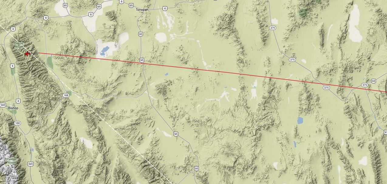
Take a look here at two United flights being really close to Groom Lake area.
I thought this was a very restricted area which would be R-4808N.
This was taken from Planefinder.net
Is this normal especially if Nellis are NOT conducting Red Flags??
I thought this was a very restricted area which would be R-4808N.
This was taken from Planefinder.net
Is this normal especially if Nellis are NOT conducting Red Flags??


edit on 13-7Jul-122012 by darpa999 because: (no reason given)
Even with no flags running, commercial aircraft would not be flying that close to Groom Lake. What is happening is there are thunderstorms around
Vegas. The last time I check they were west of the city. Ely is really getting zapped. By some fluke, the NTTR is relatively lightning free. Thus ATC
instructed the commercial flights to go over the range. It is Nellis Control in charge, so it is not like the DoD doesn't know what is going on.
I posted one of these reroutings a few years ago.
I posted one of these reroutings a few years ago.
www.abovetopsecret.com...
This is my old post. Don't get me wrong concerning my interest level. Any time some commercial plane flies over the range, I would like to hear about it.
This is the live lightning viewer for the Nellis range;
www.sord.nv.doe.gov...
This is my old post. Don't get me wrong concerning my interest level. Any time some commercial plane flies over the range, I would like to hear about it.
This is the live lightning viewer for the Nellis range;
www.sord.nv.doe.gov...
Here is the NOTAM for the current Red Flag. "L" indicates local time. "Z" for zulu. Note Nellis gets the times wrong often. ;-) Due to the
location of the international dateline, even the days are often posted incorrectly.
Data Current as of: Sat, 14 Jul 2012 01:58:00 UTC
LSV NELLIS AFB M0254/12 -
LARGE FORCE EXERCISE IN PROGRESS. NO TRANSIENT ACFT ARRIVAL OR DEPARTURES DURING LAUNCH AND RECOVERY TIMES.
MASS LAUNCH AND RECOVERY TIMES ARE:
16-17 JULY 1500-1600L (2200-2300Z),
1700-1830L(0000-0130Z),
AND
2130-2230L(0430-0530Z).
13 JUL 22:40 2012 UNTIL 17 JUL 05:30 2012.
CREATED: 13 JUL 22:45 2012 TNX
TONOPAH TEST RANGE
M0108/12 -
MOVEMENT AREA VFR OPERATORS USE CAUTION FOR INCREASED VOLUME OF HIGH PERFORMANCE MILITARY FLIGHT OPERATIONS THROUGHOUT R4809A. 13 JUL 14:04 2012 UNTIL 20 JUL 23:59 2012. CREATED: 13 JUL 14:11 2012
For some reason your images were deleted. If they were on planefinder, most likely they are on flightaware if you know the flight ID or tail number.
Do you have that data available?
Interesting...I've never heard of a commercial plane flying directly over 4808. That would be pretty cool for the passengers. lol
new topics
-
BIDEN Admin Begins Planning For January 2025 Transition to a New President - Today is 4.26.2024.
2024 Elections: 2 hours ago -
Big Storms
Fragile Earth: 4 hours ago -
Where should Trump hold his next rally
2024 Elections: 7 hours ago -
Shocking Number of Voters are Open to Committing Election Fraud
US Political Madness: 7 hours ago -
Gov Kristi Noem Shot and Killed "Less Than Worthless Dog" and a 'Smelly Goat
2024 Elections: 8 hours ago -
Falkville Robot-Man
Aliens and UFOs: 8 hours ago -
James O’Keefe: I have evidence that exposes the CIA, and it’s on camera.
Whistle Blowers and Leaked Documents: 9 hours ago -
Australian PM says the quiet part out loud - "free speech is a threat to democratic dicourse"...?!
New World Order: 10 hours ago -
Ireland VS Globalists
Social Issues and Civil Unrest: 10 hours ago -
Biden "Happy To Debate Trump"
2024 Elections: 11 hours ago
top topics
-
James O’Keefe: I have evidence that exposes the CIA, and it’s on camera.
Whistle Blowers and Leaked Documents: 9 hours ago, 17 flags -
Australian PM says the quiet part out loud - "free speech is a threat to democratic dicourse"...?!
New World Order: 10 hours ago, 15 flags -
Blast from the past: ATS Review Podcast, 2006: With All Three Amigos
Member PODcasts: 13 hours ago, 13 flags -
Biden "Happy To Debate Trump"
2024 Elections: 11 hours ago, 13 flags -
Ireland VS Globalists
Social Issues and Civil Unrest: 10 hours ago, 9 flags -
Mike Pinder The Moody Blues R.I.P.
Music: 13 hours ago, 8 flags -
BIDEN Admin Begins Planning For January 2025 Transition to a New President - Today is 4.26.2024.
2024 Elections: 2 hours ago, 7 flags -
What is the white pill?
Philosophy and Metaphysics: 13 hours ago, 6 flags -
Shocking Number of Voters are Open to Committing Election Fraud
US Political Madness: 7 hours ago, 6 flags -
Big Storms
Fragile Earth: 4 hours ago, 6 flags
active topics
-
BIDEN Admin Begins Planning For January 2025 Transition to a New President - Today is 4.26.2024.
2024 Elections • 18 • : rickymouse -
RAAF airbase in Roswell, New Mexico is on fire
Aliens and UFOs • 12 • : pianopraze -
A Warning to America: 25 Ways the US is Being Destroyed
New World Order • 29 • : 19Bones79 -
Big Storms
Fragile Earth • 15 • : Caver78 -
What is the white pill?
Philosophy and Metaphysics • 22 • : AlexandrosOMegas -
University of Texas Instantly Shuts Down Anti Israel Protests
Education and Media • 315 • : CriticalStinker -
Gov Kristi Noem Shot and Killed "Less Than Worthless Dog" and a 'Smelly Goat
2024 Elections • 58 • : cherokeetroy -
Biden "Happy To Debate Trump"
2024 Elections • 51 • : rickymouse -
Hate makes for strange bedfellows
US Political Madness • 53 • : 19Bones79 -
SETI chief says US has no evidence for alien technology. 'And we never have'
Aliens and UFOs • 79 • : SchrodingersRat
0