It looks like you're using an Ad Blocker.
Please white-list or disable AboveTopSecret.com in your ad-blocking tool.
Thank you.
Some features of ATS will be disabled while you continue to use an ad-blocker.

Seeing is believing. Possible geo engineering nsw 13-3-2012
page: 12
share:
long story short went outside to grab the washing, saw really odd clouds and I dont normally say a cloud looks odd but damn these were so weird. Then
a jet flies past, when already there seems to be an already existant trail.
I got some pics for us all....
And a video
First picture of whole view

One of the jet


Another closer one of the difference of the clouds,
I got some pics for us all....
And a video
First picture of whole view
One of the jet
Another closer one of the difference of the clouds,
edit on 13-3-2012 by SageBeno because: Fixed links
reply to post by SageBeno
Clouds looked pretty normal to me, seem to be catching a bit of the setting? sun.
You'll need to host your pics somewhere other than Facebook too, I couldn't access them.
Clouds looked pretty normal to me, seem to be catching a bit of the setting? sun.
You'll need to host your pics somewhere other than Facebook too, I couldn't access them.
Facebook what the ??? They are clouds they are above your head . You'll get used to them. Get rid of the facebook thing I sure as heck would not log
in so you know who is looking at the trash you posted
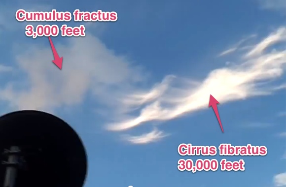
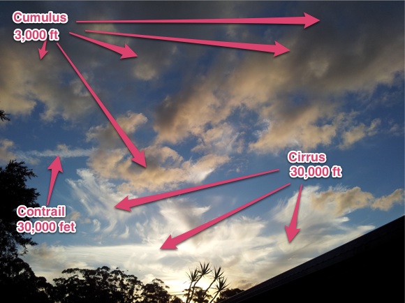
In your video you are seeing two types of cloud: cumulus, and cirrus.
The cumulus clouds are the low dark "puffy" clouds, that you refer to as "regular". They are probably just around 2,000 to 5,000 feet about you.
The cirrus clouds are much higher, probably around 30,000 to 40,000 feet. They are made of ice crystals which slowly descend and the difference in wind speeds at various altitudes makes them streak out like you see.
reply to post by SageBeno
????
Perfectly normal and ordinary clouds, mate.
I mean.....Here, I can help you to learn about some meteorology.
In the video, the clouds more to the "left" of the scene are basically cumulus, or alto cumulus. To the right (the ones you called "weird") are high-level cirrus.
In fact, they look "weird" to you because they are cirrus being affected by high-level wind shearing. This is also a very common occurrence.
That particular configuration of cirrus, when affected in that way, is commonly called a "Mare's Tail".
Like these dozens of examples....
edit on Tue 13 March 2012 by ProudBird because: (no reason
given)
And from your pretty pic:
edit on 13-3-2012 by Uncinus because: (no reason given)
Just normal clouds, 'mare's tails' as some people call them.....with a jet flying by.
In this case seeing is what you want to believe.
In this case seeing is what you want to believe.
I truly believe that these "people" are trying to control the weather & manipulate it - but these are normal clouds. I'm at school and I'm looking
at the SAME EXACT clouds through the window I'm sitting next to. Peace!
Thanks for the explanatiins fuys... Really insightful. Apprectiate it.. Will get the hang of uploading pics soon
reply to post by SageBeno
First pic right after the video with the display bar moved 3/4's to the right: a rectangular cloud. Kind of trippy. The one to the left of it looks like it started out rectangular too. Wonder if the new cubic ice is catching on. Great pictures btb!
First pic right after the video with the display bar moved 3/4's to the right: a rectangular cloud. Kind of trippy. The one to the left of it looks like it started out rectangular too. Wonder if the new cubic ice is catching on. Great pictures btb!
new topics
-
Scientists Find 7 potential Dyson spheres after Scanning 5 million Objects
Space Exploration: 1 hours ago -
Need help understanding the evolution of WHO as a power structure. Shades of the NWO...?
New World Order: 2 hours ago -
The geography of Eden
Religion, Faith, And Theology: 3 hours ago -
US 'Uniparty' officially throws Christians to the lions...
Conspiracies in Religions: 4 hours ago -
REAL ID now a reality
General Conspiracies: 6 hours ago -
'I couldn't cope with Britain anymore': Kurdish man pays smuggler to return him to France
Social Issues and Civil Unrest: 9 hours ago
top topics
-
Oh, Have I got a Goody for You Guys!!!
General Conspiracies: 13 hours ago, 19 flags -
Former Hamas member goes OFF on ‘low grade’ lefty journalist
US Political Madness: 12 hours ago, 13 flags -
Woman In Her 60s Stabbed To Death In London Street By Thief Who Tried To Steal Her Bag.
Social Issues and Civil Unrest: 15 hours ago, 7 flags -
REAL ID now a reality
General Conspiracies: 6 hours ago, 6 flags -
"The Fool" - A short video featuring a harmonica-playing guy blasted by a UFO
Aliens and UFOs: 17 hours ago, 4 flags -
'I couldn't cope with Britain anymore': Kurdish man pays smuggler to return him to France
Social Issues and Civil Unrest: 9 hours ago, 3 flags -
An Apple a Day
General Chit Chat: 12 hours ago, 2 flags -
US 'Uniparty' officially throws Christians to the lions...
Conspiracies in Religions: 4 hours ago, 2 flags -
Scientists Find 7 potential Dyson spheres after Scanning 5 million Objects
Space Exploration: 1 hours ago, 2 flags -
The geography of Eden
Religion, Faith, And Theology: 3 hours ago, 1 flags
active topics
-
Multipal Solar Storms Coming Our Way This Weekend
Fragile Earth • 22 • : texas thinker -
Gov Kristi Noem Shot and Killed "Less Than Worthless Dog" and a 'Smelly Goat
2024 Elections • 181 • : AlongCameaSpider -
"The Fool" - A short video featuring a harmonica-playing guy blasted by a UFO
Aliens and UFOs • 11 • : EduardoLopez -
Post A Funny (T&C Friendly) Pic Part IV: The LOL awakens!
General Chit Chat • 7164 • : baddmove -
Journalism Against Judaism
Middle East Issues • 22 • : NorthOS -
Kirkpatrick vs Fugal - Skinwalker ranch briefing.
Aliens and UFOs • 28 • : Caver78 -
Scientists Find 7 potential Dyson spheres after Scanning 5 million Objects
Space Exploration • 4 • : BeyondKnowledge3 -
Former Hamas member goes OFF on ‘low grade’ lefty journalist
US Political Madness • 8 • : jofafot -
REAL ID now a reality
General Conspiracies • 21 • : RickyD -
Oh, Have I got a Goody for You Guys!!!
General Conspiracies • 54 • : Flyingclaydisk
2