It looks like you're using an Ad Blocker.
Please white-list or disable AboveTopSecret.com in your ad-blocking tool.
Thank you.
Some features of ATS will be disabled while you continue to use an ad-blocker.

The Moon Tower
page: 1share:
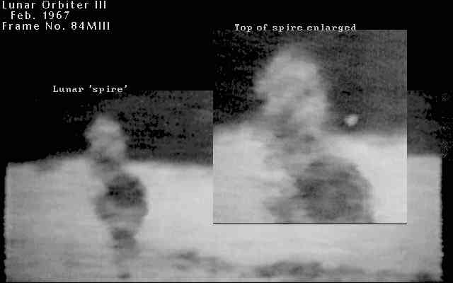
I'm sure many of you have seen the old image of the so called 'Shard' on the Moon from Lunar Orbiter 3 frame 3084.
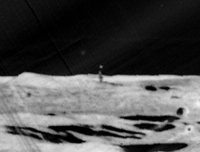
Although an interesting image, i've never really paid much attention to it because of the low quality of the image.
What i've never seen, or heard of, is a second image of this curiosity, but while browsing the LO3 images i noticed the next image from the 'Shard', frame 3085, also has captured what i believe to be the same 'object'!
I have no idea, or opinion, of what this object is, but having seen this second image I can only assume that it really is there and it's not any kind of image processing error.
Here is the original image,
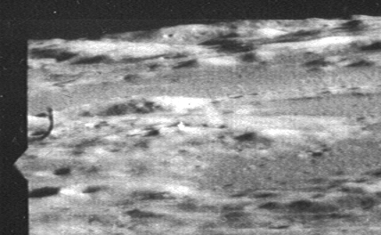
And here is a cropped version with slight enhancement.
Hope some of you find it as interesting as I did!
Although an interesting image, i've never really paid much attention to it because of the low quality of the image.
What i've never seen, or heard of, is a second image of this curiosity, but while browsing the LO3 images i noticed the next image from the 'Shard', frame 3085, also has captured what i believe to be the same 'object'!
I have no idea, or opinion, of what this object is, but having seen this second image I can only assume that it really is there and it's not any kind of image processing error.
Here is the original image,
And here is a cropped version with slight enhancement.
Hope some of you find it as interesting as I did!
Can you point out where the object is in that other picture (image 3085)?
Thanks in advance
Thanks in advance

I must admit when I looked at this picture before, (3085) it seemed to be something on the edge of the camera, looking closer it does appear to be
reflecting light, and at the right angle, must have another look at any other pictures.
edit on 10-3-2012 by smurfy because: Text.
Hmm that is very interesting indeed. Maybe a stage prop they forgot to move
That's interesting, but I've forgotten everything I ever heard about this. Can you give us a sense of scale? 100 feet high? A mile high? 6 miles
high?
Thanks.
Thanks.
reply to post by ReconX
There are some close ups here:
www.thelivingmoon.com...
They call it "the shard."
Its interesting,but I do not think it has to have been built-It could be a rock formation maybe-Sort of like the core of a long eroded mountain.
Although they think its over 1 mile tall...
Dang shame its on the dark side,or we would have seen much better shots by now.
If someone knows the co ordinates,we could look for it on the "clementine lunar image archive."
www.nrl.navy.mil...
reply to post by Ex_CT2
I have no idea what the scale of this can be.
I read that the 'shard' is supposedly over a mile high! I find it hard to get my head around that though!
I have no idea what the scale of this can be.
I read that the 'shard' is supposedly over a mile high! I find it hard to get my head around that though!
reply to post by smurfy
I thought the same, but the shadow does seem to be in sync with the rest of the image.
I thought the same, but the shadow does seem to be in sync with the rest of the image.
I may be wrong but i have read it estimated at seven miles high......!!!
Perhaps this was just sensationalism....definately looks like it couldnt be natural....what would form such a thing considering the forces available are pretty static exept for meteors......
Perhaps this was just sensationalism....definately looks like it couldnt be natural....what would form such a thing considering the forces available are pretty static exept for meteors......
Originally posted by ReconX
reply to post by smurfy
I thought the same, but the shadow does seem to be in sync with the rest of the image.
Yes, although the crater rim and its shadow is in the same part of the picture. But still the object is reflecting light in the right orientation, and it seems about right for at least part of the shadow. 3084's picture seems to have been taken further back and to the left in the field of view leaving the object more in silhouette.
Well, it looks like I have debunked it!
It is a fault on the film. I've looked at other images from the same magazine and I found the 'anomaly' in the same spot on the film in numerous images!
Sorry about that! And thanks for the input!
The search goes on!
www.lpi.usra.edu...
It is a fault on the film. I've looked at other images from the same magazine and I found the 'anomaly' in the same spot on the film in numerous images!
Sorry about that! And thanks for the input!
The search goes on!
www.lpi.usra.edu...
edit on 10-3-2012 by ReconX because: Added link to releated images.
Frame 3084:
Spacecraft Position: Altitude: 46.75 km, Latitude: 1.61°, Longitude: 2.92°
Principal Point: Latitude: 0.80°, Longitude: -1.04°
Frame 3085:
Spacecraft Position: Altitude: 49.07 km, Latitude: 2.52°, Longitude: -1.30°
Principal Point: Latitude: 4.94°, Longitude: -0.34°
Frame 84 was taken on orbit 62. Frame 85 was taken on orbit 63. So, while it was the next frame, it was not exactly in sequence.
Lunar Orbiter 3 was on an nearly equatorial orbit.The principle points of each frame are about 80 miles apart in a nearly north-south orientation. In frame 84 the picture was taken with the camera looking WSW. In frame 85 the camera was looking NE. Here are the spacecraft and principle point locations:
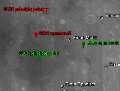
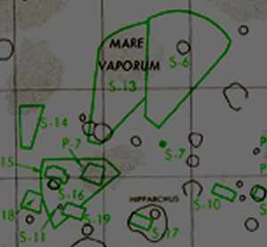
Here is the coverage of each image. Frame 84 is designated as S-11 and frame 85 is designated as S-13.
www.lpi.usra.edu...
Not looking at the same areas. Not looking at actual objects.
Spacecraft Position: Altitude: 46.75 km, Latitude: 1.61°, Longitude: 2.92°
Principal Point: Latitude: 0.80°, Longitude: -1.04°
Frame 3085:
Spacecraft Position: Altitude: 49.07 km, Latitude: 2.52°, Longitude: -1.30°
Principal Point: Latitude: 4.94°, Longitude: -0.34°
Frame 84 was taken on orbit 62. Frame 85 was taken on orbit 63. So, while it was the next frame, it was not exactly in sequence.
Lunar Orbiter 3 was on an nearly equatorial orbit.The principle points of each frame are about 80 miles apart in a nearly north-south orientation. In frame 84 the picture was taken with the camera looking WSW. In frame 85 the camera was looking NE. Here are the spacecraft and principle point locations:
Here is the coverage of each image. Frame 84 is designated as S-11 and frame 85 is designated as S-13.
www.lpi.usra.edu...
Not looking at the same areas. Not looking at actual objects.
On a side note, it just shows how easy it is to miss identify something on the Moon!
I could have sworn it was actually on the Moon!!!
I could have sworn it was actually on the Moon!!!
Originally posted by Phagewww.lpi.usra.edu...
< Bookmarks a new resource>
Thanks Phage!
edit on 10-3-2012 by Saint Exupery because: (no reason given)
In 1994, the US Navy sent the Clementine satellite to the moon on a two month mapping mission. During that time, the satellite took 1.8 million
photographs.
The images from this mission were later used in a project at Arizona State University to piece together all the shots taken from the orbiters of the lunar landing missions. The Clementine map was procured and used as a template for the NASA images.
apollo.sese.asu.edu...
The project, although focusing on the regions of the moon flown over by the landing missions, allows anyone to view any area of the moon mapped by Clementine. When I spent a few hours of inspection of areas outside the Apollo orbiters' range I spotted a few anomalies.
I believe that ASU got hold of unscrubbed images from the Navy since Clementine was a Navy project.
When using the map provided at the site:
The initial choice with which to view the surface is in "lidar" imaging. On the left of the map you will see the word "Background". Under "background" is that word "lidar". Click on "lidar" and other options will appear. Choose "Color".
The Image Map interface gives coordinates for any area being zoomed in on using the cursor over the map to navigate.
Use the zoom tool to zoom in completely. Then right-click on the image and save it. It will save as the zoomed image which can then be further zoomed in on.
The 3 images I found are at the coordinates
1) 55.6 N/ 102.2 E
2) 22.4 S/279.5 E
3) 36.0 N/102.6 E
reply to post by doug r
The link you provided is for the Apollo WMS Image Map. There is nothing there about selecting a "background" but you can select various basemaps (including Clementine imagery). I have no idea where you get LIDAR from. Clementine did not use LIDAR.
The link you provided is for the Apollo WMS Image Map. There is nothing there about selecting a "background" but you can select various basemaps (including Clementine imagery). I have no idea where you get LIDAR from. Clementine did not use LIDAR.
reply to post by Phage
Those sneaky bastages have changed it. Thanks for letting me know.
Anyway...I saved the images. At least they're documented here.
There's nothing at the other end of
apollo.sese.asu.edu...
either. grrrrr
Those sneaky bastages have changed it. Thanks for letting me know.
Anyway...I saved the images. At least they're documented here.
There's nothing at the other end of
apollo.sese.asu.edu...
either. grrrrr
edit on 10-3-2012 by doug r because: (no reason given)
new topics
-
President BIDEN's FBI Raided Donald Trump's Florida Home for OBAMA-NORTH KOREA Documents.
Political Conspiracies: 2 hours ago -
Maestro Benedetto
Literature: 4 hours ago -
Is AI Better Than the Hollywood Elite?
Movies: 4 hours ago -
Las Vegas UFO Spotting Teen Traumatized by Demon Creature in Backyard
Aliens and UFOs: 8 hours ago -
2024 Pigeon Forge Rod Run - On the Strip (Video made for you)
Automotive Discussion: 8 hours ago -
Gaza Terrorists Attack US Humanitarian Pier During Construction
Middle East Issues: 9 hours ago -
The functionality of boldening and italics is clunky and no post char limit warning?
ATS Freshman's Forum: 10 hours ago -
Meadows, Giuliani Among 11 Indicted in Arizona in Latest 2020 Election Subversion Case
Mainstream News: 10 hours ago -
Massachusetts Drag Queen Leads Young Kids in Free Palestine Chant
Social Issues and Civil Unrest: 11 hours ago
top topics
-
President BIDEN's FBI Raided Donald Trump's Florida Home for OBAMA-NORTH KOREA Documents.
Political Conspiracies: 2 hours ago, 23 flags -
Krystalnacht on today's most elite Universities?
Social Issues and Civil Unrest: 14 hours ago, 9 flags -
University of Texas Instantly Shuts Down Anti Israel Protests
Education and Media: 16 hours ago, 8 flags -
Weinstein's conviction overturned
Mainstream News: 12 hours ago, 8 flags -
Supreme Court Oral Arguments 4.25.2024 - Are PRESIDENTS IMMUNE From Later Being Prosecuted.
Above Politics: 14 hours ago, 8 flags -
Massachusetts Drag Queen Leads Young Kids in Free Palestine Chant
Social Issues and Civil Unrest: 11 hours ago, 7 flags -
Gaza Terrorists Attack US Humanitarian Pier During Construction
Middle East Issues: 9 hours ago, 7 flags -
Las Vegas UFO Spotting Teen Traumatized by Demon Creature in Backyard
Aliens and UFOs: 8 hours ago, 6 flags -
Meadows, Giuliani Among 11 Indicted in Arizona in Latest 2020 Election Subversion Case
Mainstream News: 10 hours ago, 5 flags -
2024 Pigeon Forge Rod Run - On the Strip (Video made for you)
Automotive Discussion: 8 hours ago, 4 flags
active topics
-
-@TH3WH17ERABB17- -Q- ---TIME TO SHOW THE WORLD--- -Part- --44--
Dissecting Disinformation • 687 • : Justoneman -
Reason of the Existence
The Gray Area • 21 • : BingoMcGoof -
President BIDEN's FBI Raided Donald Trump's Florida Home for OBAMA-NORTH KOREA Documents.
Political Conspiracies • 10 • : nugget1 -
Supreme Court Oral Arguments 4.25.2024 - Are PRESIDENTS IMMUNE From Later Being Prosecuted.
Above Politics • 85 • : Sookiechacha -
Chris Christie Wishes Death Upon Trump and Ramaswamy
Politicians & People • 24 • : nugget1 -
New whistleblower Jason Sands speaks on Twitter Spaces last night.
Aliens and UFOs • 63 • : pianopraze -
SETI chief says US has no evidence for alien technology. 'And we never have'
Aliens and UFOs • 74 • : Justoneman -
Starburst galaxy M82 - Webb Vs Hubble
Space Exploration • 6 • : Arbitrageur -
University of Texas Instantly Shuts Down Anti Israel Protests
Education and Media • 264 • : stelth2 -
VirginOfGrand says hello
Introductions • 9 • : TheMichiganSwampBuck