It looks like you're using an Ad Blocker.
Please white-list or disable AboveTopSecret.com in your ad-blocking tool.
Thank you.
Some features of ATS will be disabled while you continue to use an ad-blocker.

March 2, 2012: Largest Tornado Outbreak on Record?
page: 7share:
reply to post by eriktheawful
I don't have much to say about dutch.
Those plumes I do believe were fires.
But thats just me.
I don't have much to say about dutch.
Those plumes I do believe were fires.
But thats just me.
My thoughts are with the people of the hit areas. Hope it doesn't take long to get back on your feet considering the harsh economical factors that
are plaguing our world of late. God bless from Ireland
reply to post by eriktheawful
Greetings:
Silly rabbit, we say to ourselves.
Intellicast is one of the half-dozen we constantly monitor at Emergency Operations, and we somehow missed the "signature" rings anyplace else in the CONUS during the same time frame.
Perhaps you might be so kind as to provide even one from the same day elsewhere CONUS that match the configurations in Dutch's video and no weather "anomalies."
Thank you for your time and consideration.
We look forward to your response, as we are here to learn, not necessarily back anything to be found on the 'Tube, or elsewhere, for that matter, unless implicitly implied.
Peace Love Light
tfw
[align=center][color=magenta]Liberty & Equality or Revolution[/align]
Greetings:
These "radar rings" pop up all the time in places, and no severe weather happens every single time.
Don't take my word for it. Use the same link that this "Dutch" fellow uses, and watch radar returns all around the world in real time. You'll see these pop up, and no, there is not always severe weather afterwards:
Silly rabbit, we say to ourselves.
Intellicast is one of the half-dozen we constantly monitor at Emergency Operations, and we somehow missed the "signature" rings anyplace else in the CONUS during the same time frame.
Perhaps you might be so kind as to provide even one from the same day elsewhere CONUS that match the configurations in Dutch's video and no weather "anomalies."
Thank you for your time and consideration.
We look forward to your response, as we are here to learn, not necessarily back anything to be found on the 'Tube, or elsewhere, for that matter, unless implicitly implied.
Peace Love Light
tfw
[align=center][color=magenta]Liberty & Equality or Revolution[/align]
Originally posted by thorfourwinds
~snip~
Perhaps you might be so kind as to provide even one from the same day elsewhere CONUS that match the configurations in Dutch's video and no weather "anomalies."
Sure thing! Dutch himself does it in his very own video: Topeka, Kansas.
He pointed it out: no severe weather occurred there.
And since when is a tornado outbreak a "weather anomaly"? We've been recording these since before humans were even using electromagnetic radiation in any way, shape or form.
I'm sorry, but I can simply NOT take seriously anyone that says, and I quote: "disregard the skeptics"
Science is not about who you want to believe, and who you want to not believe. It's about using the scientific method to go from theory to fact.
To do this, you need to have a hypothesis, that you then evolve into a working theory. From there, you need to have or produce data that can be reproduced by anyone, with repeated conclusive results, that MUST be compared to a control. That last step is so important, because it can show whether or not your data is flawed, or contaminated.
Let's take a look at HAARP: HAARP
Operational frequency is 2.8 Mhz to 10 Mhz at 3.6 MegaWatts, which is the HF frequency band.
Weather radars operate in the SHF frequency bandwidth (3 Ghz to 30 Ghz), and yes, they too are pumping out some power of that RF signal (how do you think a radar works? It's NOT a passive device). Again, the receiver of that radar will not see frequencies outside of it's operational band width. Waveguides for RF propagation will not allow frequencies as low as HAARP even past the feed horn of the antenna, nor can it propagate down the waveguide system itself. The frequencies from HAARP will treat those radar antennas and waveguides as an infinite amount of impedance.
Military radars: many of these have their operational frequencies classified. Some don't or have been declassified over the years. The AN/SPS-48(V)C Radar is a good example of that (I used to work on it). Operational bandwidth: 2.9 Ghz to 4.0 Ghz
You can take a look at these too: AN/SPG-55B was a guided missile radar for the Terrier missile system. Was pretty cool to work on is it was several radars in one: Main pulse radar, guidance and capture radar, and doppler all rolled into one.
The AN/SPS-49 Radar used for tracking surface craft. Or the AN/SPS-10 (which has been replaced by the AN/SPS-67 radar) was a great navigational radar.
AM/FM radio stations, Satellite TV, GPS, Cell Phones....my the list goes on and on (and these right here are transmitting back and forth....well into and through the ionosphere.........).
So conspiracy theorist have a theory that HAARP is being used to change the weather. Okay, it's a theory.
But that is all it is: a theory (and a horrible one at that). If it's more than theory, then let's see some hard data that can be repeated through experiments. Let us see how using RF energy on the ionosphere can affect the weather (never mind that we are already bombarding the ionosphere as it is with every day devices). Please show me how a 3.6 Megawatt RF signal, can create an thunderstorm with up to 10^15th power Joules of energy (very interested in that since you can neither create energy out of nothing, nor destroy it, but only convert it from one form to another). Source
Until then, I'll stick with Occam's Razor, and my years and years of experience with radar systems.
Originally posted by kdog1982
reply to post by eriktheawful
I don't have much to say about dutch.
Those plumes I do believe were fires.
But thats just me.
It should be easy enough to ascertain (with a bit of checking) if fires were indeed burning or not in the specific areas in Arkansas showing the 'plumes'.
Too, I think Dutch is heading in the right *direction* with some of his thoughts on weather mod., maybe not a so called 'expert' as per paper credientials, but anyone looking into something for that long with true intent and spending that much time seems to me to have a 'credential' worth noting, many 'amateur' researchers IMo often bring more light to subjects that many so called 'pros'. less thought entrenched, more open to new ideas and often much less 'to hide' (in many cases.)
Too his thoughts on weather mod seem to follow the trends in Eastlund's patent info, and related white papers, I'm convinced these methods are entirely plausible, and IMo have been used somewhat routinely, whether or not this series of events was created/enhanced/tested I don't know but I'm glad there are folks out there like Dutch and seems now quite a few others some here on ATS that keep an open mind and an eye on what the public would never be told.about if it were occurring.
reply to post by Tecumte
www.arfirenetwork.org...
www.arfirenetwork.org...
The Arkansas Prescribed Fire Network is a cooperative project of the Arkansas Prescribed Fire Council. The purpose of the Network is to provide accurate information on the use and benefits of prescribed fire in Arkansas, provide a place where people can come to find information, post photos, learn about training and equipment locations, and find help getting their own prescribed fires accomplished safely and effectively.
Well, where i'm at it's 92 degrees...and just 2 days ago, it was 60. I'm not sure what's going on, but all those PLANES, flying back and forth,
side by side to each other....leaving trails, which form into clouds; can't be a good thing. 92 degrees, in winter? oooooooh boy! I feel like
a 'show' has begun, and the featured film: "2012" is about to begin. they're PLAYING with the weather.
reply to post by kdog1982
Ok I did find the following from another source:
If I have it correctly (and please add or correct my info as needed) it appears Dutch's 'plume' video is from Thurs. 3-1-12.
It also appears one of the plumes (the northern one?) seems to be in the vicinity of Yell/Logan/Johnson counties though that's just a visual approximation on my part looking at a map, haven't attempted an overlay.
I was able to find presribed burn data from Ark. from this source and it seems to indicate there were prescribed burns scheduled on 3-1-12 one about a 1000 acres the other almost twice that in the Yell/Logan county area.
hotsprings.todaysthv.com...
Thoughts/more details?
edit on 4-3-2012 by Tecumte because: clarity
edit on 4-3-2012 by Tecumte because: sp.
reply to post by eriktheawful
There appear to be some descrepancies regarding HAARP's potential power capabilities. Here's a site claiming not 3+ mega watts but rather 3+ gigawatts (3 billion watts not 3 million).
Another site claims heaters like EISCAT work in the billion watts range and that HAARP is the (one of the? ) most powerful. Wonder how often the military gives out it true capabilities as regards stealth weapons systems?
I wonder what the potential energy release into skies full of susceptible scattered particles could be if we had all of these dozens (hundreds? thousands?) of things aimed and concentrated, or even a sizable part of them along a path to create gradients to move fronts around and energize these systems?
www.haarp.net...
edit on 4-3-2012 by Tecumte because: link added
I just took a look at your links, and rewatched the video. The plumes happen in the counties where the controlled burns were planned (that's what we
call them here).
For those that don't know what we are talking about, forestry commission perform controlled burns for agriculture. They are basically burning large amounts of under brush, as this helps the forest grow, and helps to control wild forest fires from getting out of hand.
These controlled burns will release a very large amount of smoke that is visible to satellite images. He stated on YouTube that those plumes where "not wild fires". In that, he is correct. Controlled burns are NOT wild fires. But fires they are.
The other thing about his video and these plumes: as you can see the satellite track is over several hours. So those plumes of smoke lasted for hours, and if they were visible to the satellite: they would have been VERY visible to people on the ground. And if these were plumes from extinct volcanoes, that would have be a very, very news worthy event. Yet there was not a peep about it.
Sometimes we want something to be true so hard, that we don't stop and think, or take a look at things for ourselves
Originally posted by Tecumte
reply to post by eriktheawful
There appear to be some descrepancies regarding HAARP's potential power capabilities. Here's a site claiming not 3+ mega watts but rather 3+ gigawatts (3 billion watts not 3 million).
Another site claims heaters like EISCAT work in the billion watts range and that HAARP is the (one of the? ) most powerful. Wonder how often the military gives out it true capabilities as regards stealth weapons systems?
I wonder what the potential energy release into skies full of susceptible scattered particles could be if we had all of these dozens (hundreds? thousands?) of things aimed and concentrated, or even a sizable part of them along a path to create gradients to move fronts around and energize these systems?
www.haarp.net...
edit on 4-3-2012 by Tecumte because: link added
Sorry, not to belittle your link, but I'll take the Wikipedia over that web site for now.
Military does not publish the specs of classified systems, no. However, anyone with a good RF sniffer, down range from somewhere can pick up the frequency bandwidth and, bases on power levels at certain distances from the transmission, can tell was the average power output are.
You know, since the frequency bandwidth is 2.5 to 10 Mhz, ANYONE with passing knowledge of electronics and radios, and build a superhetrodyne receiver, with parts from Radio Shack. Seriously. That's such a low bandwidth, that you can modify an old radio to pick up that signal.
So all of you out there that want to monitor HAARP, go out and make your own monitors. It's not that hard.
Originally posted by eriktheawful
I just took a look at your links, and rewatched the video. The plumes happen in the counties where the controlled burns were planned (that's what we call them here).
For those that don't know what we are talking about, forestry commission perform controlled burns for agriculture. They are basically burning large amounts of under brush, as this helps the forest grow, and helps to control wild forest fires from getting out of hand.
These controlled burns will release a very large amount of smoke that is visible to satellite images. He stated on YouTube that those plumes where "not wild fires". In that, he is correct. Controlled burns are NOT wild fires. But fires they are.
The other thing about his video and these plumes: as you can see the satellite track is over several hours. So those plumes of smoke lasted for hours, and if they were visible to the satellite: they would have been VERY visible to people on the ground. And if these were plumes from extinct volcanoes, that would have be a very, very news worthy event. Yet there was not a peep about it.
Sometimes we want something to be true so hard, that we don't stop and think, or take a look at things for ourselves
Well as you can probably tell, as regards me personally, (not part of the *we*) I don't 'want' things to be any certain way, and that's why I worked to actually post the links and info I did to try and find just what the 'truth' of the matter is.
My info may show (as you allude to) that Dutch is simply incorrect in his analysis, as I said too it *looks* like controlled burns *may* well explain Dutch's plumes. An overlay and time signature could reasonably prove 'our' potential explantion and Dutch should be looking into this if he doesn't want to lose credibility.(anyone can get part of the equation wrong though)
However, I do say in his defense I think he is getting 'close' in his hypothesis as to how some forms of weather mod work, but again more research is needed, I don't count on Raytheon sending me a personal email detailing how their latest 'starwars' based systems work.
reply to post by Tecumte
No, I'm afraid that most companies that do contract work for the military are not very forthcoming in the specs of the equipment they build, hehehehe
However, I was serious about if people REALLY want to monitor HAARP, then they can do it themselves in a lot of cases. Everyone already has the best info: The frequency bandwidth of 2.5 to 10 MHz.
The best thing to use is a RF Field Strength Meter set to that bandwidth.
Now all you need is people with these meters spread out all over, and if they start getting spikes in that bandwidth, they can note the time, date, duration and how strong the power was. Then they can report it somewhere that the team has set up to consolidate their information.
Then they can monitor the weather: is anything going on within the next 24 to 48 hours? If so, where? When? and how does it connect to the data obtained by all the people with the RF meters?
You see, what I'm describing above is SERIOUS investigation: not someone looking at weather radar screens, and claiming that false returns and ground clutter is HAARP. Or large smoke plumes from satellite images are from extinct volcanoes, when instead they are from controlled burns being done (since one would of had the media's attention in a flash. Let's face it: extinct volcanoes releasing plumes in the heartland of America? Oh ya, BIG story!).
So that's what I'm saying: if people really think there is something going on: then go out and REALLY investigate it! Don't depend on some guy with a YouTube channel.
reply to post by eriktheawful
I think we will see more 'serious' research as more of these advanced systems and methods come on line and get employed, more researchers will too step up their efforts in the public's effort to know.
As regards HAARP-type heaters though it has been said that when this energy is stored in the atmosphere and then released/bounced back down to earth that the beam coming back down can potentially be extremely powerful but VERY narrow perhaps in the cm? range If so this might prove hard to detect absent being unfortuntely? in the direct path?
Too these systems are said to have the capability to work in 'pulsed' modes radically changing their capabilities and potentials (and potential frequency effects). Gonna take alot of time, energy, and maybe equipment/dollars to try and find what is purposely hidden from the citizenry, let's hope concerned citizens step up to the plate.
As for any Wikipedia entries I suspect that was one of the first 'one stop shopping' places to be comprimised as regards 'sensitive' subjects.
edit on 4-3-2012 by Tecumte because: sp.
Originally posted by kdog1982
reply to post by eriktheawful
I don't have much to say about dutch.
Those plumes I do believe were fires.
But thats just me.
Greetings:
An incredible bit of hail storm footage from Friday’s storms in Ft. Branch, Indiana.
Storm in Fort Branch, Indiana on 3/2/2012. Credit - Mick Rowe-GMODESTROYER.com
Due to the offhand way in which Dutch was dismissed by eriktheawful, and your comment, we looked into this a bit further to satisfy our own curiosity and just for grins, we backtracked and attempted to put a wildfire or controlled burn at one of the plume sites, but to no avail.
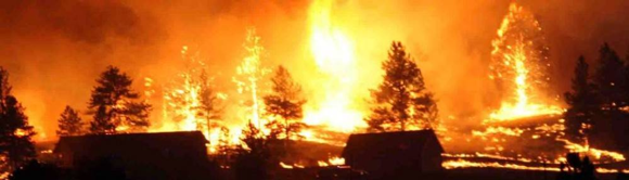
What fires there we found were before the plumes and/or not in the same area. Besides that, forest fires (as in the photo below) do not go out overnight and reappear as described in the video.
The only fires applicable were controlled burns accomplished before 29 February and forest fire smoke plumes don't disappear and reappear as described in this case.
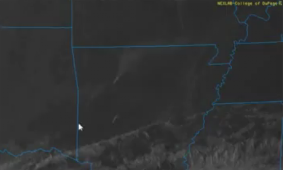
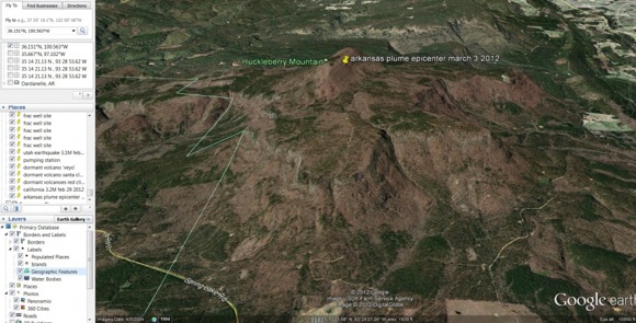
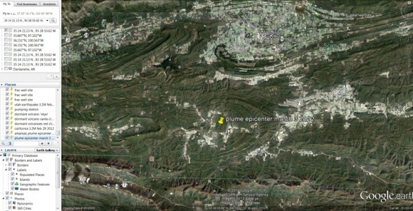
Here are the plumes in Arkansas, matching Huckleberry Ridge and Mount Nebo, neither of which have fires nearby.
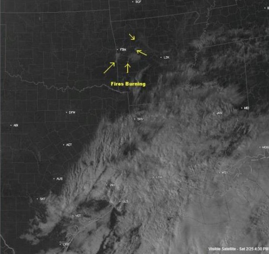
Fires in western Arkansas
KFSM, a television station in Arkansas, tweeted this satellite photo of fires burning in the west Arkansas counties of Le Flore, Logan, Scott and Johnson. It is dated Saturday, February 25 at 4:30 p.m.
The Nature Conservancy's Arkansas field office and the arsenal's Fire and Emergency Services will conduct prescribed and controlled burns beginning Monday and continuing through Feb. 29.
Here are the three largest fires before the date.
(AP-Published: 2/28/12 7:48 am) — Arkansas firefighting crews have been battling numerous wildfires.
For the month, the Arkansas Forestry Commission says crews have responded to almost 50 wildfires. Last weekend, nearly 1,000 acres burned, and another 84 acres burned on Monday.
The commission says single engine air tankers have dropped water on fires in Bradley, Grant and Polk counties.
Unless we really missed something, this eliminates smoke plumes from wildfires as the culprit. We researched this to be able to ask the question again with the field somewhat narrowed... what is it?
Since “this guy Dutch” is in question, this is his follow-up video from today and we would like your assessment.
... new Arkansas plumes today.. video on Huckleberry Ridge and Mount Nebo.. Sulphur Springs and Hot Springs, Arkansas.. these plumes ARE NOT WILDFIRES.. they are plumes from dormant volcanic areas.. dare I say plumes from EXTINCT volcanic areas!!!!!
3/4/2012 — Steaming Plumes appear in Arkansas = DORMANT VOLCANOES BEING FRACKED !
a Fracking (frac well drilling) operation JUST WEST of the Plume area — so all together we have a giant natural gas frack operation — a series of dormant volcanoes, town names like Sulphur Springs, Hot Springs, and Crater of Diamonds/Murfreesboro — the plumes appear on VISIBLE SATELLITE from space.. only for a short time , at MULTIPLE SITES always near sunset… and gone by the AM (thus ruling out a large fire of some kind).
To me, IMO, it has all the pieces there to put together.. a geologic steaming event of some kind … the steam is coming from this dormant volcanic area BEING FRACKED (injected with water) !!!!!
Here are the areas from which the plumes emanate, both inactive volcano sites.
35 14 21.13 N , 93 28 53.62 W location of the most current plume appearing on visible satellite = west of Sulphur Springs AR.
34°46’11.98″N , 94°11’33.94″W location of the 2nd plume (central west Arkansas) near the state line.
Great idea to INJECT WATER into an area permeated with old deep volcanic tubes connected to very old magma chambers... I think it is highly possible that water injected from this nearby fracking operation could indeed cause a STEAM PLUME event to occur at the dormant volcano chain right next door !
Not a good development for the area. This increases the chances of a larger seismic event along the New Madrid Seismic Zone… and may indeed be the VERY CAUSE of our recent midwest earthquake uptick… now there is a DIRECT CONNECTION between fracking / dormant volcanoes / and plumes appearing .
So, if the plumes are not fires, and you distrust Dutch’s prognostication as to them being vented from “inactive volcanoes” and, as such, become precursors to an imminent earthquake; so what are they?
Enquiring minds want to know.
Peace Love Light
tfw
[align=center][color=magenta]Liberty & Equality or Revolution[/align]
reply to post by thorfourwinds
What does this have anything to do with a tornado outbreak?
Time to start a thread about this dutch-non-sense.
Or maybe this thread of it.
www.abovetopsecret.com...
What does this have anything to do with a tornado outbreak?
Time to start a thread about this dutch-non-sense.
Or maybe this thread of it.
www.abovetopsecret.com...
edit on 4-3-2012 by kdog1982 because: (no reason given)
reply to post by thorfourwinds
thanks great info/pics, so I still have these questions though, and let me say I keep an open mind regarding Dutch, his weather accuracy recently seems pretty good and I agree with his assessment of potential weather modification efforts a likely possibility.
But as to this idea of volcanic plumes I have to ask:
1-Wouldn't this have been noticed on the ground and perhaps reported? (as asked in a previous post) Was it?
2- Did I get it right that Dutch's plume vid is from Thurs. 3-1-12?
3-Also, I posted a link showing *scheduled* prescribed burns in Logan/Yell/ Johnson counties on 3-1-12. First is that where the plumes are located, do we have an overlay that could clearly show it, the northern most plume looks 'close' to me visually on a map but I can't tell for sure without overlaying it (and not sure how to do that) Secondly were the burns actually carried out on 3-1-12 and would the time match to the plumes? (I couldn't read the time in the vid)
More research?
Originally posted by kdog1982
reply to post by thorfourwinds
What does this have anything to do with a tornado outbreak?
Time to start a thread about this dutch-non-sense.
Well it might possibly have alot to do with it IF the same techology is being used in whatever way to disrupt Earth's magnetic field. The possibilities for all sorts of disruptions (and eruptions) exist.
Originally posted by kdog1982
reply to post by thorfourwinds
What does this have anything to do with a tornado outbreak?
Time to start a thread about this dutch-non-sense.
Not really. The "plume" video got brought in by someone that was trying to make a cross connection, and then later they posted another video by the same person (Dutch), who was showing radar false rings and trying to connect that to the tornado outbreaks.
_________________________
reply to post by thorfourwinds
Good job and doing some super research yourselves instead of blindly repeating what someone else said in a YouTube video!
There were scheduled controlled burns for March 1, 2012 as tecumte posted:
Prescribed Burns
One of the plumes lines up nicely with the Logan and Yell county burn.
My whole point is that if these plumes were from extinct volcanoes: people on the ground would have noticed. The video of the satellite tracking clearly shows that those plumes lasted for hours.
They would have been very news worthy events, since those volcanoes are extinct (not dormant). So either a LOT of people on the ground are blind. Or your friend Dutch is mistaken.
Do volcanic plumes cause massive tornado outbreaks? No, I don't think they do.
Do they cause earthquakes? The plumes themselves do not. But yes, a extinct volcano starting to erupting can. I used to live in Naples, Italy as a teen, and we used to see plumes from Vesuvio and Sulfatara all the time (they stink too), and we'd get shakes, rattle and rolls.
But I'm still waiting to see a news article about extinct volcanoes releasing plumes in the heartland of the US.
Only thing I could find.
archive.suite101.com...
A volcano in Arkansas? You have got to be kidding! An article published in the Arkansas Gazette on January 15, 1856 created an onslaught of speculation about a volcanic eruption in southeastern Logan County, Arkansas. It wasn't until January 15, 1981, that the Gazette republished the story of the volcano. "...On the third day of December last, a singular noise was heard here. It has been differently described by those who heard it as like a blast in a wall, the explosion of a meteor, or a single distant clap of heavy thunder. So far as ascertained, the nearer the center or place of explosion, there was a rumbling and a sensible vibration of the earth.
archive.suite101.com...
new topics
-
BIDEN Admin Begins Planning For January 2025 Transition to a New President - Today is 4.26.2024.
2024 Elections: 8 minutes ago -
Big Storms
Fragile Earth: 1 hours ago -
Where should Trump hold his next rally
2024 Elections: 4 hours ago -
Shocking Number of Voters are Open to Committing Election Fraud
US Political Madness: 5 hours ago -
Gov Kristi Noem Shot and Killed "Less Than Worthless Dog" and a 'Smelly Goat
2024 Elections: 5 hours ago -
Falkville Robot-Man
Aliens and UFOs: 6 hours ago -
James O’Keefe: I have evidence that exposes the CIA, and it’s on camera.
Whistle Blowers and Leaked Documents: 6 hours ago -
Australian PM says the quiet part out loud - "free speech is a threat to democratic dicourse"...?!
New World Order: 7 hours ago -
Ireland VS Globalists
Social Issues and Civil Unrest: 8 hours ago -
Biden "Happy To Debate Trump"
2024 Elections: 8 hours ago
top topics
-
James O’Keefe: I have evidence that exposes the CIA, and it’s on camera.
Whistle Blowers and Leaked Documents: 6 hours ago, 13 flags -
Blast from the past: ATS Review Podcast, 2006: With All Three Amigos
Member PODcasts: 10 hours ago, 13 flags -
Australian PM says the quiet part out loud - "free speech is a threat to democratic dicourse"...?!
New World Order: 7 hours ago, 12 flags -
Biden "Happy To Debate Trump"
2024 Elections: 8 hours ago, 12 flags -
Mike Pinder The Moody Blues R.I.P.
Music: 10 hours ago, 8 flags -
What is the white pill?
Philosophy and Metaphysics: 10 hours ago, 6 flags -
Shocking Number of Voters are Open to Committing Election Fraud
US Political Madness: 5 hours ago, 6 flags -
RAAF airbase in Roswell, New Mexico is on fire
Aliens and UFOs: 8 hours ago, 5 flags -
Ireland VS Globalists
Social Issues and Civil Unrest: 8 hours ago, 5 flags -
Where should Trump hold his next rally
2024 Elections: 4 hours ago, 4 flags
active topics
-
BIDEN Admin Begins Planning For January 2025 Transition to a New President - Today is 4.26.2024.
2024 Elections • 1 • : Zanti Misfit -
Gov Kristi Noem Shot and Killed "Less Than Worthless Dog" and a 'Smelly Goat
2024 Elections • 38 • : cherokeetroy -
Falkville Robot-Man
Aliens and UFOs • 7 • : KKLOCO -
Big Storms
Fragile Earth • 9 • : nerbot -
"We're All Hamas" Heard at Columbia University Protests
Social Issues and Civil Unrest • 294 • : TheWoker -
Where should Trump hold his next rally
2024 Elections • 15 • : Zanti Misfit -
Gaza Terrorists Attack US Humanitarian Pier During Construction
Middle East Issues • 89 • : AlongCameaSpider -
Post A Funny (T&C Friendly) Pic Part IV: The LOL awakens!
General Chit Chat • 7138 • : baddmove -
Ireland VS Globalists
Social Issues and Civil Unrest • 8 • : nugget1 -
Definitive 9.11 Pentagon EVIDENCE.
9/11 Conspiracies • 428 • : Zanti Misfit