It looks like you're using an Ad Blocker.
Please white-list or disable AboveTopSecret.com in your ad-blocking tool.
Thank you.
Some features of ATS will be disabled while you continue to use an ad-blocker.

Quake Watch 2012
page: 93share:
reply to post by muzzy
Of course originally that was a 6.4 Mw and they downgraded it. See details here
Maybe the seismo is showing the original 6.4 ? (Please no one take that comment as serious)
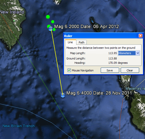
The November one was 50km deep and the latest one was 85km deep so maybe that accounts for some of it. Also oc course this latest one is not 7 days old yet so it will probably be downgraded to 5.9 Mw.
114 km by the way not 60
The latest one does not look so small in BUD: RABL.AU..BHZ.2012.097
Of course originally that was a 6.4 Mw and they downgraded it. See details here
Maybe the seismo is showing the original 6.4 ? (Please no one take that comment as serious)
The November one was 50km deep and the latest one was 85km deep so maybe that accounts for some of it. Also oc course this latest one is not 7 days old yet so it will probably be downgraded to 5.9 Mw.
can 60km really make that much difference in the size of the trace?
114 km by the way not 60
The latest one does not look so small in BUD: RABL.AU..BHZ.2012.097
edit on 8/4/2012 by PuterMan because: (no reason given)
reply to post by PuterMan
Thanks for having a look.
The 60km I was referring to was the depth, I got that off NEIC for the Nov one, but if you are saying it was 50km then there is even less difference and the traces should be about the same,
And that latest one is closer to SNZO (something I didn't measure) so it should be bigger, given the latest one is recorded as 6.2 and the Nov one was 6.1.
I don't get it.
Like you say it may go down later.
I never looked at the LISS Rabaul at the time either, gone now.
REF: 3686885
LAT/LONG: -36.57343 177.20294
UTC: 2012/4/7 22:14:19
NZST: 2012/4/8 10:14:19
DEPTH: 12 km
MAG: 4.716 ML
LOCATION: os, S Ngatoro Basin
Reported as Felt: No
Energy Released: 178.817 tonnes of TNT
but probably more concerning the one after it just north of me ............. Resevoir
REF: 3686908
LAT/LONG: -40.63153 175.48141
UTC: 2012/4/7 23:18:6
NZST: 2012/4/8 11:18:6
DEPTH: 28 km
MAG: 2.668 ML
LOCATION: Mangahao Upper No 1 Reservoir, Shannon 5581
Reported as Felt: No
Energy Released: 0.151 tonnes of TNT
Day 98-2012 NZ
still if you build a reservoir right on a fault line (Northern Ohariu Fault) in the Tararua Mountain Ranges it should be expected to withstand a Mag 6 at least, been there since the 1940's, I put a new roof on the Turbine Building back in 1989, still holding out
edit on 8-4-2012 by muzzy
because: (no reason given)
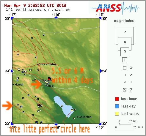
Could there possibly be a 5.0 or larger event inbound for California up to Oregon?
Seems like a lot of spread out tremors in those areas everytime I've gone to the global incident map as of late. With how quiet things have been I just feel the presence of something lurking, ready to blast off when we least expect it. No jinx please Sure has been quiet, though.
Seems like a lot of spread out tremors in those areas everytime I've gone to the global incident map as of late. With how quiet things have been I just feel the presence of something lurking, ready to blast off when we least expect it. No jinx please Sure has been quiet, though.
reply to post by berkeleygal
Whatcha feeling Berk?
I have been away for awhile and catching up.
Has there been an increase in small quakes in the area,maybe some ground movement?
Whatcha feeling Berk?
I have been away for awhile and catching up.
Has there been an increase in small quakes in the area,maybe some ground movement?
reply to post by berkeleygal
good spotting, thats what they call a Mogi (doughnut hypothesis)
Said to occur in Alaska too, over a long period of time though.
Time will tell.
Expecting a 5+ any day now for NZ too.
good spotting, thats what they call a Mogi (doughnut hypothesis)
Said to occur in Alaska too, over a long period of time though.
Time will tell.
Expecting a 5+ any day now for NZ too.
reply to post by murkraz
Never seen anything like it recently. Between Midnight and 10:30 UTC just 4 quakes worldwide above Mag 3.5? Nuts.
There are only 58 of Mag 1.0+
With how quiet things have been
Never seen anything like it recently. Between Midnight and 10:30 UTC just 4 quakes worldwide above Mag 3.5? Nuts.
There are only 58 of Mag 1.0+
edit on 9/4/2012 by PuterMan because: (no reason given)
reply to post by muzzy
I thought that related to larger quakes over decades not small one over a few days. There are many 'circles' of quakes, not least of which is the huge one often seen encompassing Yellowstone and Cascadia and is centred approximately on Malheur Lake.
The other problem with the Mogi hypothesis is that as far as Tokai is concerned, for which it was developed, it has not happened yet. Not sure how many decades on needs to wait but as a prediction method, which is what it is, it seems way to inaccurate and woolly to be of any use.
good spotting, thats what they call a Mogi (doughnut hypothesis)
I thought that related to larger quakes over decades not small one over a few days. There are many 'circles' of quakes, not least of which is the huge one often seen encompassing Yellowstone and Cascadia and is centred approximately on Malheur Lake.
The other problem with the Mogi hypothesis is that as far as Tokai is concerned, for which it was developed, it has not happened yet. Not sure how many decades on needs to wait but as a prediction method, which is what it is, it seems way to inaccurate and woolly to be of any use.
Can someone tell me why the USGS map just changed? I went to check it today, like I do evevryday, and it looks like a dumbed-down version replaced
what was there. I saw the other version as more detailed and informative, this map today looks like something you would present to a third grade
class. Then maybe I'm just grumpy cause they changed what I was familiar with .
But seriously, does anybody know?
But seriously, does anybody know?
reply to post by RoyalBlue
I noticed the map changed this morning. You can zoom in, make adjustments, etc. You can't take in as much at a glance.
I noticed the map changed this morning. You can zoom in, make adjustments, etc. You can't take in as much at a glance.
jeez!
why fix something that ain't broke?
I DO NOT like the new layout at USGS
you reading this USGS?
why fix something that ain't broke?
I DO NOT like the new layout at USGS
you reading this USGS?
reply to post by berkeleygal
I don't like it either. If you look down on the right lower part of page it gives you the option to view the old version.
I would like to revise my first comment. I don't like the map, but I do like that there is more information there on the page instead of having to go to other pages to get further information.
edit on 9-4-2012 by crappiekat because: add comment
What map are you's refering to?
If you mean the "Real Time Maps" off Latest Earthquakes in the World - Past 7 days
which is here , didn't you get the memo?, its been trialed for quite a few months on beta version.
Once you get the hang of it you will find that its far superior to the old World Map, lots of options of how to set it, and off course the list changes with where you look at.
In fact I already forget what the old map looked like, was it that one with hundreds of squares all on top of each other and you couldn't tell what was where?
Only criticism I have is the backgrounds aren't very precise, Google Maps/Satellite/Terrain/Hybrid would have been better.
I guess if you are using DialUp it might be slow?
The 8-30 days list is gone now too. Now just set the slider on "Earthquake Age" to 30, and get the list and map
Probably will have teething trouble with it, Puterman already mentioned the updating/changing details hasn't been consistant, but with the 8-30 List gone now there is nothing to compare with.
reply to post by PuterMan
You must have just been looking at USGS?
or do you mean the day before?
You must have just been looking at USGS?
Reference 3687560
Depth (km) 115.9783
Magnitude 4.628
Date (UTC) 2012-04-09T06:48:09.445Z
NW of Te Anau, NZ
or do you mean the day before?
edit on 9-4-2012 by muzzy because: (no reason given)
The 4th... one 5.5
The 5th... no 5.0 or greater, infact only three 4.5+ quakes
The 6th... the 6.2 in PNG and 5.5 in Indonesia
The 7th... barely globally, a 5.2, 5.0 and 5.8
The 8th... heaps of 2-4.5 mags and just one 5 mag, the 5.4
The 9th... 4 hours to go 'til the 10th and we've only had 4 quakes over a 4.5, no 5s.
What gives, Earth?
Don't get me wrong, I enjoy the quiet, the no lives at risk, but doesn't it just seem like she's either napping the *Spring away, or just severely churning at the stomach.
edit on 9/4/12 by murkraz because: (no reason given)
reply to post by muzzy
Is there anything else other than USGS
Actually if I turn on GeoNet and JMO (but not EMSC) I get this
That is still only 5 above the Mag 4 mark in the last 21 hours.
Is there anything else other than USGS
Actually if I turn on GeoNet and JMO (but not EMSC) I get this
Date/Time UTC,Latitude,Longitude,Magnitude,Depth(Km),Location
2012-04-09 18:48:00, 38.300, 142.100, 3.8, 40.0, Miyagi-Ken Oki
2012-04-09 17:47:52, 63.258, -150.422, 3.5, 123.1, Central Alaska
2012-04-09 08:25:00, 36.000, 140.100, 3.7, 70.0, Ibaraki-Ken Nambu
2012-04-09 06:54:39, 51.336, -179.699, 4.6, 89.7, Andreanof Isls.
2012-04-09 06:48:09, -45.080, 167.374, 4.6, 115.9, Large Burn
2012-04-09 06:43:05, 48.550, 152.787, 4.3, 173.1, Kuril Isls.
2012-04-09 06:01:09, -15.537, 167.433, 4.7, 125.6, Vanuatu
2012-04-09 02:30:25, -5.555, 147.340, 4.8, 222.6, Eastern New Guinea Region. P.N.G
That is still only 5 above the Mag 4 mark in the last 21 hours.
new topics
-
BIDEN Admin Begins Planning For January 2025 Transition to a New President - Today is 4.26.2024.
2024 Elections: 3 hours ago -
Big Storms
Fragile Earth: 5 hours ago -
Where should Trump hold his next rally
2024 Elections: 7 hours ago -
Shocking Number of Voters are Open to Committing Election Fraud
US Political Madness: 8 hours ago -
Gov Kristi Noem Shot and Killed "Less Than Worthless Dog" and a 'Smelly Goat
2024 Elections: 9 hours ago -
Falkville Robot-Man
Aliens and UFOs: 9 hours ago -
James O’Keefe: I have evidence that exposes the CIA, and it’s on camera.
Whistle Blowers and Leaked Documents: 10 hours ago -
Australian PM says the quiet part out loud - "free speech is a threat to democratic dicourse"...?!
New World Order: 11 hours ago -
Ireland VS Globalists
Social Issues and Civil Unrest: 11 hours ago
top topics
-
James O’Keefe: I have evidence that exposes the CIA, and it’s on camera.
Whistle Blowers and Leaked Documents: 10 hours ago, 17 flags -
Australian PM says the quiet part out loud - "free speech is a threat to democratic dicourse"...?!
New World Order: 11 hours ago, 15 flags -
Blast from the past: ATS Review Podcast, 2006: With All Three Amigos
Member PODcasts: 14 hours ago, 13 flags -
Biden "Happy To Debate Trump"
2024 Elections: 12 hours ago, 13 flags -
Ireland VS Globalists
Social Issues and Civil Unrest: 11 hours ago, 10 flags -
Mike Pinder The Moody Blues R.I.P.
Music: 14 hours ago, 8 flags -
BIDEN Admin Begins Planning For January 2025 Transition to a New President - Today is 4.26.2024.
2024 Elections: 3 hours ago, 7 flags -
What is the white pill?
Philosophy and Metaphysics: 13 hours ago, 6 flags -
Shocking Number of Voters are Open to Committing Election Fraud
US Political Madness: 8 hours ago, 6 flags -
Big Storms
Fragile Earth: 5 hours ago, 6 flags
active topics
-
Gov Kristi Noem Shot and Killed "Less Than Worthless Dog" and a 'Smelly Goat
2024 Elections • 63 • : GENERAL EYES -
Mood Music Part VI
Music • 3113 • : MRTrismegistus -
BIDEN Admin Begins Planning For January 2025 Transition to a New President - Today is 4.26.2024.
2024 Elections • 20 • : BustedBoomer -
One Flame Throwing Robot Dog for Christmas Please!
Weaponry • 12 • : worldstarcountry -
RAAF airbase in Roswell, New Mexico is on fire
Aliens and UFOs • 13 • : Ophiuchus1 -
President BIDEN's FBI Raided Donald Trump's Florida Home for OBAMA-NORTH KOREA Documents.
Political Conspiracies • 40 • : BingoMcGoof -
Australian PM says the quiet part out loud - "free speech is a threat to democratic dicourse"...?!
New World Order • 7 • : 19Bones79 -
It takes One to Be; Two to Tango; Three to Create.
Philosophy and Metaphysics • 8 • : Compendium -
Big Storms
Fragile Earth • 16 • : rickymouse -
James O’Keefe: I have evidence that exposes the CIA, and it’s on camera.
Whistle Blowers and Leaked Documents • 14 • : 19Bones79