It looks like you're using an Ad Blocker.
Please white-list or disable AboveTopSecret.com in your ad-blocking tool.
Thank you.
Some features of ATS will be disabled while you continue to use an ad-blocker.

Quake Watch 2012
page: 78share:
They say cities begin to be evacuated.
Reports from Mexico are putting this earthquake at a 6.5 Magnitude lasting as long as 5 Minutes - Thousands have been evacuated from buildings and homes
edit on 20-3-2012 by diamondsmith because: s
reply to post by Anneke
As Puterman pointed out there is the usual magnitude type difference, but here is some more bits and pieces of info on that quake to add to the confusion.
On the magma search data base it comes up as 5.582ML
On Geonet Rapid its 4.7, after 13 automatic attempts and 2 manual reviews
geonet rapid
based on the Felt Reports and the distances from whence they came I'd say it was more than 4.7. There were 4 x 5MM reports, and 417 total.
On the other hand it hardly shows on LISS SNZO (7:00 line) like a Mag 5 would. However the location is on the Pacific Plate, wheras SNZO is on the Australian Plate and may explain that. Thats why SNZO always shows Fiji, Tonga and Vanuatu quakes as quite large traces, they are also on or border the Australian Plate.
As for location, I'd go with the Geonet one at Irene River, that is a hot spot and there are quakes there all the time. USGS are notoriously wrong with locating NZ quakes, they have it about 20km SE, nearer to Lake Te Anau.
Likewise siesme.nc have it way up near Milford Sound.
Graphs?
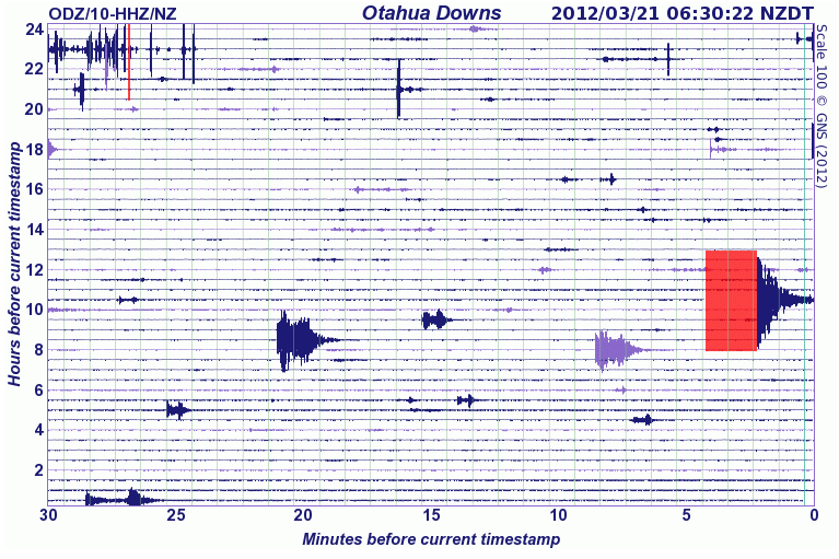
nearest IRIS station nearby is Otahua Downs, inland from Oamaru, Otago,but it doesnt look very big on that ODZ.NZ.10.HHE channel
compared to Geonets ODZ
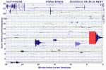
some of the other nearby Geonet stations show quite a big trace too, similar to ODZ
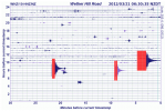
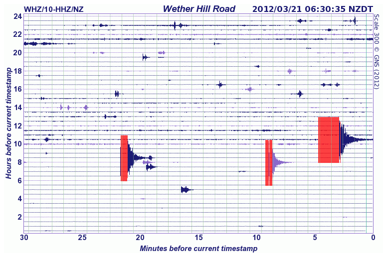
Wether Hill Road, close to Ohai, in Southland
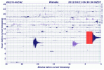
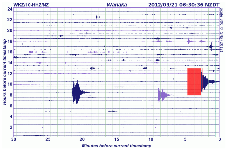
Wanaka, Otago
So for the time being I'd go with Geonets report of 5.6, it may be adjusted after review (in about 30 days) but waddausgsknow
As Puterman pointed out there is the usual magnitude type difference, but here is some more bits and pieces of info on that quake to add to the confusion.
On the magma search data base it comes up as 5.582ML
On Geonet Rapid its 4.7, after 13 automatic attempts and 2 manual reviews
geonet rapid
based on the Felt Reports and the distances from whence they came I'd say it was more than 4.7. There were 4 x 5MM reports, and 417 total.
On the other hand it hardly shows on LISS SNZO (7:00 line) like a Mag 5 would. However the location is on the Pacific Plate, wheras SNZO is on the Australian Plate and may explain that. Thats why SNZO always shows Fiji, Tonga and Vanuatu quakes as quite large traces, they are also on or border the Australian Plate.
As for location, I'd go with the Geonet one at Irene River, that is a hot spot and there are quakes there all the time. USGS are notoriously wrong with locating NZ quakes, they have it about 20km SE, nearer to Lake Te Anau.
Likewise siesme.nc have it way up near Milford Sound.
Graphs?
nearest IRIS station nearby is Otahua Downs, inland from Oamaru, Otago,but it doesnt look very big on that ODZ.NZ.10.HHE channel
compared to Geonets ODZ
some of the other nearby Geonet stations show quite a big trace too, similar to ODZ
Wether Hill Road, close to Ohai, in Southland
Wanaka, Otago
So for the time being I'd go with Geonets report of 5.6, it may be adjusted after review (in about 30 days) but waddausgsknow
edit on
20-3-2012 by muzzy because: (no reason given)
Originally posted by this_is_who_we_are
There's your 188 day quake .
In the event that the 188 day earthquake does succeed (this would be about 25-40 hours too soon), I do hope that this isn't a foreshock to something bigger to come tomorrow, in the Japan sort of sequence.
reply to post by this_is_who_we_are
188 days from when?
The last one which was nearly a seven was on the 14th March. I know my maths is not good but I don't make that 188 days.
Since 188 days
Maybe someone forgot to tell the ones in between that they should not have happened. Sort of spoils the 188 day sequence really.
188 days from when?
The last one which was nearly a seven was on the 14th March. I know my maths is not good but I don't make that 188 days.
Since 188 days
Date/Time UTC,Latitude,Longitude,Magnitude,Depth(Km),Location
2012-03-20 18:02:48, 16.662, -98.187, 7.6, 17.5, Oaxaca. Mexico
2012-02-02 13:34:40, -17.765, 167.134, 7.1, 23.1, Vanuatu
2012-01-10 18:36:59, 2.452, 93.208, 7.2, 20.5, Off W. Coast Of Northern Sumatra
2011-12-14 05:04:57, -7.517, 146.766, 7.1, 121.2, Eastern New Guinea Region. P.N.G
2011-10-23 10:41:21, 38.691, 43.497, 7.1, 16.0, Eastern Turkey
2011-10-21 17:57:16, -28.998, -176.182, 7.4, 32.9, Kermadec Isls. Region
2011-09-15 19:31:02, -21.559, -179.368, 7.3, 626.1, Fiji Region
Maybe someone forgot to tell the ones in between that they should not have happened. Sort of spoils the 188 day sequence really.
edit on 20/3/2012 by PuterMan because: (no reason given)
If it was off shore not a problem,I guess.I wonder when the last big one hit that area if ever.
Originally posted by PuterMan
reply to post by diamondsmith
Some towns right on top of that one. Not good.
No technical details yet.
reply to post by diamondsmith
Based on 100 km radius from the epicentre
Source
WPHASE data just in - Mag 7.3
USGS WPhase Moment Solution
earthquake.usgs.gov...
This is not good. This is normally automated
Based on 100 km radius from the epicentre
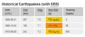
CAT YEAR MO DA ORIG TIME LAT LONG DEP MAGNITUDE IEM DTSVNWG DIST
NFO km
TF
PDE 1975 04 23 111448 16.45 -98.91 11 6.5 UKPAS .F. ....... 80
PDE 1982 06 07 065237.37 16.61 -98.15 40 7.2 MSBRK .DM ....... 7
PDE 1982 06 07 105940.16 16.56 -98.36 33 7.0 MsGS .CM ....... 21
PDE 1984 07 02 045044.13 16.80 -98.44 46 6.5 MSBRK .FM ....... 31
PDE 1993 10 24 075215.63 16.75 -98.72 20 6.7 MwGS 7FM ....... 57
PDE 1995 09 14 140431.43 16.78 -98.60 23 7.4 MwGS .CM ....... 45
PDE 1996 02 25 030815.87 15.98 -98.07 21 7.1 MwGS .FM ....... 76
PDE 1997 07 19 142208.75 16.33 -98.22 33 6.9 MwGS .FM ....... 36
Source
edit on 20/3/2012 by PuterMan because: (no reason given)
WPHASE data just in - Mag 7.3
12/03/20 18:02:48
Epicenter: 16.662 -98.187
MW 7.3
USGS/WPHASE CENTROID MOMENT TENSOR
12/03/20 18:02:48.00
Centroid: 16.262 -97.665
Depth 11 No. of sta: 30
Moment Tensor; Scale 10**19 Nm
Mrr= 6.30 Mtt=-6.17
Mpp=-0.13 Mrt= 8.97
Mrp=-6.92 Mtp= 1.74
Principal axes:
T Val= 13.26 Plg=58 Azm= 47
N = -0.45 9 301
P =-12.81 30 206
Best Double Couple:Mo=1.3*10**20
NP1:Strike=268 Dip=17 Slip= 55
NP2: 124 76 100
USGS WPhase Moment Solution
Alert information for this event is currently under review and will be available soon. Thank you for your patience.
earthquake.usgs.gov...
This is not good. This is normally automated
edit on 20/3/2012 by PuterMan because: (no reason given)
Doesn't look like a 7.9 here, but not sure about the scale on this graph, Vertical scale 400E-6 [1,627,757 counts]
IRIS UNM BHZ:: Unam - Mexico
Different scale on this one, Vertical scale [170,833 counts]?
[url=http://www.iris.edu/servlet/quackquery/plotcache/webicorder_fJRQG.MG..HHE.2012.080.png]MG.JRQG HHE
Juriquilla, Queretaro, Mexico
but looks about the same
IRIS UNM BHZ:: Unam - Mexico
edit on
20-3-2012 by muzzy because: (no reason given)
Different scale on this one, Vertical scale [170,833 counts]?
[url=http://www.iris.edu/servlet/quackquery/plotcache/webicorder_fJRQG.MG..HHE.2012.080.png]MG.JRQG HHE
Juriquilla, Queretaro, Mexico
but looks about the same
edit on 20-3-2012 by muzzy because: (no reason given)
reply to post by PuterMan
No shake map yet.
I guess is not uncommon for the area.
Thank you for that.
Based on 100 km radius from the epicentre
No shake map yet.
I guess is not uncommon for the area.
reply to post by diamondsmith
Not too many people right on top of it.
@muzzy - 7.3 final I think - depends on the centriod tensor.
We have phase data now
neic.usgs.gov...
Shake maps now
earthquake.usgs.gov...
Not too many people right on top of it.
@muzzy - 7.3 final I think - depends on the centriod tensor.
We have phase data now
20 MAR 2012 ( 80)
ot = 18:02:48.95 +/- 1.78 OAXACA, MEXICO
lat = 16.662 +/- 9.7
lon = -98.188 +/- 9.1 MAGNITUDE 7.6 (GS)
dep = 17.5 +/- 4.3
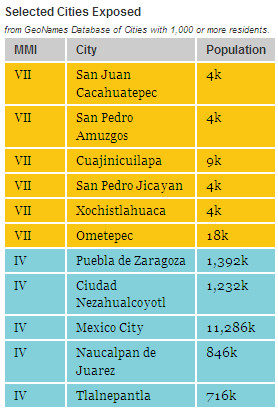
136 km (84 miles) SSW of Huajuapan de Leon, Oaxaca, Mexico (pop 45,000)
162 km (101 miles) WSW of Oaxaca, Oaxaca, Mexico
171 km (106 miles) SE of Chilpancingo, Guerrero, Mexico
322 km (200 miles) SSE of MEXICO CITY, D.F., Mexico
nph = 413 of 425 se = 0.88 FE=058 A
error ellipse = (216.0, 4.0, 15.8;306.0, 0.0, 12.7; 43.0, 85.0, 6.5)
mb = 6.6 (353) ML = 0.0 ( 0) mblg = 0.0 ( 0) md = 0.0 ( 0) MS = 7.3 ( 12)
neic.usgs.gov...
edit on 20/3/2012 by PuterMan because: (no reason
given)
Shake maps now
earthquake.usgs.gov...
edit on 20/3/2012 by PuterMan because: (no reason given)
Magnitude mb 5.0
Region OAXACA, MEXICO
Date time 2012-03-20 18:35:46.0 UTC
Location 16.56 N ; 98.08 W
Depth 60 km
Distances 277 km S Puebla (pop 1,392,099 ; local time 12:35:46.2 2012-03-20)
155 km W Oaxaca (pop 262,566 ; local time 12:35:46.2 2012-03-20)
10 km SE Cacahuatepec (pop 3,636 ; local time 12:35:46.2 2012-03-20)
27 km NW Pinotepa nacional (pop 25,669 ; local time 12:35:46.2 2012-03-20)
EMSC
Starting to show on LISS now SDV (Santo Domingo,
Venezuela)
and some of the US stations
yeah looks like a 7+ there
GFZ have dropped to 7.2 down from 7.7 first try auto recording
geofon.gfz-potsdam.de...
and some of the US stations
yeah looks like a 7+ there
GFZ have dropped to 7.2 down from 7.7 first try auto recording
F-E Region: Near Coast of Guerrero, Mexico
Time: 2012-03-20 18:02:52.0 UTC
Magnitude: 7.2 (Mw)
Epicenter: 98.11°W 16.77°N
Depth: 34 km
Status: M - manually revised
geofon.gfz-potsdam.de...
edit on 20-3-2012 by muzzy because: (no reason given)
reply to post by PuterMan
The rest is history.
I believe this time they escaped with minimal damage and this is the most important thing.
Not too many people right on top of it.
The rest is history.
reply to post by muzzy
GeoAzure 7.4
USGS 7.3 as noted already
GeoFon 7.2
Come on guys, you are not trying. We can get this below 7 if we really try.
reply to post by diamondsmith
GeoAzure 7.4
USGS 7.3 as noted already
GeoFon 7.2
Come on guys, you are not trying. We can get this below 7 if we really try.
reply to post by diamondsmith
edit on 20/3/2012 by PuterMan because: (no reason given)
reply to post by PuterMan
That GeoAzure's a new one.
The Mexican site isn't working off your QVS link page BTW, not sure if the address has changed or its just overloaded.
That GeoAzure's a new one.
The Mexican site isn't working off your QVS link page BTW, not sure if the address has changed or its just overloaded.
.
Unable to connect
Firefox can't establish a connection to the server at www.ssn.unam.mx.
reply to post by muzzy
USA, New Mexico, Albuquerque [IU]
Thanks, I will check it out.
Looks like overload to me. I will wait til things die down a bit and check it again.
Closest realtime seismo UNM.G.00.BHZ.2012.080
USA, New Mexico, Albuquerque [IU]
Thanks, I will check it out.
Looks like overload to me. I will wait til things die down a bit and check it again.
edit on 20/3/2012 by PuterMan because: (no reason
given)
Closest realtime seismo UNM.G.00.BHZ.2012.080
edit on 20/3/2012 by PuterMan because: (no reason given)
USGS have reduced to 7.4 Mw
This is a YELLOW pager alert for fatalities and economic losses.
earthquake.usgs.gov...
This is a YELLOW pager alert for fatalities and economic losses.
earthquake.usgs.gov...
edit on 20/3/2012 by PuterMan because: (no reason given)
reply to post by PuterMan
I went in through a side door
they are saying 7.8
www2.ssn.unam.mx...
graph of the quake PL HHZ
having problems with their maps, need the API key
I went in through a side door
they are saying 7.8
:: NUM. EVENTO 3
:: FECHA 2012-03-20
:: HORA 12:02:50
:: LATITUD 16.42
:: LONGITUD -98.36
:: PROFUNDIDAD 15
:: MAGNITUD 7.8
:: EPICENTRO 29 km al SUR de OMETEPEC, GRO
www2.ssn.unam.mx...
graph of the quake PL HHZ
having problems with their maps, need the API key
edit on 20-3-2012 by muzzy because: (no reason given)
edit on 20-3-2012 by
muzzy because: (no reason given)
reply to post by muzzy
Side door added to the listings
Thanks muzzy.
TV reports are not saying anything about fatalities yet.
Side door added to the listings
Thanks muzzy.
TV reports are not saying anything about fatalities yet.
edit on 20/3/2012 by PuterMan because: (no reason given)
new topics
-
BIDEN Admin Begins Planning For January 2025 Transition to a New President - Today is 4.26.2024.
2024 Elections: 2 hours ago -
Big Storms
Fragile Earth: 3 hours ago -
Where should Trump hold his next rally
2024 Elections: 6 hours ago -
Shocking Number of Voters are Open to Committing Election Fraud
US Political Madness: 7 hours ago -
Gov Kristi Noem Shot and Killed "Less Than Worthless Dog" and a 'Smelly Goat
2024 Elections: 7 hours ago -
Falkville Robot-Man
Aliens and UFOs: 8 hours ago -
James O’Keefe: I have evidence that exposes the CIA, and it’s on camera.
Whistle Blowers and Leaked Documents: 8 hours ago -
Australian PM says the quiet part out loud - "free speech is a threat to democratic dicourse"...?!
New World Order: 9 hours ago -
Ireland VS Globalists
Social Issues and Civil Unrest: 10 hours ago -
Biden "Happy To Debate Trump"
2024 Elections: 10 hours ago
top topics
-
James O’Keefe: I have evidence that exposes the CIA, and it’s on camera.
Whistle Blowers and Leaked Documents: 8 hours ago, 17 flags -
Australian PM says the quiet part out loud - "free speech is a threat to democratic dicourse"...?!
New World Order: 9 hours ago, 15 flags -
Blast from the past: ATS Review Podcast, 2006: With All Three Amigos
Member PODcasts: 12 hours ago, 13 flags -
Biden "Happy To Debate Trump"
2024 Elections: 10 hours ago, 12 flags -
Ireland VS Globalists
Social Issues and Civil Unrest: 10 hours ago, 9 flags -
Mike Pinder The Moody Blues R.I.P.
Music: 13 hours ago, 8 flags -
What is the white pill?
Philosophy and Metaphysics: 12 hours ago, 6 flags -
Shocking Number of Voters are Open to Committing Election Fraud
US Political Madness: 7 hours ago, 6 flags -
RAAF airbase in Roswell, New Mexico is on fire
Aliens and UFOs: 10 hours ago, 5 flags -
Where should Trump hold his next rally
2024 Elections: 6 hours ago, 5 flags
active topics
-
RAAF airbase in Roswell, New Mexico is on fire
Aliens and UFOs • 11 • : Ophiuchus1 -
SETI chief says US has no evidence for alien technology. 'And we never have'
Aliens and UFOs • 79 • : SchrodingersRat -
Gold and silver prices....woo hoo
History • 88 • : SchrodingersRat -
University of Texas Instantly Shuts Down Anti Israel Protests
Education and Media • 314 • : Schmoe3755 -
BIDEN Admin Begins Planning For January 2025 Transition to a New President - Today is 4.26.2024.
2024 Elections • 10 • : BingoMcGoof -
President BIDEN's FBI Raided Donald Trump's Florida Home for OBAMA-NORTH KOREA Documents.
Political Conspiracies • 39 • : AwakeNotWoke -
Gov Kristi Noem Shot and Killed "Less Than Worthless Dog" and a 'Smelly Goat
2024 Elections • 55 • : AwakeNotWoke -
Big Storms
Fragile Earth • 13 • : AwakeNotWoke -
SHORT STORY WRITERS CONTEST -- April 2024 -- TIME -- TIME2024
Short Stories • 26 • : Encia22 -
Biden "Happy To Debate Trump"
2024 Elections • 50 • : Lumenari