It looks like you're using an Ad Blocker.
Please white-list or disable AboveTopSecret.com in your ad-blocking tool.
Thank you.
Some features of ATS will be disabled while you continue to use an ad-blocker.

Quake Watch 2012
page: 200share:
reply to post by SpaceJockey1
has happened;
most of my dreams are about future warm sunny weather lately
has happened;
Date/Time: 1983/10/28 14:6:9.72
Lat: 44.086 Long: -113.805
Region: Borah Peak, Idaho, USA
Magnitude:
M 7.0 [gsx] Mw 7.0 [hrv]
Mw 6.9 GS Mw 7.0 [p&s]
Depth: 16 km
Deaths: 2 Injuries: 2
Tsunami: n/a
Catalog Source: ehb
This earthquake caused two deaths in Challis, about 200 kilometers northeast of Boise, and an estimated $12.5 million in damage in the Challis-Mackay area. Spectacular surface faulting was associated with this earthquake - a 34-kilometer-long northwest-trending zone of fresh scarps and ground breakage on the southwest slope of the Lost River Range. The most extensive breakage occurred along the 8-kilometer zone between West Spring and Cedar Creek. Here, the ground surface was shattered into randomly tilted blocks several meters in width.
At Mackay, about 80 kilometers southeast of Challis, most of the commercial structures on Main Street were damaged to some extent; building inspectors condemned eight of them. Damaged buildings were mainly of masonry construction, including brick, concrete block, or stone. Visible damage consisted of severe cracking or partial collapse of exterior walls, cracking of interior walls, and separation of ceilings and walls at connecting corners. About 90 percent of the residential chimneys were cracked, twisted, or collapsed.
At Challis, less damage to buildings and chimneys was sustained, but two structures were damaged extensively: the Challis High School and a vacant concrete-block building (100 years old) on Main Street. Many aftershocks occurred through 1983. Also felt in parts in Montana, Nevada, Oregon, Utah, Washington, Wyoming, and in the Provinces of Alberta, British Columbia, and Saskatchewan, Canada.
most of my dreams are about future warm sunny weather lately
reply to post by muzzy
Oh blimey!
And coming up for that magic approx 30 year quakeversary period!
Yeh,that weather has been cr*p for sure and dreaming of sunny days is about all one can look forward to, but thankfully most of my dreams nowdays are of an erotic nature, which warm me up fine
Oh blimey!
And coming up for that magic approx 30 year quakeversary period!
Yeh,that weather has been cr*p for sure and dreaming of sunny days is about all one can look forward to, but thankfully most of my dreams nowdays are of an erotic nature, which warm me up fine
reply to post by muzzy
Good God Muzzy, I nearly pissed myself when I saw that!
Jeez, next time bold the date, would ya.
This late at night, scanning along before sleep and not really paying much attention, is not a good idea on my part.
@SJ - I hope your dreams do not come to reality, but I do take notice when you post about them.
reply to post by dreamfox1
What is it saying?
I thought "today" 22nd Aug JST was just pretty normal
mag
What is it saying?
I thought "today" 22nd Aug JST was just pretty normal
mag
reply to post by JohnVidale
Thanks, John.
To be honest, if we boil down that rather lengthy pdf, they basically say the same thing you did!
Thanks, John.
To be honest, if we boil down that rather lengthy pdf, they basically say the same thing you did!
reply to post by muzzy
No, you do enough work, I'm just teasing. I was just reading along and thought you were confirming his prediction.
I learned my lesson to pay better attention to what I am reading though.
Keep up the good work,
No, you do enough work, I'm just teasing. I was just reading along and thought you were confirming his prediction.
I learned my lesson to pay better attention to what I am reading though.
Keep up the good work,
[i further to post by muzzy
I've updated Japan this morning, data is up to about an hour ago. eqarchivesj.wordpress.com...
2 x 5's (in UTC 22nd Aug) 5.6ML and a 5.4ML
5.6-22/08/2012 01:33:06, 42.3454 143.0464, 57, Hiroo District, Hokkaido Prefecture, Japan:
5.4-22/08/2012 05:57:58, 29.6305 139.1861, 497.1, SW of Tori-shima Isl., Izu Islands, Japan
although UGS are being stingy, calling them a 5.0 and a 4.4
5.0mb (4.7ML*) 2012/08/22 01:33:05 42.390 142.966 53.2 HOKKAIDO, JAPAN REGION
4.4mb (4.6ML*) 2012/08/22 05:58:01 29.666 138.753 433.4 IZU ISLANDS, JAPAN REGION
*the ML reading comes from the ugs phase data
And todays selection from the discounted earthquake pile is............
Source: QVSData program
This is the quake otherwise known as
]http://files.abovetopsecret.com/images/member/f3c361360076.jpg
USGS details page
9 or 10 days (could be 9 as I did not check yesterday)
Data file downloaded 001233
Bad lines encountered: 0
Additions to database: 32
Corrections to records: 128
Count of lines: 1098
Magnitude 6+ earthquakes downgraded: 1
Magnitude 5 or 6+ earthquakes upgraded: 0
------------------------------------------------------------------
Downgraded quake
us|b000bv81|?|Sunday, August 12, 2012 10:47:06 UTC|35.66|82.518|6.2|13|?|282km SE of Hotan, China
Log closed 001240
Source: QVSData program
This is the quake otherwise known as
2012-08-12 10:47:06, 35.660, 82.518, 6.2, 13.0, Xinjiang-Xizang Border Region [Map]
]http://files.abovetopsecret.com/images/member/f3c361360076.jpg
USGS details page
9 or 10 days (could be 9 as I did not check yesterday)
edit on 22/8/2012 by PuterMan because: to fix a tag
reply to post by PuterMan
Didn't pay much attention to that one at the time, I see from your QVS page that it was a 6.3 originally.
Not sure when GCMT came out with the CMT or if they have altered it too?
Only just started checking GCMT lately myself.
201208121047A XIZANG
Still showing 6.3Mw on the UGS technical page earthquake.usgs.gov...-tensor
I need to study up about these beach balls, and how they work
3 different versions for this one quake (2 match, GCMT and NEIC Mwb)
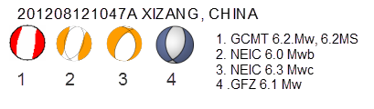
I thought GCMT would be better bet than UGS, and give a definitive magnitude,
but in fact all it does is raise more questions
Didn't pay much attention to that one at the time, I see from your QVS page that it was a 6.3 originally.
Not sure when GCMT came out with the CMT or if they have altered it too?
Only just started checking GCMT lately myself.
Date: 2012/ 8/12 Centroid Time: 10:47:15.9 GMT
Lat= 35.93 Lon= 82.56
Depth= 17.9 Half duration= 3.1
Centroid time minus hypocenter time: 9.7
Moment Tensor: Expo=25 -2.200 -0.657 2.860 0.095 -0.548 0.592
Mw = 6.2 mb = 0.0 Ms = 6.3 Scalar Moment = 2.64e+25
Fault plane: strike=197 dip=40 slip=-79
Fault plane: strike=3 dip=51 slip=-99
201208121047A XIZANG
Still showing 6.3Mw on the UGS technical page earthquake.usgs.gov...-tensor
I need to study up about these beach balls, and how they work
3 different versions for this one quake (2 match, GCMT and NEIC Mwb)
I thought GCMT would be better bet than UGS, and give a definitive magnitude,
but in fact all it does is raise more questions
reply to post by muzzy
Welcome to the world of science where there is no such thing as a consensus unless you are angling for a grant in the area of climate change.
Beach balls - very interesting topic
But seriously,
A geologists eye view of the Van Earthquake discusses beachballs and is particularly relevant to the comments you made about the Iranian quakes being connected.
The USGS page on beachballs I found at best difficult and at worst obscure.
The USGS do however have quite a useful ppt - and in it a link to this
I may have already mentioned this one before - Wolfram Earthquake Focal Mechanism which won't run on Firefox for me but does in Chrome.
Somewhere in my huge selection of drag and lose or save and lose pdf files I have several more documents on beachballs, one of which is this one: Focal mechanisms which is technical and mathematical and really good for getting to sleep at night if you have a need for that.
If I find some more on my drives amongst the 70,000 or so pdf files I will try and find the links for them and post them.
The doggie found some stuff while I was writing. Not sure of the source of these as they were in my Iran folder. Possibly Wikipedia.


Again the doggie cam up with another. 250 pages! Open-File Report 86 - 285A. I think this is the source for it pubs.usgs.gov/of/1986/0285a/report.pdf. Yes that is the one.
That should keep you busy for a while! There is another very good one but at present it eludes me. I do wish these people would name things properly, or that I would remember to do so!!!!!
I thought GCMT would be better bet than UGS, and give a definitive magnitude, but in fact all it does is raise more questions
Welcome to the world of science where there is no such thing as a consensus unless you are angling for a grant in the area of climate change.
Beach balls - very interesting topic
But seriously,
A geologists eye view of the Van Earthquake discusses beachballs and is particularly relevant to the comments you made about the Iranian quakes being connected.
The USGS page on beachballs I found at best difficult and at worst obscure.
The USGS do however have quite a useful ppt - and in it a link to this
I may have already mentioned this one before - Wolfram Earthquake Focal Mechanism which won't run on Firefox for me but does in Chrome.
Somewhere in my huge selection of drag and lose or save and lose pdf files I have several more documents on beachballs, one of which is this one: Focal mechanisms which is technical and mathematical and really good for getting to sleep at night if you have a need for that.
If I find some more on my drives amongst the 70,000 or so pdf files I will try and find the links for them and post them.
The doggie found some stuff while I was writing. Not sure of the source of these as they were in my Iran folder. Possibly Wikipedia.


Again the doggie cam up with another. 250 pages! Open-File Report 86 - 285A. I think this is the source for it pubs.usgs.gov/of/1986/0285a/report.pdf. Yes that is the one.
That should keep you busy for a while! There is another very good one but at present it eludes me. I do wish these people would name things properly, or that I would remember to do so!!!!!
edit on 24/8/2012 by PuterMan because: Darn it can I not get just ONE post without a spelling error? Humph!
Originally posted by tracehd1
Dept. of interior gives news conference on va quake and?
www.youtube.com...
If it wasn't a DUMB snafu, then it was an act of God. I'm not sure which to credit, but I know that they would prefer that their precious hidey hole was smashed by man, than have God disrupt the Washington monument and some MIC church spires, for all to see. I'm guessing it was a bit of both. Those are the ones that scare the crap out of them.
edit on 24-8-2012 by davidmann because: (no reason given)
edit on 24-8-2012 by
davidmann because: (no reason given)
Increasing magnitudes in Kermadec, the spot I had called attention to previously somewhere in this thread.
MAP 5.8 2012/08/24 10:01:53 -33.288 -179.424 33.8 SOUTH OF THE KERMADEC ISLANDS
MAP 5.7 2012/08/24 04:43:49 -27.179 -176.728 20.5 KERMADEC ISLANDS REGION
earthquake.usgs.gov...
Let's hope these two relieved the stresses, and no bigger one ensues.
MAP 5.8 2012/08/24 10:01:53 -33.288 -179.424 33.8 SOUTH OF THE KERMADEC ISLANDS
MAP 5.7 2012/08/24 04:43:49 -27.179 -176.728 20.5 KERMADEC ISLANDS REGION
earthquake.usgs.gov...
Let's hope these two relieved the stresses, and no bigger one ensues.
reply to post by PuterMan
Many thanks, yes that will keep me reading for a while. I found the UGS page myself previously but found it pretty unhelpful too.
this image I can understand, white means down, black means up, thats simple enough
files.abovetopsecret.com...
Looking back at the 4 beach balls I showed for China I can see they are basically the same, its the Nodal point that seems to vary between the Networks
edit on 24-8-2012 by muzzy because: (no reason given)
reply to post by TrueAmerican
yeah a few down south too Balleny Islands region, bit of activity on LISS SNZO after weeks of nothing to see.
PP on the move to the west?
SNZO graph
going by the beach balls on Geofon the Kerms are Reverse Thrust Faulting and the Balleny are Strike Slip, therefore the Pacific Plate went west (as it is supposed to do)
LDEO had a few earlier in the week to the SE as well
In fact it has been REALLY quiet here in NZ, on the 20th and 23rd Aug no quakes recorded ( published) at all by Geonet 9 all up all week since Monday
actually the geonet guys/gals must have fallen asleep at the controls the seismos are showing plenty of activity, at least for the last 24hrs
www.geonet.org.nz...
yeah a few down south too Balleny Islands region, bit of activity on LISS SNZO after weeks of nothing to see.
PP on the move to the west?
SNZO graph
going by the beach balls on Geofon the Kerms are Reverse Thrust Faulting and the Balleny are Strike Slip, therefore the Pacific Plate went west (as it is supposed to do)
LDEO had a few earlier in the week to the SE as well
2012 8 24 11 6 48.0 -61.75 153.75 33.0 5.2 BALLENY ISLANDS REGION
2012 8 24 10 2 0.0 -33.25 -179.25 33.0 5.6 SOUTH OF KERMADEC ISLANDS
2012 8 24 7 3 12.0 -63.75 170.75 33.0 5.5 BALLENY ISLANDS REGION
2012 8 22 11 13 28.0 -62.75 -158.75 33.0 5.1 PACIFIC-ANTARCTIC RIDGE
2012 8 21 6 28 24.0 -56.25 -144.75 33.0 4.9 PACIFIC-ANTARCTIC RIDGE
In fact it has been REALLY quiet here in NZ, on the 20th and 23rd Aug no quakes recorded ( published) at all by Geonet 9 all up all week since Monday
edit on 24-8-2012 by muzzy because: (no reason given)
actually the geonet guys/gals must have fallen asleep at the controls the seismos are showing plenty of activity, at least for the last 24hrs
www.geonet.org.nz...
edit on 24-8-2012 by muzzy because: (no reason given)
Hmmmm
I had a look at Geonet News and found this
Well I seriously have my doubts about switching everything to the Automated system so quickly. For a few weeks I cross referenced Geonet Rapid with the Magma Database a few days afterwards and the number of Auto quakes confirmed was a VERY LOW %, something like 10-15% from memory.
Having in the meantime achieved access to Japans NEID where they have both Automated up to date data and confirmed data 4 days later I have noticed the differences are also quite major there too. Basically with Japan they tend to over estimate magnitude size in Auto mode, and under list as far as quantity goes, some days when I have brought up the confirmed data the number of quakes per day has doubled.
I'm a bit angry with myself for getting distracted on Japan, the NZ Geonet Rapid only gives out the last 30 quakes, so if you miss a download there is no database to go back to to get the days you missed.
I missed the 16th through to the 19th Aug Geonet Rapid data
I think I'll just stick to Networks that have decent databases, dump LDEO, Geonet Rapid, Japan Auto and just concentrate on Geofon (one of the easiest to negotiate through), Japans JMA and RAS. Whether my NZ pages keeps going depends on what they start feeding into the Magma database from Sept 1st.
also
Geez us you mean I have to update those a 4th time
I had a look at Geonet News and found this
If you're a user of GeoNet recent earthquakes web services then it's time to start updating your code to use the new web services from GeoNet Rapid. We are aiming to put GeoNet Rapid into full production in early September 2012. At this time the web services currently available on www.geonet.org.nz will be replaced by those from GeoNet Rapid.
You can either wait until after GeoNet Rapid goes live in September or start using the new services now. When GeoNet Rapid goes live and replaces the content at www.geonet.org.nz we will keep the beta.geonet.org.nz CNAME pointing at www.geonet.org.nz to give users a chance to change their code from using beta.geonet.org.nz to www.geonet.org.nz.
You can learn more about the new services here:
beta.geonet.org.nz...
beta.geonet.org.nz...
This does not affect earthquake web services provided by magma.geonet.org.nz producing output in QuakeML and KML. These will continue to provide access to the catalogue of New Zealand earthquakes. The catalogue is currently being finalised for all earthquakes up until December 31 2011 (including a backlog period from 2008 and the mainshock sequences for Dusky Sound 2009 and Darfield 2010). We hope to have this work completed early in 2013. A catalogue produced by our new earthquake location system SeisComP3 will cover earthquakes occurring after January 1 2012.
Well I seriously have my doubts about switching everything to the Automated system so quickly. For a few weeks I cross referenced Geonet Rapid with the Magma Database a few days afterwards and the number of Auto quakes confirmed was a VERY LOW %, something like 10-15% from memory.
Having in the meantime achieved access to Japans NEID where they have both Automated up to date data and confirmed data 4 days later I have noticed the differences are also quite major there too. Basically with Japan they tend to over estimate magnitude size in Auto mode, and under list as far as quantity goes, some days when I have brought up the confirmed data the number of quakes per day has doubled.
I'm a bit angry with myself for getting distracted on Japan, the NZ Geonet Rapid only gives out the last 30 quakes, so if you miss a download there is no database to go back to to get the days you missed.
I missed the 16th through to the 19th Aug Geonet Rapid data
I think I'll just stick to Networks that have decent databases, dump LDEO, Geonet Rapid, Japan Auto and just concentrate on Geofon (one of the easiest to negotiate through), Japans JMA and RAS. Whether my NZ pages keeps going depends on what they start feeding into the Magma database from Sept 1st.
also
The catalogue is currently being finalised for all earthquakes up until December 31 2011 (including a backlog period from 2008 and the mainshock sequences for Dusky Sound 2009 and Darfield 2010)
Geez us you mean I have to update those a 4th time
edit on 24-8-2012 by muzzy because: (no reason given)
I grew up in the area where the last earthquake 3.3 in Colorado was the other day. The earthquake is only 10 miles from the Dotsero volcano. Almost
due south. Do you think that there could be any connection? Here is a couple links. Any input appreciated.
www.volcanodiscovery.com...
www.volcano.si.edu...
Do not yet know how to post pic yet.
www.volcanodiscovery.com...
www.volcano.si.edu...
Do not yet know how to post pic yet.
new topics
-
President BIDEN's FBI Raided Donald Trump's Florida Home for OBAMA-NORTH KOREA Documents.
Political Conspiracies: 3 hours ago -
Maestro Benedetto
Literature: 5 hours ago -
Is AI Better Than the Hollywood Elite?
Movies: 5 hours ago -
Las Vegas UFO Spotting Teen Traumatized by Demon Creature in Backyard
Aliens and UFOs: 8 hours ago -
2024 Pigeon Forge Rod Run - On the Strip (Video made for you)
Automotive Discussion: 9 hours ago -
Gaza Terrorists Attack US Humanitarian Pier During Construction
Middle East Issues: 10 hours ago -
The functionality of boldening and italics is clunky and no post char limit warning?
ATS Freshman's Forum: 11 hours ago -
Meadows, Giuliani Among 11 Indicted in Arizona in Latest 2020 Election Subversion Case
Mainstream News: 11 hours ago
top topics
-
President BIDEN's FBI Raided Donald Trump's Florida Home for OBAMA-NORTH KOREA Documents.
Political Conspiracies: 3 hours ago, 25 flags -
Krystalnacht on today's most elite Universities?
Social Issues and Civil Unrest: 15 hours ago, 9 flags -
University of Texas Instantly Shuts Down Anti Israel Protests
Education and Media: 17 hours ago, 8 flags -
Weinstein's conviction overturned
Mainstream News: 13 hours ago, 8 flags -
Supreme Court Oral Arguments 4.25.2024 - Are PRESIDENTS IMMUNE From Later Being Prosecuted.
Above Politics: 14 hours ago, 8 flags -
Massachusetts Drag Queen Leads Young Kids in Free Palestine Chant
Social Issues and Civil Unrest: 12 hours ago, 7 flags -
Gaza Terrorists Attack US Humanitarian Pier During Construction
Middle East Issues: 10 hours ago, 7 flags -
Las Vegas UFO Spotting Teen Traumatized by Demon Creature in Backyard
Aliens and UFOs: 8 hours ago, 6 flags -
Meadows, Giuliani Among 11 Indicted in Arizona in Latest 2020 Election Subversion Case
Mainstream News: 11 hours ago, 5 flags -
2024 Pigeon Forge Rod Run - On the Strip (Video made for you)
Automotive Discussion: 9 hours ago, 4 flags
active topics
-
President BIDEN's FBI Raided Donald Trump's Florida Home for OBAMA-NORTH KOREA Documents.
Political Conspiracies • 15 • : AwakeNotWoke -
Is AI Better Than the Hollywood Elite?
Movies • 13 • : Justoneman -
Hate makes for strange bedfellows
US Political Madness • 47 • : 19Bones79 -
-@TH3WH17ERABB17- -Q- ---TIME TO SHOW THE WORLD--- -Part- --44--
Dissecting Disinformation • 689 • : daskakik -
University of Texas Instantly Shuts Down Anti Israel Protests
Education and Media • 265 • : Astrocometus -
Gaza Terrorists Attack US Humanitarian Pier During Construction
Middle East Issues • 27 • : ToneD -
Reason of the Existence
The Gray Area • 21 • : BingoMcGoof -
Supreme Court Oral Arguments 4.25.2024 - Are PRESIDENTS IMMUNE From Later Being Prosecuted.
Above Politics • 85 • : Sookiechacha -
Chris Christie Wishes Death Upon Trump and Ramaswamy
Politicians & People • 24 • : nugget1 -
New whistleblower Jason Sands speaks on Twitter Spaces last night.
Aliens and UFOs • 63 • : pianopraze