It looks like you're using an Ad Blocker.
Please white-list or disable AboveTopSecret.com in your ad-blocking tool.
Thank you.
Some features of ATS will be disabled while you continue to use an ad-blocker.

Quake Watch 2012
page: 180share:
reply to post by muzzy
Logic dictates that would be the sensible, and probably natural, thing to do. Why would anyone wish to stay in a building likely to collapse. If you are in open space you stand a better chance. (If you ignore sink holes, fissures, liquefaction, other people panicking, tsunami, mud-flows, landslips, and the tax man)
reply to post by muzzy
You know that fella Sod - it's one of his laws I believe.
maybe the Italians and Greeks have the right idea, instead of crouch, cover and hold
- RUN OUTSIDE
after all they been practicing for centuries
Logic dictates that would be the sensible, and probably natural, thing to do. Why would anyone wish to stay in a building likely to collapse. If you are in open space you stand a better chance. (If you ignore sink holes, fissures, liquefaction, other people panicking, tsunami, mud-flows, landslips, and the tax man)
reply to post by muzzy
You know that fella Sod - it's one of his laws I believe.
edit on 17/7/2012 by PuterMan because: (no reason given)
Prov,Date/Time UTC,Latitude,Longitude,Magnitude,Depth(Km),Location
newz,2012-07-17 01:35:16, -37.784, 176.291, 5.5, 291.4, Te Puke
Locat ion in Google Maps
GeoNet reference
Wondering why neither USGS, EMSC, GFZ or Oz picked this one up. It is ~5.7 Mw so within limits. Pretty poor really considering these people profess to cover the whole world. Perhaps Kiwi land is not of this world?
Time for Muzzy to get all embarrassed! I am not sure how many people appreciate the time and effort that goes into maintaining the type of site that
Muzzy has with all it's graphs etc. Seabreeze is in my opinion an excellent resource for New Zealand
earthquake information.
Because it is the 17th of July, which has no significance whatsoever, I thought it appropriate to point out to others the time and effort that Muzzy expends maintaining this.
I have also posted on my blog about this 'feature site'
Keep up the good work Muzzy. Be aware that your efforts are appreciated.
reply to post by PuterMan
Gosh. thanks for the kind words
Yes it does take up a lot of my spare time. Luckily (or not depending in which way you look at it) my real job can only be done when its not raining or blowing a Gale, so I do get a lot of free time, especially in the Winter.
I try to maintain the NZ quakes every day, but some of the other networks can linger for a week if I'm working.
I did set myself a big task on the eqarchives, it hard to maintain manually, having to process each networks data on Excel first, and of course the layout they each present the data in is all different.
I know there are a few people not from ATS who look in every day, because I get a few "hoi" e-mails when I let things stagnate.
reply to post by PuterMan
Yeah thats kind of strange, no one picked it up except Geonet.
yet they got 4.8, 4.9 quakes at the Kermadecs.
I'd blame the depth, but when I first started following earthquakes I noted that Geonet was missing some 5's (not realizing at the time that I was only looking at Felt quakes) that USGS had shown, so I e-mailed and asked them why and they replied they didn't list them unless they were felt and some deep quakes are not felt.
So 6 years ago USGS would have probably shown it, regardless if it was felt.
That one was felt, so it made the Recent Quakes page, otherwise it would have only shown up on the magma search.
I missed it because I didn't check last night.
edit on 17-7-2012 by muzzy because: (no reason given)
Anti-fracking activists found guilty of trespass
Lancashire judge rules three activists who had occupied a gas rig are guilty of aggravated trespass
Bibi van der Zee
guardian.co.uk, Tuesday 17 July 2012 17.57 BST
www.guardian.co.uk/environment/2012/jul/17/anti-fracking-activists-trespass
Lancashire judge rules three activists who had occupied a gas rig are guilty of aggravated trespass
Bibi van der Zee
guardian.co.uk, Tuesday 17 July 2012 17.57 BST
www.guardian.co.uk/environment/2012/jul/17/anti-fracking-activists-trespass
23:29 18 July
Nuclear agency orders reinvestigation of faults beneath 2 plants
TOKYO, July 18, Kyodo
english.kyodonews.jp/news/2012/07/170253.html
Nuclear agency orders reinvestigation of faults beneath 2 plants
TOKYO, July 18, Kyodo
english.kyodonews.jp/news/2012/07/170253.html
The Nuclear and Industrial Safety Agency on Wednesday instructed Kansai Electric Power Co. and Hokuriku Electric Power Co. to reinvestigate faults beneath their Oi and Shika nuclear power plants in central Japan.
The decision came a day after members of an expert panel of the government agency pointed to the risk posed by a fault, called F-6, running north-south between the Oi plant's Nos. 1-2 reactors and Nos. 3-4 reactors and a fault named S-1 under the Shika plant's No. 1 reactor, pointing to the possibility that the faults are active.
Government regulations do not allow construction of nuclear reactors above active faults.
Before the reactivation of the Oi plant's No. 4 reactor on Wednesday night, Senior Vice Minister of Economy, Trade and Industry Seishu Makino said, "If there is doubt, even if only slightly, that it is an active fault, we want an immediate reinvestigation," referring to the F-6 fault.
But he added, "We do not recognize a risk that would force us to stop the reactivation (of the No. 4 unit.)"
If the on-site investigation confirms the fault under the Shika plant's No. 1 reactor is active, it would be difficult to operate the idled power station and there is a possibility the plant would be decommissioned.
The government's nuclear safety agency said it has urged Kansai Electric to submit a reinvestigation plan "soon" and called on Hokuriku Electric to submit its plan by July 25.
Copyright 2012 Kyodo News
reply to post by amcpwoy
Building a Nuclear Plant anywhere near an earthquake fault is insanity, active or not.
Wonder what at what recurrence level they consider a fault to be inactive? 100 years, 5000 years?
We don't allow them anywhere in New Zealand
Building a Nuclear Plant anywhere near an earthquake fault is insanity, active or not.
Wonder what at what recurrence level they consider a fault to be inactive? 100 years, 5000 years?
We don't allow them anywhere in New Zealand
Did you know that a Mag 6 + earthquake is statistically more likely to happen on a Saturday?
I didn't until I came across this by the Master of Chaos
Agreed the difference is not huge but none the less as he says:
I didn't until I came across this by the Master of Chaos
Agreed the difference is not huge but none the less as he says:
Saturday (Saturn’s Day) was one and one-half standard deviations above the mean, which makes it an anomaly.
USGS Predictability once again.
The Kuril Islands quake - EMSC 6.0, JMA 6.1 was at 5.8 Mw for USGS and they did not change it - until predictably it was 'out of the public eye'. I said at the time that this would be upgraded.
Today it was upgraded to 6.0 Mw
M6.0 - 268km E of Kuril'sk, Russia 2012-07-08 11:33:02 UTC
They thought no one was looking. They were wrong!
By the way GFZ Potsdam had Mag 5.9 Mw at the time and have also upgraded at some time but I don't know when. Now 6.0 despite the fact that the tensor still shows 5.9 Mw
The Kuril Islands quake - EMSC 6.0, JMA 6.1 was at 5.8 Mw for USGS and they did not change it - until predictably it was 'out of the public eye'. I said at the time that this would be upgraded.
Today it was upgraded to 6.0 Mw
M6.0 - 268km E of Kuril'sk, Russia 2012-07-08 11:33:02 UTC
They thought no one was looking. They were wrong!
edit on 19/7/2012 by PuterMan because: Green decoration was required.
By the way GFZ Potsdam had Mag 5.9 Mw at the time and have also upgraded at some time but I don't know when. Now 6.0 despite the fact that the tensor still shows 5.9 Mw
edit on 19/7/2012 by PuterMan because: To add more "stuff" 'cos "stuff" is good.
Anyone remember the 6.9 in Japan in March? OMG pool 4 is in danger etc.
It was 6.8 Mw, then it was 6.9 Mw and it still is 6.9 Mw on the USGS website, but on ANSS this is now 7.0 Mw
(Seems it is also 7.0 on the USGS site even though the front page has not been changed)
Since the ANSS figure will probably get used at the end of the year we need to add 1 more to the Mag 7 quakes making 6 for this year so far.
Oh just to add by the way ANSS is not always right: Possible error in the ANSS database July 2012
edit on 19/7/2012 by PuterMan because: (no reason given)
reply to post by PuterMan
So I guess you could say that USGS are NOT unreliable, they ARE reliable in that they understate the magnitude initially, then quietly bring it up later.
For those people who solely watch USGS and only look at the initial pages, and don't go back later things are looking quiet on the 6+ front.
I'd cut them some slack if they changed the magnitudes within a couple of days like Geofon and EMSC do, sometimes it takes a while to get accuracy, but 30+ days? thats Geonet stuff, who have a budget >1% of USGS
reply to post by PuterMan
I used EMSC source for that one and had it on the 7+ map
I've got 9 Mag 7+ for 2012
MWE 7+
Oh forgot South of Taranaki 7.0ML, must add that in at the weekend.
10 then
edit: Oops was looking at the wrong quake , one on 1/1/2012
I'll add that March one too then.
11 for 2012
I've got 9 Mag 7+ for 2012
MWE 7+
Oh forgot South of Taranaki 7.0ML, must add that in at the weekend.
10 then
edit: Oops was looking at the wrong quake , one on 1/1/2012
I'll add that March one too then.
11 for 2012
edit on 19-7-2012 by muzzy because: (no reason given)
reply to post by muzzy
There are some huge differences between quake numbers as well.
Mag 6+ from 01/01/1973 showing about 500 difference between ANSS and the PDE catalogue. Which is right? Answer both of them.
I checked them out today, only one or two as it takes WAY too much time, but the difference here is the magnitude scales again I think.
I may have had an answer on that but Excel just refused to sort 65000 lines, either that or it is taking too long.
Just asking but if a Richter 7 is ~6.6 Mw and most of the quakes are Mw, can you actually count that as a 7? There would not be 11 if they were all Mw.
reply to post by PuterMan
Yes you are right, if you just consider Mw.
This is where I came unstuck as I went back in time, from memory Ms was the king in the 1970's and Me took charge for a while in the 1980's so anything that shows as Mw from those periods must be a conversion since.
So initially my project was to cover Mag 7+, but I've had to include Ms, ML and even mb into what is now Major World Earthquakes, because of those periods when Mw wasn't used.
Major isn't even the right term as 7's are called "Very-Strong" , "Majors" are actually Mag 8.0-8.99
Very-Strong World Earthquakes doesn't have the same ring to it does it
I think to be fair any tally up has to be of the same type of magnitude.
Thats why it has taken me so long to go back pre 1910, because we are into the realm of quakes being recorded by the Intensity ie MM, rather than Magnitude. I'm slowly working my way into the 1800's by looking over Utsu's work and see how he did it.
ETA: my feeling after thinking about it for a while is that going back a half magnitude regardless of type would solve a lot of the problems with USGS's persistant tampering with the numbers, ie 5.5 - 6.5 is "strong"
6.6 - 7.5 is "very strong", 7.6 - 8.7 is "major" and "Great" is anything above 8.8
I forget where I got the current icon scale I use, but its not the Mercalli scale of Intensity, it was based on magnitude.
ETA2:
If I did drop back half a magnitude I'd find thousands of more quakes 6.5 -7.0 to add, Chile alone has hundreds in that range that I haven't used.
Yes you are right, if you just consider Mw.
This is where I came unstuck as I went back in time, from memory Ms was the king in the 1970's and Me took charge for a while in the 1980's so anything that shows as Mw from those periods must be a conversion since.
So initially my project was to cover Mag 7+, but I've had to include Ms, ML and even mb into what is now Major World Earthquakes, because of those periods when Mw wasn't used.
Major isn't even the right term as 7's are called "Very-Strong" , "Majors" are actually Mag 8.0-8.99
Very-Strong World Earthquakes doesn't have the same ring to it does it
I think to be fair any tally up has to be of the same type of magnitude.
Thats why it has taken me so long to go back pre 1910, because we are into the realm of quakes being recorded by the Intensity ie MM, rather than Magnitude. I'm slowly working my way into the 1800's by looking over Utsu's work and see how he did it.
ETA: my feeling after thinking about it for a while is that going back a half magnitude regardless of type would solve a lot of the problems with USGS's persistant tampering with the numbers, ie 5.5 - 6.5 is "strong"
6.6 - 7.5 is "very strong", 7.6 - 8.7 is "major" and "Great" is anything above 8.8
I forget where I got the current icon scale I use, but its not the Mercalli scale of Intensity, it was based on magnitude.
edit on 20-7-2012 by muzzy because: (no reason given)
ETA2:
If I did drop back half a magnitude I'd find thousands of more quakes 6.5 -7.0 to add, Chile alone has hundreds in that range that I haven't used.
edit on 20-7-2012 by muzzy because: (no reason given)
Magnitude 6.1 6.0 - Kuril Islands
L ocation in Google Maps
- Date-Time: Friday, July 20, 2012 @ 06:10:25 UTC
- Earthquake location: 49.446°N, 155.922°E,
- Earthquake depth: 17.1 km
- Distances:
137km (85mi) S of Severo-Kuril'sk, Russia
424km (263mi) SSW of Vilyuchinsk, Russia
443km (275mi) SSW of Petropavlovsk-Kamchatskiy, Russia
450km (279mi) SSW of Yelizovo, Russia
2018km (1253mi) NE of Tokyo, Japan
- Event ID: usb000bbde
Derived from Event Data Source: USGS
Powered by QVSData
edit on 20/7/2012 by PuterMan because: They just downgraded it one pip
Magnitude 6.3 5.8 - Kuril Islands
L ocation in Google Maps
- Date-Time: Friday, July 20, 2012 @ 06:32:56 UTC
- Earthquake location: 49.348°N, 156.170°E,
- Earthquake depth: 9.9 km
- Distances:
148km (91mi) S of Severo-Kuril'sk, Russia
428km (265mi) SSW of Vilyuchinsk, Russia
446km (277mi) SSW of Petropavlovsk-Kamchatskiy, Russia
454km (282mi) SSW of Yelizovo, Russia
2024km (1257mi) NE of Tokyo, Japan
- Event ID: usb000bbdu
Derived from Event Data Source: USGS
Powered by QVSData
edit on 20/7/2012 by PuterMan because: They just downgraded it five pips
reply to post by muzzy
No, I think you missed my point. I am not saying just consider Mw what I am saying is that everything should, as near as possible, be converted to Mw (or another scale if you wish) so that everything is constant. If you use Mw then the 7.0 ML in NZ would not be a 7.0 but a ~6.6 Mw.
If you don't convert it is sort of like saying the temperature on the west coast is 15 degrees, but in Cork it is 60 degrees. That is a bit more extreme but they are both the same temperature. So if I was counting days when the temperature exceeded 30 degrees I could count that day in Cork because it was 60. The scale IS important.
By the same token it MAY be that something listed as 5.9 mb is in fact 6.1 Mw or what ever the conversion is so it works both ways.
ETA: Yesterday I found out how the USGS works on magnitudes. If you look at the PDE-Q entries they are quick determinations. After 6 weeks most of the checking has been done and they move into the PDE-W catalogue (hazards.cr.usgs.gov...) and more checking and alterations can be made. After more than a year, the current cut off is October 2010, they are moved on to the PDE (monthly) catalogue and at this point they will only have very minor changes made to things like casualties, damage etc but very unlikely to the magnitude and/or hypocentres. You could say that 2010 basically is the most recent year that has set values for the earthquakes.
All of this data is available in machine readable format - including the phase data - and there is also a single line per entry version in a similar format. Once a quake is off the PDE-W the full version is no longer available.
When I have finished the mapping I hope to take a look at regularly parsing this data for changes.
edit on 20/7/2012 by PuterMan because: (no reason given)
IMPORTANT
This area where the two quakes just happened was targeted by the new prediction centre for a Mag 8.0 event so be aware these could be foreshocks. The site is run by respected scientists and is not an airy fairy site based on frequencies (well not the brain harmonic types anyway) so I think I would take note of Dr Choi
The site - International Earthquake and Volcano Prediction Center
The International Earthquake and Volcano Prediction Center (IEVPC), today has issued a 'Warning Notice’ for a combined imminent major earthquake and tsunami threat. Predicted to strike off Russia’s Far East Kamchatka peninsula, the quake is forecast to be between M7.4 and M8.5. Even if the forecast remains at the M7.4 level, the likelihood for significant property damage and loss of life for cities and towns along the peninsula is great as detailed in the Warning Notice.
Despite that fact they call this Kamchatka this is the same area.
Today's area on Google earth
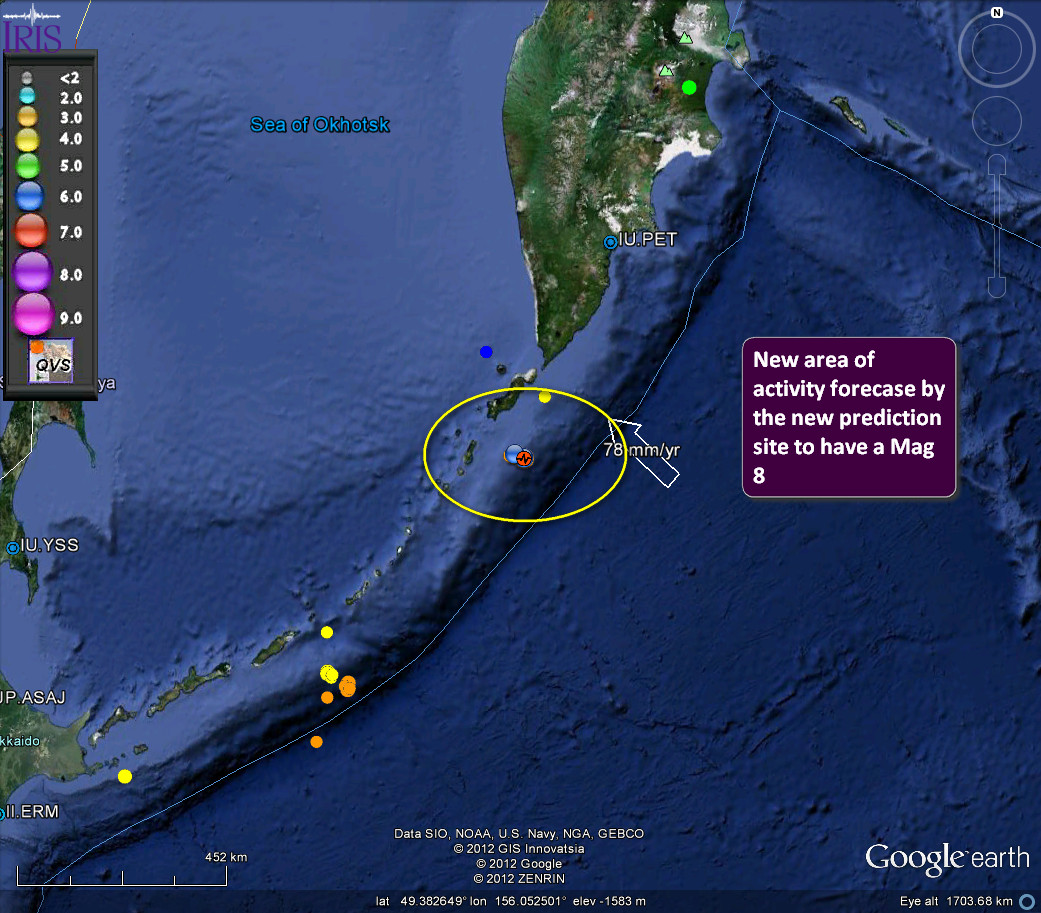
Their area

Slightly off but close enough I think to be considered valid.
Tongariro volcano (NZ) alert at new high. Normally Tongariro experiences two earthquakes of magnitude 2.5 or less per year. Since July 13th there has
been more than 20 earthquakes.
Tongariro last erupted on June 10. 1886. Approximately 1 and 2 cubic km of basaltic lava erupted from its fissure, destroying its pre-existing dome complex over a length of 8km and extended a further 9km to the SW. The eruption sadly destroyed the famous pink and white terraces, at Rotomahana. The eruption also killed about 120 people and spread ash over an area of over 10000 square kilometers.
Tongariro last erupted on June 10. 1886. Approximately 1 and 2 cubic km of basaltic lava erupted from its fissure, destroying its pre-existing dome complex over a length of 8km and extended a further 9km to the SW. The eruption sadly destroyed the famous pink and white terraces, at Rotomahana. The eruption also killed about 120 people and spread ash over an area of over 10000 square kilometers.
A "sudden rise" in volcanic activity at Mt Tongariro has prompted scientists to lift its volcanic alert status for the first time.
Source
Currently Tongariro is at Alert Level 1: Departure from typical background surface activity. Signs of volcano unrest.
Aviation Alert Level Yellow: Volcano is experiencing signs of elevated unrest above known background levels. Or, after a change from higher level: Volcanic activity has decreased significantly but continues to be closely monitored for possible renewed increase.
Geonet
edit on 20-7-2012 by DonaldD because: (no reason given)
new topics
-
)DEFINITELY STAY AWAY FROM THESE ALCOHOLIC BEVERAGES..
US Political Madness: 4 minutes ago -
Jean Michel and Brian May Live from Bratislava
General Chit Chat: 55 minutes ago -
Iranian Lawmaker Declares Iran Has Nuclear Weapons
Mainstream News: 2 hours ago -
Biden Withholding Sensitive US Intelligence on Hamas Leaders From Israel
US Political Madness: 4 hours ago -
Anybody else go to the movie theater a lot? Have you noticed how dead they are?
General Chit Chat: 5 hours ago -
Trump Record Breaking Campaign Rally 5/11 in New Jersey Draws 100,000 People
2024 Elections: 5 hours ago -
something falls in Canada
Aliens and UFOs: 5 hours ago -
US mistakes in assessing the military potential of China and Russia
ATS Skunk Works: 8 hours ago
top topics
-
Trump Record Breaking Campaign Rally 5/11 in New Jersey Draws 100,000 People
2024 Elections: 5 hours ago, 12 flags -
A new Why Files How CRISPR and AI Destroy the World
Science & Technology: 16 hours ago, 10 flags -
Biden Withholding Sensitive US Intelligence on Hamas Leaders From Israel
US Political Madness: 4 hours ago, 8 flags -
Ask AI Is A Hot Mess
Links & Other Resources: 16 hours ago, 6 flags -
Anybody else go to the movie theater a lot? Have you noticed how dead they are?
General Chit Chat: 5 hours ago, 4 flags -
Slow moving ufo over Mexico volcano Popocatepetl 8 May 2024
Aliens and UFOs: 15 hours ago, 4 flags -
something falls in Canada
Aliens and UFOs: 5 hours ago, 3 flags -
US mistakes in assessing the military potential of China and Russia
ATS Skunk Works: 8 hours ago, 3 flags -
Iranian Lawmaker Declares Iran Has Nuclear Weapons
Mainstream News: 2 hours ago, 1 flags -
Jean Michel and Brian May Live from Bratislava
General Chit Chat: 55 minutes ago, 1 flags
active topics
-
Trump Record Breaking Campaign Rally 5/11 in New Jersey Draws 100,000 People
2024 Elections • 53 • : FlyersFan -
)DEFINITELY STAY AWAY FROM THESE ALCOHOLIC BEVERAGES..
US Political Madness • 0 • : NEWTUMS -
Tschugger
Movies • 2 • : NEWTUMS -
Battle of the Bay 2024 ; Tampa, Florida Special Forces Demonstration
Military Projects • 1 • : NEWTUMS -
Iranian Lawmaker Declares Iran Has Nuclear Weapons
Mainstream News • 11 • : Dalamax -
Is Taco Bell Satanic?
Education and Media • 41 • : NEWTUMS -
Barron Trump has prior commitments?
Politicians & People • 104 • : NEWTUMS -
Ask AI Is A Hot Mess
Links & Other Resources • 15 • : NEWTUMS -
A new Why Files How CRISPR and AI Destroy the World
Science & Technology • 11 • : NEWTUMS -
Bibi’s Dilemma
Middle East Issues • 234 • : AliceTheSmall