It looks like you're using an Ad Blocker.
Please white-list or disable AboveTopSecret.com in your ad-blocking tool.
Thank you.
Some features of ATS will be disabled while you continue to use an ad-blocker.

What's Up In Western Montana? Yellowstone Connection?
page: 1share:
Some may think this a stretch....but you guys know how I like to look at the 'big picture'. I know that pretty much anywhere near the Rockies,
earthquakes should not be a surprise. I realize that. BUT....over the past few days I have been watching these odd little quakes in and around
Missoula Montana grow in frequency and now size. I have family in missoula so have always paid a little more attention and I can't ever remember
seeing this many on the map at once and a quake over 3.0 mag is not a common occurance. Looking at the current USGS map you can clearly see a
line/clusters leading North from Yellowstone/Idaho/Wyoming up through western montana and even into Canada.
There has been a recent/slight up-tick in micro quakes in the park too and I simply do NOT belive in coincidences. Take a look at the current list of quakes for the area:
sourcee
The current map as of now:
(credit USGS)
The 3.5 quake today in Western Montana:
I don't have any big, mind-blowing theories over this. It is simply an observation and a thought that maybe there is something bigger, connected going on here?
What say you?????
There has been a recent/slight up-tick in micro quakes in the park too and I simply do NOT belive in coincidences. Take a look at the current list of quakes for the area:
MAP 3.5 2011/12/14 16:56:22 46.614 -113.556 12.2 22 km ( 13 mi) SE of Clinton, MT
MAP 1.3 2011/12/13 20:22:14 47.723 -114.213 6.9 2 km ( 1 mi) WNW of Jette, MT
MAP 1.8 2011/12/13 15:06:58 44.236 -110.794 0.6 44 km ( 27 mi) ENE of Warm River, ID
MAP 2.2 2011/12/13 03:44:50 46.538 -113.282 13.5 18 km ( 11 mi) SW of Drummond, MT
MAP 1.0 2011/12/13 03:23:24 44.791 -111.525 10.1 36 km ( 22 mi) NNW of Island Park, ID
MAP 2.2 2011/12/12 13:25:01 47.764 -113.742 6.4 25 km ( 15 mi) E of Finley Point, MT
MAP 2.6 2011/12/12 06:59:46 45.137 -113.934 13.6 5 km ( 3 mi) SSW of Salmon, ID
MAP 2.3 2011/12/12 01:01:59 46.616 -113.548 9.3 22 km ( 14 mi) SE of Clinton, MT
MAP 1.5 2011/12/11 02:54:51 45.619 -111.455 6.4 18 km ( 11 mi) SW of Amsterdam-Churchill, MT
MAP 1.0 2011/12/10 06:49:29 44.089 -110.284 5.9 68 km ( 42 mi) ENE of Alta, WY
MAP 1.0 2011/12/09 05:17:34 45.442 -112.578 4.3 22 km ( 14 mi) WSW of Twin Bridges, MT
MAP 1.2 2011/12/08 17:09:52 44.490 -110.583 4.6 46 km ( 28 mi) ESE of West Yellowstone, MT
MAP 1.1 2011/12/08 15:43:28 44.486 -110.566 1.1 47 km ( 29 mi) ESE of West Yellowstone, MT
MAP 1.0 2011/12/08 14:07:50 44.502 -110.581 2.4 45 km ( 28 mi) ESE of West Yellowstone, MT
MAP 1.3 2011/12/08 13:16:17 44.501 -110.575 2.5 46 km ( 28 mi) ESE of West Yellowstone, MT
MAP 1.2 2011/12/08 13:13:31 45.334 -112.555 9.8 15 km ( 9 mi) NNE of Dillon, MT
MAP 1.2 2011/12/08 12:21:41 44.500 -110.578 2.4 46 km ( 28 mi) ESE of West Yellowstone, MT
MAP 1.3 2011/12/08 12:13:57 44.497 -110.582 2.3 45 km ( 28 mi) ESE of West Yellowstone, MT
MAP 1.4 2011/12/08 12:06:54 44.502 -110.573 2.0 46 km ( 28 mi) ESE of West Yellowstone, MT
MAP 1.3 2011/12/08 11:41:03 44.492 -110.578 2.1 46 km ( 29 mi) ESE of West Yellowstone, MT
MAP 1.4 2011/12/08 11:40:31 44.496 -110.582 2.2 45 km ( 28 mi) ESE of West Yellowstone, MT
MAP 1.6 2011/12/08 11:39:40 44.495 -110.580 2.2 46 km ( 28 mi) ESE of West Yellowstone, MT
MAP 1.3 2011/12/08 11:37:38 44.496 -110.581 1.7 46 km ( 28 mi) ESE of West Yellowstone, MT
MAP 1.1 2011/12/08 10:16:16 44.967 -112.028 21.4 37 km ( 23 mi) S of Virginia City, MT
MAP 1.0 2011/12/08 09:16:39 47.647 -113.203 14.0 57 km ( 35 mi) NNE of Seeley Lake, MT
MAP 1.5 2011/12/08 06:00:41 44.430 -110.503 17.8 54 km ( 34 mi) ESE of West Yellowstone, MT
MAP 1.6 2011/12/08 05:58:12 44.502 -110.569 2.4 46 km ( 29 mi) ESE of West Yellowstone, MT
MAP 1.2 2011/12/08 05:57:13 44.503 -110.571 2.3 46 km ( 29 mi) ESE of West Yellowstone, MT
MAP 1.4 2011/12/08 05:44:50 45.040 -110.393 13.7 25 km ( 16 mi) E of Gardiner, MT
MAP 2.5 2011/12/08 05:40:33 45.043 -110.384 16.5 26 km ( 16 mi) E of Gardiner, MT
MAP 2.5 2011/12/07 22:05:46 49.310 -113.345 0.8 58 km ( 36 mi) SW of Lethbridge, Canada
MAP 2.8 2011/12/07 20:55:05 43.649 -108.267 1.7 4 km ( 3 mi) W of Thermopolis, WY
sourcee
The current map as of now:
(credit USGS)
The 3.5 quake today in Western Montana:
Magnitude 3.5
Date-Time Wednesday, December 14, 2011 at 16:56:22 UTC
Wednesday, December 14, 2011 at 09:56:22 AM at epicenter
Time of Earthquake in other Time Zones
Location 46.614°N, 113.556°W
Depth 12.2 km (7.6 miles)
Region WESTERN MONTANA
Distances 22 km (14 miles) SE (146°) from Clinton, MT
32 km (20 miles) W (259°) from Drummond, MT
37 km (23 miles) NNW (328°) from Philipsburg, MT
314 km (195 miles) ESE (111°) from Spokane, WA
665 km (413 miles) N (349°) from Salt Lake City, UT
Location Uncertainty horizontal +/- 0.4 km (0.2 miles); depth +/- 0.4 km (0.2 miles)
Parameters NST= 51, Nph= 51, Dmin=21.4 km, Rmss=0.16 sec, Gp= 29°,
M-type=duration magnitude (Md), Version=2
Source Earthquake Studies Office, Montana Bureau of Mines and Geology
Event ID mb11088411
I don't have any big, mind-blowing theories over this. It is simply an observation and a thought that maybe there is something bigger, connected going on here?
What say you?????
edit on 14-12-2011 by westcoast because: (no reason given)
reply to post by westcoast
I have been watching for a long time and i completely agree with you. people who keep saying it is the same and nothing changing are just plain wrong.
I have been watching for a long time and i completely agree with you. people who keep saying it is the same and nothing changing are just plain wrong.
Man an eruption would be awful. I really don't want to be inundated with volcanic ash
Interesting, I remember hearing about the 3.0 in Missoula, MT but never did any investigations on my part. I live in the Billings area and if any
thing happens here I'll report it
I hope everone is stocked up on essentials....
Maybe there is a direct connection with these quakes and Yellowstone, and maybe not, but with the recent quakes in Oklahoma and elsewhere, I'm not taking any chances.
....always be prepared....for anything.
Maybe there is a direct connection with these quakes and Yellowstone, and maybe not, but with the recent quakes in Oklahoma and elsewhere, I'm not taking any chances.
....always be prepared....for anything.
reply to post by Char-Lee
I think part of this is how you ask the question, and how/where you get your answer. Puterman has showed this with some of the amazing graphs he's put together over the past year.
You can look at the amount of energy released (worldwide) vs. other years, you can look at the individual number of quakes worldwide and in certain areas. While the energy released and the number of quakes may not be on a substantial up-swing, that does not mean there may not be increased activity in certain areas. This is where some people get confused or perhaps are not clear on the differences. I can say that while more energy was obviously released in Japan this year vs last year, that doesn't mean more energy for the whole world was released. make sense???
I have NOT done any searches for the area in question in thist post, to make any comparisons. I should have some time tonight to do this, unless someone else wants to. Then again, we could look at the energy released, but we also need to look at locations and trends. What faults/areas are involved. Western Montana is also FULL of hotsprings.
I'm pretty worried myself, as I'm only 250 m south of the park. The quakes in montana and utah both make lines to yellowstone which i find
intimidating. Although officals keep saying its normal activity, still unnerving !
reply to post by leawyoming
I think it would take a WHOLE lot to make them say anything different. The implications are just way too big.
I think it would take a WHOLE lot to make them say anything different. The implications are just way too big.
reply to post by westcoast
im in western montana (north west) and i didnt feel anything or see anything on the news localy here but im kinda desensitized to eq's(was 4 in the 89 eq in the loma quake) but i will look into this as anything with yellostone makes me nervious
im in western montana (north west) and i didnt feel anything or see anything on the news localy here but im kinda desensitized to eq's(was 4 in the 89 eq in the loma quake) but i will look into this as anything with yellostone makes me nervious
well we wont hear anything until its to big to hide, I heard the president has a gag order on info concerning yellowstone, could be b.s. but its
hard to believe it could blow without warning its to massive
Originally posted by isyeye
I hope everone is stocked up on essentials....
Maybe there is a direct connection with these quakes and Yellowstone, and maybe not, but with the recent quakes in Oklahoma and elsewhere, I'm not taking any chances.
....always be prepared....for anything.
A friend a nurse in Oregon said last week, FEMA came and fitted them all with N100 face masks for particles. it concerned her that they each were fitted for the masks. These are for disease as well as industrial particles.
reply to post by Char-Lee
If that was done by a medical regulatory agency, that wouldn't be of much concern, but that it was FEMA throws up a big red flag for me.
If that was done by a medical regulatory agency, that wouldn't be of much concern, but that it was FEMA throws up a big red flag for me.
Anyone have any idea what the ash fallout patterns would look like?
Didn't they just start drilling near Yellowstone?......Not saying this is the cause, but hey ya' never know. We may not be causing the quakes persay
but I think we do nudge them along with what we do to this earth.
Originally posted by leawyoming
reply to post by Char-Lee
now I'm scared ........ that freaks me out a bit
Her family sent for respirators for home and suggested we do the same. Can't hurt they store for 5 years.
Swarms in Western Montana and Yellowstone are quite common but you never know! I too live in the Billings area and if it does go off I won't have
long to worry about anything anymore. End of game!
Definitly going to buy some respirators but seems weird as i wouldnt think oregon would be affected by the ash given the wind blows north east in
that area but im not a weather girl, and who knows how big the eruption would be
reply to post by Char-Lee
It is the same, nothing is changing. Actually it is changing. The magnitudes are getting lower over the years. The trend is downwards. There was a big bunching in 1994.
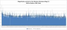
Basically nothing is up in Western Montana it is down
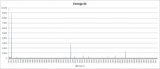
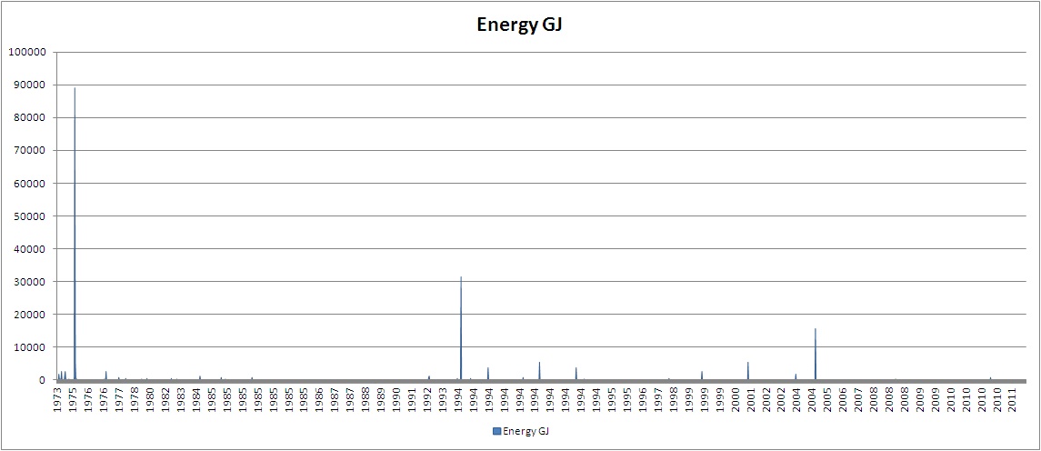
In terms of energy released more was going on between 1994 and 2004. Maybe quieter is not so good though!
It is the same, nothing is changing. Actually it is changing. The magnitudes are getting lower over the years. The trend is downwards. There was a big bunching in 1994.
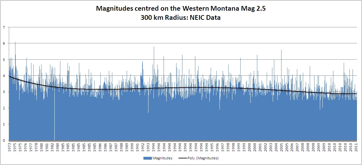
Basically nothing is up in Western Montana it is down
In terms of energy released more was going on between 1994 and 2004. Maybe quieter is not so good though!
edit on 14/12/2011 by PuterMan because: (no reason given)
reply to post by leawyoming
You can rest assured that is BS. There is no way that could happen. Way too many people watching it.
I heard the president has a gag order on info concerning yellowstone, could be b.s. but its hard to believe it could blow without warning its to massive
You can rest assured that is BS. There is no way that could happen. Way too many people watching it.
new topics
-
BIDEN Admin Begins Planning For January 2025 Transition to a New President - Today is 4.26.2024.
2024 Elections: 3 hours ago -
Big Storms
Fragile Earth: 5 hours ago -
Where should Trump hold his next rally
2024 Elections: 8 hours ago -
Shocking Number of Voters are Open to Committing Election Fraud
US Political Madness: 8 hours ago -
Gov Kristi Noem Shot and Killed "Less Than Worthless Dog" and a 'Smelly Goat
2024 Elections: 9 hours ago -
Falkville Robot-Man
Aliens and UFOs: 9 hours ago -
James O’Keefe: I have evidence that exposes the CIA, and it’s on camera.
Whistle Blowers and Leaked Documents: 10 hours ago -
Australian PM says the quiet part out loud - "free speech is a threat to democratic dicourse"...?!
New World Order: 11 hours ago -
Ireland VS Globalists
Social Issues and Civil Unrest: 11 hours ago
top topics
-
James O’Keefe: I have evidence that exposes the CIA, and it’s on camera.
Whistle Blowers and Leaked Documents: 10 hours ago, 17 flags -
Australian PM says the quiet part out loud - "free speech is a threat to democratic dicourse"...?!
New World Order: 11 hours ago, 15 flags -
Blast from the past: ATS Review Podcast, 2006: With All Three Amigos
Member PODcasts: 14 hours ago, 13 flags -
Biden "Happy To Debate Trump"
2024 Elections: 12 hours ago, 13 flags -
Ireland VS Globalists
Social Issues and Civil Unrest: 11 hours ago, 10 flags -
Mike Pinder The Moody Blues R.I.P.
Music: 14 hours ago, 8 flags -
BIDEN Admin Begins Planning For January 2025 Transition to a New President - Today is 4.26.2024.
2024 Elections: 3 hours ago, 7 flags -
What is the white pill?
Philosophy and Metaphysics: 14 hours ago, 6 flags -
Shocking Number of Voters are Open to Committing Election Fraud
US Political Madness: 8 hours ago, 6 flags -
Big Storms
Fragile Earth: 5 hours ago, 6 flags
active topics
-
-@TH3WH17ERABB17- -Q- ---TIME TO SHOW THE WORLD--- -Part- --44--
Dissecting Disinformation • 704 • : 777Vader -
University of Texas Instantly Shuts Down Anti Israel Protests
Education and Media • 316 • : Schmoe3755 -
Gov Kristi Noem Shot and Killed "Less Than Worthless Dog" and a 'Smelly Goat
2024 Elections • 63 • : GENERAL EYES -
Mood Music Part VI
Music • 3113 • : MRTrismegistus -
BIDEN Admin Begins Planning For January 2025 Transition to a New President - Today is 4.26.2024.
2024 Elections • 20 • : BustedBoomer -
One Flame Throwing Robot Dog for Christmas Please!
Weaponry • 12 • : worldstarcountry -
RAAF airbase in Roswell, New Mexico is on fire
Aliens and UFOs • 13 • : Ophiuchus1 -
President BIDEN's FBI Raided Donald Trump's Florida Home for OBAMA-NORTH KOREA Documents.
Political Conspiracies • 40 • : BingoMcGoof -
Australian PM says the quiet part out loud - "free speech is a threat to democratic dicourse"...?!
New World Order • 7 • : 19Bones79 -
It takes One to Be; Two to Tango; Three to Create.
Philosophy and Metaphysics • 8 • : Compendium