It looks like you're using an Ad Blocker.
Please white-list or disable AboveTopSecret.com in your ad-blocking tool.
Thank you.
Some features of ATS will be disabled while you continue to use an ad-blocker.

Official Story Shill Crushed By Truther/Researcher in Radio Debate!
page: 48share:
This is a post in response to my own thoughts in this post of me :
www.abovetopsecret.com...
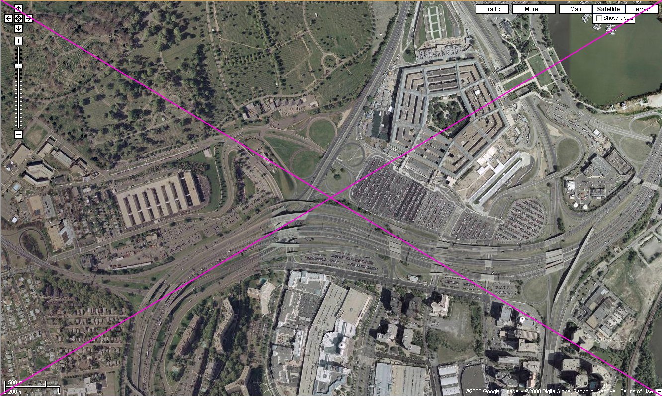
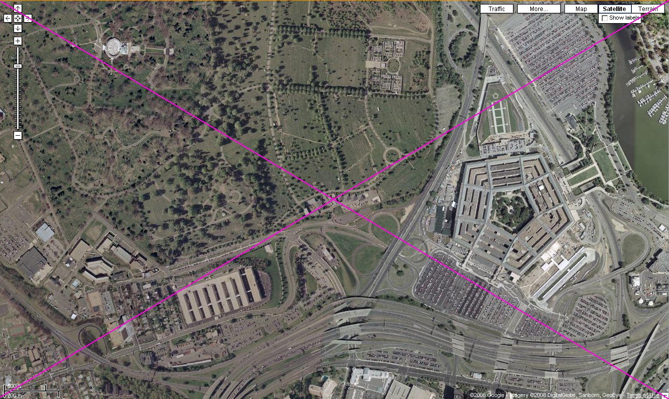
The below links is investigative research, by "JFK" from the Loose Change board, who plotted all the USAF 84 RADES radar returns for the last minutes of Flight 77 on a big Google Earth map of the south of Pentagon area and posted this when that board was down, on the www.911oz.com bulletin board.
One thing is not clear at all to me, however. Where did he get those two last radar returns from, the numbers 21 and 22 on his map and in his list? And why did he color them pink, and let the rest uncolored?
Why do I ask this? Because Reheat once told us this on 27 May 2009 :
Note what Caustic Logic told us in November 2007 in a thread titled ""FDR expert Dennis Cimino? "" :
www.abovetopsecret.com...
The below links is investigative research, by "JFK" from the Loose Change board, who plotted all the USAF 84 RADES radar returns for the last minutes of Flight 77 on a big Google Earth map of the south of Pentagon area and posted this when that board was down, on the www.911oz.com bulletin board.
One thing is not clear at all to me, however. Where did he get those two last radar returns from, the numbers 21 and 22 on his map and in his list? And why did he color them pink, and let the rest uncolored?
Why do I ask this? Because Reheat once told us this on 27 May 2009 :
You have MADE NO POINT and you have not supported the assertion that the FAA radar data supports the animation used in another thread.
(LT insert : i]The "NORAD" anim or the NTSB animation? Showing a NoC flight path for Flight AA77. )
The last radar return from AA 77 on it's approach to the Pentagon was from DCA and the return was approximately abeam the Sheraton Hotel on it's known flight path toward the Pentagon. That return supports the FDR RO2 (readout) in terms of position. There are NO OTHER RADAR RETURNS from AA 77 to support the animation.
Note what Caustic Logic told us in November 2007 in a thread titled ""FDR expert Dennis Cimino? "" :
Pilots for 911 Truth say the last second of FDR data - 9:37:44 - does not fit the damage of impact - its pitch isn't right, its wing bank, and especially its altitude. This is true. However one point they missed is the last second also has the wrong coordinates - a point about six seconds prior to impact, well over a mile back, where that altitude fits and pitch and bank are irrelevant, having plenty of time to change and fit the impact pattern.
Findings of John Farmer - PDF link
(LT insert : The total website of John Farmer is defunct. This was his PDF link-text : 911files.info/rades/911files_workbooks/NTSB_RADES Comparative Analysis.pdf )
I've seen no good reason this much would be missing due to the crash. One poster here mentioned a crash where the black box stopped I think 20 sec early, but turns out the tail section with FDR fell off before impact - I'd guess about 20 sec earlier.
Radar return signals posts and threads by "JFK" :
Title : ""Things that make ya go hmmm - 84 RADES data""
www.911oz.com...
He also posted it three times on the Loose Change board :
Title 1 : ""84 RADES data and speed of flight 77""
s1.zetaboards.com...
Title 2 : ""Things that make ya go hmmm.; 84 RADES data at the WTC.""
s1.zetaboards.com...
Title 3 : ""Moved:plausible NoC flightpath? ""
s1.zetaboards.com...
This last one has 10 pages, and has the most valuable information in it in regards to "JFK" his radar returns research. And links to the PfT forum posters, who gave a wealth of additional radar aspects data.
This is a PfT thread in response of the Title 2 thread :
Title 4 : Strange Transponder Data, Difference Between Flight 11 and 175
pilotsfor911truth.org...
* (Post #4 by Balsamo : his years long banning tendencies explained by himself)
* (Post #6 by dMz explains the primary, secondary and 'reinforced' USAF radar targets) :
This is also a thread of interest at PfT for the 84 RADES subject coverage :
Title 5 : Primary Vs. Secondary Radar?
pilotsfor911truth.org...
This whole 10 posts page is of very HIGH interest for those having doubts about the hijacks, especially post #8 by JackD is a MUST read.
The ""radar multipath echoes from an actual target which can cause ghosts to appear below ground or very high up"" - post #6 by dMz has been used to try to explain that very strange radar return position number 22, but that is not a viable explanation, since it was registered 10.920 seconds later, after nearly another full 360° radar dish revolution.
But not the 12 seconds it would have taken for a full dish revolution !
So, is this an extra radar return inserted from another radar dish somewhere else than DCA (Washington National Airport's ground radar).
These kinds of radar return "ghosts" will show on radar screens, when a sharp conversion layer between a cold and a warm layer of air will cause the reflected radar beam to reflect back from this conversion layer. Or from the ground or water.
Title : ""Things that make ya go hmmm - 84 RADES data""
www.911oz.com...
He also posted it three times on the Loose Change board :
Title 1 : ""84 RADES data and speed of flight 77""
s1.zetaboards.com...
Title 2 : ""Things that make ya go hmmm.; 84 RADES data at the WTC.""
s1.zetaboards.com...
Title 3 : ""Moved:plausible NoC flightpath? ""
s1.zetaboards.com...
This last one has 10 pages, and has the most valuable information in it in regards to "JFK" his radar returns research. And links to the PfT forum posters, who gave a wealth of additional radar aspects data.
This is a PfT thread in response of the Title 2 thread :
Title 4 : Strange Transponder Data, Difference Between Flight 11 and 175
pilotsfor911truth.org...
* (Post #4 by Balsamo : his years long banning tendencies explained by himself)
* (Post #6 by dMz explains the primary, secondary and 'reinforced' USAF radar targets) :
"A 'primary' only target is received as a reflection of radar energy only. A 'secondary' or 'beacon' only target is recorded as a response of the aircraft's transponder to interrogation by the [primary] radar system. A 'reinforced' target is recorded by the radar system in lieu of a primary or secondary target when transponder information is coincident with and reinforces a reflection of radar energy. Generally, secondary and reinforced targets are referred to as "secondary" targets." [ www.ntsb.gov... ]
This is also a thread of interest at PfT for the 84 RADES subject coverage :
Title 5 : Primary Vs. Secondary Radar?
pilotsfor911truth.org...
This whole 10 posts page is of very HIGH interest for those having doubts about the hijacks, especially post #8 by JackD is a MUST read.
The ""radar multipath echoes from an actual target which can cause ghosts to appear below ground or very high up"" - post #6 by dMz has been used to try to explain that very strange radar return position number 22, but that is not a viable explanation, since it was registered 10.920 seconds later, after nearly another full 360° radar dish revolution.
But not the 12 seconds it would have taken for a full dish revolution !
So, is this an extra radar return inserted from another radar dish somewhere else than DCA (Washington National Airport's ground radar).
These kinds of radar return "ghosts" will show on radar screens, when a sharp conversion layer between a cold and a warm layer of air will cause the reflected radar beam to reflect back from this conversion layer. Or from the ground or water.
Excerpts from "JFK" his Australian board posts :
Two identical 2 MB plots for 77's spiraling down to the Pentagon follow below.
The last two radar returns are respectively 2 x 12 secs (return 21) and 3 x 12 secs (return 22) away from the number 20 radar return.
Which means there is one 12 secs radar return missing (20a), as explained by Reheat and others as blocked by the higher buildings in Crystal City, when the plane was already lower than the upper floors from these buildings.
The riverside radar dish (DCA) at Washington International made 1 revolution per circa 12 seconds :
img501.imageshack.us...
i27.tinypic.com...
(Use CTRL-plus-"+" (EU is Strg-plus-"+" ), to enlarge, about 7 times.)
I saved an imageshack-copy a few years ago at my ATS Media account :
You need this online aircraft turn, bank and accelerated-stall calculator to check if the spiral was within viable 757 flight path attitude:
www.csgnetwork.com...
The last known NTSB speed was 378.964 MPH at radar return point 20, that was roughly 2 miles from the impact and witnesses said it was accelerating after that point.
The spiraling down with a diameter of about 4.3 miles and a radius of about 2.15 miles was easily within the plane's viable turn radius possibilities, at a right bank of about 28°.
Note worthy is, that the linked to online bank and turn calculator calculates for a level turn, not for a spiraling down turn.
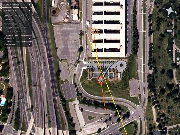
Last-but-one 84 RADES (?) position of AA77, the number 21 spot on the Google Earth map :
img374.imageshack.us...
Last 84 RADES (?) position of AA77, the number 22 spot on the Google Earth map :
img368.imageshack.us...
I have several questions regarding this research from "JFK" at Loose Change :
1. What could be the reason for the two PLA 77 appearances at position 17 and 18 in this list, while all other radar return positions were stamped PLA 0 ? :
Was the transponder back on for about minimum 24 seconds, 2 radar dish revolutions; or maximum 48 seconds, 4 dish revolutions?
His full AA77 spiral radar return position list :

2. How can a last radar return number 22 (SoC) have been registered in the 84 RADES radar returns for all 9/11 flights report, that was 11.92 seconds later registered than the radar return number 21 (NoC), and this radar return number 22 was only 410 meters south, and only slightly further, 210 meters EAST, than the Lat/Lon position of the number 21 (NoC) radar return registration? That last radar return position registration, number 22, should have been registered about 12 seconds later than number 21 if that plane was still flying, and thus far over the Potomac River, in the Washington DC area, about minimum 6000 feet (1829 meters) further than the number 21 (NoC) radar return.
See my question 1, and these two positions 21 and 22 on two Google Earth maps made by "JFK", and his Lat/Lon check on the positioning-method he used, resulting in an exact match with the Washington Monument, which proved his method very reliable and precise :
Pos. 21 and 22 in "JFK" 84 RADES list :

(Pos. 22, SoC) img368.imageshack.us...
(Pos. 21, NoC)
(Wash.Monument, Lat/Lon method Check)

3. Can we pinpoint a Lat/Lon position for the last ACARS uplinked and last confirmed back, position of Flight 77 ?
4. Can we construct, in the same manner as JFK has demonstrated very well in his posts I linked to, another calculated fllight path for Flight 77, but now solely based on the confirmed-back ACARS (evt. engine) messages their Lat/Lon data ?
What is the fault/error margin for Lat/Lon positions from these confirmed ACARS messages?
Can we use the GPS Visualizer method mentioned by "Sergio" from PfT in his Post #149 ?
5. Can we construct Flight 77's Lat/Lon positions from the ACARS messages, each 11 to 12 minutes confirmed and returned back to all the now known ARINC ground stations in its 360° reach?
Based on trigonometric calculations from all Signal Strength Values (SSV), downlinked from the plane and thus send back to all these different RGS stations from the PDF we have now in possession ?
Every receiving ARINC station had a different signal strength value attached to the confirmed/downlinked Lat/Lon ACARS messages.
Just as your handphone's position can be calculated by your provider, if ordered by the Law, it should be easy to do that, if we knew f.ex. that signal strength 1000 is for the plane right above/on top of the station, and signal strength 0 meaning that the plane is out of range.
I think that VHF disturbance influences will make this very difficult, but, who knows?
Two identical 2 MB plots for 77's spiraling down to the Pentagon follow below.
The last two radar returns are respectively 2 x 12 secs (return 21) and 3 x 12 secs (return 22) away from the number 20 radar return.
Which means there is one 12 secs radar return missing (20a), as explained by Reheat and others as blocked by the higher buildings in Crystal City, when the plane was already lower than the upper floors from these buildings.
The riverside radar dish (DCA) at Washington International made 1 revolution per circa 12 seconds :
img501.imageshack.us...
i27.tinypic.com...
(Use CTRL-plus-"+" (EU is Strg-plus-"+" ), to enlarge, about 7 times.)
I saved an imageshack-copy a few years ago at my ATS Media account :
You need this online aircraft turn, bank and accelerated-stall calculator to check if the spiral was within viable 757 flight path attitude:
www.csgnetwork.com...
The last known NTSB speed was 378.964 MPH at radar return point 20, that was roughly 2 miles from the impact and witnesses said it was accelerating after that point.
The spiraling down with a diameter of about 4.3 miles and a radius of about 2.15 miles was easily within the plane's viable turn radius possibilities, at a right bank of about 28°.
Note worthy is, that the linked to online bank and turn calculator calculates for a level turn, not for a spiraling down turn.
Last-but-one 84 RADES (?) position of AA77, the number 21 spot on the Google Earth map :
img374.imageshack.us...
Last 84 RADES (?) position of AA77, the number 22 spot on the Google Earth map :
img368.imageshack.us...
I have several questions regarding this research from "JFK" at Loose Change :
1. What could be the reason for the two PLA 77 appearances at position 17 and 18 in this list, while all other radar return positions were stamped PLA 0 ? :
Was the transponder back on for about minimum 24 seconds, 2 radar dish revolutions; or maximum 48 seconds, 4 dish revolutions?
His full AA77 spiral radar return position list :
2. How can a last radar return number 22 (SoC) have been registered in the 84 RADES radar returns for all 9/11 flights report, that was 11.92 seconds later registered than the radar return number 21 (NoC), and this radar return number 22 was only 410 meters south, and only slightly further, 210 meters EAST, than the Lat/Lon position of the number 21 (NoC) radar return registration? That last radar return position registration, number 22, should have been registered about 12 seconds later than number 21 if that plane was still flying, and thus far over the Potomac River, in the Washington DC area, about minimum 6000 feet (1829 meters) further than the number 21 (NoC) radar return.
See my question 1, and these two positions 21 and 22 on two Google Earth maps made by "JFK", and his Lat/Lon check on the positioning-method he used, resulting in an exact match with the Washington Monument, which proved his method very reliable and precise :
Pos. 21 and 22 in "JFK" 84 RADES list :
(Pos. 22, SoC) img368.imageshack.us...
(Pos. 21, NoC)
(Wash.Monument, Lat/Lon method Check)
3. Can we pinpoint a Lat/Lon position for the last ACARS uplinked and last confirmed back, position of Flight 77 ?
4. Can we construct, in the same manner as JFK has demonstrated very well in his posts I linked to, another calculated fllight path for Flight 77, but now solely based on the confirmed-back ACARS (evt. engine) messages their Lat/Lon data ?
What is the fault/error margin for Lat/Lon positions from these confirmed ACARS messages?
Can we use the GPS Visualizer method mentioned by "Sergio" from PfT in his Post #149 ?
5. Can we construct Flight 77's Lat/Lon positions from the ACARS messages, each 11 to 12 minutes confirmed and returned back to all the now known ARINC ground stations in its 360° reach?
Based on trigonometric calculations from all Signal Strength Values (SSV), downlinked from the plane and thus send back to all these different RGS stations from the PDF we have now in possession ?
Every receiving ARINC station had a different signal strength value attached to the confirmed/downlinked Lat/Lon ACARS messages.
Just as your handphone's position can be calculated by your provider, if ordered by the Law, it should be easy to do that, if we knew f.ex. that signal strength 1000 is for the plane right above/on top of the station, and signal strength 0 meaning that the plane is out of range.
I think that VHF disturbance influences will make this very difficult, but, who knows?
Roosevelt Roberts described the C-130 (GOPHER06) he saw two to three minutes later than the incoming attack plane that was flying low and appeared to
him as seemingly just above the light poles along Lane One of the Southern Parking Lot.
I take these times from my quote here :
He said it could be also a commercial airliner.
Well, look at this photograph from that "commercial airliner" (the C-130) and decide for yourself if you could have identified that quite high turning plane as a C-130 or a commercial airliner :
And this is a photo from just a few seconds before the C-130 came out from under that mushroom cloud, but now it includes the ground structures :
In my opinion, he described the C-130 as also coming towards the east, to Washington DC.
He stood in a southern position compared to the whole Pentagon complex.
In the eastern dock part of South Loading. Which is adjacent to the South Parking Lot.
And Lane One is the Lane which lays along the most western side of that Lot.
This is a closeup video-view made by Mr Looney of the C-130 that appears from out of the smoke cloud :
Title : 9-11 "Mystery Plane" Closeup :
www.youtube.com...
As you can see, it is not that easy for a lay person in avionics, to identify that plane with their bare eyes.
A C-130 however has 4 turbofan engines, a Boeing 757-200 has only 2 jet engines.
And the C-130 has straight wings, while the 757 has V-shaped wings that are not positioned in the middle part of the plane.
I take these times from my quote here :
the FAA Pinnacle PDF last data entry for GOPHER06 on page 2 from the FAA communications (page 6/6 in the Pinnacle PDF), when the C-130 was instructed to make a 60° right turn to the northwest.
We will find a FAA Pinnacle PDF clocked UTC time of 13:40:40 (09:40:40 ET) for instructing this turn, from heading 270° to 330°.
He said it could be also a commercial airliner.
Well, look at this photograph from that "commercial airliner" (the C-130) and decide for yourself if you could have identified that quite high turning plane as a C-130 or a commercial airliner :
And this is a photo from just a few seconds before the C-130 came out from under that mushroom cloud, but now it includes the ground structures :
In my opinion, he described the C-130 as also coming towards the east, to Washington DC.
He stood in a southern position compared to the whole Pentagon complex.
In the eastern dock part of South Loading. Which is adjacent to the South Parking Lot.
And Lane One is the Lane which lays along the most western side of that Lot.
This is a closeup video-view made by Mr Looney of the C-130 that appears from out of the smoke cloud :
Title : 9-11 "Mystery Plane" Closeup :
www.youtube.com...
As you can see, it is not that easy for a lay person in avionics, to identify that plane with their bare eyes.
A C-130 however has 4 turbofan engines, a Boeing 757-200 has only 2 jet engines.
And the C-130 has straight wings, while the 757 has V-shaped wings that are not positioned in the middle part of the plane.
A post by JFK at page 1, in his 10 page thread :
Note the "left wing down" statement ! Which is totally in contrast with the right wing down attitude described by many others. But this witness had probably the best view at the plane of all witnesses !!!
Only Sean Boger had about the same view, only from the opposite side !!! He described a right wing up attitude.
That's also a left wing down attitude !!! Just as Albert Hemphill said.
And that's not a right wing bank......
Question is, did BOTH man describe the wing as if they were in the cockpit, like most aviators do ???
Of course the reporter made a mistake, Route 110 must be Route 27 !!
Route 110 runs along the riverside facade of the Pentagon, at the "back", east side.
In the same post is this somewhat confusingly positioned couple explaining what the husband saw :
Do I understand this man right? Did he come UP westwards on I-395, from National Airport?
Or had he already turned off I-395 and driving on the part of it named Route 27 (Washington Boulevard) to bring his wife back towards the Pentagon?
How does his "coming straight down the road at us " statement fit in then? And his "just as we got even with the Pentagon" statement? And his "it crossed about 100 feet (30 meters) in front of us" statement? And he looked out to the front....
Do note that this man states that the plane headed STRAIGHT for its target.
No intent to turn or to maneuver in any way.
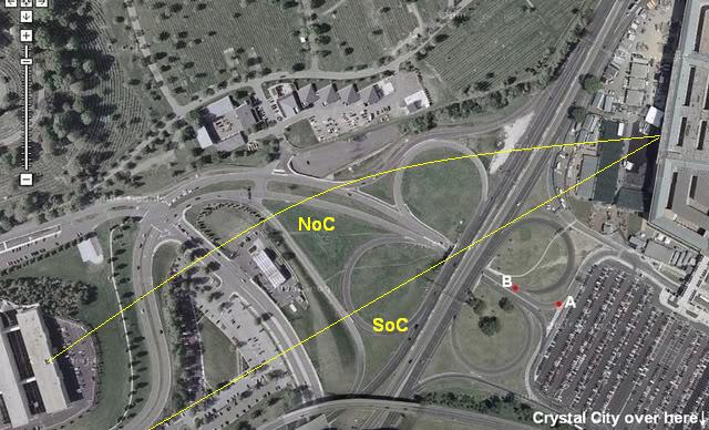
This can be evidence of the last 150 meters of a SoC or NoC flight path, since that did cross straight over Route 27 and straight into the west wall. But he says that he saw what he estimated to be about the last SEVEN seconds of the flight.
That must be from a point beside the Sheraton Hotel....
Do note also that he does not utter one word about 5 downed light poles, right in front of him....
If he was on Route 27 and was 100 feet in front of a SoC crossing plane, he MUST have seen the plane clipping the 5 light poles. But he does not mention that at all, which would be an event while witnessing, to never forget.
So, he seems to have witnessed a NoC crossing plane just before impact.
EDIT :
Same post, Phillip Thompson : "" It was flying only a couple of hundred feet off the ground — I could see the passenger windows glide by. The plane looked as if it were coming in for a landing — cruising at a shallow angle, wings level, very steady. But, strangely, the landing gear was up and the flaps weren’t down. ""
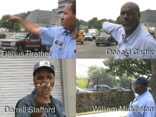
EDIT2 : At last found the four ANC workers CIT-animated gifs, with Mr Stafford holding that toy plane in his right hand, in a 20° bank angle. With its LEFT wing UP, seen from inside its cockpit !!! That's a right bank?
Albert Hemphill, a BMDO (Ballistic Missile Defense Organization) staff member watched from the Navy Annex:
""As I stood there, I instinctively ducked at the extremely loud roar and whine of a jet engine spooling up. Immediately, the large silver cylinder of an aircraft appeared in my window, coming over my right shoulder as I faced the Westside of the Pentagon directly towards the heliport. The aircraft, looking to be either a 757 or Airbus, seemed to come directly over the annex, as if it had been following Columbia Pike - an Arlington road leading to Pentagon.
The aircraft was moving fast, at what I could only estimate as between 250 to 300 knots.
All in all, I probably only had the aircraft in my field of view for approximately 3 seconds.
The aircraft was at a sharp downward angle of attack, on a direct course for the Pentagon. It was "clean", in as much as, there were no flaps applied and no apparent landing gear deployed. He was slightly left wing down as he appeared in my line of sight, as if he'd just "jinked" to avoid something. As he crossed Route 110 he appeared to level his wings, making a slight right wing slow adjustment as he impacted low on the Westside of the building to the right of the helo, tower and fire vehicle around corridor 5.""
..Email posted to www.ournetfamily.com/WarOnTerror webmaster
Copy of message / Sept 12 4:20 PM
Note the "left wing down" statement ! Which is totally in contrast with the right wing down attitude described by many others. But this witness had probably the best view at the plane of all witnesses !!!
Only Sean Boger had about the same view, only from the opposite side !!! He described a right wing up attitude.
""As he was coming towards me it just seemed like he was tilting the aircraft to his right.
That's also a left wing down attitude !!! Just as Albert Hemphill said.
And that's not a right wing bank......
Question is, did BOTH man describe the wing as if they were in the cockpit, like most aviators do ???
Of course the reporter made a mistake, Route 110 must be Route 27 !!
Route 110 runs along the riverside facade of the Pentagon, at the "back", east side.
In the same post is this somewhat confusingly positioned couple explaining what the husband saw :
Ret. Army Col. Mitch Mitchell, CBS military consultant, was bringing his wife back from National Airport on Interstate 395 towards the Pentagon:
""Just as we got even with the Pentagon, I looked out to the front and saw, coming straight down the road at us, a huge jet plane clearly with American Airlines written on it, and it looked like it was coming in to hit us. I told my wife, 'It's going to hit the Pentagon.' It crossed about 100 feet in front of us and at about 20 feet altitude and we watched it go in. It struck the Pentagon, and there was no indication whatever that it was doing anything other than performing a direct attack on that building. The landing gear was up. There were no flaps down and it looked like a deadly missile on the final phase of its mission into the building.""
""We saw what I estimate to be about the last seven seconds of the flight. It was a straight-in flight, angled slightly down , and there was--there was no intent to turn or to maneuver in any way. It was headed straight for its target and we were helpless to do anything about it but watch.""
CBS The Early Show, 9/13/01 - Transcript (Lexis Nexis)
(text mirror) www2.hawaii.edu...
Do I understand this man right? Did he come UP westwards on I-395, from National Airport?
Or had he already turned off I-395 and driving on the part of it named Route 27 (Washington Boulevard) to bring his wife back towards the Pentagon?
How does his "coming straight down the road at us " statement fit in then? And his "just as we got even with the Pentagon" statement? And his "it crossed about 100 feet (30 meters) in front of us" statement? And he looked out to the front....
Do note that this man states that the plane headed STRAIGHT for its target.
No intent to turn or to maneuver in any way.
This can be evidence of the last 150 meters of a SoC or NoC flight path, since that did cross straight over Route 27 and straight into the west wall. But he says that he saw what he estimated to be about the last SEVEN seconds of the flight.
That must be from a point beside the Sheraton Hotel....
Do note also that he does not utter one word about 5 downed light poles, right in front of him....
If he was on Route 27 and was 100 feet in front of a SoC crossing plane, he MUST have seen the plane clipping the 5 light poles. But he does not mention that at all, which would be an event while witnessing, to never forget.
So, he seems to have witnessed a NoC crossing plane just before impact.
EDIT :
Same post, Phillip Thompson : "" It was flying only a couple of hundred feet off the ground — I could see the passenger windows glide by. The plane looked as if it were coming in for a landing — cruising at a shallow angle, wings level, very steady. But, strangely, the landing gear was up and the flaps weren’t down. ""
EDIT2 : At last found the four ANC workers CIT-animated gifs, with Mr Stafford holding that toy plane in his right hand, in a 20° bank angle. With its LEFT wing UP, seen from inside its cockpit !!! That's a right bank?
edit on 25/12/11 by LaBTop because: Added Phillip Thompson.
edit on 25/12/11 by LaBTop because: Added ANC workers animated
gifs made by CIT.
edit on 25/12/11 by LaBTop because: Corrected Sean Bogers account.
edit on 25/12/11 by LaBTop
because: Added Mr Staffords left wing up comment.
edit on 25/12/11 by LaBTop because: (no reason given)
I have to establish a common nominator at this moment.
Is a right bank flown flight path, when a plane is flying with its left wing up and its right wing down, when we look from behind the plane, over its tail, towards the cockpit?
In other words, if we were the pilot sitting in his cockpit, its left wing would be up and its right wing would be down? That's when he flies in a right bank? Probably turning?
I think so, but we must be sure.
edit on 25/12/11 by LaBTop because: mixed up right with left again......
This is the by a firm named STK constructed; ordered by the FAA in conjunction with NORAD; animation of the flight path flown by AA77. Added by the
NTSB to a FOIA request directed at the NTSB.
It describes a diagonally flown path over the Annex roofs, a north of CITGO flown RIGHT bank with its RIGHT wing down and not as both Hemphill and Boger say, with its LEFT wing down.
And an impact.
www.youtube.com...
This post describes quite some banking back and forth.
This post by "gunplumber" at the LooseChangeForums explains yaw, roll, rudder and slip interactions :
This is the last post #243 in that 10 pages long LooseChangeForum thread, a post by "onesliceshort", a member at LooseChangeForum and also at PfT.
I think he is also a member at ATS, under another alias.
It describes all the witnesses I also used in my one allowed 7 pages long thread at PfT, in exactly the same manner. He adds a few explanatory drawings on top of his texts.
We both seem to follow the exact same logical rhetoric, to conclude that all these witnesses were NoC witnesses.
That's why I am a bit puzzled why there is such a vitriolic response by these PfT members, when I introduce the same logic, and go all the way further to conclude to also an impact, based on all the OTHER witnesses they never ad.
s1.zetaboards.com...
I like to excerpt his Levi Stephens witness account, since I never saw that before, that he was interviewed by CIT. I would like we get a link to that CIT interview. So all of you can check his words out.
Levi had a perfect side-view at the plane, and its positions during its descend path towards the west wall impact. All the way in to the impact.
It describes a diagonally flown path over the Annex roofs, a north of CITGO flown RIGHT bank with its RIGHT wing down and not as both Hemphill and Boger say, with its LEFT wing down.
And an impact.
www.youtube.com...
This post describes quite some banking back and forth.
This post by "gunplumber" at the LooseChangeForums explains yaw, roll, rudder and slip interactions :
All conventional aircraft will naturally yaw in the opposite direction of a roll if no rudder input is given. The effect is called Adverse Yaw. To counter this, the appropriate amount of rudder input must be given in the same direction of a roll in order to accomplish a clean, efficient turn. This is known as a Coordinated Turn.
Naturally occurring adverse yaw as well as excessive opposite yaw that is input by the pilot during a roll simply causes the aircraft to go into a rather inefficient sideslip. It does not cause a loss of control.
gunplumber
This is the last post #243 in that 10 pages long LooseChangeForum thread, a post by "onesliceshort", a member at LooseChangeForum and also at PfT.
I think he is also a member at ATS, under another alias.
It describes all the witnesses I also used in my one allowed 7 pages long thread at PfT, in exactly the same manner. He adds a few explanatory drawings on top of his texts.
We both seem to follow the exact same logical rhetoric, to conclude that all these witnesses were NoC witnesses.
That's why I am a bit puzzled why there is such a vitriolic response by these PfT members, when I introduce the same logic, and go all the way further to conclude to also an impact, based on all the OTHER witnesses they never ad.
s1.zetaboards.com...
I like to excerpt his Levi Stephens witness account, since I never saw that before, that he was interviewed by CIT. I would like we get a link to that CIT interview. So all of you can check his words out.
Levi Stephens:
Interviewed and confirmed by CIT.
I saw this [plane] come flying over the Navy Annex.
CIT interviewed him personally.
He said repeatedly that it was on the "right" of the station or that it would be on his "left" if he was at the station facing the Pentagon.
He further confirmed by saying that it was on the "Arlington Cemetery" side of the gas station.
Surely he would have mentioned the plane coming straight at him as you have demonstrated?
Look how close he was to the lightpoles and didn´t mention the plane anywhere NEAR this area.

Levi had a perfect side-view at the plane, and its positions during its descend path towards the west wall impact. All the way in to the impact.
I try again, and make myself clearer.
I am looking for ( see my earlier two viable proposals on my two maps with that huge white area and the center point of the arc) a long, slow and smooth, nearly constant right bank descend with just one correction to level the plane off, near Route 27, to pass over that one as low as reported by f.ex. Steve Riskus, but already in near level flight then, to slam into the west wall, after crossing over that road.
I showed a photo of what Riskus has seen, and has agreed with in email.
And definitely not an S-shaped maneuver, like Reheat proposed in his sig.
That would mean a slight correction to bring it into level position, like a slight left roll-up.
I.o.w., a slight right wing tilting up, which right wing was all the time before in a slight down attitude, while executing that long SLIGHT right bank.
The way all witnesses in their cars on Route 27 saw it coming towards them.
That would fit all these Route 27 NoC witnesses descriptions (I described their statements of the plane's attitude in my linked-to 9 pages long thread at PfT, in my O.P.) of what they saw as the attitude of the attack plane.
Which attack plane I am sure now, was the original Flight AA77 that departed at Dulles from gate D26.
Its FDR data from that Dulles departure, now corrected for the accumulated positional drift effects over at least one week; and the Dulles rampers and AA flight attendants reports by the FBI, do corroborate my firm belief.
It would not fit however, the speeds recorded in the end of that same FDR, which were 2.5 times as fast, 378 to over 400 MPH, end speed just in front of the west wall some 540 MPH. If it flew so fast in reality, why are there so many witnesses who describe a much slower flying plane?
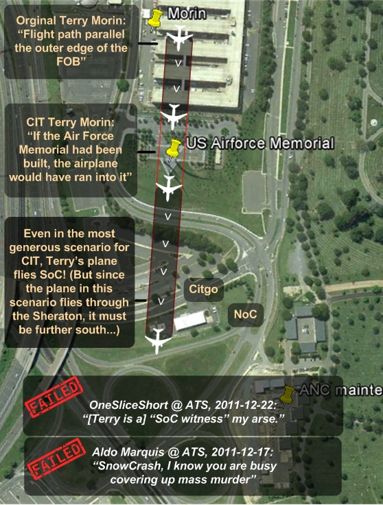
Terry Morin must have ran first 3 meter out and then at least 5 meter further on to the parking lot, to be able to still see the tail dip behind those Northeastern placed row of trees inbetween the Annex wing 8 and the CITGO station. If the plane would have flown with nearly 800 km per hour as the FDR data depict, he would not have been able to see the plane at all anymore. That distance is too small, from Annex wing 5 up to the tall trees line at the bottom of Columbia Pike.
Btw, that speed in that dense air, would cause severe vibrations in the air frame and especially the thinner wing and tail ends.
The plane would cover 222 meters in one second, if it flew 800 km/hr.!
Two times the width of the Pentagon lawn, from wall to road.
It flies those speeds NORMALLY in far much thinner air, at 8 to 11 km heights.
Sean Boger, a NAVY Helipad Tower operator with long enough aviation experience, also described a much slower flying plane, descending towards his tower windows, near the Pentagon's west wall. He estimated about 10 to 12 seconds from the moment he saw the plane above the 8th Annex-wing its roof antenna, till it slammed to the left of him, into the Pentagon's west wall.
But he describes a Left wing down attitude.....that's a left bank, but not necessarily a turn also. A left bank can be in straight flight too.
I know now, that the plane must have flown near landing speeds to fulfill all the descriptions of ALL the witnesses, while we allow just slight alterations of their remarks, otherwise they don't fit in the possible flightpath and observed ATTITUDE of the plane by ALL anymore.
I was trying to find a speed to feed the online calculator with, at which the bank angle is so small, that it would not trigger the aw-effect I know now, that would have occurred, when flown with a 22.9° or more, bank angle.
The one I found after many tries, with a turn diameter of 3.3 miles (which means a turn radius of 2.7 kilometer, as shown in my earlier post and in my viable arc), has a bank angle of 22° and an initial speed of 200 KTS (230.200 MPH) at its known stall speed of 160 KTS (184.160 MPH).
That 22° bank angle is for the observing lay-men, while in full panic, a near level flight.
In my OP I showed a photo of what Sean Boger would have seen, that's about this bank angle.
There's a G-Load of 1.1 Gs then, and an Increased Stall Speed of 166 KTS (191 MPH). That's pretty near the rated stall speed of 160 KTS, but still possible I think.
But we must not forget that the plane was in a descending attitude, thus a slight acceleration must have naturally occurred, which will compensate for the danger of near accelerated stall effects.
The 90° Turn Time is 40.9 seconds, and the turn I drew is about 1/4th of a 90° turn.
That's about 10 seconds to cover that distance. Which corroborates Morin's and Boger's statements.
PS: your proposal in your signature-link, still is a sharp IMPOSSIBLE to fly, S-shaped maneuver.
I think it is clear from my two proposals, that mine is a long slightly right wing down one.
Ending in level flight over Route 27.
I am looking for ( see my earlier two viable proposals on my two maps with that huge white area and the center point of the arc) a long, slow and smooth, nearly constant right bank descend with just one correction to level the plane off, near Route 27, to pass over that one as low as reported by f.ex. Steve Riskus, but already in near level flight then, to slam into the west wall, after crossing over that road.
I showed a photo of what Riskus has seen, and has agreed with in email.
And definitely not an S-shaped maneuver, like Reheat proposed in his sig.
That would mean a slight correction to bring it into level position, like a slight left roll-up.
I.o.w., a slight right wing tilting up, which right wing was all the time before in a slight down attitude, while executing that long SLIGHT right bank.
The way all witnesses in their cars on Route 27 saw it coming towards them.
That would fit all these Route 27 NoC witnesses descriptions (I described their statements of the plane's attitude in my linked-to 9 pages long thread at PfT, in my O.P.) of what they saw as the attitude of the attack plane.
Which attack plane I am sure now, was the original Flight AA77 that departed at Dulles from gate D26.
Its FDR data from that Dulles departure, now corrected for the accumulated positional drift effects over at least one week; and the Dulles rampers and AA flight attendants reports by the FBI, do corroborate my firm belief.
It would not fit however, the speeds recorded in the end of that same FDR, which were 2.5 times as fast, 378 to over 400 MPH, end speed just in front of the west wall some 540 MPH. If it flew so fast in reality, why are there so many witnesses who describe a much slower flying plane?
Terry Morin must have ran first 3 meter out and then at least 5 meter further on to the parking lot, to be able to still see the tail dip behind those Northeastern placed row of trees inbetween the Annex wing 8 and the CITGO station. If the plane would have flown with nearly 800 km per hour as the FDR data depict, he would not have been able to see the plane at all anymore. That distance is too small, from Annex wing 5 up to the tall trees line at the bottom of Columbia Pike.
Btw, that speed in that dense air, would cause severe vibrations in the air frame and especially the thinner wing and tail ends.
The plane would cover 222 meters in one second, if it flew 800 km/hr.!
Two times the width of the Pentagon lawn, from wall to road.
It flies those speeds NORMALLY in far much thinner air, at 8 to 11 km heights.
Sean Boger, a NAVY Helipad Tower operator with long enough aviation experience, also described a much slower flying plane, descending towards his tower windows, near the Pentagon's west wall. He estimated about 10 to 12 seconds from the moment he saw the plane above the 8th Annex-wing its roof antenna, till it slammed to the left of him, into the Pentagon's west wall.
But he describes a Left wing down attitude.....that's a left bank, but not necessarily a turn also. A left bank can be in straight flight too.
I know now, that the plane must have flown near landing speeds to fulfill all the descriptions of ALL the witnesses, while we allow just slight alterations of their remarks, otherwise they don't fit in the possible flightpath and observed ATTITUDE of the plane by ALL anymore.
I was trying to find a speed to feed the online calculator with, at which the bank angle is so small, that it would not trigger the aw-effect I know now, that would have occurred, when flown with a 22.9° or more, bank angle.
The one I found after many tries, with a turn diameter of 3.3 miles (which means a turn radius of 2.7 kilometer, as shown in my earlier post and in my viable arc), has a bank angle of 22° and an initial speed of 200 KTS (230.200 MPH) at its known stall speed of 160 KTS (184.160 MPH).
That 22° bank angle is for the observing lay-men, while in full panic, a near level flight.
In my OP I showed a photo of what Sean Boger would have seen, that's about this bank angle.
There's a G-Load of 1.1 Gs then, and an Increased Stall Speed of 166 KTS (191 MPH). That's pretty near the rated stall speed of 160 KTS, but still possible I think.
But we must not forget that the plane was in a descending attitude, thus a slight acceleration must have naturally occurred, which will compensate for the danger of near accelerated stall effects.
The 90° Turn Time is 40.9 seconds, and the turn I drew is about 1/4th of a 90° turn.
That's about 10 seconds to cover that distance. Which corroborates Morin's and Boger's statements.
PS: your proposal in your signature-link, still is a sharp IMPOSSIBLE to fly, S-shaped maneuver.
I think it is clear from my two proposals, that mine is a long slightly right wing down one.
Ending in level flight over Route 27.
I have now two important witnesses, both with aviation experience (Hemphill USMC aviator, Boger Helipad tower controller), who do NOT fit the long
right banking turn towards the Pentagon west wall impact point.
They both explained to have witnessed a left wing down flight attitude from the attack plane.
They both had excellent views of the plane, Hemphill in the top floor of the Annex 8th wing, looking at the plane's back end from Annex to impact, with its left wing down.
And Boger in the two stories high Helipad control Tower watching the plane coming towards him, descending from over the Annex building wing 8 center, in a path leading north of the CITGO building, but in a left wing down attitude, and turning back towards an impact.
Anybody can explain that mutually exclusive dilemma to me?
Can a plane fly a long descending right turn, while its LEFT wing is down?
That's in my experience, a left banking turn and not a right banking turn.
It could have never reached the impact zone, if it was all the way in a left wing down attitude.
But the plane impacted, thus logic tells us that both men were mixing up their lefts and rights, or described a very short occurrence of that left wing down attitude.
Any disagreement?
Originally posted by djeminy
Originally posted by snowcrash911
Even if AA 77 was allowed to fly through the Sheraton.. it would be SoC... Merry Christmas!edit on 23-12-2011 by snowcrash911 because: (no reason given)
Think that you're shooting yourself in the foot with that weird flight path, snowcrash.
I suggest you try another one, just to avoid you becoming as (in)famous as poor 'broken sticks'!
At least it's good to see that you finally agree that the lamp poles must have been staged -
Cheers and merry christmas
Beat me to it djeminy.
He's posted the same self debunking nonsense at 911forums.
He was also over the moon when "Achimspok" (who openly went back on this same ridiculous "North of Columbia Pike path" at P4T because it would have required up to 72º of bank - link available) posted this gif:
img686.imageshack.us...
...yet claimed that Stutt's data was "reliable".
There were NO left banks recorded on Stutt's "data". Why do these guys keep contradicting themselves?
www.abovetopsecret.com...
Wetblanky has you guys pegged. Clowns falling out of a VW Beetle.

Read my post in my Watergate thread first, then my next words.
Is it possible that Hemphill and Boger describe a left wing down flight attitude correctly, because the plane had to make first a SLIGHT left bank from its position above the 8th wing Annex roof, towards the 100 feet north and 100 feet above the CITGO station roof where Lagasse saw it pass? And then made that right wing down correction again to return to the 10 yards right of the Helipad position (with its left wing tip).
Note that the difference between a SoC position and the 100 feet NoC position is very small, about 100 to 150 meters/yards.
Would the plane just had to "jinx" (roll) very fast from left to right in 1 second, without executing such huge bank angles as expected by our aviators onboard, to cover that 100 to 150 meters/yards? A quick roll from left to right?
That would explain Hemphill's and Boger's left wing down remarks, but also the four ANC workers descriptions of a plane coming towards them and then right-banking away from the ANC grounds, back to the Helipad direction again.
Originally posted by ThePostExaminer
Originally posted by djeminy
Originally posted by snowcrash911
Even if AA 77 was allowed to fly through the Sheraton.. it would be SoC... Merry Christmas!edit on 23-12-2011 by snowcrash911 because: (no reason given)
Think that you're shooting yourself in the foot with that weird flight path, snowcrash.
I suggest you try another one, just to avoid you becoming as (in)famous as poor 'broken sticks'!
At least it's good to see that you finally agree that the lamp poles must have been staged -
Cheers and merry christmas
Beat me to it djeminy.
He's posted the same self debunking nonsense at 911forums.
He was also over the moon when "Achimspok" (who openly went back on this same ridiculous "North of Columbia Pike path" at P4T because it would have required up to 72º of bank - link available) posted this gif:
img686.imageshack.us...
...yet claimed that Stutt's data was "reliable".
There were NO left banks recorded on Stutt's "data". Why do these guys keep contradicting themselves?
www.abovetopsecret.com...
Wetblanky has you guys pegged. Clowns falling out of a VW Beetle.
Oh yeah, before I forget, Snowcrash. Exactly who proposed that flightpath? Me? Morin?
Here's what he described based on his own testimony:

That yellow line drawn by me is the real flight path that Morin could see, after he moved out of the Wing 4 and 5 Annex buildings, towards the parking lot fence along the Pike.
And it passes exactly to the north of the small northern parking along the north side of the CITGO, exactly where Pentagon Police sergeant William Lagasse placed it in all his interviews (about 100 feet to the north of him, where he was filling up his police car's tank at the most northwestern pump, the first most northern pump).
From inside and in between those Annex 4 and 5 Wings, where he originally saw the plane fly over his head, while standing 3 meters (10 feet) inside them, he could never have been able to see that plane flying through the spot where the years later erected Air Force monument now stands.
Thus, he must have constructed that first part of the plane's flight path over the Annex Wings 5,6,7 and 8 roofs, from where he picked up sight again at that plane, when he ran to the fence, and then back to where it before, flew over his head.
He picked up sight again on the plane quite fast i.m.o., since the plane flew still high enough to become in his line of view over the southern rims of those Annex-Wing buildings. And the 8th Annex-Wing was at least 3 meters lower than the other 7 Wings.
Again, I remind everyone of Morin's remark about the row of trees at the bottom of the "hill" behind the 8th Wing.
He said they were situated ""to the Northeast"" of the Annex. He did not say to the East or even Southeast, no, he deliberately said ""to the Northeast"", which is in a direction to the north of the CITGO canopy.
If he would have seen the plane on the officially sponsored 60.25° true north path, to the south of that part of the Pike along the Annex, he would have indicated those trees as to the East.
I reread my above post about OneSliceShort's last post in that 10 page long thread :
s1.zetaboards.com...
I'm sure now, that he mixed up Levi's words with Sean Boger's remarks in a telephone interview with CIT.
Those are exactly the words from Sean, and not from Levi.
Sean stood in the second floor of the Helipad tower, when he saw the plane come at him from over the Annex roofs, then to the right of the CITGO (north side) and then turning slightly to pass the Helipad concrete landing pad on his left, to slam into the west wall, just 60 meters beside and left of him.
I can not remember CIT interviewing Levi anytime.
EDIT : They did however : www.thepentacon.com...
And strangely enough, they both used the same descriptions to explain the flight path.
They both persist that the plane impacted.
s1.zetaboards.com...
Levi Stephens:
Interviewed and confirmed by CIT.
"" I saw this [plane] come flying over the Navy Annex.""
CIT interviewed him personally.
He said repeatedly that it was on the "right" of the station or that it would be on his "left" if he was at the station facing the Pentagon.
He further confirmed by saying that it was on the "Arlington Cemetery" side of the gas station.
Surely he would have mentioned the plane coming straight at him as you have demonstrated?
Look how close he was to the lightpoles and didn't mention the plane anywhere NEAR this area.
I'm sure now, that he mixed up Levi's words with Sean Boger's remarks in a telephone interview with CIT.
Those are exactly the words from Sean, and not from Levi.
Sean stood in the second floor of the Helipad tower, when he saw the plane come at him from over the Annex roofs, then to the right of the CITGO (north side) and then turning slightly to pass the Helipad concrete landing pad on his left, to slam into the west wall, just 60 meters beside and left of him.
I can not remember CIT interviewing Levi anytime.
EDIT : They did however : www.thepentacon.com...
And strangely enough, they both used the same descriptions to explain the flight path.
They both persist that the plane impacted.
edit on 27/12/11 by LaBTop because: CIT did interview Levi by phone, see link.
The difference between NoC and SoC is one or two very small or light pilot inputs.
I have overdone myself again (smile), the arc must be more shallow, with a bigger radius.
But you get the idea, I hope.
This NoC flight path was about the same as the SoC path, both a smooth descend.
And in the NoC path, there's no obstacle at all.
How on earth these PfT people can cling on to their MUST OVERFLY nonsense, is beyond me.
If you imagine you could topple over the whole photo, so that you could look from a point on the ground in the bottom center of the above photo, towards both flight paths, you would see a steady descending slow downwards slope of both yellow lines towards their impact point.
And as I demonstrated in my latests posts, even at a speed of 400 MPH there would be no stall speed danger, no excessive G-loads, the NoC turn and arc would be perfectly possible and the plane would clear all obstacles free, and then impact at the second floor slab.
I don't know. Is there any way to make this easier to follow? I feel like we are being 'spammed' with info, and after awhile the brain just starts
to check out and loose interest in what's being said. I see pages and pages of diagrams and people talking past each other, claims made and counter
claims etc.
Perhaps a syllogistic form of argument used to properly identify and highlight, what it is one is arguing for, and a break down from there?
Perhaps a syllogistic form of argument used to properly identify and highlight, what it is one is arguing for, and a break down from there?
reply to post by LaBTop
All well and good and fascinating from a purely theoretical point of view, but in the real world, utterly useless.
By "useless" I refer, of course, to all the machinations and head-scratching you personally went through in order to arrive at this "NoC" conclusion. And, I say "fascinating" because of the sheer levels of effort that have been expended into it.
The ancient Greek fable and myth of Sisyphus comes to mind, actually, in regards to the futility of it all.
In essence, we have the notoriously unreliable and inaccurate "eyewitness" accounts (just a few out of many others) that have been 'pounced' upon in order to cast 'doubt' on something that otherwise is solidly factual based on substantial amounts of hard, demonstrable evidence to the contrary.
So, a futile waste of time.
Originally posted by LaBTop
The difference between NoC and SoC is one or two very small or light pilot inputs.
I have overdone myself again (smile), the arc must be more shallow, with a bigger radius.
But you get the idea, I hope.
You should not be making derogatory statements about anyone else after this display of cluelessness! It is difficult to choose the most idiotic statement you've made, there are so many.. This one would be somewhere in the top ten...
You are simply emulating CIT by drawing lines and arcs on a map without regard to whether or not they can be flown.. To comply with CIT's chosen witnesses you need to start with Paik and then Morin. You should be able to determine from my signature file it can't be done, but you keep hoping and searching for magic that does not exist. There is no magic airspeed and there is no magic pilot technique to make it happen.
All you have are some interviews by unqualified morons of witnesses who misjudged distances and relationships of objects during a traumatic flash of time. That's why trained investigators conduct interviews of witnesses following accidents, not morons with a preconceived agenda.
All of this nonsense would last no more than 10-15 minutes in a Courtroom with testimony from an expert witness. It would simply be dismissed as frivolous delusions bearing no relationship to reality just as occurred in the April Gallop case. As it is, it is only Poppycock on Conspiracy Forums on the Internet and that all it will ever be in another 10 or even 10,000 years....
GEOMETRY POP QUIZ FOR ALDO MARQUIS AND "ONESLICESHORT"

- Terry Morin
Source: http://web.archive.org/web/20011122065302/http://www.coping.org/911/survivor/pentagon.htm
For predictable SPAM responses committing the Nirvana fallacy, please see here.
Please answer either (A) or (B). Do not dodge or deflect. Answer directly, without woolly, self-aggrandizing, diversionary rhetoric and without the usual wall of flyover marketing lies. Take your time.
The aircraft was essentially right over the top of me and the outer portion of the FOB (flight path parallel the outer edge of the FOB).
- Terry Morin
Source: http://web.archive.org/web/20011122065302/http://www.coping.org/911/survivor/pentagon.htm
For predictable SPAM responses committing the Nirvana fallacy, please see here.
Please answer either (A) or (B). Do not dodge or deflect. Answer directly, without woolly, self-aggrandizing, diversionary rhetoric and without the usual wall of flyover marketing lies. Take your time.
edit on 27-12-2011 by snowcrash911 because: (no reason given)
new topics
-
New Whistleblower: "I worked on a team that dealt with with NHI technology and left in 2018."
Aliens and UFOs: 1 hours ago -
According to Wiki, HAMAS is the same as "Palestinians"
US Political Madness: 1 hours ago -
Two Guards Shot Dead And Gang Boss Nicknamed "The Fly" On The Run.
Mainstream News: 2 hours ago -
Long Range Drone - Test Flight
General Chit Chat: 2 hours ago -
Fake Aurora's produced by HAARP
Science & Technology: 3 hours ago -
15.6 Percent of US Population Now Foreign Born - 51.6 Million
Social Issues and Civil Unrest: 3 hours ago -
Deadbots - AI Deepfakes that Simulate Dead People Risks Haunting Relatives
Science & Technology: 3 hours ago
top topics
-
How much did Doctors get bribed
Diseases and Pandemics: 14 hours ago, 13 flags -
According to Wiki, HAMAS is the same as "Palestinians"
US Political Madness: 1 hours ago, 5 flags -
New Whistleblower: "I worked on a team that dealt with with NHI technology and left in 2018."
Aliens and UFOs: 1 hours ago, 4 flags -
Fake Aurora's produced by HAARP
Science & Technology: 3 hours ago, 3 flags -
Long Range Drone - Test Flight
General Chit Chat: 2 hours ago, 3 flags -
Deadbots - AI Deepfakes that Simulate Dead People Risks Haunting Relatives
Science & Technology: 3 hours ago, 1 flags -
15.6 Percent of US Population Now Foreign Born - 51.6 Million
Social Issues and Civil Unrest: 3 hours ago, 1 flags -
Two Guards Shot Dead And Gang Boss Nicknamed "The Fly" On The Run.
Mainstream News: 2 hours ago, 1 flags
active topics
-
Jean Michel and Brian May Live from Bratislava
General Chit Chat • 7 • : Asktheanimals -
Israeli strikes on southern Gaza city of Rafah kill 22, mostly children, as US advances aid package
Middle East Issues • 246 • : Anyrven -
According to Wiki, HAMAS is the same as "Palestinians"
US Political Madness • 24 • : 5thHead -
Deadbots - AI Deepfakes that Simulate Dead People Risks Haunting Relatives
Science & Technology • 11 • : andy06shake -
Fake Aurora's produced by HAARP
Science & Technology • 50 • : Oldcarpy2 -
15.6 Percent of US Population Now Foreign Born - 51.6 Million
Social Issues and Civil Unrest • 32 • : CriticalStinker -
Gaza Genocide Real or Propaganda
Middle East Issues • 269 • : v1rtu0s0 -
New Whistleblower: "I worked on a team that dealt with with NHI technology and left in 2018."
Aliens and UFOs • 1 • : nugget1 -
Bibi’s Dilemma
Middle East Issues • 318 • : Anyrven -
Candidate TRUMP Now Has Crazy Judge JUAN MERCHAN After Him - The Stormy Daniels Hush-Money Case.
Political Conspiracies • 1556 • : FlyersFan