It looks like you're using an Ad Blocker.
Please white-list or disable AboveTopSecret.com in your ad-blocking tool.
Thank you.
Some features of ATS will be disabled while you continue to use an ad-blocker.

Amazing weather manipulation pics from the 26th
page: 1share:
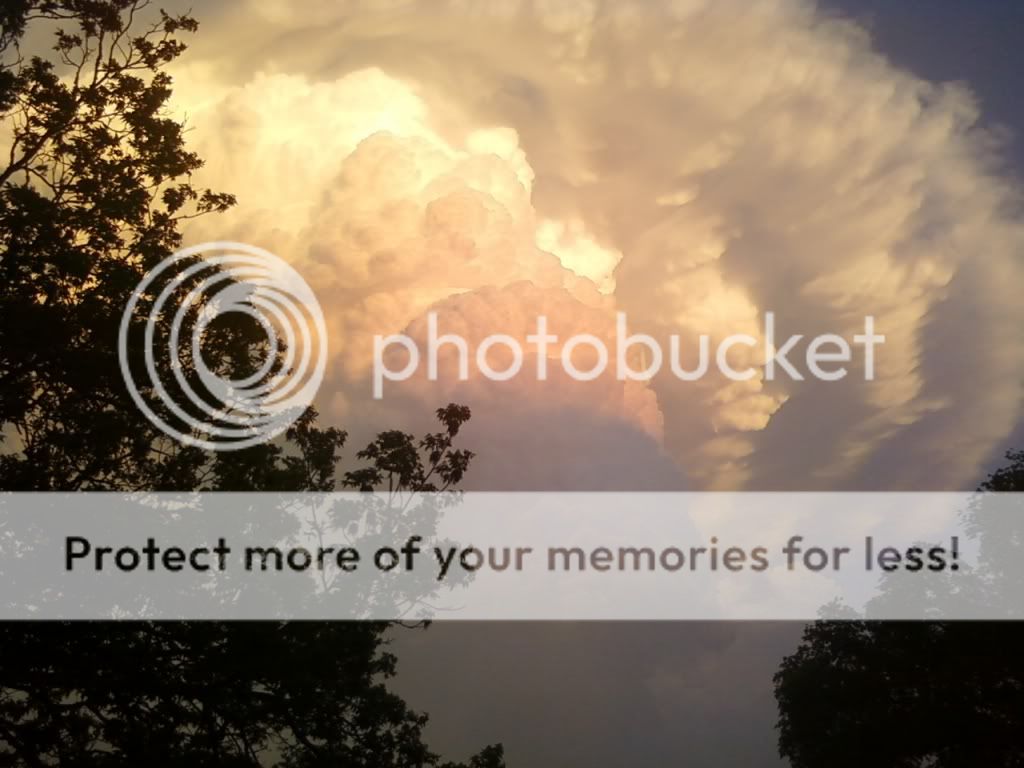
These are some pics i took on the 26th at the Austin texas air port. Its hard to tell in the pics because they are 2d and not 3d but, their are 2
masses of cloud. The first one is the thin layer at the top witch is a circle of 3 rings with one large circle in the middle of those 3 rings. The
second mass is below the rings. The second mass was expanding and morphing. It looked like their was a UFO with in the cloud (i did not see a UFO)
just spraying these clouds at up direction. The clouds looked like a mushroom cloud it was morphing and expanding just like one.
www.youtube.com...
I started to see lighning come from it when it hit night and a little latter the whole sky was fogged. I could not see down my streets. The air was covered in chemdust. I think that this cloud mass helped contribute to bring moister north of texas witch helped those tornado's.


www.youtube.com...
I started to see lighning come from it when it hit night and a little latter the whole sky was fogged. I could not see down my streets. The air was covered in chemdust. I think that this cloud mass helped contribute to bring moister north of texas witch helped those tornado's.
edit on 28-4-2011 by sabbathcrazy because: (no reason
given)
Interesting pics for sure! I want to add this article/video, NASA released a time lapse vid showing the storms from space. I noticed the big part of
the storm formed from a pinpoint location between Texas and Louisiana. Keep an eye on the lower-left side of the vid, and you'll see what I'm talking
about. Wish I could embed it, but only know how to do it from Youtube vids.
NASA Time Lapse from Space of Southern storms
S & F too!
NASA Time Lapse from Space of Southern storms
S & F too!
edit on 28-4-2011 by TheyWontBelieveU because: added Stars and Flags
reply to post by sabbathcrazy
Interesting shots.. Here's a link from an austin news channel yesterday.
LINK.......
In yours though, they seem to be coming from the ground...
Interesting shots.. Here's a link from an austin news channel yesterday.
LINK.......
In yours though, they seem to be coming from the ground...
reply to post by TheyWontBelieveU
Interesting Video and good spot on the origin point. I must ask the OP if that origin point is where you took the photos?
Since when do storm clouds originate over land? Can anyone enlighten the subject?
Interesting Video and good spot on the origin point. I must ask the OP if that origin point is where you took the photos?
Since when do storm clouds originate over land? Can anyone enlighten the subject?
edit on 4/28/2011 by forall2see because: (no reason given)
Originally posted by forall2see
reply to post by TheyWontBelieveU
Since when do storm clouds originate over land? Can anyone enlighten the subject?
Try wiki en.wikipedia.org...
edit on 28-4-2011 by Aloysius the Gaul
because: (no reason given)
Originally posted by Aloysius the Gaul
Originally posted by forall2see
reply to post by TheyWontBelieveU
Since when do storm clouds originate over land? Can anyone enlighten the subject?
Try wiki en.wikipedia.org...edit on 28-4-2011 by Aloysius the Gaul because: (no reason given)
It lasted 30min. I saw the clouds move in. Then for 30min i saw them morphing, then i saw lightning in the clouds for about 5min and then the morphing stopped.
edit on 28-4-2011 by sabbathcrazy because: (no reason given)
reply to post by sabbathcrazy
If you google or search youtube for "cumulus forming timelapse" you'll get a lot of similar examples.
It's spectacular, but not uncommon.
If you google or search youtube for "cumulus forming timelapse" you'll get a lot of similar examples.
It's spectacular, but not uncommon.
reply to post by forall2see
Of course storm clouds form over land.
Since when has someone thought they only originate over anything else?
Perhaps I'm missing your point, but really, it's called weather.
Of course storm clouds form over land.
Since when has someone thought they only originate over anything else?
Perhaps I'm missing your point, but really, it's called weather.
It's a common cumulonimbus capillatus incus cloud. With mammas apparent.
What does this mean?
It's a puffy cloud with precipitation, has reached very high into the atmosphere, has cirrus cloud feathery edges, a top that flattens out on top and there are bulges in some of the cloud.
They are not unusual, in fact they are very common. They can spawn tornadoes.
But they are just clouds, behaving as clouds always have since the first cloud developed. Nature does not need any help; I live in tornado alley and I see these clouds through most of spring, summer and fall. When I can, I chase them, hoping to see a tornado.
reply to post by stars15k
Well Ive been looking diligently for evidence of clouds forming over dry land. The only somewhat probable scenario I have found is when the air is cooled to its dew point. However when that happens the clouds form sporadically and all over the place and they do not have one single point of origin.
If you have some credible information you can share I would be happy to look at it. Most search engines are only popping up with yahoo answers and the like... and to me, those things are just opinions formed by other users.
It has always been my understanding that clouds are formed via the evaporation of moisture into the air. Correct me if I'm wrong but.... was there some incredibly deep lake at it's origin on land? Center of a HAARP ring maybe? Yeah....HAARP....I said it!
Originally posted by stars15k
It's a common cumulonimbus capillatus incus cloud. With mammas apparent.
What does this mean?
It's a puffy cloud with precipitation, has reached very high into the atmosphere, has cirrus cloud feathery edges, a top that flattens out on top and there are bulges in some of the cloud.
They are not unusual, in fact they are very common. They can spawn tornadoes.
But they are just clouds, behaving as clouds always have since the first cloud developed. Nature does not need any help; I live in tornado alley and I see these clouds through most of spring, summer and fall. When I can, I chase them, hoping to see a tornado.
Yeah man but the strange thing about it, is that its by a air port witch has radar witch can be used for weather manipulation. It had that big ring above it of clouds above it. I saw a video on the same day at the same time of Texas having a huge circular weather manipulation radar signature over it. The weather went from clear to dense fog chemdust and at the same time that was happening tornados wear forming in Alabama. All so in alabama the same weather manipulation radar signatures wear popping up that wear in Texas. If you looked at the radar that day you could see the moister from Texas feeding this supper storm. Their is no doubt this was part of weather manipulation.
Originally posted by forall2see
reply to post by stars15k
Well Ive been looking diligently for evidence of clouds forming over dry land. The only somewhat probable scenario I have found is when the air is cooled to its dew point. However when that happens the clouds form sporadically and all over the place and they do not have one single point of origin.
If you have some credible information you can share I would be happy to look at it. Most search engines are only popping up with yahoo answers and the like... and to me, those things are just opinions formed by other users.
It has always been my understanding that clouds are formed via the evaporation of moisture into the air. Correct me if I'm wrong but.... was there some incredibly deep lake at it's origin on land? Center of a HAARP ring maybe? Yeah....HAARP....I said it!
Just to add to what your saying. Their has been no rain in Texas for a while so we are dry. The day this happened i remember the winds wear coming from the west and i thought that was weird because they usely come from the south.
reply to post by sabbathcrazy
I was aware of that also since I have been keeping up to date. Good to have your personal statement on the fact as well
@ Sabbath...
You are indeed correct. I saw the same video. Dutch has been getting more and more spot on with his predictions. It's a sham I tell ya when we have people that can see these things happening clear as day and well in advance. We could be saving lives instead of losing 300 plus so far
There has to be a way to get that guy some credibility so that more people will take him seriously and more forewarning put into place. This frquency based weather manipulation has gotten way out of hand. Look at China.... admittedly using weather manipulation for the greater good. On a global scale however it's just sick to think that these people think the way that they do.
Someones on top pulling all the strings of countless puppets in a real life horror show...
I was aware of that also since I have been keeping up to date. Good to have your personal statement on the fact as well
@ Sabbath...
Yeah man but the strange thing about it, is that its by a air port witch has radar witch can be used for weather manipulation. It had that big ring above it of clouds above it. I saw a video on the same day at the same time of Texas having a huge circular weather manipulation radar signature over it. The weather went from clear to dense fog chemdust and at the same time that was happening tornados wear forming in Alabama. All so in alabama the same weather manipulation radar signatures wear popping up that wear in Texas. If you looked at the radar that day you could see the moister from Texas feeding this supper storm. Their is no doubt this was part of weather manipulation.
You are indeed correct. I saw the same video. Dutch has been getting more and more spot on with his predictions. It's a sham I tell ya when we have people that can see these things happening clear as day and well in advance. We could be saving lives instead of losing 300 plus so far
There has to be a way to get that guy some credibility so that more people will take him seriously and more forewarning put into place. This frquency based weather manipulation has gotten way out of hand. Look at China.... admittedly using weather manipulation for the greater good. On a global scale however it's just sick to think that these people think the way that they do.
Someones on top pulling all the strings of countless puppets in a real life horror show...
Originally posted by sabbathcrazy
Yeah man but the strange thing about it, is that its by a air port witch has radar witch can be used for weather manipulation.
That's a hole new theory to me - radar is used for weather manipulation??
Care to explain? A new thread might be appropriate if you think it is a different topic
The weather went from clear to dense fog chemdust
What is this "chemdust"? Have you sampled it and found out what is in it?
All so in alabama the same weather manipulation radar signatures wear popping up that wear in Texas. If you looked at the radar that day you could see the moister from Texas feeding this supper storm. Their is no doubt this was part of weather manipulation.
I see no evidence, not no doubt!!
Originally posted by sabbathcrazy
Yeah man but the strange thing about it, is that its by a air port witch has radar witch can be used for weather manipulation. It had that big ring above it of clouds above it. I saw a video on the same day at the same time of Texas having a huge circular weather manipulation radar signature over it. The weather went from clear to dense fog chemdust and at the same time that was happening tornados wear forming in Alabama. All so in alabama the same weather manipulation radar signatures wear popping up that wear in Texas. If you looked at the radar that day you could see the moister from Texas feeding this supper storm. Their is no doubt this was part of weather manipulation.
Care to tell us how a weather radar can manipulate the weather? And how are those pictures not a typical Texas supercell?
reply to post by forall2see
Go back about three steps. HAARP circles, squares, and the such are all known anomalies of radar. In the center of all "HAARP circles" are radar installations. Coincidence? No. Reality. Here's a link that talks about it in math:
Really, really advanced explanation
Here's one for those of us who hate math:
Introduction to Nexrad Anomalies
Can you hear me rolling my eyes?
Anybody who thinks they are somehow HAARP influenced should be required to read this source first. It's all known anomolies, all with known reasons, all explained by math. Find something NOT explainable this way and you can make claims, otherwise, leave Nexrad interpretation to the experts.
reply to post by forall2see
Okay, now that I've gotten the whole Dutchsinse, or more appropriately Dutch-NON-Sinse, out of the way, you really need to learn how much water the atmosphere can hold. Invisibly. As water vapor alone.
It's called weather. It changes frequently, but it's still just weather.
If you are unaware, please get a weather guide and research how clouds are formed. Yes, clouds are visible water as water-droplets or ice crystals, but there is so much more water you can't see.
Here's something I found while researching "chemtrail" lore: a contrail can contain 1 part actual exhaust and water vapor that was already there, up to a contribution of the fourth magnitude. That's a 1 and 4 zeroes, or 10,000 gallons of water for each gallon produced by combustion. Do you see the 10,000 gallons before the contrail makes them condense? No. Consider that a horizon to horizon contrail is over 300 miles long (also provable by math), that's a heck of a lot of invisible water.
When the right conditions happen,and something provides nucleation particles for water to begin to condense, you begin to see the water as a cloud. It's how and why they seed clouds.....they provide nucleation particles and give the cloud a bit of a kick to start condensing into bigger droplets, then into drops, which fall as rain.
Really, get a weather guide, find out how the atmosphere works without help from man.
reply to post by sabbathcrazy
Weather radar does not show clouds.
It never has.
If you don't know this, please read real science about Nexrad, what it is really showing, and get back to me.
Weather radar does not show clouds.
It never has.
If you don't know this, please read real science about Nexrad, what it is really showing, and get back to me.
reply to post by sabbathcrazy
Temperature and humidity at ground level, which is what weather reports talk about usually and people usually mean, have little to no bearing on the temperature and water saturation way over your head.
Please, get a book about weather and learn about the atmosphere.
As a debunker, this is maddening. I have several weather guides, books about clouds, even a textbook on Atmospheric Science. I also watch the weather, collect clouds, and storm chase. It's not hard to find this information, and if you knew it, you would be able to know the what and why and why not......arghhhhh.
new topics
-
Top Sci Fi/Horror Crossover Movies
Movies: 46 minutes ago -
Magic Vaporizing Ray Gun Claim - More Proof You Can't Believe Anything Hamas Says
War On Terrorism: 1 hours ago -
One out of every 20 Canadians Dies by Euthanasia
Medical Issues & Conspiracies: 1 hours ago -
USS Liberty - I had no idea. Candace Owen Interview
US Political Madness: 2 hours ago -
What Am I Hearing
General Chit Chat: 10 hours ago
top topics
-
A Bunch of Maybe Drones Just Flew Across Hillsborough County
Aircraft Projects: 17 hours ago, 9 flags -
USS Liberty - I had no idea. Candace Owen Interview
US Political Madness: 2 hours ago, 9 flags -
Magic Vaporizing Ray Gun Claim - More Proof You Can't Believe Anything Hamas Says
War On Terrorism: 1 hours ago, 6 flags -
What Am I Hearing
General Chit Chat: 10 hours ago, 4 flags -
Top Sci Fi/Horror Crossover Movies
Movies: 46 minutes ago, 4 flags -
One out of every 20 Canadians Dies by Euthanasia
Medical Issues & Conspiracies: 1 hours ago, 3 flags
active topics
-
A Bunch of Maybe Drones Just Flew Across Hillsborough County
Aircraft Projects • 24 • : alldaylong -
President-Elect DONALD TRUMP's 2nd-Term Administration Takes Shape.
Political Ideology • 299 • : Oldcarpy2 -
What Am I Hearing
General Chit Chat • 11 • : visitedbythem -
And Here Come the Excuses!!
General Conspiracies • 191 • : PorkChop96 -
Top Sci Fi/Horror Crossover Movies
Movies • 1 • : Cymru -
USS Liberty - I had no idea. Candace Owen Interview
US Political Madness • 5 • : MuddyPaws2 -
The Acronym Game .. Pt.4
General Chit Chat • 1008 • : tinkerbell99 -
Mood Music Part VI
Music • 3734 • : underpass61 -
Will all hell break out? Jersey drones - blue beam
Aliens and UFOs • 45 • : imitator -
One out of every 20 Canadians Dies by Euthanasia
Medical Issues & Conspiracies • 3 • : onestonemonkey