It looks like you're using an Ad Blocker.
Please white-list or disable AboveTopSecret.com in your ad-blocking tool.
Thank you.
Some features of ATS will be disabled while you continue to use an ad-blocker.

Incredible and beautiful clouds!
page: 1share:
Hello all!
In these times of troubles and bad news, I would like to bring in some beautiful pictures of rare and incredible clouds all around the world, just to show the beauty of our Earth and to release some pressure, even for a short moment... before going back to serious and mundane things.
-----------------------------------------------------------------------------------------
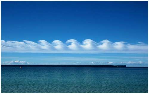
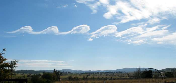
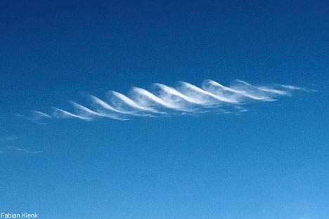
1- Kelvin Helmholtz Cirrus
# Distribution: Worldwide.
# Height: Above 16,500 feet.
# Cause: Saturation of an air mass at high levels, combined with wind shear.
# Associated Weather: None
# Hazard Warning: Moderate to severe levels of turbulence at cloud level.
Appearing as a slender, horizontal spiral of cloud, cirrus Kelvin-Helmholtz is one of the most distinctive cloud formations. However, it tends to dissipate only a minute or two after forming and, as a result, is rarely observed.
The shape of this kind of cirrus is the result of a particular type of wind shear. In general, wind shear occurs when one layer of air slides across another layer moving at a different speed or in a different direction (or both). This gives rise to vertical eddies that produce a regular pattern of air waves.
In most cases, wind shear creates a series of gently undulating cloud formations along the tops of the waves. In the case of the Kelvin-Helmholtz formation, however, the eddies are more powerful, and carry the cloud over the peak and down the other side, so that the waves "break" in the manner of ocean waves breaking as they approach the shore. As these waves complete a circulation, they create a distinctive corkscrew pattern.
This form of instability also occurs in fluids and in the Earth's outer atmosphere. It was first described in the late nineteenth century by Baron Kelvin (1824-1907), a Scottish physicist, and Hermann von Helmholtz (1821-94), a German physicist -- hence the name of the cloud.
Kelvin-Helmholtz waves are probably quite common in the upper troposphere, but generally there is insufficient moisture present to generate cloud and render the pattern visible.
The presence of this cloud indicates a degree of wind shear that is likely to produce moderate to severe turbulence at cloud level. In the absence of cloud, the same process can be a major source of clear air turbulence at high levels. As this turbulence is invisible and does not show up on radar, aircraft may encounter it unexpectedly.
SOURCE

In these times of troubles and bad news, I would like to bring in some beautiful pictures of rare and incredible clouds all around the world, just to show the beauty of our Earth and to release some pressure, even for a short moment... before going back to serious and mundane things.
-----------------------------------------------------------------------------------------
1- Kelvin Helmholtz Cirrus
# Distribution: Worldwide.
# Height: Above 16,500 feet.
# Cause: Saturation of an air mass at high levels, combined with wind shear.
# Associated Weather: None
# Hazard Warning: Moderate to severe levels of turbulence at cloud level.
Appearing as a slender, horizontal spiral of cloud, cirrus Kelvin-Helmholtz is one of the most distinctive cloud formations. However, it tends to dissipate only a minute or two after forming and, as a result, is rarely observed.
The shape of this kind of cirrus is the result of a particular type of wind shear. In general, wind shear occurs when one layer of air slides across another layer moving at a different speed or in a different direction (or both). This gives rise to vertical eddies that produce a regular pattern of air waves.
In most cases, wind shear creates a series of gently undulating cloud formations along the tops of the waves. In the case of the Kelvin-Helmholtz formation, however, the eddies are more powerful, and carry the cloud over the peak and down the other side, so that the waves "break" in the manner of ocean waves breaking as they approach the shore. As these waves complete a circulation, they create a distinctive corkscrew pattern.
This form of instability also occurs in fluids and in the Earth's outer atmosphere. It was first described in the late nineteenth century by Baron Kelvin (1824-1907), a Scottish physicist, and Hermann von Helmholtz (1821-94), a German physicist -- hence the name of the cloud.
Kelvin-Helmholtz waves are probably quite common in the upper troposphere, but generally there is insufficient moisture present to generate cloud and render the pattern visible.
The presence of this cloud indicates a degree of wind shear that is likely to produce moderate to severe turbulence at cloud level. In the absence of cloud, the same process can be a major source of clear air turbulence at high levels. As this turbulence is invisible and does not show up on radar, aircraft may encounter it unexpectedly.
SOURCE
edit on 12-3-2011 by elevenaugust because: fix box
edit on 12-3-2011 by elevenaugust because: (no reason given)
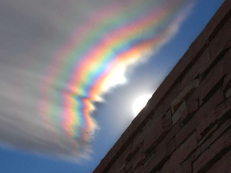
2- Iridescent clouds
Cloud iridescence is the occurrence of colors in a cloud not dissimilar to those seen in oil films on puddles, and is similar to irisation. It is a fairly uncommon phenomenon and is usually observed in altocumulus, cirrocumulus and lenticular clouds but very rarely in Cirrus clouds.
The colors are usually pastel but sometimes they can be very vivid. Iridescence is most frequently seen near to the sun with the sun's glare masking it. It is most easily seen by hiding the sun behind a tree or building. Other aids are dark glasses or observing the sky by its reflection in a convex mirror or in a pool of water.
Iridescent clouds are a diffraction phenomenon. Small water droplets or even small ice crystals in clouds individually scatter light. Large ice crystals produce halos, which are refraction phenomena rather than iridescence. Iridescence should similarly be distinguished from the refraction in larger raindrops that gives a rainbow. If parts of the clouds have droplets (or crystals) of similar size the cumulative effect is seen as colors.
The cloud must be optically thin so that most rays encounter only a single droplet. Iridescence is therefore mostly seen at cloud edges or in semi-transparent clouds. Newly forming clouds produce the brightest and most colorful iridescence because their droplets are of the same size.
When a thin cloud has droplets of similar size over a large extent the iridescence takes on a structured form to give a corona, a central bright disk around the sun or moon surrounded by one or more colored rings.
SOURCE

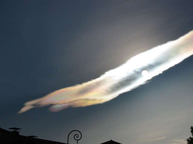
...Over Boulder (Colorado) Credits August Allen
Iridescence on Cirrus 1
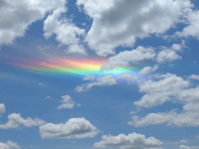
Iridescence on Cirrus 2
Iridescence on Cirrus 3
"Anvil-type" cumulo-nimbus cloud Iridescence
Cloud iridescence is the occurrence of colors in a cloud not dissimilar to those seen in oil films on puddles, and is similar to irisation. It is a fairly uncommon phenomenon and is usually observed in altocumulus, cirrocumulus and lenticular clouds but very rarely in Cirrus clouds.
The colors are usually pastel but sometimes they can be very vivid. Iridescence is most frequently seen near to the sun with the sun's glare masking it. It is most easily seen by hiding the sun behind a tree or building. Other aids are dark glasses or observing the sky by its reflection in a convex mirror or in a pool of water.
Iridescent clouds are a diffraction phenomenon. Small water droplets or even small ice crystals in clouds individually scatter light. Large ice crystals produce halos, which are refraction phenomena rather than iridescence. Iridescence should similarly be distinguished from the refraction in larger raindrops that gives a rainbow. If parts of the clouds have droplets (or crystals) of similar size the cumulative effect is seen as colors.
The cloud must be optically thin so that most rays encounter only a single droplet. Iridescence is therefore mostly seen at cloud edges or in semi-transparent clouds. Newly forming clouds produce the brightest and most colorful iridescence because their droplets are of the same size.
When a thin cloud has droplets of similar size over a large extent the iridescence takes on a structured form to give a corona, a central bright disk around the sun or moon surrounded by one or more colored rings.
SOURCE
...Over Boulder (Colorado) Credits August Allen
Iridescence on Cirrus 1
Iridescence on Cirrus 2
Iridescence on Cirrus 3
"Anvil-type" cumulo-nimbus cloud Iridescence
Very beautiful photos! S&F..It makes you forget about how terrible of a place this planet is..Even if it is just for a second.
awesome! thx for sharing. gets my mind off the end of the world (happening now).
here are some more
www.hongkiat.com...
here are some more
www.hongkiat.com...
3- Altocumulus Castelanus
This amazing and rare cloud formation, also known as "jellyfish clouds"because of their appearance, are formed around 5000 meters (16000 feet) above sea level when the moist air from the Gulf Stream is trapped between layers of dry air. The upper part of the cloud-shaped jellyfish with long tentacles ("Virga") is formed with the evaporation of raindrops from the bottom.
SOURCE
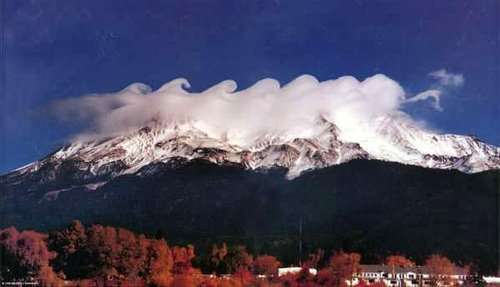
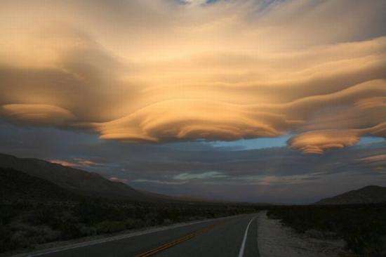
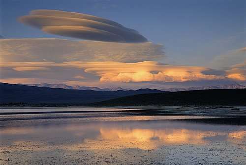
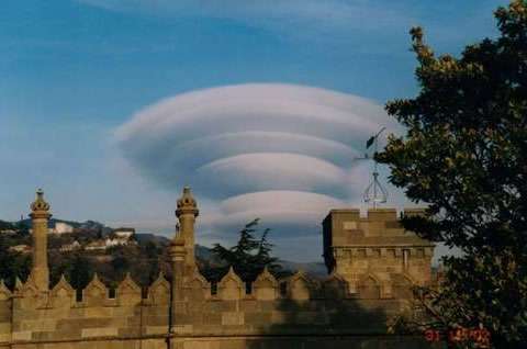
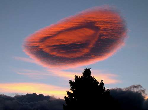
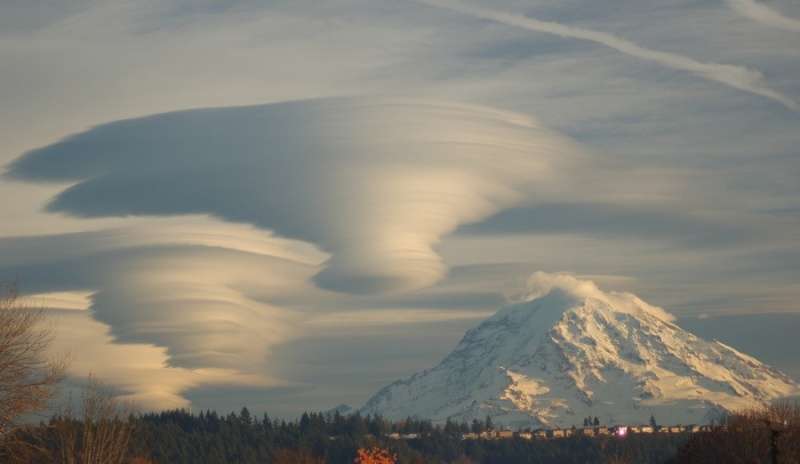
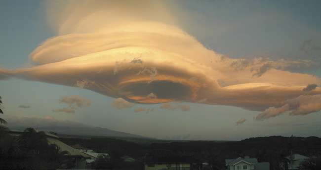
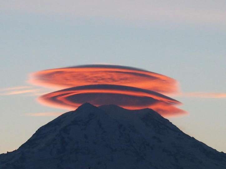
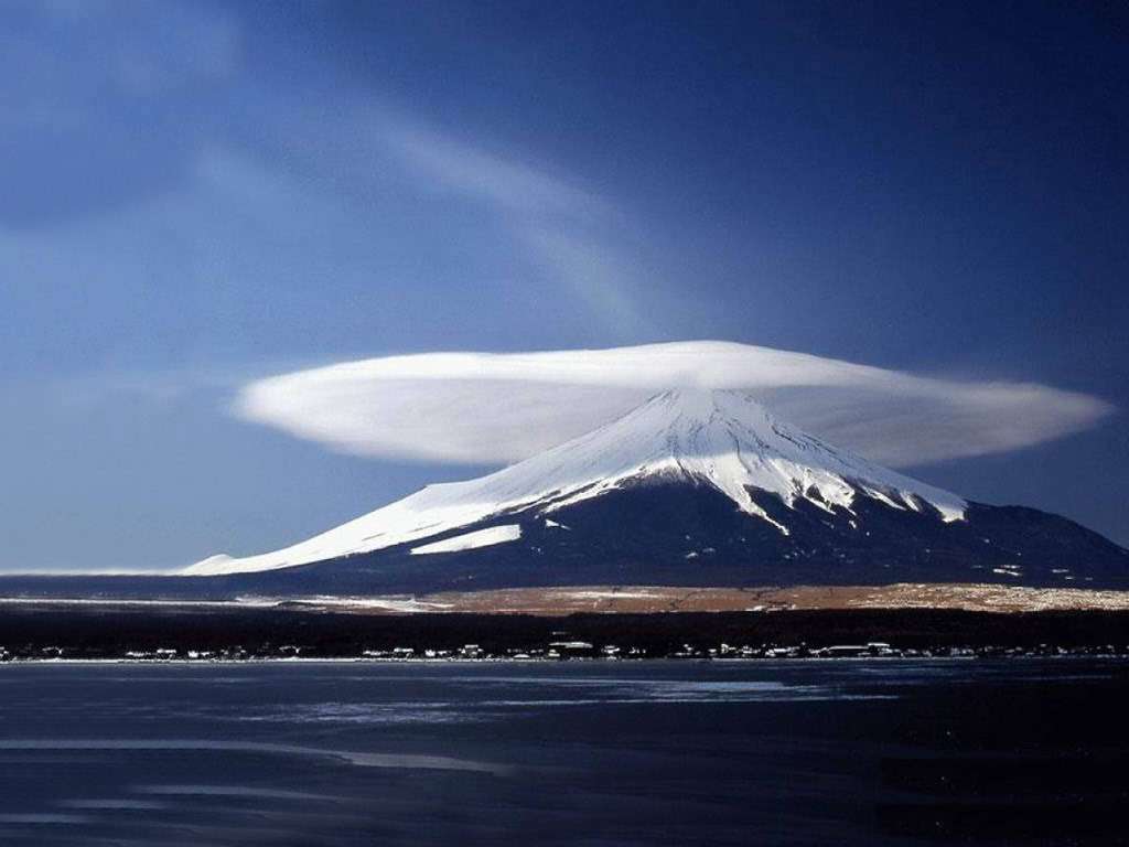
4- Lenticular clouds
Lenticular clouds (Altocumulus lenticularis) are stationary lens-shaped clouds that form at high altitudes, normally aligned perpendicular to the wind direction. Lenticular clouds can be separated into altocumulus standing lenticularis (ACSL), stratocumulus standing lenticular (SCSL), and cirrocumulus standing lenticular (CCSL). Due to their shape, they are often mistaken as Unidentified Flying Objects (UFOs).
SOURCE
reply to post by elevenaugust
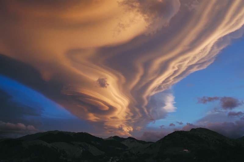
Wow. ...The pics in the OP really do look like waves on the ocean. Magnificent!
S&F&
Wow. ...The pics in the OP really do look like waves on the ocean. Magnificent!
S&F&


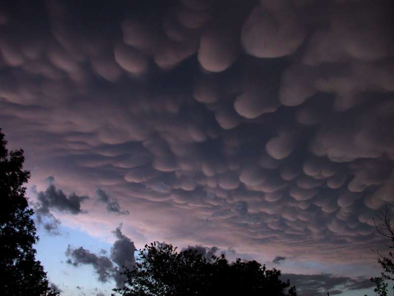
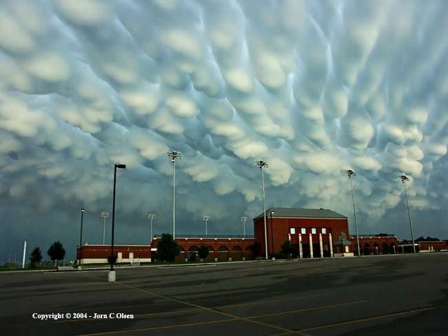
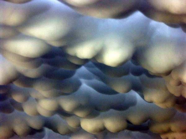
5- Mammatus clouds
Mammatus, also known as mammatocumulus (meaning "mammary cloud" or "breast cloud"), is a meteorological term applied to a cellular pattern of pouches hanging underneath the base of a cloud. The name mammatus, derived from the Latin mamma (meaning "udder" or "breast"), refers to a resemblance between the characteristic shape of these clouds and the breast of a woman.
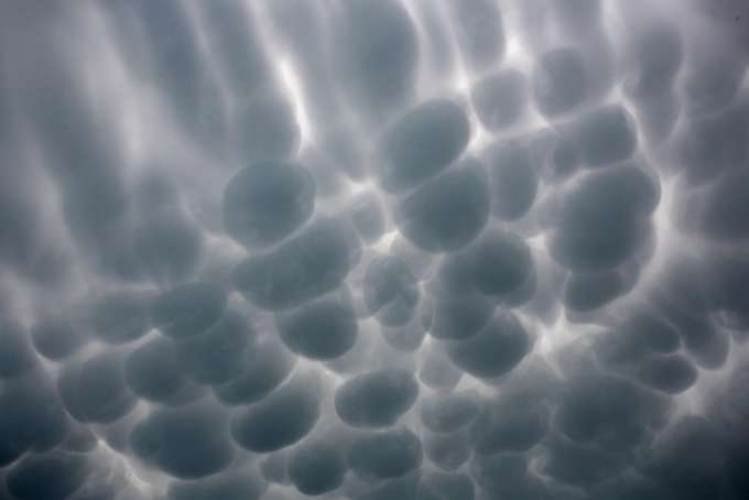
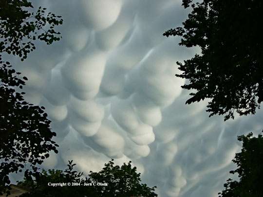
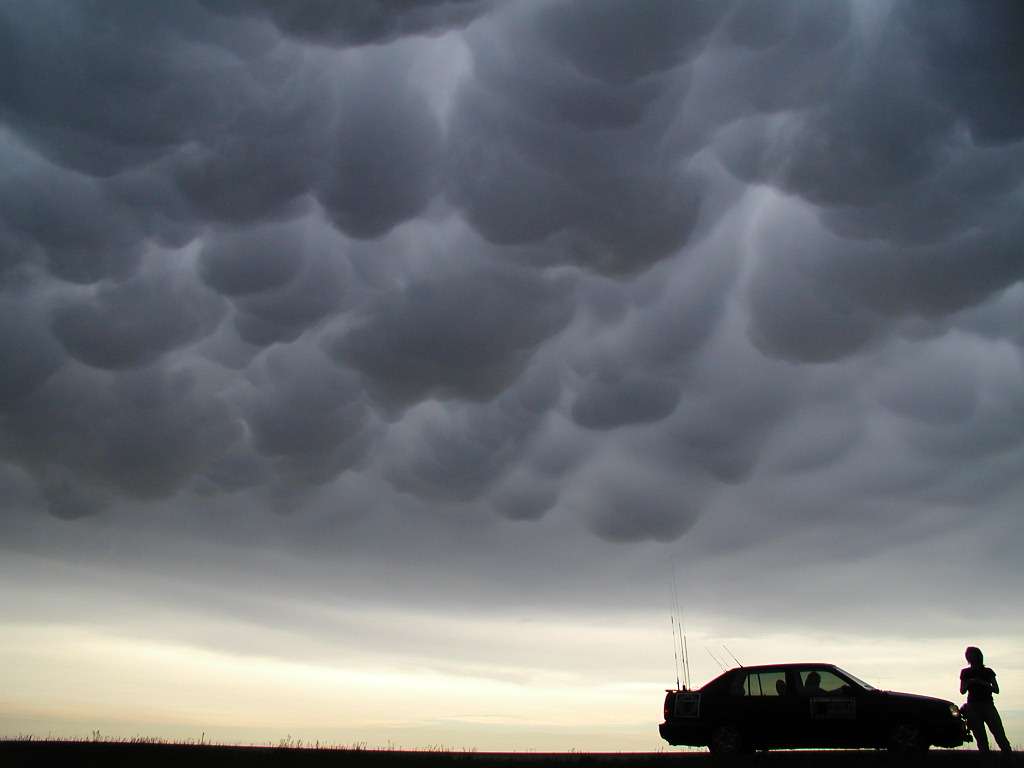
Mammatus, also known as mammatocumulus (meaning "mammary cloud" or "breast cloud"), is a meteorological term applied to a cellular pattern of pouches hanging underneath the base of a cloud. The name mammatus, derived from the Latin mamma (meaning "udder" or "breast"), refers to a resemblance between the characteristic shape of these clouds and the breast of a woman.

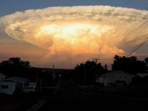
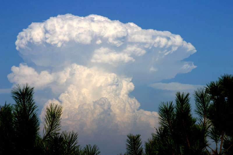
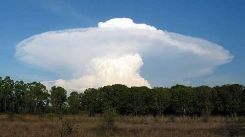
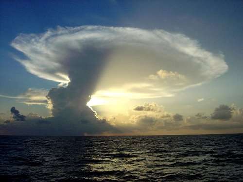
6- "Mushroom" clouds
This somewhat fanciful term refers to the general form taken by some convective clouds with strong vertical elevation, especially at the top of cumulonimbus clouds, sometimes shaped like an anvil. (cumulonimbus, nimbus capillatus Incus) Its ultimate summit, for the largest of them can even reach the stratosphere (8-20km altitude) as a dome or apex protruding.
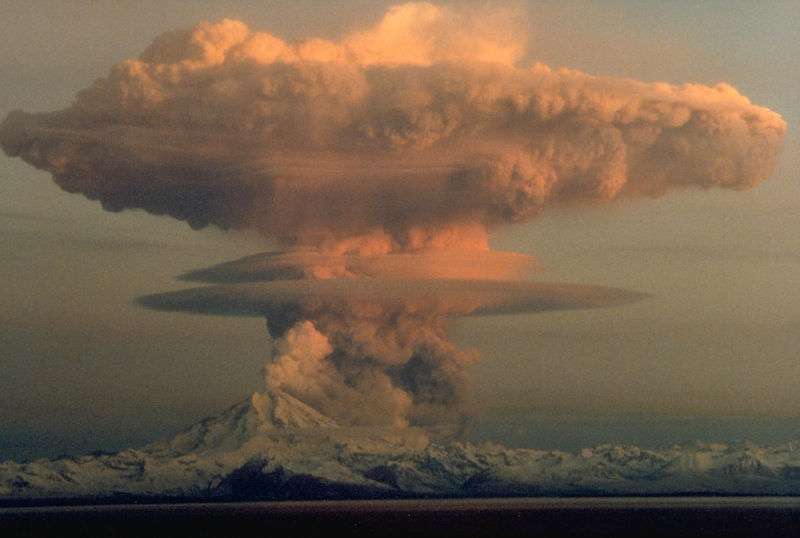
Mont Redoubt Eruption, 1990 (Alaska)

Rather altocumulus Lenticularis kind
The dome is clearly visible here, above the anvil
End life Cumulo-nimbus, with its persistent anvil
This somewhat fanciful term refers to the general form taken by some convective clouds with strong vertical elevation, especially at the top of cumulonimbus clouds, sometimes shaped like an anvil. (cumulonimbus, nimbus capillatus Incus) Its ultimate summit, for the largest of them can even reach the stratosphere (8-20km altitude) as a dome or apex protruding.
Mont Redoubt Eruption, 1990 (Alaska)
Rather altocumulus Lenticularis kind
The dome is clearly visible here, above the anvil
End life Cumulo-nimbus, with its persistent anvil
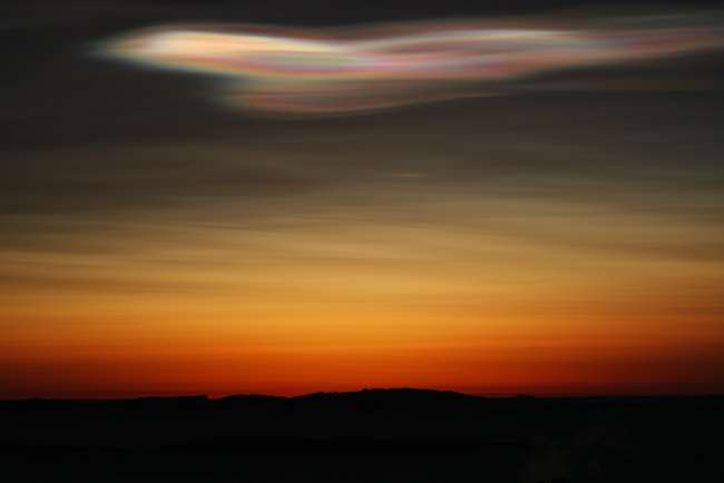
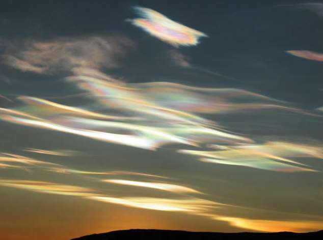
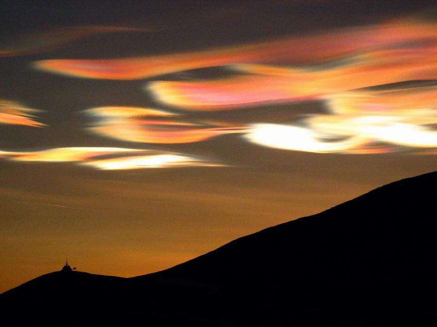
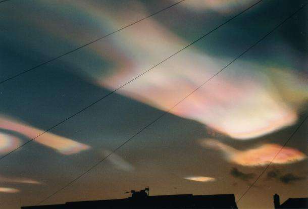
7- Polar stratospheric clouds
Polar stratospheric clouds (PSCs), also known as nacreous clouds (from nacre, or mother of pearl, due to its iridescence), are clouds in the winter polar stratosphere at altitudes of 15,000–25,000 meters (50,000–80,000 ft).
They are implicated in the formation of ozone holes; their effects on ozone depletion arise because they support chemical reactions that produce active chlorine which catalyzes ozone destruction, and also because they remove gaseous nitric acid, perturbing nitrogen and chlorine cycles in a way which increases ozone destruction.
SOURCE
reply to post by westcoast
Wow! Beautiful shoots!
Thanks for these pictures.
Did you try to put a name on each of these clouds? (Especially the first ones that I have some difficulties to recognize)
Wow! Beautiful shoots!
Thanks for these pictures.
Did you try to put a name on each of these clouds? (Especially the first ones that I have some difficulties to recognize)
Needed the distraction too...
So beautifull...
Words don´t apply.
Thankyou!
So beautifull...
Words don´t apply.
Thankyou!
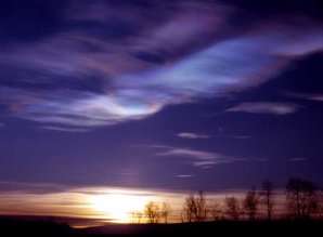
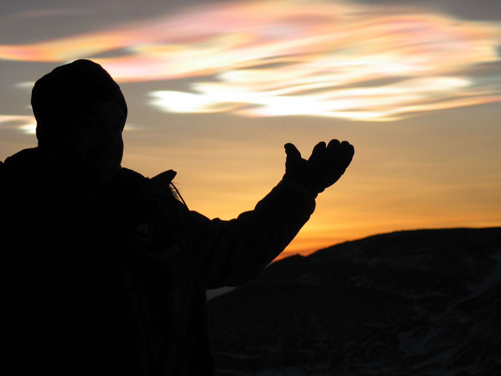
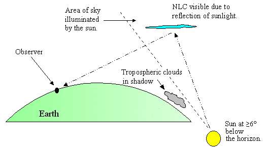
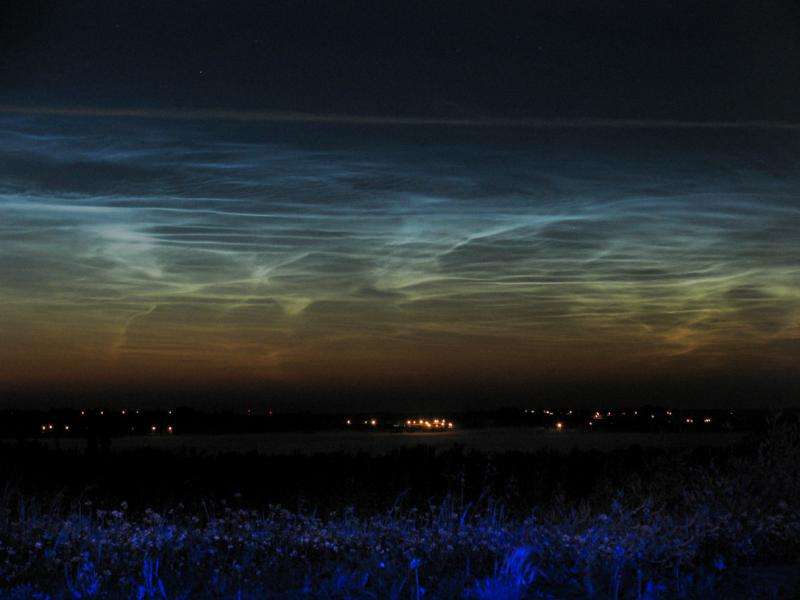
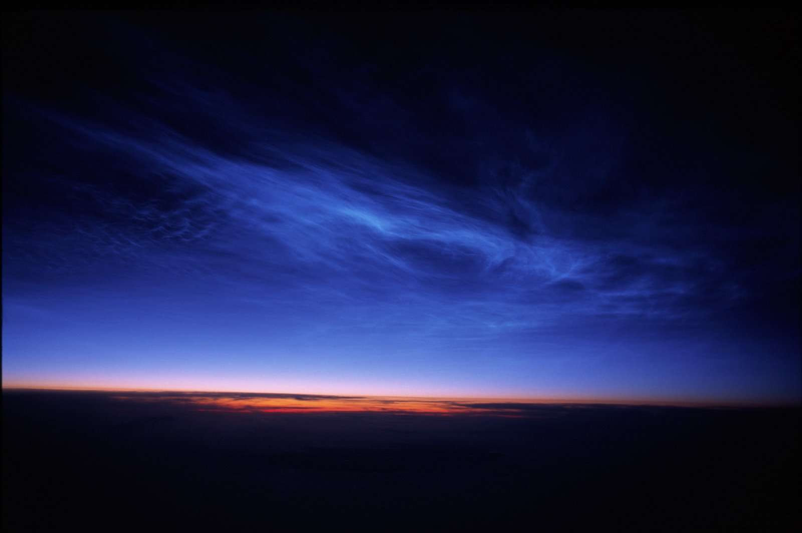
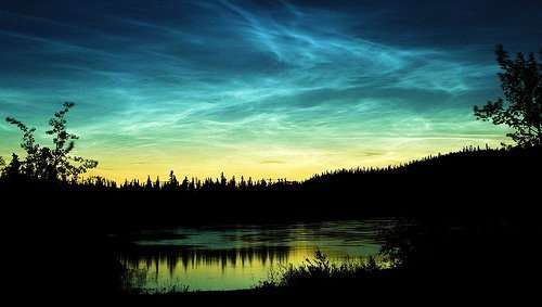
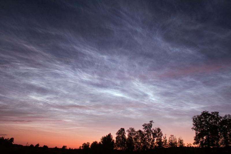
8- Noctilucent clouds
Noctilucent clouds are tenuous cloud-like phenomena that are the "ragged-edge" of a much brighter and pervasive polar cloud layer called polar mesospheric clouds in the upper atmosphere, visible in a deep twilight.
They are made of crystals of water ice. The name means roughly night shining in Latin. They are most commonly observed in the summer months at latitudes between 50° and 70° north and south of the equator.
They are the highest clouds in the Earth's atmosphere, located in the mesosphere at altitudes of around 76 to 85 kilometers (47 to 53 miles). They are normally too faint to be seen, and are visible only when illuminated by sunlight from below the horizon while the lower layers of the atmosphere are in the Earth's shadow.
Noctilucent clouds are not fully understood and are a recently discovered meteorological phenomenon; there is no evidence that they were observed before 1885.
Noctilucent clouds can form only under very restrictive conditions; their occurrence can be used as a sensitive guide to changes in the upper atmosphere. Since their relatively recent classification, the occurrence of noctilucent clouds appears to be increasing in frequency, brightness and extent. It is theorized that this increase is connected to climate change.
SOURCE
Wow- amazing finds and thank you for sharing OP! =D I have several impressive pix and vids from here in Texas- thinking I'll go dig them up and
share...
It's really nice to have the positive aspect of mother nature- considering the state of things.
It's really nice to have the positive aspect of mother nature- considering the state of things.
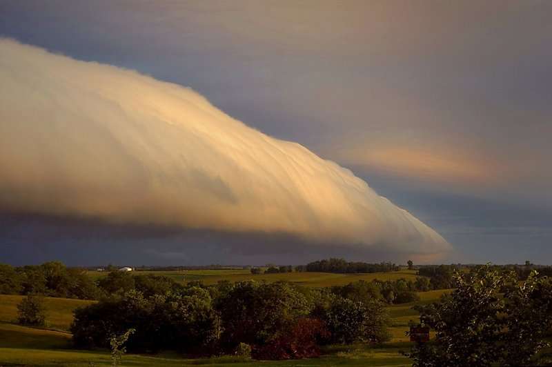
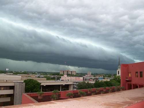
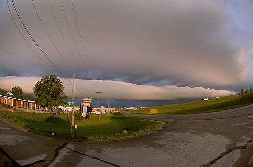
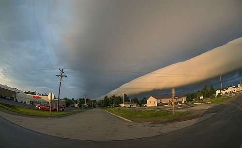
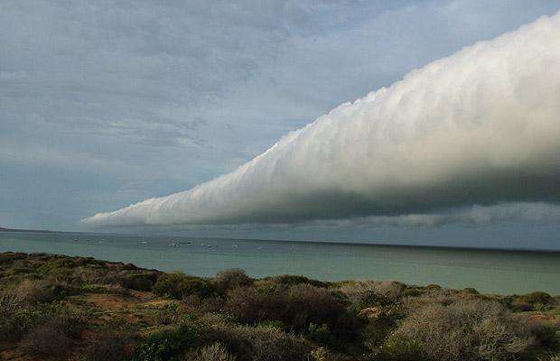
9- Roll clouds
A roll cloud is a low, horizontal, tube-shaped, and relatively rare type of arcus cloud. They differ from shelf clouds by being completely detached from other cloud features. Roll clouds usually appear to be "rolling" about a horizontal axis.
They can be described as a solitary wave or a soliton, which is a wave that has a single crest and moves without changing speed or shape. One of the most famous frequent occurrences is the Morning Glory cloud in Queensland, Australia. One of the main causes of the Morning Glory cloud is the mesoscale circulations associated with sea breezes that develop over the Cape York peninsula and the Gulf of Carpentaria.
However similar features can be created by downdrafts from thunderstorms and are not exclusively associated with coastal regions. Coastal roll clouds have been seen over California, the English Channel, Shetland Islands, Lithuania, Eastern Russia, other maritime regions of Australia, off the Mexican coast in the Sea of Cortez, Uruguay, in the Canadian provinces of Nova Scotia and Ontario and Campos dos Goytacazes and Coronel Vivida bay in Brazil.
SOURCE
new topics
-
BIDEN Admin Begins Planning For January 2025 Transition to a New President - Today is 4.26.2024.
2024 Elections: 1 hours ago -
Big Storms
Fragile Earth: 3 hours ago -
Where should Trump hold his next rally
2024 Elections: 5 hours ago -
Shocking Number of Voters are Open to Committing Election Fraud
US Political Madness: 6 hours ago -
Gov Kristi Noem Shot and Killed "Less Than Worthless Dog" and a 'Smelly Goat
2024 Elections: 7 hours ago -
Falkville Robot-Man
Aliens and UFOs: 7 hours ago -
James O’Keefe: I have evidence that exposes the CIA, and it’s on camera.
Whistle Blowers and Leaked Documents: 8 hours ago -
Australian PM says the quiet part out loud - "free speech is a threat to democratic dicourse"...?!
New World Order: 9 hours ago -
Ireland VS Globalists
Social Issues and Civil Unrest: 9 hours ago -
Biden "Happy To Debate Trump"
2024 Elections: 10 hours ago
top topics
-
James O’Keefe: I have evidence that exposes the CIA, and it’s on camera.
Whistle Blowers and Leaked Documents: 8 hours ago, 14 flags -
Australian PM says the quiet part out loud - "free speech is a threat to democratic dicourse"...?!
New World Order: 9 hours ago, 13 flags -
Blast from the past: ATS Review Podcast, 2006: With All Three Amigos
Member PODcasts: 12 hours ago, 13 flags -
Biden "Happy To Debate Trump"
2024 Elections: 10 hours ago, 12 flags -
Mike Pinder The Moody Blues R.I.P.
Music: 12 hours ago, 8 flags -
What is the white pill?
Philosophy and Metaphysics: 11 hours ago, 6 flags -
Shocking Number of Voters are Open to Committing Election Fraud
US Political Madness: 6 hours ago, 6 flags -
RAAF airbase in Roswell, New Mexico is on fire
Aliens and UFOs: 10 hours ago, 5 flags -
Ireland VS Globalists
Social Issues and Civil Unrest: 9 hours ago, 5 flags -
Where should Trump hold his next rally
2024 Elections: 5 hours ago, 5 flags
active topics
-
Gov Kristi Noem Shot and Killed "Less Than Worthless Dog" and a 'Smelly Goat
2024 Elections • 49 • : AwakeNotWoke -
Biden "Happy To Debate Trump"
2024 Elections • 50 • : Lumenari -
Falkville Robot-Man
Aliens and UFOs • 9 • : CosmicFocus -
Big Storms
Fragile Earth • 12 • : Lumenari -
BIDEN Admin Begins Planning For January 2025 Transition to a New President - Today is 4.26.2024.
2024 Elections • 8 • : NoCorruptionAllowed -
ALERT - U.S. President JOE BIDEN Examined and Found NOT OF SOUND MIND.
2024 Elections • 65 • : SchrodingersRat -
James O’Keefe: I have evidence that exposes the CIA, and it’s on camera.
Whistle Blowers and Leaked Documents • 13 • : theatreboy -
Where should Trump hold his next rally
2024 Elections • 21 • : Dandandat3 -
RAAF airbase in Roswell, New Mexico is on fire
Aliens and UFOs • 9 • : Degradation33 -
President BIDEN's FBI Raided Donald Trump's Florida Home for OBAMA-NORTH KOREA Documents.
Political Conspiracies • 38 • : SchrodingersRat