It looks like you're using an Ad Blocker.
Please white-list or disable AboveTopSecret.com in your ad-blocking tool.
Thank you.
Some features of ATS will be disabled while you continue to use an ad-blocker.

Major Hurricane Ike
page: 13share:
reply to post by Hellmutt
Great pictures some very scary looking data, however this picture really looks like an eye in the storm...

Great pictures some very scary looking data, however this picture really looks like an eye in the storm...
anatar, I'm not sure what the water vapour image of the Atlantic is for?
As for what's going on in Houston.
I have been talking to a friend up until a few seconds ago, I believe her power must've died. I don't know much, but there are quite a few areas in Houston that weren't evacuated, hers being one of them. From what I know...Galveston is under water though now.
[edit on 13.9.2008 by Shugo]
Yeah, something about the ... 1st level of the hospital, west Galveston is taking water. It's not even the worst yet? Waves are coming over the
walls. Flooding sounds like... huge potential?
reply to post by Shugo
I am with you, I know this is so freaking upsetting, hence it is 130 am here and I am up, waiting, just concerned about this situation and the people suffering, large parts of Galvaston underwater now... Wow, tens of thousans still on Galvastan Island. Pray for the children, the parents need to be up on charges.
I am with you, I know this is so freaking upsetting, hence it is 130 am here and I am up, waiting, just concerned about this situation and the people suffering, large parts of Galvaston underwater now... Wow, tens of thousans still on Galvastan Island. Pray for the children, the parents need to be up on charges.
They were saying the risks in order of severity were going to be flooding, in attribution to storm surge and heavy rainfall of over 14 inches in some
areas, followed by wind, and then severe weather. Something Ike has with it, is all factors...this really could be more devistating than Katrina.
Ike is to make landfall on the mainland in the next few minutes, if he hasn't done so already...I'm looking at radar images, but am unable to actually see if he's made landfall due to radar distortion.
Ike is to make landfall on the mainland in the next few minutes, if he hasn't done so already...I'm looking at radar images, but am unable to actually see if he's made landfall due to radar distortion.
Reports that frantic calls for rescue continue to come in hard & fast to Galveston 911. Still no chance of rescue until Saturday morning.
It seems that the eyewall has passed over Galveston. Ike is so massive that it's hard to tell where official landfall will be (official landfall is measured when the exact center of the storm passes over land), but to my eye it looks like it'll be left of downtown Galveston, probably over by Jamaica Beach.
Pressure in Galv. is down to 953mb; looks like they're indeed in the eye.
Storm surge at Galv. is 12.33' currently. It's going to go up once the eye passes and the dirty south side of the storm reaches land.
Over 1 million without power.
...latest from the AP:
www.nytimes.com...
[edit on 13-9-2008 by arktkchr]
Wind-whipped waves surged over a 17-foot seawall in Galveston and filled streets with waist-high water. Homes were flooding, utilities said more than 4.5 million people were without power and there was fear hurricane-force winds could shatter the windows of the sparkling skyscrapers that define the skyline of America's fourth-largest city.
Rescue crews worried daybreak would bring a nightmare scenario: Thousands who defied evacuation orders and became trapped in submerged communities. Already, dozens of calls had come into 911 dispatchers begging for help.
Firefighters left three buildings to burn Galveston because water was too high for fire trucks to reach them. But there was some good news: a stranded freighter with 22 men aboard made it through the brunt of the storm safely, and a tugboat was on the way to save them.
www.nytimes.com...
[edit on 13-9-2008 by arktkchr]
As Hurricane Ike pushed a swelling surge onto Galveston Island this morning, many of the estimated 23,000 Galveston residents who ignored a mandatory evacuation order phoned for rescues to no avail because emergency workers were called off the streets, officials said.
Help wasn't expected until after dangerous storm conditions subsided.
"We don't know what we're going to find tomorrow," said the city's mayor, Lyda Ann Thomas. "We hope we'll find that the people who didn't leave here are alive and well."
City Manager Steve LeBlanc went so far as to ask the media not to photograph "certain things" in the aftermath, referring to the possibility of dead bodies.
chron.com
Stormpulse site has user-friendly tracking:
www.stormpulse.com...
voices.washingtonpost.com...
[edit on 13-9-2008 by arktkchr]
www.stormpulse.com...
voices.washingtonpost.com...
[edit on 13-9-2008 by arktkchr]
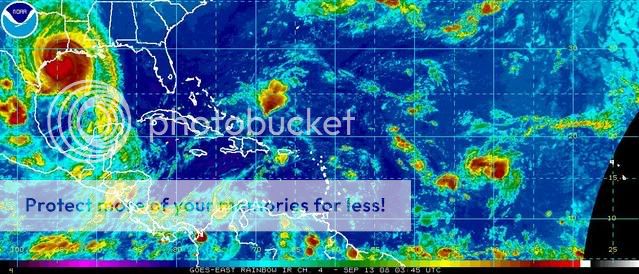
Check out this NOAA rainbow picture, it shows the trail of very bad looking hotspots still rolling in long after the main body of the storm passes
over.
Six feet of water in the Galveston courthouse and surrounding areas.
-KFDM
Seven feet of water in The Strand in Galveston
-KPRC
Clear Lake, TX: aerial shots of a parking lot completely inundated with several feet of water with whitecaps breaking.
-TWC
Official landfall appears to be happening right now, ~3:20am EST
-KFDM
Seven feet of water in The Strand in Galveston
-KPRC
Clear Lake, TX: aerial shots of a parking lot completely inundated with several feet of water with whitecaps breaking.
-TWC
Official landfall appears to be happening right now, ~3:20am EST
I need to get some sleep, gang. Was gonna try and make it longer but I'm nodding off at the computer.
Daylight will tell us how bad this was...until then, we can only hope for the best.
Daylight will tell us how bad this was...until then, we can only hope for the best.
reply to post by antar
If you click the small pictures on that page, you'll get a bigger picture. And the picture you'll see is automatically saved on climatepatrol's server, so you don't have to host them yourself, and can post them using im-tags. Like this:
Here's the link to the feeds again:
www.climatepatrol.com...
If you click the small pictures on that page, you'll get a bigger picture. And the picture you'll see is automatically saved on climatepatrol's server, so you don't have to host them yourself, and can post them using im-tags. Like this:
Here's the link to the feeds again:
www.climatepatrol.com...
Oh man, thanks for all the updates. Work is SOOOOO busy tonite, making it so hard to get updates myself, or even here... Off soon, then catching up.
Good work
Two hours after landfall winds are still 110, and eye is clearly visible going right up Houston Bay. This at least keeps Houston out of the right
front quadrant. I thought the eye would break up quickly, but it is still a hurricane and well organized.
Its over the Houston Ship Channel. so despite landfall, its still over water.
The eye was said to have passed over Galveston bay.
There is flooding along the southern end of the bayous. White Oak north of downtown is at 40 feet with flood level at 32 feet. Looks like a bit a Allison-like flooding might occur again. Lots of street flooding.
Just checked with the first family members in Houston, they are OK. More to go.
Edit: virtually all of Houston served by above ground electrical service is without power. Only downtown and med center are with power.
[edit on 9/13/2008 by roadgravel]
Originally posted by KMFNWO
Its over the Houston Ship Channel. so despite landfall, its still over water.
Immediate economic impact:
Forecasters warned Ike would send water surging up the Houston Ship Canal, the second-busiest U.S. port, a complex of docks, pipelines, depots and warehouses that receives automobiles, consumer products, industrial equipment and other cargo from around the world.
www.swissinfo.ch...
Live-feed link, Houston station KPRC:
www.msnbc.msn.com...
[edit on 13-9-2008 by arktkchr]
new topics
-
BIDEN Admin Begins Planning For January 2025 Transition to a New President - Today is 4.26.2024.
2024 Elections: 3 hours ago -
Big Storms
Fragile Earth: 4 hours ago -
Where should Trump hold his next rally
2024 Elections: 7 hours ago -
Shocking Number of Voters are Open to Committing Election Fraud
US Political Madness: 8 hours ago -
Gov Kristi Noem Shot and Killed "Less Than Worthless Dog" and a 'Smelly Goat
2024 Elections: 8 hours ago -
Falkville Robot-Man
Aliens and UFOs: 9 hours ago -
James O’Keefe: I have evidence that exposes the CIA, and it’s on camera.
Whistle Blowers and Leaked Documents: 9 hours ago -
Australian PM says the quiet part out loud - "free speech is a threat to democratic dicourse"...?!
New World Order: 10 hours ago -
Ireland VS Globalists
Social Issues and Civil Unrest: 11 hours ago -
Biden "Happy To Debate Trump"
2024 Elections: 11 hours ago
top topics
-
James O’Keefe: I have evidence that exposes the CIA, and it’s on camera.
Whistle Blowers and Leaked Documents: 9 hours ago, 17 flags -
Australian PM says the quiet part out loud - "free speech is a threat to democratic dicourse"...?!
New World Order: 10 hours ago, 15 flags -
Blast from the past: ATS Review Podcast, 2006: With All Three Amigos
Member PODcasts: 13 hours ago, 13 flags -
Biden "Happy To Debate Trump"
2024 Elections: 11 hours ago, 13 flags -
Ireland VS Globalists
Social Issues and Civil Unrest: 11 hours ago, 9 flags -
Mike Pinder The Moody Blues R.I.P.
Music: 13 hours ago, 8 flags -
BIDEN Admin Begins Planning For January 2025 Transition to a New President - Today is 4.26.2024.
2024 Elections: 3 hours ago, 7 flags -
What is the white pill?
Philosophy and Metaphysics: 13 hours ago, 6 flags -
Shocking Number of Voters are Open to Committing Election Fraud
US Political Madness: 8 hours ago, 6 flags -
Big Storms
Fragile Earth: 4 hours ago, 6 flags
active topics
-
Australian PM says the quiet part out loud - "free speech is a threat to democratic dicourse"...?!
New World Order • 7 • : 19Bones79 -
It takes One to Be; Two to Tango; Three to Create.
Philosophy and Metaphysics • 8 • : Compendium -
Big Storms
Fragile Earth • 16 • : rickymouse -
James O’Keefe: I have evidence that exposes the CIA, and it’s on camera.
Whistle Blowers and Leaked Documents • 14 • : 19Bones79 -
BIDEN Admin Begins Planning For January 2025 Transition to a New President - Today is 4.26.2024.
2024 Elections • 18 • : rickymouse -
RAAF airbase in Roswell, New Mexico is on fire
Aliens and UFOs • 12 • : pianopraze -
A Warning to America: 25 Ways the US is Being Destroyed
New World Order • 29 • : 19Bones79 -
What is the white pill?
Philosophy and Metaphysics • 22 • : AlexandrosOMegas -
University of Texas Instantly Shuts Down Anti Israel Protests
Education and Media • 315 • : CriticalStinker -
Gov Kristi Noem Shot and Killed "Less Than Worthless Dog" and a 'Smelly Goat
2024 Elections • 58 • : cherokeetroy