It looks like you're using an Ad Blocker.
Please white-list or disable AboveTopSecret.com in your ad-blocking tool.
Thank you.
Some features of ATS will be disabled while you continue to use an ad-blocker.

C-130 video confirms 84th RADES Data
page: 11share:
Originally posted by SPreston
Originally posted by Reheat
Originally posted by SPreston
Also according to the faked RADES, the C-130 was still facing southwest at 9:37 the alleged impact time and O'Brien was sitting in the port pilot's seat, so how could O'Brien have seen the alleged impact?
The C-130 was heading NE toward the Pentagon at the impact time.
O'Brien did not state that he witnessed the impact, you're fabricating something he never stated.
How could O'Brien be flying Northwest towards the Pentagon when your faked RADES had him flying 15 miles southwest, past the Pentagon, and leaving him southwest of the Pentagon?
No wonder you don't have a clue.]/quote]
You knew exactly what I meant, so don't play dumb. He was heading North East toward the Pentagon and I have corrected the typo in my original post and in the quote above. It is getting late and I'm exhausted after a long day. Take advantage of it because it won't happen again.
I see you didn't retract your implication that O'Brien said he saw the impact when that's not what he said at all. Don't you think an honest person would retract an implication like that in the interest of accuracy.
Originally posted by SPreston
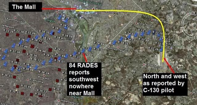
C-130 flight path (Yellow line) - Faked RADES C-130 flight path (blue) - Faked Flight 77 (red)
Decoy aircraft spotted by O'Brien to the west after C-130 passed the Mall
You have been shown repeatedly how and why this is wrong by people qualified to interpret it. Maybe if you repeat it enough times you'll eventually believe it.
Both Beachnut and I have told you it's wrong, but you repeat it over and over as if that will make it true. It won't, your wrong and you can't connect your fantasy flight path with the hard evidence of the Tribby video/Looney photographs.
You have failed to prove the OP wrong.
[edit on 24-8-2008 by Reheat]
[edit on 24-8-2008 by Reheat]
[edit on 24-8-2008 by Reheat]
You proved Reheat was correct.
Originally posted by beachnut
Well i have to correct that statement becasue it sure seemed like he was stating the pilot saw nothing.
Specailly since Reheat has never posted any real evindece asked for.
reply to post by SPreston
SPreston, like the other girls over at PffT, doesn't know dick about aircraft or the related procedures.
The C-130 would not be flying 300 mph. At max, with FAA restrictions to 250 knots (288 mph) below 10,000, that would be the maximum speed the aircraft would have been flying.
Departing aircraft ROUTINELY (let me repeat that...ROUTINELY) get vectors in a direction different from their destination for traffic or any number of other reasons. They'll get cleared to a waypoint or an enroute fix initially for control purposes and THEN they can get or are given clearance on their route. It would be 10 or 15 minutes whenever we would depart Calverton with an F-14 bound for San Diego before we would even THINK of asking for IINS direct NKX.
Keep in mind the altitude the C-130 was cleared to on its departure - 3,000ft. Approach plates for Reagan National (I just picked the ILS Rwy 1 for a representative example), when approaching the airport from the south, have a hard at or above altitude of 2,500 at 10.7 miles south of DCA at the PISCA Intersection, just slightly southeast of Mt Vernon. The next letdown altitude is at point OXONN, which has an at or above altitude of 1,600 ft at 5.1 miles, or just to the southwest of Bell Haven, VA and south of the Woodrow Wilson Bridge. In other words, PLENTY low for Andrews departing aircraft to be well above any aircraft on approach to DCA.
The whole "south of the mall" argument from the PffT girls hinges on a controller vectoring an aircraft, in that situation, directly alongside the most secure airspace in American and possibly the world and directly over the departure corridor that day for DCA. A few points on this:
1) I have *never*, in nearly 10 years of living and working in the DC area, *ever* seen *any* aircraft fly that route - along Independence Ave immediately south of P-56. No controller would ever do that. Doesn't happen, and to subscribe to that belief shows crystal clear ignorance of aeronautical procedures.
2) Anyone who has flown out of DCA on a northern departure knows that, even with noise abatement procedures, the aircraft climb in as expeditious manner as possible - a safe rate of climb to 1,500 feet then at 500 FPM climb rate until the 10 DME arc. When you leave DCA, you are passing right through that 3,000 altitude that the C-130 would have been at. Again, simply would not have happened.
As far as the timing of the impact and the positions of the two aircraft involved (AA77 and Gopher 06), until the PffT boys prove that all clocks and chronological devices referred to were synchronized to the second, any comparison of timing events is null and void and any references to shall be moot and not acknowledged as fact. From clocks in the Pentagon to RADES data to digital television archives to watches on peoples wrists, everyone has a slightly different time. As far as I'm concerned, the time of impact comes from my own eyewitness and earwitness account. I saw the still-billowing smoke pillar, I'd estimate 150 feet in the air and climbing, about 2 seconds after Miklaszewski said his "it seemed like a few moments ago there was an explosion at the Pentagon" comment, which established an impact time, using those parameters and data (the digital time stamp off the archives recording), at 09:39:00, give or take a handful of seconds.
And don't go off hollering that I acknowledged that it was an "explosion" vice the aircraft impact. Miklaszewski was using language based on what he felt - not what actually happened.
SPreston, go back to your PffT tree fort and remind Captain Bob of these issues.
[edit on 24-8-2008 by pinch]
pinch
The C-130 would not be flying 300 mph. At max, with FAA restrictions to 250 knots (288 mph) below 10,000, that would be the maximum speed the aircraft would have been flying.
Well gee willikers, I was just going by the average speed represented by the blue stickpins in the faked RADES data, Mr Bill Paisley. No greater authority than Mr Reheat himself authorized the use of the lytetrip RADES data map with the blue stickpins in his OP. It does equate to an average C-130 speed of 300 mph does it not?
SPreston posted on 8/23/08 @ 20:49
According to the faked RADES, the C-130 took about 3 minutes to fly the 15 mile leg to the southwest. That works out to about 300 mph. Also according to the faked RADES, the C-130 was still facing southwest at 9:37 the alleged impact time and O'Brien was sitting in the port pilot's seat, so how could O'Brien have seen the alleged impact?
The alleged C-130 according to the faked RADES and represented by the blue stickpins did fly approximately 15 miles to the southwest on a straight leg did it not? That does equal an average of 300 mph using simple math does it not? What do you get using the Amazing Randi Mathematics of Magicians, Illusionists, and Frauds? Something different? The same? So what are you whining about pinch? What is this deep seated fear by pseudoskeptics and government loyalists to ever admit they are wrong?
reply to OP post by Reheat
RADES Data (shown with blue stick pins): (full map)
Reheat posted on 8/14/08 @ 15:40
The RADES path is posted in the OP. The one I posted appears to be like all I have seen. I don't see any reason it question it.
On the same RADES map with the Reheat golden seal of approval, the alleged Flight 77 with stolen Romulan technology flies the 5+ mile distance from stickpin 9:36:48 to the Pentagon in 12 seconds for an amazing supersonic speed of 1501.2 mph. How do you explain that discrepency in the data? Somebody goofed in the illegal evidence counterfeiting department 4 years after 9-11? This is just simple math also. Any 5th grader or greater should be able to handle it. Having difficulty? So does Reheat and beachnut; lots and lots of difficulty. You still do not think the 84th RADES data was faked, pinch?
SPreston posted on 8/23/08 @ 23:31
Another huge discrepancy in the faked 84th RADES data, which I have just noticed. I want you Reheat and beachnut to have the pleasure to see it first, so you can get your denial act fully in gear. Go for the gold guys.
At the 9:38 blue stickpin (C-130) which is next to the 9:36:48 red stickpin, (Flt 77) the alleged 757 has 12 seconds to reach the Pentagon wall at the official 9:37 time. By measuring, I have determined the distance from that position to the Pentagon to be 5+ miles. Dividing 5 miles by 12 seconds gives a result of .417 miles per second. Multiplying .417 by 60 gives a result of 25.02 miles per minute. Multiplying 25.02 by 60 gives a result of 1501.2 mph. That is one fast little 757.
Did you do that Reheat?
1501.2 mph for an ordinary 757 without rocket assists?
Is that your Amazing Randi Forum Of Illusionists mathematics in action?
Do you guys need more proof that the RADES was faked?
[edit on 8/24/08 by SPreston]
reply to post by pinch
Thanks Pinch, for a factual post.
There have been three posts by individuals with over 80 years of combined experience in aviation, two of whom have actually flown out of Andrews, all saying the same thing, as opposed to sheer speculation to support a fantasy with no valid evidence. Case settled, the C-130 flew the depicted RADES profile. Period.
In reference to SPreston's supposed discovery of a RADES error. That has now been posted on three different Web Sites from ~8:00 to ~11:00 last evening. As of now, there has been 1 reply praising the miraculous discovery.
pilotsfor911truth.org...
s1.zetaboards.com...
z3.invisionfree.com...
I'll post an update when someone determines the errors.
Originally posted by SPreston
No greater authority than Mr Reheat himself authorized the use of the lytetrip RADES data map with the blue stickpins in his OP.
No, I did not. Post the proof or admit to posting a falsehood.
You seem to be very good at finding other folk's misstatements, but you can't find your own errors.
If you find your error first it might not be so embarrassing. If you don't I think it ends the thread as you haven't posted a factual error in the RADES data yet. In fact, the RADES data supports the flight path of the C-130 and the flight path of AA77 with only one known error which does not invalidate the data.
Better get crackin' to find your error!
[edit on 24-8-2008 by Reheat]
[edit on 24-8-2008 by Reheat]
With your departure is the C-130 going to the north pole? When you draw the fake west path is it going to Oregon? Do you need help with flying procedures? the C-130 can't fly over the area you drew, your path is too close to restricted/prohibited airspace, and it would interfere with departures from KDCA. The real departure the C-130 really did is used to be above arrivals at KDCA. The C-130 crosses arrival paths at 1.27 miles south of KDCA, at that point the arrival traffic is about 360 feet AGL, well below the hard 3000 feet of the C-130. Flying knowledge quickly dissolves your fantasy ideas and shows the RADES data to be confirmed by the videos. (do you know the 60 to 1 rule?)
Originally posted by SPreston
C-130 RADES Data flight path 15 miles to the southwest apparently headed for Arkansas
instead of Minnesota (shown with blue stick pins)
Another huge discrepancy in the faked 84th RADES data, which I have just noticed. I want you Reheat and beachnut to have the pleasure to see it first, so you can get your denial act fully in gear. Go for the gold guys.
At the 9:38 blue stickpin (C-130) which is next to the 9:36:48 red stickpin, (Flt 77) the alleged 757 has 12 seconds to reach the Pentagon wall at the official 9:37 time. By measuring, I have determined the distance from that position to the Pentagon to be 5+ miles. Dividing 5 miles by 12 seconds gives a result of .417 miles per second. Multiplying .417 by 60 gives a result of 25.02 miles per minute. Multiplying 25.02 by 60 gives a result of 1501.2 mph. That is one fast little 757.
Did you do that Reheat?
1501.2 mph for an ordinary 757 without rocket assists?
Is that your Amazing Randi Forum Of Illusionists mathematics in action?
Do you guys need more proof that the RADES was faked?
On another note, checking the C-130 speed from the same spot at 9:38, the C-130 arrives next to the Pentagon at 9:39:35. Dividing 5 miles by 95 seconds gives a result of .05 mps. Multiplying .05 by 60 gives a result of 3 mpm. Multiplying by 60 gives a result of 180 mph for the C-130. Hmmmm. Seems kinda slow. But I guess it can fly that slow.
Math? Are you messing up the RADES data by not heeding Einstein's warning, TIME is Relative? Do you need help with navigation?
The impact time based on the RADES data is about 13:37:27. A whole 27 seconds after your made up impact time. You can't make up an impact time and use RADES data that shows Flt 77 at 13:37:12 about 11,325 feet from Pentagon impact.
When you take the 13:36:48 position for 77, you have 26,882 feet to the Pentagon impact at 13:37:27. Where did you dig up the "official time" of 13:37? The last RADES position was at 13:37:12, over 11,300 feet from the Pentagon. Make 13:37 time wrong. With the real numbers we have 26,882 feet to go and 39 seconds we will find this to be the average speed between the :48 time and impact. 522 mph, not 1500 mph!
Next, the C-130 at 13:38:00 was 29,036 feet from the Pentagon position at 13:39:23. At 13:39:35 the C-130 was in a turn, thus an error in distance. The straight-line distance from :38:00 to :39:35 is 4.31 NM, and from 38:00 to 39:23 is 4.71 NM. You used the time between points but you did not add up all the distance, your speed is too slow. To get a more accurate estimate of distance flown, add up the segments. Distance from 38:00 to 39:11, 27,270 feet, add the distance from 39:11 to 39:23 you get 30,882 feet, this is 83 seconds and a more accurate speed for the C-130, at 223 knots, 253 mph, not 180 mph.
Adding the next RADES position at 39:35, comes to 34,999 feet, a total of 95 seconds for 221 knots; 251 mph, not the 180 mph you came up with.
OP stands, the RADES data is confirmed with video from 9/11, the FAA and the military did not fake the RADES data, you made that up with no evidence.
About the time the C-130 would be getting radar vectors to BUFFR (about 10 NM from takeoff), about 325 degrees and 45 miles away, Flight 77 is now dominating ATC; so the C-130 is not vectored to BUFFR, they are about to asked to follow 77 (a fact!)! Your Arkansas smart remark is junk, the C-130 would be getting vectors to BUFFR if not for 77! The RADES data reports the C-130 near BUFFR at 13:54:01, part of the C-130 flight plan to home. The RADES data on the C-130 follows the flight plan the C-130 filed (pilot stuff). Following the RADES data, the C-130 picks up his flight plan. Do you need his flight plan? I got it.
Did you know the C-130 path you drew, requires a 63 degree bank turn? Will the C-130 stall at 63 degrees of bank? The RADES data requires a more standard 35 degree bank turn, unlike your fantasy C-130 path with a 63 degree bank turn. You should use reality based turns when you make up fake paths.
Based on the speed a C-130 does, your flight path for the C-130 puts the C-130 about 1 mile from the Pentagon when Flt 77 impacts. This is not what happen, and not the direction witnesses saw the C-130, and the videos prove the C-130 did not take your paths, the paths you made up with no evidence. The videos place the C-130 over the Pentagon at the proper time and verifies the RADES data.
Originally posted by Reheat
Originally posted by SPreston
No greater authority than Mr Reheat himself authorized the use of the lytetrip RADES data map with the blue stickpins in his OP.
No, I did not. Post the proof or admit to posting a falsehood.
You seem to be very good at finding other folk's misstatements, but you can't find your own errors.
Reheat posted on 8/14/08 @ 15:40
The RADES path is posted in the OP. The one I posted appears to be like all I have seen. I don't see any reason it question it.
I already did post it. It was your 6th post in this thread or the 12th post overall. Are you getting senile or something? That is a terrible state for a government loyalist to be in. I do sympathize with you. Your future with the Bush Regime may be in serious jeopardy. It might be too late to go back and change the post and destroy the evidence. Maybe the FBI will do that for you. They have had a lot of practice.


Originally posted by SPreston
I already did post it. It was your 6th post in this thread or the 12th post overall. Are you getting senile or something? That is a terrible state for a government loyalist to be in. I do sympathize with you. Your future with the Bush Regime may be in serious jeopardy. It might be too late to go back and change the post and destroy the evidence. Maybe the FBI will do that for you. They have had a lot of practice.
Personal attacks.. thats all you have against Reheat and Beechnut?
Try again sir.
Originally posted by Reheat
You seem to be very good at finding other folk's misstatements, but you can't find your own errors.
My minor misstatements pale in comparison the error you've made in "proving" the RADES data fake.
Beachnut just "let the cat out of the bag" in determining your mistakes. Figure it out yet?
The difference is that YOUR ERROR as opposed to being a silly Internet typing "gotcha" is FATAL to your entire premise.
It's the only supposed error you have posted in MULTIPLE posts in this thread to support your premise.
In other words your entire opposition to the premise laid out in the OP has FAILED.
Don't forget the lights!
beachnut
The impact time based on the RADES data is about 13:37:27. A whole 27 seconds after your made up impact time. You can't make up an impact time and use RADES data that shows Flt 77 at 13:37:12 about 11,325 feet from Pentagon impact.
When you take the 13:36:48 position for 77, you have 26,882 feet to the Pentagon impact at 13:37:27. Where did you dig up the "official time" of 13:37? The last RADES position was at 13:37:12, over 11,300 feet from the Pentagon. Make 13:37 time wrong.
Ahhh yes. My error. I apologize. I completely forgot that the Rades time did not end at 09:37. I also forgot that the RADES 2nd to the last final position was north of the Citgo at 13:37:36 with an immediate hard right turn to its final position crashing into I-395 at 13:37:47.
38 52 05.584 N 077 03 39.502 W (Last entry, "impact" into 395)
38 52 16.862 N 077 03 48.703 W (North of Citgo)
MISSED RETURN (Big gap)
38 51 23.672 N 077 05 37.274 W (SW of driving range)
Figure 6 is a Google Earth image marked with the RADES returns for AAL77 for the same interval plotted in Figure 1. From a visual examination, the pattern is essentially the same. After 13:37:12 the plane’s altitude was too low to be discernable by radar. The radar sweep pattern gives a return once every 12 seconds. The final two returns at the Pentagon will require further investigation beyond the scope of this analysis. At this time the altitude (a few hundred feet at best) would have rendered a radar return impossible from the scenario of impact. This is verified by the fact that a low flying helicopter detected in the Doubletree Hotel videos19 ~10 minutes earlier over I-395 was NOT captured on the RADES radar as it flew through this same area at low altitude20. The time stamp for this last return corresponds to the final time stamp in the FDR file, 13:37:47 (data error at 13:37:48, actual time of return 13:37:47.810).
911files.info...
Originally posted by SPreston
I also forgot that the RADES 2nd to the last final position was north of the Citgo at 13:37:36 with an immediate hard right turn to its final position crashing into I-395 at 13:37:47.
False implication! This is totally unreliable information as pointed out in the NTSB comments below. Relevant comments are in BOLD.
Figure 6 is a Google Earth image marked with the RADES returns for AAL77 for the same interval plotted in Figure 1. From a visual examination, the pattern is essentially the same. After 13:37:12 the plane’s altitude was too low to be discernable by radar. The radar sweep pattern gives a return once every 12 seconds. The final two returns at the Pentagon will require further investigation beyond the scope of this analysis. At this time the altitude (a few hundred feet at best) would have rendered a radar return impossible from the scenario of impact. This is verified by the fact that a low flying helicopter detected in the Doubletree Hotel videos19 ~10 minutes earlier over I-395 was NOT captured on the RADES radar as it flew through this same area at low altitude20. The time stamp for this last return corresponds to the final time stamp in the FDR file, 13:37:47 (data error at 13:37:48, actual time of return 13:37:47.810).
911files.info...
reply to post by SPreston
The last two returns on RADES, are after Flight 77 impacts at 13:37:27. So the last two returns are not 77.
The two returns were at 13:37:36, over 8 seconds after impact, and 13:37:48, 21 seconds after impact. So these returns are not 77. There are false returns and other reasons to explain the final two returns, they are not 77. Does thick smoke with carbon fibers from 77 composite parts burning, make a radar return?
Don't forget there is a 22 second difference, or so, between the RADES time and the FDR time.
[edit on 24-8-2008 by beachnut]
Originally posted by beachnut
The last two returns on RADES, are after Flight 77 impacts at 13:37:27. So the last two returns are not 77.
So what are the last 2 returns from?
I mean you seem to know the answers, so lets hear it.
Flight 77 was flying over 500 mph, using the RADES data the time of impact is 13:37:27, the two returns are after 77 is destroyed in the Pentagon. You can't stop and hover in a 757, it will kill you if you try to play helicopter in a 757. So 77 is gone when the two returns come in after 77 impacts. This can be solved with math and physics.
Originally posted by ULTIMA1
Originally posted by beachnut
The last two returns on RADES, are after Flight 77 impacts at 13:37:27. So the last two returns are not 77.
So what are the last 2 returns from?
I mean you seem to know the answers, so lets hear it.
The returns could be nothing, a helicopter, birds, thick rain, thick smoke, big trucks reflecting electromagnetic energy from the radar. I have flown since 1973, there is nothing funny about the extra returns, and I think 77 was not squawking, so they were searching for any primary returns they could find. The only ones that make sense stop at 13:37:12. The next miss, and two other returns are not 77, they are not from a Mode 3 either. They are raw returns, not 77.
Do you understand?
Originally posted by beachnut
Flight 77 was flying over 500 mph, using the RADES data the time of impact is 13:37:27, the two returns are after 77 is destroyed in the Pentagon.
So you have evidence that AA77 was destroyed in the Pentagon?
Gee that must be nice to have information that has not been released yet.
Yes...
Originally posted by ULTIMA1
Originally posted by beachnut
Flight 77 was flying over 500 mph, using the RADES data the time of impact is 13:37:27, the two returns are after 77 is destroyed in the Pentagon.
So you have evidence that AA77 was destroyed in the Pentagon?
Gee that must be nice to have information that has not been released yet.
DNA evidence proving 77 impacted the Pentagon. As an analyst for the NSA, an intelligence agency, you know the DNA evidence is real. In FACT, DNA is evidence. So if you believe the fantasy of 77 NOT hitting the Pentagon, all you have to do is produce evidence to prove the DNA is fake; as a NSA analyst, are able to do this?
The FDR in 77 was found in the Pentagon damaged in the impact. The FDR has all 25 hours of flight from 77, proof of 77 impact at the Pentagon. Present your proof to show this is false. Can you do this since you are an NSA analyst? I find it hard to believe you can ignore evidence and make up lies, false information, and fantasy about flight 77. Where is your evidence.
The radar data shows flight 77 approaching the Pentagon and hundreds of witnesses saw 77 on it's approach.
Witnesses saw 77 hit lampposts.
Witnesses saw 77 hit the Pentagon.
So as an analyst you know your fantasy ideas require proof, and to do that you have to refute all the evidence above! If you can't refute the evidence in the public domain and have zero evidence to support you ideas, as an NSA analyst, you know you can't deny the fact 77 hit the Pentagon. Or are you about to present evidence, the first time in 9/11 truth history…
RADES data? You agree with me. An NSA analyst would side with real evidence, not fantasy ideas based on zero evidence.
Eyewitness accounts without names? FDR data show AA77 did not hit the Pentagon.
C-130 Video, have you seen it?
Witness accounts say AA77 flew North of Citgo.
How many of these accounts are you going to ignore?
You might as well be from NIST...ignore bomb witness accounts, and reject discoveries of thermate because 'nobody heard a bomb sound'.
I bet you all side with the latest fire phenomenon, and a single beam
failure taking out a building in 6.5 seconds.
Firefighterfortruth911.org
AE911truth.org
Pilotsfor911truth.org
Real people. Real names. First repsonders and professionals that are
standing up for the truth movement.
Originally posted by SPreston
You still do not think the 84th RADES data was faked, pinch?
Nope. I'm just waiting for your next exciting foray into aeronautical analysis to see what elementary parameter you can screw up then. I'm sure we won't have to wait long. Let's see...we've had the "it was a smoggy and occluded day on Sept 11, 2001" analysis, we've seen the "C-130 got vectors to drag its starboard wingtip along the edge of most restricted airspace in the US" analysis, we've seen the "C-130 launched during a ground stop - no, wait, it was not in effect at the time of take off" analysis, we've seen the "C-130 flew faster than FAA regulations allowed under 10,000 ft" analysis, we've seen the "C-130 was headed in the wrong direction for Minnesota! Oh...radar vectors" analysis. Not to mention your latest "The C-130 was traveling at 1500 mph!!! Oh. Sorry. I screwed up the impact time" analysis.
What's next? The C-130 was actually a Cessna 172?
Make sure you run your next post by Captain Bob. Not that he would know what you are talking about, but sharing the humiliation always makes it easier to bear.
new topics
-
BIDEN Admin Begins Planning For January 2025 Transition to a New President - Today is 4.26.2024.
2024 Elections: 1 hours ago -
Big Storms
Fragile Earth: 2 hours ago -
Where should Trump hold his next rally
2024 Elections: 5 hours ago -
Shocking Number of Voters are Open to Committing Election Fraud
US Political Madness: 6 hours ago -
Gov Kristi Noem Shot and Killed "Less Than Worthless Dog" and a 'Smelly Goat
2024 Elections: 7 hours ago -
Falkville Robot-Man
Aliens and UFOs: 7 hours ago -
James O’Keefe: I have evidence that exposes the CIA, and it’s on camera.
Whistle Blowers and Leaked Documents: 8 hours ago -
Australian PM says the quiet part out loud - "free speech is a threat to democratic dicourse"...?!
New World Order: 8 hours ago -
Ireland VS Globalists
Social Issues and Civil Unrest: 9 hours ago -
Biden "Happy To Debate Trump"
2024 Elections: 9 hours ago
top topics
-
James O’Keefe: I have evidence that exposes the CIA, and it’s on camera.
Whistle Blowers and Leaked Documents: 8 hours ago, 14 flags -
Australian PM says the quiet part out loud - "free speech is a threat to democratic dicourse"...?!
New World Order: 8 hours ago, 13 flags -
Blast from the past: ATS Review Podcast, 2006: With All Three Amigos
Member PODcasts: 12 hours ago, 13 flags -
Biden "Happy To Debate Trump"
2024 Elections: 9 hours ago, 12 flags -
Mike Pinder The Moody Blues R.I.P.
Music: 12 hours ago, 8 flags -
What is the white pill?
Philosophy and Metaphysics: 11 hours ago, 6 flags -
Shocking Number of Voters are Open to Committing Election Fraud
US Political Madness: 6 hours ago, 6 flags -
RAAF airbase in Roswell, New Mexico is on fire
Aliens and UFOs: 10 hours ago, 5 flags -
Ireland VS Globalists
Social Issues and Civil Unrest: 9 hours ago, 5 flags -
Where should Trump hold his next rally
2024 Elections: 5 hours ago, 5 flags
active topics
-
Big Storms
Fragile Earth • 12 • : Lumenari -
Gov Kristi Noem Shot and Killed "Less Than Worthless Dog" and a 'Smelly Goat
2024 Elections • 47 • : cherokeetroy -
BIDEN Admin Begins Planning For January 2025 Transition to a New President - Today is 4.26.2024.
2024 Elections • 8 • : NoCorruptionAllowed -
ALERT - U.S. President JOE BIDEN Examined and Found NOT OF SOUND MIND.
2024 Elections • 65 • : SchrodingersRat -
James O’Keefe: I have evidence that exposes the CIA, and it’s on camera.
Whistle Blowers and Leaked Documents • 13 • : theatreboy -
Where should Trump hold his next rally
2024 Elections • 21 • : Dandandat3 -
RAAF airbase in Roswell, New Mexico is on fire
Aliens and UFOs • 9 • : Degradation33 -
President BIDEN's FBI Raided Donald Trump's Florida Home for OBAMA-NORTH KOREA Documents.
Political Conspiracies • 38 • : SchrodingersRat -
Joe Biden and Donald Trump are both traitors
2024 Elections • 65 • : MrMez -
Mood Music Part VI
Music • 3112 • : underpass61