It looks like you're using an Ad Blocker.
Please white-list or disable AboveTopSecret.com in your ad-blocking tool.
Thank you.
Some features of ATS will be disabled while you continue to use an ad-blocker.

The pentagon and the old meridian...
page: 1share:
The old Prime Meridian ran through Washington D.C.
en.wikipedia.org...
If you follow the Meridian down to Cuba nearly and look at Google Earth, there is an underwater perfect pentagon measuring 60km on each side. Is Washington D.C. the Neo-Atlantis?
This has a tie in to this thread since it highlights the significance of Washington D.C.
www.abovetopsecret.com...
[edit on 10/22/2007 by Anubis Kanubis]
Oh, and the distance from one pentagon to the other? 1776km
This is starting to get surreal.
This is starting to get surreal.
Meridi-what? Seriously, you sound like a lunatic.
------------------------------
2) Behavior: You will not behave in an abusive, hateful and/or racist manner, and will not harass, threaten, nor attack anyone.
www.abovetopsecret.com...
[edit on 22/10/07 by masqua]
------------------------------
2) Behavior: You will not behave in an abusive, hateful and/or racist manner, and will not harass, threaten, nor attack anyone.
www.abovetopsecret.com...
[edit on 22/10/07 by masqua]
reply to post by pluckynoonez
Wow, the meridian is the longitudinal line that separates the Eastern Hemisphere from the West...
Wow, the meridian is the longitudinal line that separates the Eastern Hemisphere from the West...
reply to post by hollyjo
Even more interesting... I built the pentagram inside the pentagon with the Google Earth ruler..... 90km sides, exactly.
The one in Washington is an exact 1/200 scale representation of it.
[edit on 10/22/2007 by Anubis Kanubis]
Even more interesting... I built the pentagram inside the pentagon with the Google Earth ruler..... 90km sides, exactly.
The one in Washington is an exact 1/200 scale representation of it.
[edit on 10/22/2007 by Anubis Kanubis]
I'm sorry, but I just don't see it. I don't even see DC on that picture. Any chance you might be able to highlight the pentagram? I have always
been interested in the street layouts in DC, and am interested in this angle of it. Thank you
reply to post by Cale, Logan
The Northwestern part of the pentagon is Water Cay and Flamingo Cay on the map. Washington D.C. is 1776km away from the image depicted on the thread.
And if you are interested in the street layouts of D.C., you need to see this thread...
www.abovetopsecret.com...
[edit on 10/22/2007 by Anubis Kanubis]
I'm sorry, but still lost. How about just listing the 5 points/cities that make this symbol up then. I am most interested in this theory and don't
mean to sound stupid. I have visited threads about the street layout of DC and have been fascinated by it. Lots o' coincidences.
reply to post by Cale, Logan
The symbol (pentagon) is in the center of the first photo in this thread.
The symbol (pentagon) is in the center of the first photo in this thread.
reply to post by Anubis Kanubis
while i am intrigued (enough to flag) I do have a question that may throw your theory for a loop...
Did we use the metric system in 1776 or the (royal?? can't remember what its called) american system (miles etc)?
If not find the mileage conversion.
Hope I didn't burst your bubble...
edit for P.s. Forgot to mention that I think the pentagon shape is deeper than the shelf... are you thinking it is the ruins of a pentagon? or are you thinking it is an underground/underwater pentagon?
sorry for all the questions
[edit on 10/22/2007 by coven]
Oh! Its the deep water area off the coast of those two islands.. Ok.. gotcha. Interesting find, have no idea how you saw that there! To answer your
question, D.C. is the New Atlantis and the New Jerusalem. That pentagon is probably more synchromystic rather than intentionally connected to the one
in D.C. Interesting tho.
I wonder if that 1776km line is just one edge of a giant pentagram!? And where the other points would touch...
I wonder if that 1776km line is just one edge of a giant pentagram!? And where the other points would touch...
Originally posted by ViolatoR
I wonder if that 1776km line is just one edge of a giant pentagram!? And where the other points would touch...
Oh god... Too many doors... too many hallways.... Tooooooo many questions running through my brain
***Runs away from thread***
Originally posted by coven
reply to post by Anubis Kanubis
while i am intrigued (enough to flag) I do have a question that may throw your theory for a loop...
Did we use the metric system in 1776 or the (royal?? can't remember what its called) american system (miles etc)?
If not find the mileage conversion.
Hope I didn't burst your bubble...
edit for P.s. Forgot to mention that I think the pentagon shape is deeper than the shelf... are you thinking it is the ruins of a pentagon? or are you thinking it is an underground/underwater pentagon?
sorry for all the questions
[edit on 10/22/2007 by coven]
Many of the significant numbers in D.C. architecture are metric. So yes, I am suggesting the metric system is significant to those who designed all of this.
Your guess is as good as mine as far as how this pentagon was used. Mathematics and logic suggest to me that it isn't natural....
I watched this video as well. Though when I saw the reference you're refering too, I simply made a mental note. I didn't really understand where it
was going or how it related to the video as a whole if there was only speculation to this under water pentagon. It would have been more helpful to
investigate further.
Anyway, while we're on the subject, I've always been fascinated with the "scars" that the Earth has underneath it's oceans. Many of these "scars" are trenches. I find it extremely odd that these trenches run in straight lines:
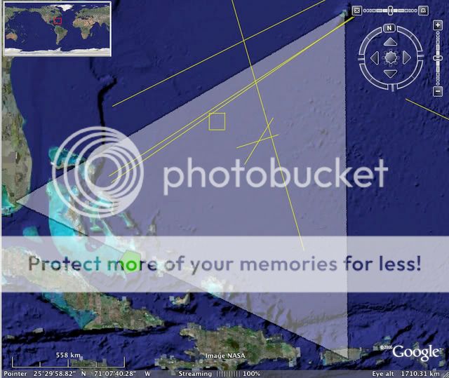
I've highlighted the trench "scars" in yellow. The white trianle is the "Bermuda Triangle." Notice that a couple trenches form an "X" nearly in the center of this. Also, check out the square formation near the north side of the triangle. This is more likely a ridge than a trench, but thought it was notable. Also, the pentagon that you highlight (in green) is just barely with in the triangle's boundries.
Anyway, while we're on the subject, I've always been fascinated with the "scars" that the Earth has underneath it's oceans. Many of these "scars" are trenches. I find it extremely odd that these trenches run in straight lines:
I've highlighted the trench "scars" in yellow. The white trianle is the "Bermuda Triangle." Notice that a couple trenches form an "X" nearly in the center of this. Also, check out the square formation near the north side of the triangle. This is more likely a ridge than a trench, but thought it was notable. Also, the pentagon that you highlight (in green) is just barely with in the triangle's boundries.
I gotta say, it seems like you guys are reaching pretty far here with this one. a Pentagon ? ... looks more like a rigid circle, pentagon is pushing
it.
Not saying you're dreaming, im just saying its a stretch. I'll still read up on it a bit.
Not saying you're dreaming, im just saying its a stretch. I'll still read up on it a bit.
reply to post by mortalengine
well, I think it depends on what you're looking at:
If you're looking at the color imaging of the ocean, you'll see a circle:

If you look at the elevational depth, you'll see a pentagon:

well, I think it depends on what you're looking at:
If you're looking at the color imaging of the ocean, you'll see a circle:
If you look at the elevational depth, you'll see a pentagon:
Call me crazy but that looks like a airport or something.
The pentagon is an amazing find. I wonder if that area has ever been excavated or if artifacts have been found around there.
new topics
-
President BIDEN's FBI Raided Donald Trump's Florida Home for OBAMA-NORTH KOREA Documents.
Political Conspiracies: 1 hours ago -
Maestro Benedetto
Literature: 3 hours ago -
Is AI Better Than the Hollywood Elite?
Movies: 3 hours ago -
Las Vegas UFO Spotting Teen Traumatized by Demon Creature in Backyard
Aliens and UFOs: 6 hours ago -
2024 Pigeon Forge Rod Run - On the Strip (Video made for you)
Automotive Discussion: 7 hours ago -
Gaza Terrorists Attack US Humanitarian Pier During Construction
Middle East Issues: 8 hours ago -
The functionality of boldening and italics is clunky and no post char limit warning?
ATS Freshman's Forum: 9 hours ago -
Meadows, Giuliani Among 11 Indicted in Arizona in Latest 2020 Election Subversion Case
Mainstream News: 9 hours ago -
Massachusetts Drag Queen Leads Young Kids in Free Palestine Chant
Social Issues and Civil Unrest: 10 hours ago -
Weinstein's conviction overturned
Mainstream News: 11 hours ago
top topics
-
President BIDEN's FBI Raided Donald Trump's Florida Home for OBAMA-NORTH KOREA Documents.
Political Conspiracies: 1 hours ago, 13 flags -
Krystalnacht on today's most elite Universities?
Social Issues and Civil Unrest: 12 hours ago, 9 flags -
University of Texas Instantly Shuts Down Anti Israel Protests
Education and Media: 15 hours ago, 8 flags -
Supreme Court Oral Arguments 4.25.2024 - Are PRESIDENTS IMMUNE From Later Being Prosecuted.
Above Politics: 12 hours ago, 8 flags -
Gaza Terrorists Attack US Humanitarian Pier During Construction
Middle East Issues: 8 hours ago, 7 flags -
Weinstein's conviction overturned
Mainstream News: 11 hours ago, 7 flags -
Massachusetts Drag Queen Leads Young Kids in Free Palestine Chant
Social Issues and Civil Unrest: 10 hours ago, 7 flags -
Meadows, Giuliani Among 11 Indicted in Arizona in Latest 2020 Election Subversion Case
Mainstream News: 9 hours ago, 5 flags -
Las Vegas UFO Spotting Teen Traumatized by Demon Creature in Backyard
Aliens and UFOs: 6 hours ago, 4 flags -
2024 Pigeon Forge Rod Run - On the Strip (Video made for you)
Automotive Discussion: 7 hours ago, 3 flags
active topics
-
Sol Et Luna - TIME2024
Short Stories • 10 • : BrotherKinsMan -
University of Texas Instantly Shuts Down Anti Israel Protests
Education and Media • 263 • : cherokeetroy -
Is AI Better Than the Hollywood Elite?
Movies • 9 • : 5thHead -
Massachusetts Drag Queen Leads Young Kids in Free Palestine Chant
Social Issues and Civil Unrest • 13 • : ToneD -
Gaza Terrorists Attack US Humanitarian Pier During Construction
Middle East Issues • 26 • : nugget1 -
British TV Presenter Refuses To Use Guest's Preferred Pronouns
Education and Media • 168 • : Annee -
Manly P. Hall says Freemasonry is a religion?
Secret Societies • 22 • : Therealbeverage -
One Flame Throwing Robot Dog for Christmas Please!
Weaponry • 11 • : Therealbeverage -
HORRIBLE !! Russian Soldier Drinking Own Urine To Survive In Battle
World War Three • 48 • : Therealbeverage -
The Good News According to Jesus - Episode 1
Religion, Faith, And Theology • 3 • : Therealbeverage