It looks like you're using an Ad Blocker.
Please white-list or disable AboveTopSecret.com in your ad-blocking tool.
Thank you.
Some features of ATS will be disabled while you continue to use an ad-blocker.

California Concentration Camp/Facilities
page: 2share:
Originally posted by dave_54
Why has no one questioned why NASA maintains an office at a remote forest ranger station near Quincy, CA?
It appears to be a station that measures plate motion/earth rotation. Or... maybe they just send NASA employees who've been naughty there
NASA QUINCY SITE
cddis.nasa.gov...
dave_54,
NASA doesn't have a "secret" facility at Quincy, California. It is part of the NASA Jet Propulsion Laboratory's involvement in the Crustal Dynamics Data Information System. This involves research into the deformation (movement) of tectonic plates using data from Global Positioning System (GPS) stations. The Quincy site is part of the Bay Area Regional Deformation Network (BARD), a set of permanent GPS receiver stations.
The primary goal of the network is to monitor crustal deformation across the Pacific-North America plate boundary and in the San Francisco Bay Area for earthquake hazard reduction studies and rapid earthquake emergency response assessment.
Check out these links for more information:
www.ncedc.org...
cddis.gsfc.nasa.gov...
Originally posted by Shadowhawk
dave_54,
NASA doesn't have a "secret" facility at Quincy, California. It is part of the NASA Jet Propulsion Laboratory's involvement in the Crustal Dynamics Data Information System. This involves research into the deformation (movement) of tectonic plates using data from Global Positioning System (GPS) stations. The Quincy site is part of the Bay Area Regional Deformation Network (BARD), a set of permanent GPS receiver stations.
The primary goal of the network is to monitor crustal deformation across the Pacific-North America plate boundary and in the San Francisco Bay Area for earthquake hazard reduction studies and rapid earthquake emergency response assessment....
That's a rather transparent cover story.
I'm not sure what you mean by "cover story, dave_54. It's not a cover story for anything. It's just part of NASA's mission to study Earth's
environment.
Personally, I like Secret San Jose's suggestion that naughty NASA employees might get banished to Quincy, California. In my experience, however, NASA employees who screw up badly enough get banished to Hawaii. Go figure.
Personally, I like Secret San Jose's suggestion that naughty NASA employees might get banished to Quincy, California. In my experience, however, NASA employees who screw up badly enough get banished to Hawaii. Go figure.
SHADOWHAWK : the " obvious " answer would be that Hawaii , despite its famed sun , surf and hawt chicks - is a NASA carreer dead end .
people , as a rule do not join NASA for sun , surf and chicks
people , as a rule do not join NASA for sun , surf and chicks
Originally posted by Lorraine
I have a list of California concentration camps. I don't know how reliable this list is, but I will post what I have so that you can check out those that may be close to you. It would be great if someone could verify some of these.
Vandenburg AFB - Rex 84 facility, located near Lompoc & Santa Maria. Internment facility is located near the oceanside, close to Space Launch Complex #6, also called "Slick Six". The launch site has a flawless failure record and is rarely used.
Norton AFB - (closed base) now staffed with UN according to some sources.
Tule Lake - area of "wildlife refuge", accessible by unpaved road, just inside Modoc County. Fort Ord - Closed in 1994, this facility is now an urban warfare training center for US and foreign troops, and may have some "P.O.W. - C.I." enclosures.
Twentynine Palms Marine Base - Birthplace of the infamous "Would you shoot American citizens?" Quiz. New camps being built on "back 40".
Oakdale - Rex 84 camp capable of holding at least 20,000 people. 90 mi. East of San Francisco.
Terminal Island - (Long Beach) located next to naval shipyards operated by ChiCom shipping interests. Federal prison facility located here. Possible deportation point.
Ft. Irwin - FEMA facility near Barstow. Base is designated inactive but has staffed camp.
Manzanar - Inyo County WWII Japanese detention camp. Ready for possible renovation.
McClellan AFB - facility equipped for 30,000 - 35,000 Sacramento - Army Depot - No specific information at this time.
Mather AFB - Road to facility is blocked off by cement barriers and a stop sign. Sign states area is restricted; as of 1997 there were barbed wire fences pointing inward, a row of stadium lights pointed toward an empty field, etc. Black boxes on poles may have been cameras.
Lorraine
The Terminal Island Detention Center is not a secret by any stretch.
It is a prison that is used by US Customs to detain illegal immigrants prior to deportation. I work near there, and it is not a secret at all, there's road signs for it even. It isn't that big though.
I know it's hard to believe, but on occasion the US govt does actually kick out illegal immigrants.
I live about 5 miles from concentration camp #5, the one in Glendale, so I decided to go see for myself. I followed the directions and, sure enough,
there was a fenced area with barbed wire. The thing is, the enclosed area had no buildings. It was just an obsolete reservoir. I would guess the
reason for the barbed wire is that there are a couple of steep drops and they want keep kids out. And no, there weren't any armed guards around.
There was another structure I could see up above so I went up there and found an actual operating reservoir. It too had barbed wire around it. And still no armed guards. I guess if they were taking the day off, they figured a couple of wooden shutter-type doors with padlocks were sufficient to keep the riff-raff out (or in).
In reality, these structures lie right next to a hiking trail and you can walk right next to it or hike above it and see everything in it down below. Whoever reported this as a concentration camp is probably having a good chuckle.
I have a friend who has an off road shop in Pearblossom,so it must be one of 3 buildings you mentioned,I think theres 3 buildings in town,I've never
seen any detention center there,maybe your thinking of Boron which is a regular prison
Originally posted by glan
OF COURSE I WILL POST ALL PICTURES THAT I TAKE.
1. PEARBLOSSOM, CALIFORNIA: Located at the intersection of Ave 116 and
the Pearblossom Highway, this is a full-service facility, complete with gas
chambers, moat, machine gun towers, and roving armed patrols. Visit at
your own risk. If you do decide to see this one, you will be descended upon by
some very mean fellows, who will get your ID and license, then monitor
you.
first thing's first, i'll show you mine if you show me yours:
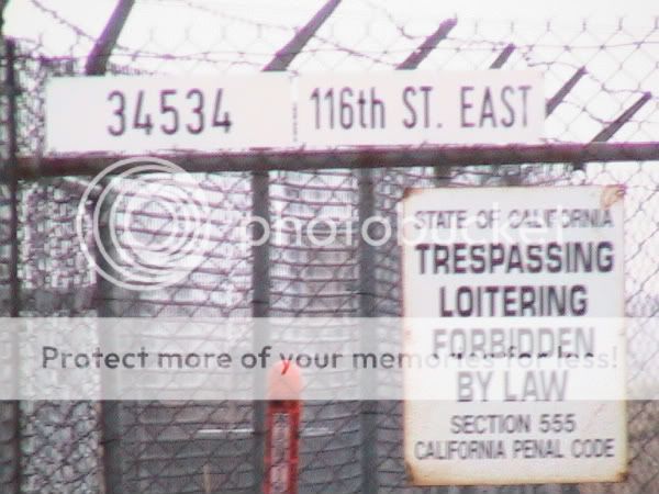
now that that's settled, there isn't a single machine gun tower, nor were there "roving armed patrols". i would know because i actually went to this location, took a picture and am now sharing this information with the ill-informed and/or paranoid.
we didn't get tailed. infact, no one seemed to care that some random car had pulled up, taken a picture and drove off. i recently visited this site and took the picture, so um.. yeah.
not to say there isn't a possibility of secret detention centers, but atleast show some proof before spouting off and scaring the bejesus out of the readers of this thread.
[edit on 25-5-2008 by die bunker]
[edit on 25-5-2008 by die bunker]
reply to post by glan
First off, I think FEMA is a dangerous arm of our government and needs major overhauling, but with that said:
The resivoir at Brand Park in Glendale California can be spotted using Google Maps or Google Earth. You can walk right up to it via the "fire road" or on the groomed and maintained trails. Its right in the middle of a public park. It's just a freakin resevoir...no bad guys with guns, no no-trespassing signs, no video surveilence, no concentration camp, no conspiracy.
Ive walked/biked about every square inch of Fort Ord near Monterey Ca [ I live in Marina Ca ] and I can say there is absolutly nothing even close to a
concentration, POW camp or underground bunker there.
Even out in whats commonly refered to as "The City" where the FBI and other agencies do alot of urban warfare training there isnt anything like that. Its actually a pretty small area that is easilly seen on Google earth.
Just thought I would toss this in since I have seen Fort Ord refered to as a possabillity for all of the above.
There is an old stockade that looks like a very small prison but its been closed down for several years even before the base closed. Its actually a small cement mixing plant now that sits right on the CSUMB campus
You can walk around in it and there are a few sites [ just Google it ] that have tons of Fort Ord stockade and base pics since its closure.
Also the one in Valencia Ca is probably the Pitchess Detention Center [ located in the area mentioned ] which is a sprawling complex of several Jails and work farms for LA County. Again its easilly seen with Google Earth and definitly not a secret.
[edit on 24-9-2008 by Candycab]
reply to post by Silver Eagle
Does anyone have some information on the Oakdale facility? All the information online just posts the same information, that it's off Highway 120 in Oakdale, 90 miles east of san francisco, and it can house 15000-20000 people. But where along 120, or in Oakdale, is it, exactly. Looking on Google Earth, I didn't find any obvious candidates.
Does anyone have some information on the Oakdale facility? All the information online just posts the same information, that it's off Highway 120 in Oakdale, 90 miles east of san francisco, and it can house 15000-20000 people. But where along 120, or in Oakdale, is it, exactly. Looking on Google Earth, I didn't find any obvious candidates.
Originally posted by glan
He
4. VALENCIA, CALIFORNIA: This is one of the largest camps ever
constructed and measures some two miles by three miles, using the reservoir at
the intersection of the 5 and 405 freeways as a cover. New buildings, armed
guards, new roads, and many hundreds of buildings for housing the damned.
I drive by this "camp" twice a day. It is the site of the old Van Norman Lakes in Granada Hills. Site was vacated after the January 1971 Sylmar Earthquake.
This facility is part of the Los Angeles Dept of Water and Power and is leased the the Los Angeles Police Department for their officer driver "training" course. There are buildings on the property, but they have been there quite a while and sit at the eastern edge of the facility.
The only signs that this may be used as a holding area is the barbed-wire extension, on the of the chain link fence, point to the inside, to keep people from getting out.
This is the only change I have seen in the last 15 years. No new roads, no guards, towers, railcars or railspurs, plastic coffins, or anything out of the usual. It sits in a basin caused when the lakes were emptied, with high ground surrounding the facility. Not an area I prefer to defend if I had to. Old likes the high ground.
So I have my doubts, but then you never know what the PTB have on their minds.
reply to post by Anonymous ATS
I live 10 miles from the supposed Oakdale facility in California. I drive through Oakdale many times throughout the year. I have never seen anything that might resemble a camp. If anyone has any leads as to the exact location of this one I will be more than happy to go out there and shoot some video. Either way, I am going out there today and do some scouting and see if I can come up with anything. I will be bringing my video camera in case I do see something. I do know that the Hershey plant recently closed and laid off 600 employess. I know the number is far off from the 15,000-20,000 that this camp is suppose to be capable of holding, but the size of the property/land seems possible to accommodate that number. Again, if I come accross anything you will be hearing from me again.
Peace be with us,
rhuomai
www.uaff.us...
Vandenburg AFB - Rex 84 facility, located near Lompoc & Santa Maria. Internment facility is located near the oceanside, close to Space Launch Complex #6, also called "Slick Six". The launch site has had "a flawless failure record" and is rarely used. Norton AFB - (closed base) now staffed with UN according to some sources. Tule Lake - area of "wildlife refuge", accessible by unpaved road, just inside Modoc County. Fort Ord - Closed in 1994, this facility is now an urban warfare training center for US and foreign troops, and may have some "P.O.W. - C.I." enclosures. Twentynine Palms Marine Base - Birthplace of the infamous "Would you shoot American citizens?" Quiz. New camps being built on "back 40". Oakdale - Rex 84 camp capable of holding at least 20,000 people. 90 mi. East of San Francisco. Terminal Island - (Long Beach) located next to naval shipyards operated by ChiCom shipping interests. Federal prison facility located here. Possible deportation point. Ft. Irwin - FEMA facility near Barstow. Base is designated inactive but has staffed camp. McClellan AFB - facility capable for 30,000 - 35,000 Sacramento - Army Depot - No specific information at this time. Mather AFB - Road to facility is blocked off by cement barriers and a stop sign. Sign states area is restricted; as of 1997 there were barbed wire fences pointing inward, a row of stadium lights pointed toward an empty field, etc. Black boxes on poles may have been cameras
this is an excellent site with all aspects of nwo/nau compartmentalized
I just thought I would add my few cents along with some questions. I live in Northern Ca. I have worked up at Boreal in the winters for the last ten
years. For those of you that don't know Boreal is a ski resort up I 80 about 10 miles from truckee heading east bound. Now randomly over the years we
would get low flying military aircraft fly right over us. most common seemed to be those helicopters that are longer that have two big sets of blades
on the top in the front and back of the copter, I am sure you know which I am talking about sorry I am not more knowleged here. We would also see some
type of fighter jets from time to time.
Now this last season there was a very noticable increase in air activity. What most surprised me was that twice this last season I saw I large grey military plane, almost the size of commercial airliner litterally buzz the peak of our mountain. Both times I saw this it seemed as if the plane must be going down because half the plane wasn't even visable as it was hidden by the mountain but the plane was so big it had to be pretty close I would honestly guess less than 50 feet from the ground. Both times I saw this was on busy weekend days so thousands of people had to have seen it. Also I am one of the people at Boreal who always has a walkie talkie radio and we have our own private network. This season we would constatly get interference on them which to all of us sounded like military talk and it happened more so durring the days where there was a lot of military fly over happening. Now all the activitly seemed to come from behind Boreal which leads toward Tahoe and beyond and down towards the Blue Canyon area which I have heard many strange stories from growing up about strange lights and humms and such. Usually when we see these planes they seem to be going down as if they are landing somewhere close out there in those valleys but we can never tell for sure. So my question is if anyone knows where this activity could be coming from. And to help narrow down military activity in northern ca. for the thread.
[edit on 6-10-2008 by 1Veritas]
Go to Google Earth, Pointer coordinates-34º 11'03.2º n 118º 12'52.54º
This is located in a basin off the 2 freeway between the Mountain Street exit and the 210 freeway in Glendale, CA. The white area next to the freeway now has a steel structure
with triple razor wire and tower lights around it. Around the ball fields are now surrounded high fences topped by razor wire and tower lights as well. There are is only one road in and the whole thing is encircled on three sides by high, steep hills. I suggest you see this for yourself and you be the judge. This isn't like the "Dr. House" at Brand Park which is easily accessible and looks like ant other wash in So-Cal.
What's really scary is it's disguised as a kids baseball field.
reply to post by Anonymous ATS
You are kidding, right? I've played ball on those fields, they are just a bunch of ball fields lit up for night use and, kind of a biggie, located right NEXT TO THE GLENDALE 2 FREEWAY!!! Why would they build one of these super secret camps next to and visible from a freeway that gets hundred of thousands of commuters going by every day? Come on.
You are kidding, right? I've played ball on those fields, they are just a bunch of ball fields lit up for night use and, kind of a biggie, located right NEXT TO THE GLENDALE 2 FREEWAY!!! Why would they build one of these super secret camps next to and visible from a freeway that gets hundred of thousands of commuters going by every day? Come on.
reply to post by Anonymous ATS
Not likely. This is a baseball field complex I've been to many times. Plus, it is RIGHT NEXT TO A FREEWAY and clearly visible to thousands of cars driving past it every day. Not a smart place for a 'secret' camp. Try again please. Cheers.
Not likely. This is a baseball field complex I've been to many times. Plus, it is RIGHT NEXT TO A FREEWAY and clearly visible to thousands of cars driving past it every day. Not a smart place for a 'secret' camp. Try again please. Cheers.
new topics
-
Pelosi injured in Luxembourg
Other Current Events: 3 hours ago -
Nov 2024 - Former President Barack Hussein Obama Has Lost His Aura.
US Political Madness: 4 hours ago -
Something better
Dissecting Disinformation: 9 hours ago
top topics
-
They Know
Aliens and UFOs: 17 hours ago, 18 flags -
Pelosi injured in Luxembourg
Other Current Events: 3 hours ago, 10 flags -
Something better
Dissecting Disinformation: 9 hours ago, 8 flags -
Nov 2024 - Former President Barack Hussein Obama Has Lost His Aura.
US Political Madness: 4 hours ago, 7 flags -
More Ons?
Political Conspiracies: 13 hours ago, 6 flags -
Friday thoughts
General Chit Chat: 13 hours ago, 5 flags -
Canada Post strike ended by the Government of Canada
Mainstream News: 13 hours ago, 4 flags -
The Witcher IV — Cinematic Reveal Trailer | The Game Awards 2024
Video Games: 12 hours ago, 3 flags
active topics
-
-@TH3WH17ERABB17- -Q- ---TIME TO SHOW THE WORLD--- -Part- --44--
Dissecting Disinformation • 3672 • : duncanagain -
Top Sci Fi/Horror Crossover Movies
Movies • 13 • : worldstarcountry -
Post A Funny (T&C Friendly) Pic Part IV: The LOL awakens!
General Chit Chat • 7907 • : KrustyKrab -
They Know
Aliens and UFOs • 71 • : donfreas -
Drones everywhere in New Jersey
Aliens and UFOs • 112 • : worldstarcountry -
Pelosi injured in Luxembourg
Other Current Events • 15 • : NorthOS -
Something better
Dissecting Disinformation • 17 • : AlroyFarms -
A Bunch of Maybe Drones Just Flew Across Hillsborough County
Aircraft Projects • 72 • : worldstarcountry -
President Biden to Grant Blanket Pardons to Individuals Trump's DOJ May Indict 2025-2029.
US Political Madness • 47 • : WeMustCare -
Drones (QUESTION) TERMINATOR (QUESTION)
General Chit Chat • 11 • : Cavemannick