It looks like you're using an Ad Blocker.
Please white-list or disable AboveTopSecret.com in your ad-blocking tool.
Thank you.
Some features of ATS will be disabled while you continue to use an ad-blocker.

Just What Does Google Think They're Hiding?
page: 2share:
I am quite confident that someone within the circle of powers to be is to be behind the censored photos. What I find weird is that from the first pic.
the W/H and the two other buildings off to each side are blotted out but yet the other pics. depict snipers on the roof of the W/H. Perhaps they have
a new type of weapons systems deployed up there and do not want the general pouplation to know just what it is. This would be good to have
explained.
That is interesting, I didn't know about it before. It's weird you can find the other images you posted on the same site showing the people on the
roof. I'm not sure how hard it was to find the other pics, but maybe they assume most people looking on their won't know how to find the other
pics.
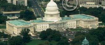
I took a look at the United States Capitol, not far from the White House. This is a building that is recognized by almost everyone in the world and
has been photographed from every conceivable angle.
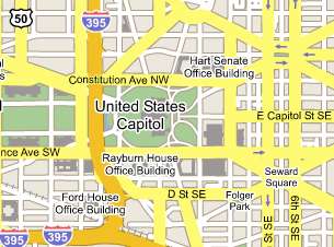
It's location is very well known:
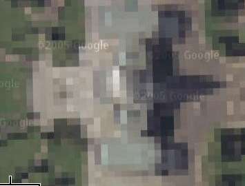
Now I zoom in for a closer look and the fuzzy pixels show up:
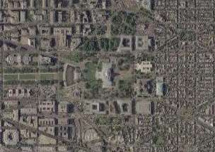
But if I pan to the front of the building you can see clearly:
I guess my original question still stands. What does Google Maps think they are hiding??? And who is telling them to do this???
Anybody can get pictures of the Capitol Building, it's not exactly a national secret. Hell, you can walk right up to this amazing structure.
It's location is very well known:
Now I zoom in for a closer look and the fuzzy pixels show up:
But if I pan to the front of the building you can see clearly:
I guess my original question still stands. What does Google Maps think they are hiding??? And who is telling them to do this???
Anybody can get pictures of the Capitol Building, it's not exactly a national secret. Hell, you can walk right up to this amazing structure.
google research of my own...
Time-Warner own thousands of dollars worth of google stock. And they are also deeply connected to president Bush.

President George W. Bush listens to Time Warner CEO Richard Parsons, center, during a White House economic conference at the Ronald Reagan Building and International Trade Center in Washington, D.C.,
Link
Interesting to note that Gore was funded by Time-Warner during the electoral campaign and not Bush.
Link
So is it safe to say that Bush's own hand is behind this masking of the buildings. And if so, WHY?
Time-Warner own thousands of dollars worth of google stock. And they are also deeply connected to president Bush.
President George W. Bush listens to Time Warner CEO Richard Parsons, center, during a White House economic conference at the Ronald Reagan Building and International Trade Center in Washington, D.C.,
Link
Interesting to note that Gore was funded by Time-Warner during the electoral campaign and not Bush.
Gores media money comes mostly from the larger media conglomerates, such as Disney, Time Warner and Viacom Inc.;
Link
So is it safe to say that Bush's own hand is behind this masking of the buildings. And if so, WHY?
The message was:
If I get a reply from them I'll post the answer in this thread.
Very interesting take on the subject Yossarian. The two links you provided return the message posted below. Hope you can fix them, I'd like to take a look. In my own research, I'm finding it very hard to find just what Time-Warner owns or who owns Google stock. Hmmmmmm....

[edit on 25/10/2005 by anxietydisorder]
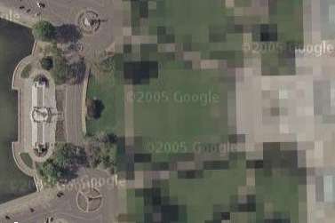
I was looking at landmarks around the Washington DC area with Google Maps when I noticed that the White House, Treasury Department, Old Executive Office Building and the Capitol Building all have a mask over them. In the case of the Capitol Building there is pixels over the structure so that it can't be seen properly.
I was wondering why this was and who decided that these building should be hidden???
When looking at the White House with Google Earth, there is no mask in place. So what's the deal???
Thank-you in advance, I hope you can answer my question without having to kill me after in the name of national security. lol
If I get a reply from them I'll post the answer in this thread.
Very interesting take on the subject Yossarian. The two links you provided return the message posted below. Hope you can fix them, I'd like to take a look. In my own research, I'm finding it very hard to find just what Time-Warner owns or who owns Google stock. Hmmmmmm....
[edit on 25/10/2005 by anxietydisorder]
My guess is..that its because the google map rendering can be cut, pasted, georeferenced and "rubbersheeted" into a GIS program capable of
navigating. I have done that before using the old drawn maps of my area. We use ESRI's ARC GIS desktop and can add an image (raster) or even a CAD
file, overlay and associate a few common corners on a previously referenced dataset and bingo, it slides right into place and now has vector data
assigned to any object because it lays on the same "tick" as the original data.
In other words, now each place you click, you have coordinates and depending on how accurate they are you could zero in on a sub-meter accuracy. Enter those into even a discount store GPS unit and it will guide you within 100 feet. Enter it into a Trimble GPS and you could be within six feet.
Evidentially, there is something about the google maps that make them more susceptible to this practice than images from google earth. It could deal with the law at the time of release as well.
www.whitehouse.gov...
google.blognewschannel.com...
www.rankforsales.com...
Here are 3 links I came across on google with reference to Time-Warner and Google.
google.blognewschannel.com...
www.rankforsales.com...
Here are 3 links I came across on google with reference to Time-Warner and Google.
This thread has cost me far more points to construct than I'll ever earn back from responses.
You do the math.........
www.abovetopsecret.com...
You do the math.........
www.abovetopsecret.com...
Originally posted by astroblade
i don't know what your malfunction is, but i just pulled up google earth and this was the image of the white house...
as you can see, nothing is concealed, and all is seen. stop jumping to conclusions.
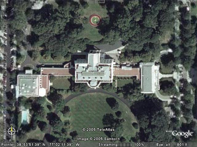
Does Google Earth use aerial snapshots from a plane or Satellite photos? I just thought the image looked odd on the north side of the building in the center. You can see the sides of the walls on parts of the building. Some parts you cannot.
I'm no expert in this type of thing but if you're looking straight down at something you shouldn't be able to see the sides of the walls on parts of the building.
Or maybe it's some kind of illusion to my eyes?
Hi,
I'm new to ATS, so I don't want my first post to get off topic, but if you go to google.com and enter "failure" in the search box and hit "I'm feeling lucky" you'll get directed to an interesting web-site. I'm sure many of you have seen this before.
Does anyone know how this was set up, or if it had to be someone working for google behind it? It's kinda funny, but it may also decrease the chances of Bush having control or influence over goolge.
[edit on 27-10-2005 by DeuceCyrenne]
The page ranking was rigged by pranksters, Google received complaints but they won't alter the results.
Here's the link for the Googlebombing 'failure' explanation:
googleblog.blogspot.com...
From same website, they mention that the photoshopped White House came from Keyhole, so apparently Google are not the one responsible for this censored image.
googleblog.blogspot.com...
Still no explanation who requested the image to be censored and why?
maps.google.com...,-59.845791&spn=5.469784,9.622925&t=h&hl=en
What is this? Is it like a sea wall or some kind of tunnel or what? I've been looking for information, but alas, none is to be found.
I don't think it's part of Canada. It doesn't look natural either. You can't zoom in that close to it.
[edit on 10/27/2005 by blackstar]
What is this? Is it like a sea wall or some kind of tunnel or what? I've been looking for information, but alas, none is to be found.
I don't think it's part of Canada. It doesn't look natural either. You can't zoom in that close to it.
[edit on 10/27/2005 by blackstar]
Originally posted by anxietydisorder
The message was:
I was looking at landmarks around the Washington DC area with Google Maps when I noticed that the White House, Treasury Department, Old Executive Office Building and the Capitol Building all have a mask over them. In the case of the Capitol Building there is pixels over the structure so that it can't be seen properly.
I was wondering why this was and who decided that these building should be hidden???
When looking at the White House with Google Earth, there is no mask in place. So what's the deal???
Thank-you in advance, I hope you can answer my question without having to kill me after in the name of national security. lol
If I get a reply from them I'll post the answer in this thread.
It took a while, but Google has responded to the e-mail that I sent.
Hello,
The imagery was provided to us in that format and resolution. Moving
forward we are hoping to integrate the Google Earth imagery into Google
Local so that each product displays similar imagery.
Please continue to enjoy our program, and let us know if we can assist you
further.
Thank you for using Google Earth,
The Google Earth Support Team
Now I wonder who provided the imagery and who made the choice to mask out some buildings???? Hmmmmmm.......
Originally posted by Implosion
I find it interesting that the two buildings flanking the white house look like the number 8. H is the 8th number of the alphabet, many far right groups using 88=HH=Heil Hitler.
Not that I think that there is anything in this, but you know, fits in with the swastika buildings, and that is what made me think of it. I guess what it really shows is that you can find meaning in everything if you try hard enough.
To answer your original question, I have no idea
Surely no one could get near enough to the place to use whatever information they got from google? Maybe there was a "sports model" parked up on the secret roof landing pad at the time.
[edit on 24-10-2005 by Implosion]
Wow, I didn't notice that-good eye for detail...scary detail but detail none the less
I find this thread very intresting, it makes you wonder who has done this and what other pictures they have doctord or ''coverd-up''(parden the
pun).
I hope we can get some answers soon. I will try to look for some here in the uk.
I hope we can get some answers soon. I will try to look for some here in the uk.
You think thats worrying?
You can actually see portsmouth naval base...which btw is the home port for the entire surface fleet of the RN....not exsactly smart..
On the other hand they have blacked out almost all of faslane....except for the shooting ranges lol that I noticed..
You can actually see portsmouth naval base...which btw is the home port for the entire surface fleet of the RN....not exsactly smart..
On the other hand they have blacked out almost all of faslane....except for the shooting ranges lol that I noticed..
More than likely, it was a Top Secret, No-Go Zone, at one time. Think about it, if the terrorists flying the planes on Sept 11th knew what the top of
the White house looked like exactly, they might have been able to target it better.
No clue, but just a simple suggestion.
No clue, but just a simple suggestion.
new topics
-
BIDEN Admin Begins Planning For January 2025 Transition to a New President - Today is 4.26.2024.
2024 Elections: 1 hours ago -
Big Storms
Fragile Earth: 2 hours ago -
Where should Trump hold his next rally
2024 Elections: 5 hours ago -
Shocking Number of Voters are Open to Committing Election Fraud
US Political Madness: 5 hours ago -
Gov Kristi Noem Shot and Killed "Less Than Worthless Dog" and a 'Smelly Goat
2024 Elections: 6 hours ago -
Falkville Robot-Man
Aliens and UFOs: 6 hours ago -
James O’Keefe: I have evidence that exposes the CIA, and it’s on camera.
Whistle Blowers and Leaked Documents: 7 hours ago -
Australian PM says the quiet part out loud - "free speech is a threat to democratic dicourse"...?!
New World Order: 8 hours ago -
Ireland VS Globalists
Social Issues and Civil Unrest: 8 hours ago -
Biden "Happy To Debate Trump"
2024 Elections: 9 hours ago
top topics
-
James O’Keefe: I have evidence that exposes the CIA, and it’s on camera.
Whistle Blowers and Leaked Documents: 7 hours ago, 14 flags -
Australian PM says the quiet part out loud - "free speech is a threat to democratic dicourse"...?!
New World Order: 8 hours ago, 13 flags -
Blast from the past: ATS Review Podcast, 2006: With All Three Amigos
Member PODcasts: 11 hours ago, 13 flags -
Biden "Happy To Debate Trump"
2024 Elections: 9 hours ago, 12 flags -
Mike Pinder The Moody Blues R.I.P.
Music: 11 hours ago, 8 flags -
What is the white pill?
Philosophy and Metaphysics: 11 hours ago, 6 flags -
Shocking Number of Voters are Open to Committing Election Fraud
US Political Madness: 5 hours ago, 6 flags -
RAAF airbase in Roswell, New Mexico is on fire
Aliens and UFOs: 9 hours ago, 5 flags -
Ireland VS Globalists
Social Issues and Civil Unrest: 8 hours ago, 5 flags -
Where should Trump hold his next rally
2024 Elections: 5 hours ago, 5 flags
active topics
-
BIDEN Admin Begins Planning For January 2025 Transition to a New President - Today is 4.26.2024.
2024 Elections • 6 • : BingoMcGoof -
President BIDEN's FBI Raided Donald Trump's Florida Home for OBAMA-NORTH KOREA Documents.
Political Conspiracies • 37 • : SchrodingersRat -
Mood Music Part VI
Music • 3112 • : underpass61 -
Big Storms
Fragile Earth • 10 • : AwakeNotWoke -
James O’Keefe: I have evidence that exposes the CIA, and it’s on camera.
Whistle Blowers and Leaked Documents • 12 • : pianopraze -
Australian PM says the quiet part out loud - "free speech is a threat to democratic dicourse"...?!
New World Order • 6 • : Scratchpost -
"We're All Hamas" Heard at Columbia University Protests
Social Issues and Civil Unrest • 297 • : TheWoker -
Where should Trump hold his next rally
2024 Elections • 18 • : TheMisguidedAngel -
Krystalnacht on today's most elite Universities?
Social Issues and Civil Unrest • 15 • : marg6043 -
-@TH3WH17ERABB17- -Q- ---TIME TO SHOW THE WORLD--- -Part- --44--
Dissecting Disinformation • 702 • : Crazierfox