It looks like you're using an Ad Blocker.
Please white-list or disable AboveTopSecret.com in your ad-blocking tool.
Thank you.
Some features of ATS will be disabled while you continue to use an ad-blocker.

Last Glacial Maximum. Why are the glaciers not centered on the North Pole?
page: 1share:
Look at a top down map of the Northern glaciers during the last ice age. Do you notice anything strange?
www.qpg.geog.cam.ac.uk...
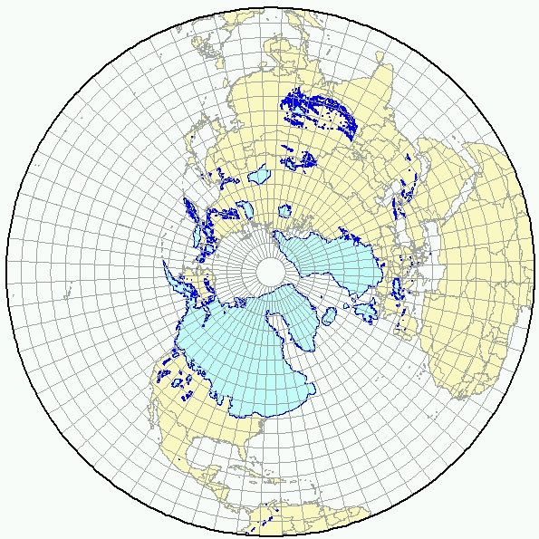
It looks to me like the glaciers are kind of lopsided. Definitely not centered on the Pole. Siberia and Alaska look like they were mostly spared.
And we can't know how far the ice extended out into the ocean. It's only possible to definitively say with certainty where glaciers left their footprint on land (and where they didn't.)
So... I'm curious: what archaeological law forbids us to simply take these maps at face value, and assume the North pole was simply not located where it is today? Why would it not simply be where the poles always are: right in the smack middle of all the ice?
If we need an explanation for a pole shift, there's a growing likelihood that Northern Greenland got hit with a very large meteor (11 to 12 billion ton, 0.75 mile wide) sometime in the last 100,000 years, with the Younger Dryas event ~13,000 years ago being a likely candidate for that.
www.sciencemag.org...
Alone, the meteor wouldn't be big enough to move anything probably. Because although 11 billion tons, or 11 trillion kg is a lot, the Earth's mass is about 6 trillion trillion kg. (Yes, I said "trillion" twice. It's a 6 with 24 zeros after it.) Not even a comparison.
However, there is always a very small wobble in the Earth's axis of rotation. The Chandler Wobble. It's very small, but it goes to show the axis isn't as stable as we might like to think.
en.wikipedia.org...
Probably a lot of ice would have melted very suddenly, which adds to the mass displacement. The water would take some time to redistribute, like probably a good share of a day at least.
For example, the Tsunami that caused the Fukushima disaster in Japan was estimated to take between 10 and 30 minutes to traverse the 67 kilometers from where it originated, to the coast of Japan.
en.wikipedia.org...
So a giant swell, flow, or tidal wave on the scale of the Haiawatha impact could take a good while to get completely smoothed out.
On the grand scale, it wouldn't change astronomy much. The North star would still be located at the new North. (I think it was Draco back then.) Even the 12 signs of the Zodiac remain the same once you adjusted for the new orientations. The reason being because the Moon still orbits at the same off angle it always has, forcing the rotation to resume being oriented to it.
The best way to visualize would be to take a ball and set it on top of water. Then start it spinning. If you just tap it, you find it really doesn't take much to change the orientation of its spin. Like if you mark in black where the axis was originally (like what axis you chose to spin it on). You might find the axis it ends up on after you perturb it is another one entirely.
www.qpg.geog.cam.ac.uk...
It looks to me like the glaciers are kind of lopsided. Definitely not centered on the Pole. Siberia and Alaska look like they were mostly spared.
And we can't know how far the ice extended out into the ocean. It's only possible to definitively say with certainty where glaciers left their footprint on land (and where they didn't.)
So... I'm curious: what archaeological law forbids us to simply take these maps at face value, and assume the North pole was simply not located where it is today? Why would it not simply be where the poles always are: right in the smack middle of all the ice?
If we need an explanation for a pole shift, there's a growing likelihood that Northern Greenland got hit with a very large meteor (11 to 12 billion ton, 0.75 mile wide) sometime in the last 100,000 years, with the Younger Dryas event ~13,000 years ago being a likely candidate for that.
www.sciencemag.org...
Alone, the meteor wouldn't be big enough to move anything probably. Because although 11 billion tons, or 11 trillion kg is a lot, the Earth's mass is about 6 trillion trillion kg. (Yes, I said "trillion" twice. It's a 6 with 24 zeros after it.) Not even a comparison.
However, there is always a very small wobble in the Earth's axis of rotation. The Chandler Wobble. It's very small, but it goes to show the axis isn't as stable as we might like to think.
en.wikipedia.org...
Probably a lot of ice would have melted very suddenly, which adds to the mass displacement. The water would take some time to redistribute, like probably a good share of a day at least.
For example, the Tsunami that caused the Fukushima disaster in Japan was estimated to take between 10 and 30 minutes to traverse the 67 kilometers from where it originated, to the coast of Japan.
en.wikipedia.org...
So a giant swell, flow, or tidal wave on the scale of the Haiawatha impact could take a good while to get completely smoothed out.
On the grand scale, it wouldn't change astronomy much. The North star would still be located at the new North. (I think it was Draco back then.) Even the 12 signs of the Zodiac remain the same once you adjusted for the new orientations. The reason being because the Moon still orbits at the same off angle it always has, forcing the rotation to resume being oriented to it.
The best way to visualize would be to take a ball and set it on top of water. Then start it spinning. If you just tap it, you find it really doesn't take much to change the orientation of its spin. Like if you mark in black where the axis was originally (like what axis you chose to spin it on). You might find the axis it ends up on after you perturb it is another one entirely.
I am no expert but I think the air currents might be to blame they arnt evenly distributed either. Just my guess though.
a reply to: bloodymarvelous
a reply to: bloodymarvelous
edit on 25-1-2019 by Athetos because: (no reason given)
I like your theory. That would place the earlier Geographic North Pole in north east Canada near Baffin Island or Hudson Bay. I think you have
something here.
Sorry Double Post
edit on 25-1-2019 by Nickn3 because: (no reason given)
Double post
edit on 25-1-2019 by Nickn3 because: (no reason given)
originally posted by: Athetos
I am no expert but I think the air currents might be to blame they arnt evenly distributed either. Just my guess though.
a reply to: bloodymarvelous
Ocean currents.
Gulf Stream and the North Atlantic Current are keeping North America and Europe warm. Take them away and you get the picture in the OP (simply put).
a reply to: bloodymarvelous
I am not real sure but, I think a glacier is a mass of ice, like a frozen river, which is located on a land mass. It may be hard to have a glacier in the open ocean. It would then be more like sea ice and float rather than flow as it would an land. There are a few islands near the north pole, maybe they have small glaciers on them. I don't know.
I am not real sure but, I think a glacier is a mass of ice, like a frozen river, which is located on a land mass. It may be hard to have a glacier in the open ocean. It would then be more like sea ice and float rather than flow as it would an land. There are a few islands near the north pole, maybe they have small glaciers on them. I don't know.
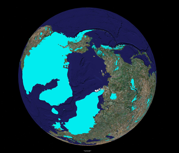
Looks at the northern ice caps today - they too are lop-sided
The answer is how and where glaciers form. Firstly, higher ground is better (most of Siberia is very flat) and secondly they require snowfall - and even today Siberia is relatively dry (hence all those forest fires); during the ice age it was even drier. Indeed, one of the main reasons the woolly mammoths became extinct was because the steppes turned wet when the ice age finished and moister air started reaching Siberia.
So the glaciers/ice caps formed where there were mountains and heavy precipitation (N America, Greenland and Scandinavia) and not where it was flat, low-lying ground with little precipitation.
a reply to: bloodymarvelous
Nice thread!
I think there are 3 main factors that would have determined the location of these glaciers:
1) Wind / air current patterns
2) The water content in the air
3) The air temperature
The likely reason the glaciers are offset is because the snow would dump out in the colder areas for sure, but there would also need to be enough water vapor in the air to form snow. That is probably why the northeastern Eurasian area is not glaciated (less water vapor in the air at that location, due to water being precipitated out already somewhere else in Eurasia, before the air could reach that area).
The western part of North America likely got the benefit of lots of water-rich air from the Pacific Ocean, and the north eastern part of North America, and northern Europe slightly less but for the same reason from air traversing over the Atlantic.
I think you could argue this pattern of glaciation could be possible without the Earth spinning on a different axis, considering air circulation, temperature, and water vapor content alone.
I believe this is covered in depth in a Graham Hancock book from some time ago - but I cannot remember which one. I think the difference being was
that the earths poles shifted to some degree as like a loose skin of an orange moved around the rest of the fruit for some reason - but I forget what
he thought the cause was.
It was widely dismissed by the scientific community so he must have been totally incorrect. Anyone that disagrees with the scientific community is always wrong and should be shamed if not punished.
It was widely dismissed by the scientific community so he must have been totally incorrect. Anyone that disagrees with the scientific community is always wrong and should be shamed if not punished.
edit on 25-1-2019 by Fools because: ...
You can’t really have anything centered on the pole because the earth is spinning and this causes the Coriolis effect. Any precipitation slides
off of the pole.
The bottom picture is rotated like 90 degrees to the left. If they were lined up they'd look very similar no?
The North pole is water. Glaciers start on land usually at high elevation. The snow fall has to exceed melting over thousands of years to get a
glacier started. At a certain point the underlying snow is compressed into ice and begins to flow down the landscape. As the underlying snow is
compressed into ice all the air is squeezed out. An intermediate state of this snow is called firn. Since the North Pole is at sea level, any snow
will melt into the water and not cumulate. When glaciers do advance to the sea, the normal behavior is for icebergs to calve off the glacier into the
water.
Glaciers can cover water, such as the Puget Sound region in Washington State. During the last glaciation Puget Sound was completely covered by an ice sheet over a mile thick. The sides were bolstered by the Olympic Mountains on the west side and the Cascade Mountains on the east side and extended as far south as Olympia. The retreating glacier is what carved out Puget Sound. The Arctic Ocean, in contrast, is an open expanse of water.
Glaciers can cover water, such as the Puget Sound region in Washington State. During the last glaciation Puget Sound was completely covered by an ice sheet over a mile thick. The sides were bolstered by the Olympic Mountains on the west side and the Cascade Mountains on the east side and extended as far south as Olympia. The retreating glacier is what carved out Puget Sound. The Arctic Ocean, in contrast, is an open expanse of water.
a reply to: bloodymarvelous
It always surprises me when people don't understand a simple little concept like things change, you dig deep enough anywhere on the surface of this planet, your bound to find evidence of that. That at one time it was all so much different.
So the poles shifting is still a myth? Oh boy will that be an awesome surprise to people in the future. But dont worry carbon tax will fix that. Not sure what it will fix, it could just be that you all would die poor and indentured when this spinning rock really gets going, but I am sure somebody will use all that $ from the carbon tax to build themselves a spiffy little bunker. Who knows it may even be in pyramid shape.
But hey there is still hope. The earth could be flat after all.
originally posted by: AndyMayhew
Looks at the northern ice caps today - they too are lop-sided
The answer is how and where glaciers form. Firstly, higher ground is better (most of Siberia is very flat) and secondly they require snowfall - and even today Siberia is relatively dry (hence all those forest fires); during the ice age it was even drier. Indeed, one of the main reasons the woolly mammoths became extinct was because the steppes turned wet when the ice age finished and moister air started reaching Siberia.
So the glaciers/ice caps formed where there were mountains and heavy precipitation (N America, Greenland and Scandinavia) and not where it was flat, low-lying ground with little precipitation.
Looking around for maps of the modern Arctic glacier, it looks like you are probably on to something with that.
boingboing.net...
The part of the glacier nearest Northeast Eurasia is melting out first.
I guess it makes sense the precipitation needed to get a glacier started is going to come from water vapor. And water vapor has to come from somewhere warmer, not somewhere colder. Northeastern Eurasia is pretty far from any warmer waters.
The other side of that, despite the maps of ice age glaciers not showing it, there probably was an arctic glacier out in the sea also. There is just no way to confirm it, so they leave it out of the map.
If you look at the modern Arctic glacier in the 1800's, you can see that the sea ice reaches almost all the way to Northeast Eurasia.
blogs.discovermagazine.com...
If the world climate were much colder, then I think it would probably get all the way to land.
edit on 30-1-2019 by bloodymarvelous because: grammar: said "maps" twice in once sentence.
I think your map is wrong. Indiana had glacial ice all the way down to the knobs next to Louisville, KY. The ice went nearly all the way to the
Cincinnati, Ohio area too. The Ice went far enough out into/over the Atlantic ocean that the Indians or caveman people went from France to Virginia.
They found the five pointed Clovis arrow heads in both places. At that time the ocean was miles out into the Atlantic away from Charleston, SC. The
areas with villages and pyramids were uncovered in the Gulf of Mexico and Caribbean areas. The Azores islands would have been bigger with those
pyramids uncovered from water. All the coast lines would be vastly different with less water in the oceans.
a reply to: bloodymarvelous
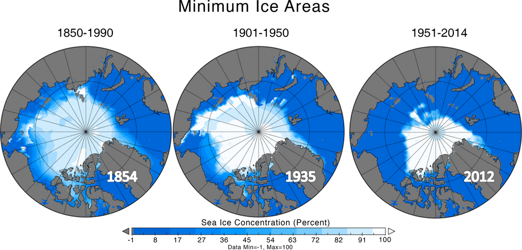
I think maaaybe just maybe you got your definitions mixed up abit.
The things melting in your animated maps are the polar cap.
Glacial meltings not so much.
Glacials too are melting at alarming rates ofcourse but
your map shows the melting of the polar cap.
Glacialias form over land as far as Ive understood it.
This is interesting stuff guys!
Thanks.
You're right that I don't really know what word goes with what. Leave it up to me and we would just call all the glaciers, ice caps, and ice
sheet "big blocks of ice".
I'm just wondering if the ice covering the Arctic ocean would make it all the way to land, and then grow onto North Eastern Eurasia. .... but I guess it wouldn't matter, because there still isn't enough rainfall there for it to grow further once it got there. The rain clouds just have too far to go after they form in the warmer pacific or Atlantic.
I'm just wondering if the ice covering the Arctic ocean would make it all the way to land, and then grow onto North Eastern Eurasia. .... but I guess it wouldn't matter, because there still isn't enough rainfall there for it to grow further once it got there. The rain clouds just have too far to go after they form in the warmer pacific or Atlantic.
edit on 1-2-2019 by bloodymarvelous because:
shorten.
edit on 1-2-2019 by bloodymarvelous because: grammar
a reply to: bloodymarvelous
Hey no prob man iam no expert either
I do like to ponder these things myself aswell..
I think mainly because I live up here and also i find these things are extremely interesting,
allthough i dont understand alot of it.
The 'experts' says both hemispheres was mostly covered with ice at one point. several times.
I guess given enough time glaciers could maybe form on land and grow out over a ice-covered ocean and somehow meet another glacier doing the same thing but going the other way(?) someone more qualified please correct me
But who knows, maybe if that crustal displacement thing happens the artic will be the new equator and this will be someone elses problem.
Thanks!
:-)
new topics
-
James O’Keefe: I have evidence that exposes the CIA, and it’s on camera.
Whistle Blowers and Leaked Documents: 39 minutes ago -
Australian PM says the quiet part out loud - "free speech is a threat to democratic dicourse"...?!
New World Order: 1 hours ago -
Ireland VS Globalists
Social Issues and Civil Unrest: 1 hours ago -
Biden "Happy To Debate Trump"
Mainstream News: 2 hours ago -
RAAF airbase in Roswell, New Mexico is on fire
Aliens and UFOs: 2 hours ago -
What is the white pill?
Philosophy and Metaphysics: 4 hours ago -
Mike Pinder The Moody Blues R.I.P.
Music: 4 hours ago -
Putin, Russia and the Great Architects of the Universe
ATS Skunk Works: 7 hours ago
top topics
-
A Warning to America: 25 Ways the US is Being Destroyed
New World Order: 12 hours ago, 20 flags -
Mike Pinder The Moody Blues R.I.P.
Music: 4 hours ago, 7 flags -
What is the white pill?
Philosophy and Metaphysics: 4 hours ago, 5 flags -
Biden "Happy To Debate Trump"
Mainstream News: 2 hours ago, 5 flags -
Australian PM says the quiet part out loud - "free speech is a threat to democratic dicourse"...?!
New World Order: 1 hours ago, 5 flags -
RAAF airbase in Roswell, New Mexico is on fire
Aliens and UFOs: 2 hours ago, 4 flags -
Putin, Russia and the Great Architects of the Universe
ATS Skunk Works: 7 hours ago, 3 flags -
Ireland VS Globalists
Social Issues and Civil Unrest: 1 hours ago, 2 flags -
James O’Keefe: I have evidence that exposes the CIA, and it’s on camera.
Whistle Blowers and Leaked Documents: 39 minutes ago, 2 flags
active topics
-
James O’Keefe: I have evidence that exposes the CIA, and it’s on camera.
Whistle Blowers and Leaked Documents • 7 • : pianopraze -
Krystalnacht on today's most elite Universities?
Social Issues and Civil Unrest • 8 • : FlyersFan -
Gaza Terrorists Attack US Humanitarian Pier During Construction
Middle East Issues • 87 • : YourFaceAgain -
University of Texas Instantly Shuts Down Anti Israel Protests
Education and Media • 293 • : FlyersFan -
-@TH3WH17ERABB17- -Q- ---TIME TO SHOW THE WORLD--- -Part- --44--
Dissecting Disinformation • 698 • : Thoughtful3 -
Supreme Court Oral Arguments 4.25.2024 - Are PRESIDENTS IMMUNE From Later Being Prosecuted.
Above Politics • 100 • : Vermilion -
Russia Ukraine Update Thread - part 3
World War Three • 5735 • : gortex -
"We're All Hamas" Heard at Columbia University Protests
Social Issues and Civil Unrest • 288 • : FlyersFan -
Biden "Happy To Debate Trump"
Mainstream News • 31 • : theatreboy -
President BIDEN's FBI Raided Donald Trump's Florida Home for OBAMA-NORTH KOREA Documents.
Political Conspiracies • 33 • : theatreboy