It looks like you're using an Ad Blocker.
Please white-list or disable AboveTopSecret.com in your ad-blocking tool.
Thank you.
Some features of ATS will be disabled while you continue to use an ad-blocker.

Mystery Tsunami Hits Iran, Killing 1, And I think They are Lying about the Cause
page: 3share:
a reply to: TrueAmerican
What size of meteorite would you say would be involved then?
The only reason I ask, is because in order to move this much water, it would have had to have been bigger than a car when it hit the ocean, which would make it one of the larger penetrators to have reached the surface of the Earth in some time.
Something the size of a basket ball or a melon would have been too puny to make this much of a wave.
It is also worth pointing out that a .50 cal bullet can be fired with various different charges, different weights depending on the specific round involved, and the weapons system it is being fired from also affects speed. If we were to call it 3,000 feet per second, that would not be a bad average to work from.
Meteorites have even more varied speeds, entering the atmosphere at between 38,000 and 240,000 feet per second, ablation eventually decelerating them down to 9,100 feet per second or so.
a reply to: TrueBrit
Another possibility is that an underwater seamount or volcano erupted, causing the tsunami. The Persian Gulf has an ancient volcanic history. There are all sorts of trapped gases down there.
blogs.platts.com...
Just reading around:
Several years ago a couple of volcanic islands sprang up in the Red Sea, and Saudi Arabia also has a long volcanic history. Southwestern Iran is also full of mud volcanoes, which extend offshore into the Persian Gulf. It is not inconceivable that some new geologic feature has formed on the seabed, and they don't even know about it yet. The area is also a zone of tectonic collision between plates. And that can cause volcanism.
The bottom line is I am not buying the storm explanation. Not even for a minute. That's just too damn much water, moving too damn fast, with multiple incoming wave trains.
Another possibility is that an underwater seamount or volcano erupted, causing the tsunami. The Persian Gulf has an ancient volcanic history. There are all sorts of trapped gases down there.
blogs.platts.com...
Just reading around:
These salt upwellings were due to volcanic activity in the ancient Tethys Sea, which hundreds of millions of years ago covered much of the Arabian Peninsula. The warm, shallow sea, rich in lipid-storing plankton, was fertile ground for the formation of petroleum deposits in the sediments that gradually accumulated under the sea. The process can even today be observed on mud flats flanking the Persian Gulf, where the sediment below surface mats of cyanobacteria (previously known as blue-green algae) is stained black by contemporary oil desposits.
The salt domes provide the cap-rock needed to trap migrating oil in underlying sandy or chalky sediments, but how did they form? Jean-Paul Berger, a Dubai-based geologist, explains that the weight of accumulating sediment that originally formed above more ancient layers of gypsum and other salty minerals, combined with upwards surges of molten magma from below the earth’s crust, subjected the subterranean salts to increasing temperatures and pressures until they melted.The molten salts forced channels through overlying sediment until they reached the surface and spread out to form domes.
The periodic magma surge also sometimes broke through to the surface as active volcanoes, explaining the occurrence on certain islands such as Dalma of massive natural rubble piles consisting of angular gypsum fragments mixed with various heavily crystallized rocks and boulders containing often brightly colored ores of metals such as iron, copper and manganese.
Several years ago a couple of volcanic islands sprang up in the Red Sea, and Saudi Arabia also has a long volcanic history. Southwestern Iran is also full of mud volcanoes, which extend offshore into the Persian Gulf. It is not inconceivable that some new geologic feature has formed on the seabed, and they don't even know about it yet. The area is also a zone of tectonic collision between plates. And that can cause volcanism.
The bottom line is I am not buying the storm explanation. Not even for a minute. That's just too damn much water, moving too damn fast, with multiple incoming wave trains.
originally posted by: TrueAmerican
originally posted by: D8Tee
a reply to: TrueAmerican
North Korea underwater nuke test, only rational explanation.
Ahh, have you looked at a map where NK is in relation to Iran? Not only is that not rational, but it makes no sense. At all.
Yes and no. It is widely believed that NK and Iran have been working on their respective programs hand in hand. However, I have a hard time believing that a test like that would go undetected.
a reply to: Chadwickus
A device suspended in the water at no great depth, with the major force upward to the surface, would spare the mass of water below and cause any force to spread out. It if were an asteroid, we will hear about it from that scientific community in that that is a keen topic today for it. If it were a bomb, everybody will deny it or say nothing.
A device suspended in the water at no great depth, with the major force upward to the surface, would spare the mass of water below and cause any force to spread out. It if were an asteroid, we will hear about it from that scientific community in that that is a keen topic today for it. If it were a bomb, everybody will deny it or say nothing.
edit on 29-3-2017 by Aliensun because: (no reason given)
originally posted by: D8Tee
a reply to: TrueAmerican
North Korea underwater nuke test, only rational explanation.
More like underwater nuke test by India...
India Joins Boycott of Nuclear Weapons Ban Treaty Talks By Big Powers
It could very well be a meteorological tsunami, happens once in a while.
Wiki Meteotsunami
Here is a video showing damage done, if these waves can toss cars around they can sure kill a person, somewhere in South America.
Wiki Meteotsunami
Here is a video showing damage done, if these waves can toss cars around they can sure kill a person, somewhere in South America.
This is what I was thinking.
originally posted by: thedeadtruth
My money would be on an underwater landslide.
There WAS a storm to the west of Dayyer on the 19th. You can see it on the Nullschool Earth web site animations.
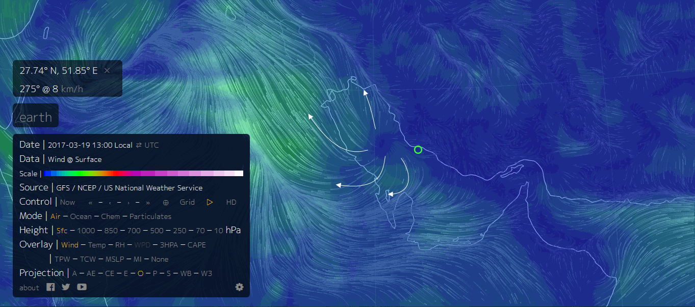
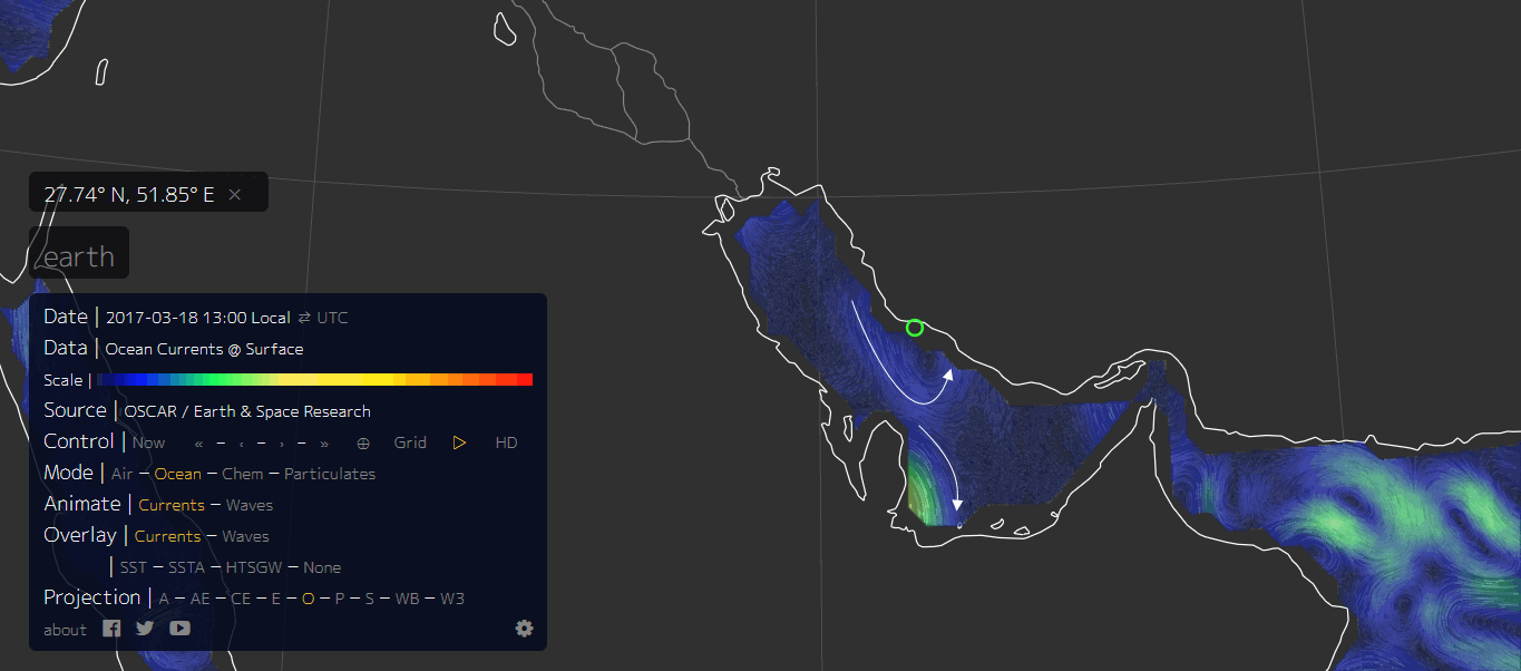
This is as close as I can zoom in, the white arrows show the direction of the overlays, wind, currents, waves. The green circle is the location of Dayyer. The relevant overlay type is highlighted by the orange text.
rightclickviewimages to see full size
Firstly the Wind. The eye of the Storm is pretty obvious, to the west of Dayyer (the green circle)
Then Currents.
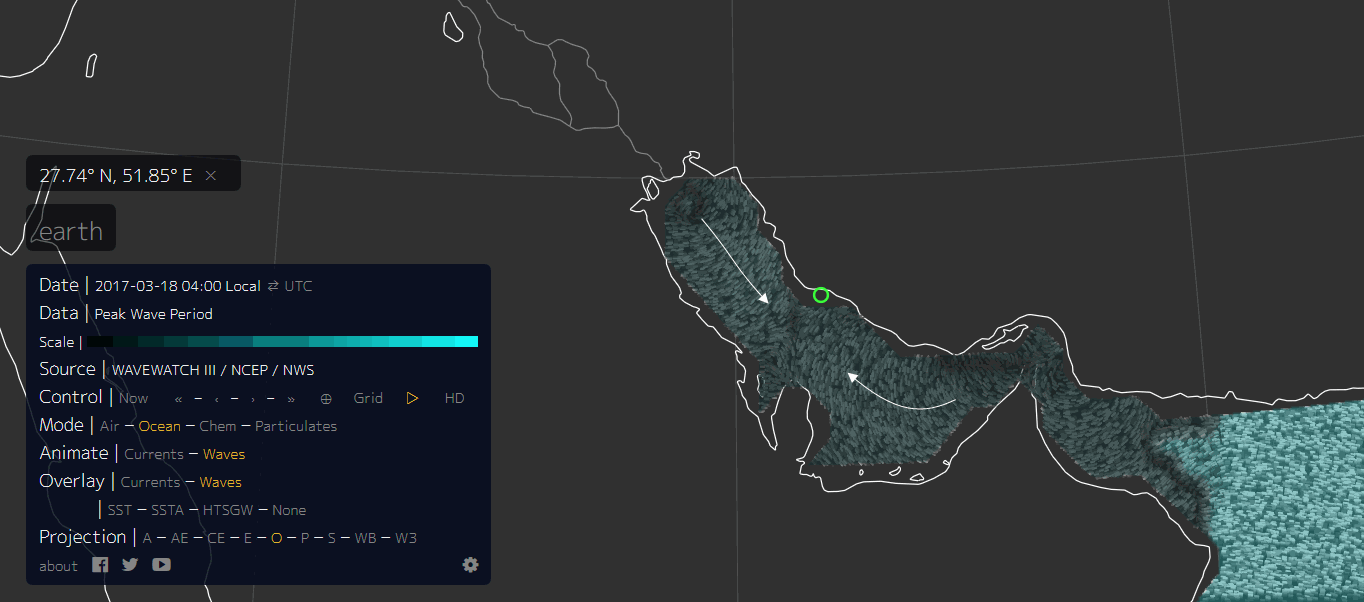
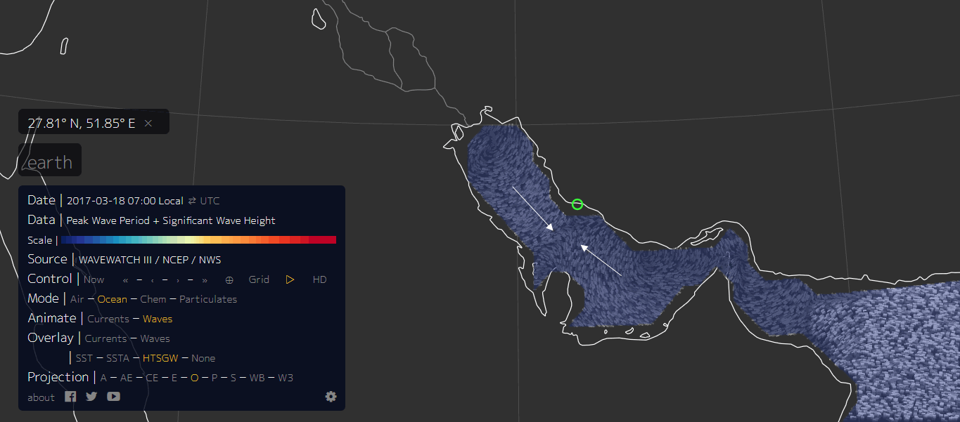
Then Waves (18th March 2017 for comparison). Note the waves are coming from both directions towards a point offshore of Dayyer
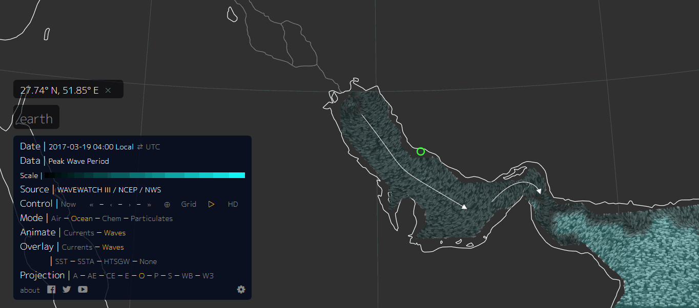
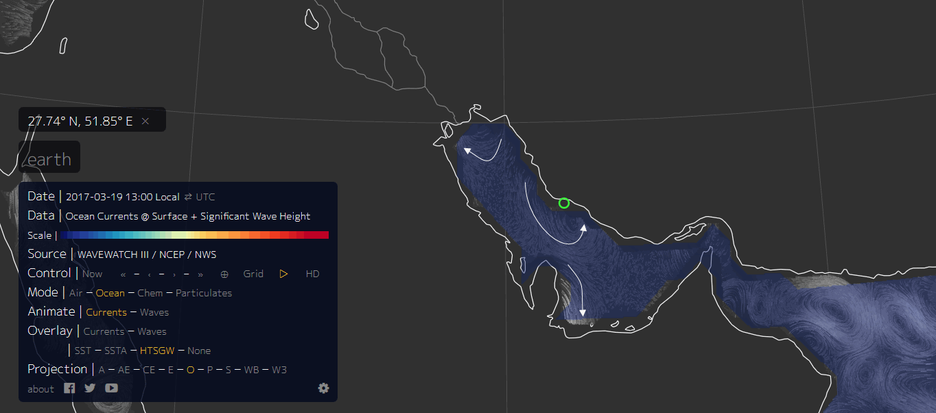
Waves 19th March. By now the waves are just in one direction. This date/time stamp may be after the event had happened. The date stamp you will note is "local" time. The MSM never bother to indicate if the times are UTC or local, there is a 13 hour time difference!!!. Idiots. This is important, as you will see by the last 2 map images.
Peak Wave Period-Significant Wave Height.(18th March 07:00 local, !7th March 18:00)UTC
Again the waves are coming from both directions towards a point offshore of Dayyer
Peak Wave Period-Significant Wave Height. (19th March 13:00 local) We have waves swirling past Dayyer in towards the coast to the east.
One thing to remember is the Mirror story is quite sparce on actual facts, like the exact time, and the exact location. In middle eastern countries the name of a place can often relate to anywhere within 50km, was it Dayyer itself? or some seaside resort 50km east down the coast?
Its more obvious when animated, have a look yourself.
Hopefully the link will open on the date and area I was looking at. If not click on the word Earth to open the menu then follow your nose using the arrows to alter the dates and the words to bring up the overlays.
nu llschoolEarth
So it is quite likely it was a Storm.
Another clue is the 2nd video.
If it is in real time and hasn't been edited time wise, the 2nd wave came in pretty soon after the first one, similar to what you see at the beach on a normal day, sets of seven etc (Surfers would know what I mean) whereas Tsunamis seem to have quite a long period between surges, like 5-10 minutes or longer.
This is as close as I can zoom in, the white arrows show the direction of the overlays, wind, currents, waves. The green circle is the location of Dayyer. The relevant overlay type is highlighted by the orange text.
rightclickviewimages to see full size
Firstly the Wind. The eye of the Storm is pretty obvious, to the west of Dayyer (the green circle)
Then Currents.
Then Waves (18th March 2017 for comparison). Note the waves are coming from both directions towards a point offshore of Dayyer
Waves 19th March. By now the waves are just in one direction. This date/time stamp may be after the event had happened. The date stamp you will note is "local" time. The MSM never bother to indicate if the times are UTC or local, there is a 13 hour time difference!!!. Idiots. This is important, as you will see by the last 2 map images.
Peak Wave Period-Significant Wave Height.(18th March 07:00 local, !7th March 18:00)UTC
Again the waves are coming from both directions towards a point offshore of Dayyer
Peak Wave Period-Significant Wave Height. (19th March 13:00 local) We have waves swirling past Dayyer in towards the coast to the east.
One thing to remember is the Mirror story is quite sparce on actual facts, like the exact time, and the exact location. In middle eastern countries the name of a place can often relate to anywhere within 50km, was it Dayyer itself? or some seaside resort 50km east down the coast?
Its more obvious when animated, have a look yourself.
Hopefully the link will open on the date and area I was looking at. If not click on the word Earth to open the menu then follow your nose using the arrows to alter the dates and the words to bring up the overlays.
nu llschoolEarth
So it is quite likely it was a Storm.
Another clue is the 2nd video.
If it is in real time and hasn't been edited time wise, the 2nd wave came in pretty soon after the first one, similar to what you see at the beach on a normal day, sets of seven etc (Surfers would know what I mean) whereas Tsunamis seem to have quite a long period between surges, like 5-10 minutes or longer.
edit on 03000000878717 by muzzy because: got the images in the wrong order, fixed now
a reply to: hiddenNZ
Yeah I read that NIWA report also, new evidence from coastal inspections. Of course nobody seen it as it happened just after midnight. I can't remember Goose Bay or whether there are anyone living right on the shoreline, guess not otherwise we would have heard the story before now.
i.stuff.co.nz...
Yeah I read that NIWA report also, new evidence from coastal inspections. Of course nobody seen it as it happened just after midnight. I can't remember Goose Bay or whether there are anyone living right on the shoreline, guess not otherwise we would have heard the story before now.
i.stuff.co.nz...
a reply to: muzzy
With that breakdown, I believe supports the theory of rogue wave then. From my post on page 2:
With that breakdown, I believe supports the theory of rogue wave then. From my post on page 2:
rogue waves are not necessarily the biggest waves found on the water; they are, rather, unusually large waves for a given sea state. Rogue waves seem not to have a single distinct cause, but occur where physical factors such as high winds and strong currents cause waves to merge to create a single exceptionally large wave.[2]
a reply to: worldstarcountry
Yeah I would agree.
If the maps are correct they show between 04:00 and 18:00 on the 18th March local time the waves were coming from both directions towards a point offshore of Dayyer, so once they hit each other it is possible they combined and turned inland and hit Dayyer as per the videos as one big wave.
a reply to: TrueAmerican
Not storm surge. You'd need a hurricane of some sort to displace that much water. That would be obvious.
Tsunami possibly.
There is the Makran Subduction Zone off the coasts of both Iran and Pakistan.
Maybe a shelf collapsed and caused the tsunami. I don't see any earthquake activity in the area on that day. However there were some small earthquakes on the 18th around Iran and Pakistan.
Who knows.
a reply to: TrueAmerican
Japan just put a spy satellite that suppose to watch NK....any chance something more sinister with this satellite could be linked?
Any chance Iran detonated a nuke at the right depth as to not show seismic readings.
Radiation detection should be a good indicator. Iran would know this all going in so maybe a new way to test and hide the test?
Also it is cloudy amateur observers would have a harder time detecting anything maybe on top of it all.
originally posted by: Chadwickus
a reply to: D8Tee
Or, wacky idea, it is what they said it is..
A Seiche..
SEICHE
Never heard of suchvacthing before myself...so learning something new
i learned something new. thank you
originally posted by: Vasa Croe
Just wondering, but where are you getting this "1,000 miles" from? I can't find that anywhere in the sourced article.
There is a commenter at the bottom that talks about freak winds being the cause, but no 1000 mile reference anywhere.
someone that uses Spaceweather. com watch, info for video reported that for some reason, but they were incredulous too. This is a report from France 24, it says it was a storm surge after a sudden ocean temperature rise according to Iranian officials. So it was a storm.
edit on 29-3-2017 by smurfy because: Text.
a reply to: randomthoughts12
lots available in regards to footage of underwter nuclear tests. These do not fit the bill, and would have been noticed by many scientists and gov's around the world.
lots available in regards to footage of underwter nuclear tests. These do not fit the bill, and would have been noticed by many scientists and gov's around the world.
a reply to: dragonridr
This story reminds me a lot of something that happened in Florida back in 1992.
www.science-frontiers.com...
This story reminds me a lot of something that happened in Florida back in 1992.
www.science-frontiers.com...
new topics
-
BIDEN Admin Begins Planning For January 2025 Transition to a New President - Today is 4.26.2024.
2024 Elections: 29 minutes ago -
Big Storms
Fragile Earth: 1 hours ago -
Where should Trump hold his next rally
2024 Elections: 4 hours ago -
Shocking Number of Voters are Open to Committing Election Fraud
US Political Madness: 5 hours ago -
Gov Kristi Noem Shot and Killed "Less Than Worthless Dog" and a 'Smelly Goat
2024 Elections: 6 hours ago -
Falkville Robot-Man
Aliens and UFOs: 6 hours ago -
James O’Keefe: I have evidence that exposes the CIA, and it’s on camera.
Whistle Blowers and Leaked Documents: 7 hours ago -
Australian PM says the quiet part out loud - "free speech is a threat to democratic dicourse"...?!
New World Order: 7 hours ago -
Ireland VS Globalists
Social Issues and Civil Unrest: 8 hours ago -
Biden "Happy To Debate Trump"
2024 Elections: 8 hours ago
top topics
-
James O’Keefe: I have evidence that exposes the CIA, and it’s on camera.
Whistle Blowers and Leaked Documents: 7 hours ago, 13 flags -
Blast from the past: ATS Review Podcast, 2006: With All Three Amigos
Member PODcasts: 11 hours ago, 13 flags -
Australian PM says the quiet part out loud - "free speech is a threat to democratic dicourse"...?!
New World Order: 7 hours ago, 12 flags -
Biden "Happy To Debate Trump"
2024 Elections: 8 hours ago, 12 flags -
Mike Pinder The Moody Blues R.I.P.
Music: 11 hours ago, 8 flags -
What is the white pill?
Philosophy and Metaphysics: 10 hours ago, 6 flags -
Shocking Number of Voters are Open to Committing Election Fraud
US Political Madness: 5 hours ago, 6 flags -
RAAF airbase in Roswell, New Mexico is on fire
Aliens and UFOs: 9 hours ago, 5 flags -
Ireland VS Globalists
Social Issues and Civil Unrest: 8 hours ago, 5 flags -
Where should Trump hold his next rally
2024 Elections: 4 hours ago, 4 flags
active topics
-
BIDEN Admin Begins Planning For January 2025 Transition to a New President - Today is 4.26.2024.
2024 Elections • 3 • : xuenchen -
James O’Keefe: I have evidence that exposes the CIA, and it’s on camera.
Whistle Blowers and Leaked Documents • 9 • : Unseendimension -
Krystalnacht on today's most elite Universities?
Social Issues and Civil Unrest • 13 • : TheSingleBillie -
University of Texas Instantly Shuts Down Anti Israel Protests
Education and Media • 313 • : cherokeetroy -
Las Vegas UFO Spotting Teen Traumatized by Demon Creature in Backyard
Aliens and UFOs • 18 • : TheMisguidedAngel -
Falkville Robot-Man
Aliens and UFOs • 8 • : Coelacanth55 -
"We're All Hamas" Heard at Columbia University Protests
Social Issues and Civil Unrest • 295 • : marg6043 -
Gaza Terrorists Attack US Humanitarian Pier During Construction
Middle East Issues • 90 • : Zanti Misfit -
Gov Kristi Noem Shot and Killed "Less Than Worthless Dog" and a 'Smelly Goat
2024 Elections • 39 • : Zanti Misfit -
So this is what Hamas considers 'freedom fighting' ...
War On Terrorism • 268 • : TheWoker