It looks like you're using an Ad Blocker.
Please white-list or disable AboveTopSecret.com in your ad-blocking tool.
Thank you.
Some features of ATS will be disabled while you continue to use an ad-blocker.

8.0 Earthquake Just hit Papua New Guinea Area
page: 130
share:
I think it is less than that, but that's what USGS and PTWC are claiming initially.
earthquake.usgs.gov...
EMSC 7.5
www.emsc-csem.org...
Apparently no tsunami warning as of yet:
www.tsunami.gov...
EMSC already lowered to 7.4
earthquake.usgs.gov...
EMSC 7.5
www.emsc-csem.org...
Apparently no tsunami warning as of yet:
www.tsunami.gov...
edit on Sat Dec 17th 2016 by TrueAmerican because: (no reason given)
EMSC already lowered to 7.4
edit on Sat Dec 17th 2016 by TrueAmerican because: (no reason given)
edit on Sat Dec 17th 2016 by
TrueAmerican because: (no reason given)
edit on Sat Dec 17th 2016 by TrueAmerican because: (no reason given)
edit on
Sat Dec 17th 2016 by TrueAmerican because: (no reason given)
That's quite large, surprising there's no tsunami warning as yet.
Looks like usgs just down graded to a 7.9
Looks like usgs just down graded to a 7.9
edit on 17-12-2016 by twohawks because: (no reason given)
a reply to: twohawks
Hmm, now EMSC has raised it to 8.1
These magnitudes often fluctuate wildly for these big quakes as more data come in and they see propagation.
And immediately now they are back to 8.0
www.emsc-csem.org...
USGS now down to 7.9
Judging from the size of the S-waves worldwide, as well as the raw data from PMG and HNR stations, I estimated initially 7.2 to 7.4
Hmm, now EMSC has raised it to 8.1
These magnitudes often fluctuate wildly for these big quakes as more data come in and they see propagation.
And immediately now they are back to 8.0
www.emsc-csem.org...
edit on Sat Dec 17th 2016 by TrueAmerican because: (no reason given)
USGS now down to 7.9
edit on Sat Dec 17th 2016 by TrueAmerican because: (no reason given)
Judging from the size of the S-waves worldwide, as well as the raw data from PMG and HNR stations, I estimated initially 7.2 to 7.4
edit on Sat
Dec 17th 2016 by TrueAmerican because: (no reason given)
edit on Sat Dec 17th 2016 by TrueAmerican because: (no reason given)
Serious prayers to all who may have been affected by this one.
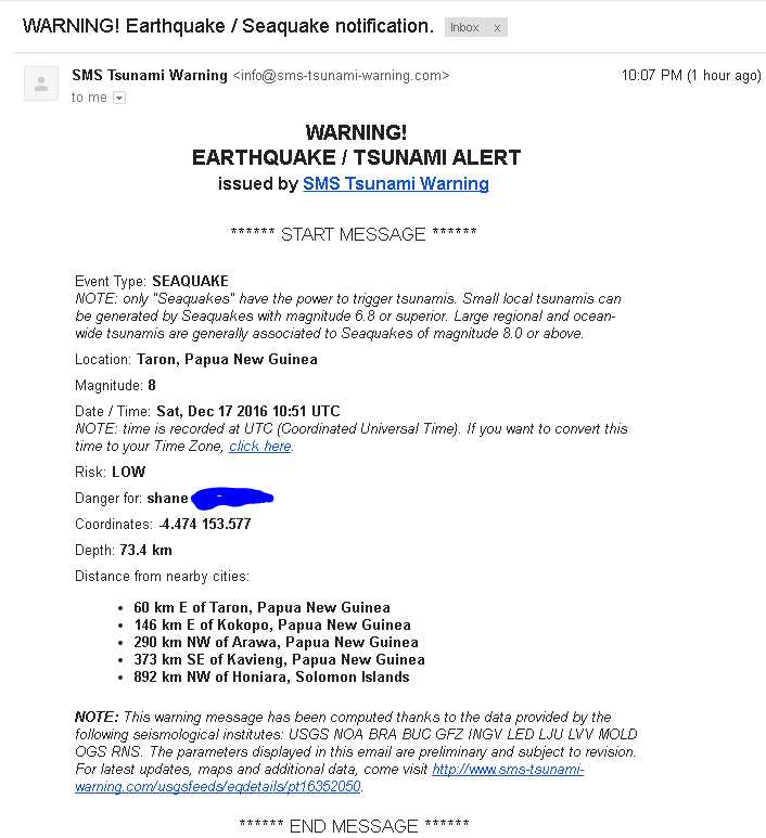
Actually, a local tsunami warning is in effect for this quake:
With the depth of the quake at around 100 km, tsunamis are not usually present.
TSUNAMI WAVES REACHING 1 TO 3 METERS ABOVE THE TIDE LEVEL ARE
POSSIBLE ALONG SOME COASTS OF
PAPUA NEW GUINEA.
* TSUNAMI WAVES ARE FORECAST TO BE LESS THAN 0.3 METERS ABOVE
THE TIDE LEVEL FOR ALL OTHER AREAS.
* ACTUAL AMPLITUDES AT THE COAST MAY VARY FROM FORECAST
AMPLITUDES DUE TO UNCERTAINTIES IN THE FORECAST AND LOCAL
FEATURES. IN PARTICULAR MAXIMUM TSUNAMI AMPLITUDES ON ATOLLS
AND AT LOCATIONS WITH FRINGING OR BARRIER REEFS WILL LIKELY
BE MUCH SMALLER THAN THE FORECAST INDICATES.
* FOR OTHER AREAS COVERED BY THIS PRODUCT A FORECAST HAS NOT
YET BEEN COMPUTED. THE FORECAST WILL BE EXPANDED IF
NECESSARY IN SUBSEQUENT PRODUCTS.
With the depth of the quake at around 100 km, tsunamis are not usually present.
edit on Sat Dec 17th 2016 by TrueAmerican because: (no reason
given)
a reply to: TrueAmerican
hi True American...U r correct.....a warning was issued...
hi True American...U r correct.....a warning was issued...
edit on 17/12/2016 by shaneR because: (no reason given)
edit on 17/12/2016 by shaneR because: add pic
a reply to: TrueAmerican
This map from your USGS link brings the quake into focus.
Interactive map
Since you are really into monitoring earthquake activity, do you know of a good link which will show the P waves from this quake? I'm fascinated by them.
Suspicious0bservers (Ben Davidson) had an alert out 14 hours ago:
Tweet
What happens with me is, seemingly out of the blue, a thought will flash through my mind telling me there will be a large quake somewhere very soon, as it did last night. It happened while I noticed how quiet the solar data was as I felt a pregnant lull. It's a wonder these thoughts make it into my consciousness because my mind is always so busy.
a reply to: TrueAmerican
gday again....one of the first tsunamis i ever remember happened in this vicinity.....
see.... www.abc.net.au...
and also True American and others who like a bit of technical info.... might be interested in this site,,,
nctr.pmel.noaa.gov...
eg...
and heres a page for all us doomporn addicts....
www.drgeorgepc.com...
enjoy....and stay safe out there....
gday again....one of the first tsunamis i ever remember happened in this vicinity.....
July 17, 1998: Papua New Guinea - Following two quakes each measuring 7.0, a tsunami ravaged 30 kilometres
of northern coastline, sweeping away seven villages with a loss of more than 2,000 lives, according to official
statistics. Local sources put the death toll at between 6,000 and 8,000.
see.... www.abc.net.au...
and also True American and others who like a bit of technical info.... might be interested in this site,,,
nctr.pmel.noaa.gov...
eg...
The Aitape 1998 tsunami: Reconstructing the event from interviews and field mapping.
H.L. Davies1, J.M. Davies1, R.C.B.Perembo1 and W.Y. Lus1. 1
University of Papua New Guinea
Abstract
On the evening of 17 July 1998, on the Aitape coast of Papua New Guinea,a strongly felt earthquake was followed some 10-25 minutes later by a destructive tsunami. The tsunami comprised three waves, each estimated to be about 4 m high. The second of the three waves rose to a height of 10-15 m above sea level after it had crossed the shoreline and caused most damage.
Maximum wave heights and greatest damage were recorded along a 14-km sector of coast centered on Sissano Lagoon. In this sector the wave fronts moved from east to west along the coast; all structures were destroyed,
and 20-40 percent of the population was killed. Partial destruction extended 23 km to the southeast and 8 km
to the northwest, and effects of the tsunami were felt as far as 250 km to the west-northwest, beyond the
international border (Joku, this volume).
More than 1600 people are known to have died, with some estimates as high as 2200; 1000 were seriously injured,
and 10,000 survivors were displaced. Information presented in this paper was gathered in the course of a public
awareness campaign in 1998-2002, from interviews with eye-witnesses and from mapping of damage and inundation.
These sources provided new information on the height, shape and timing of the waves; on the possible escape of
petroleum and other gases from beneath the sea floor before and during the tsunami; on unusual sound effects that
preceded the waves, and lighting effects that followed; on possible deep circulation (to 250 m) of sea water in the waves. We also recorded 50-70 cm of subsidence of the coastal sand barrier in the sector of most destruction and noted the resilience and potential protective capacity of certain species of trees.
Eye-witness accounts indicate that the tsunami reached the shore at between 09:00 and 09:08 UT, which is earlier than is permitted by published models of the timing and location of the source of the tsunami.
and heres a page for all us doomporn addicts....
www.drgeorgepc.com...
enjoy....and stay safe out there....
edit on 17/12/2016 by shaneR because: tidy up typos
edit on 17/12/2016 by shaneR because: (no reason given)
The Quake struck in their earthquake warning area... They have been getting better at their forecast of potential EQ IMO
At 1:30 in the video they show the high alert area youtu.be...
At 1:30 in the video they show the high alert area youtu.be...
originally posted by: brokenghost
a reply to: TrueAmerican
It gets worse. 8.0 is only the Beginning.
You do know earthquakes happen every year since the dawn of time right?
What about this one prompted your statement and hopefully it's something more legit then "A YouTube video with ominous music"
new topics
-
President BIDEN's FBI Raided Donald Trump's Florida Home for OBAMA-NORTH KOREA Documents.
Political Conspiracies: 3 hours ago -
Maestro Benedetto
Literature: 5 hours ago -
Is AI Better Than the Hollywood Elite?
Movies: 5 hours ago -
Las Vegas UFO Spotting Teen Traumatized by Demon Creature in Backyard
Aliens and UFOs: 8 hours ago -
2024 Pigeon Forge Rod Run - On the Strip (Video made for you)
Automotive Discussion: 9 hours ago -
Gaza Terrorists Attack US Humanitarian Pier During Construction
Middle East Issues: 10 hours ago -
The functionality of boldening and italics is clunky and no post char limit warning?
ATS Freshman's Forum: 11 hours ago -
Meadows, Giuliani Among 11 Indicted in Arizona in Latest 2020 Election Subversion Case
Mainstream News: 11 hours ago -
Massachusetts Drag Queen Leads Young Kids in Free Palestine Chant
Social Issues and Civil Unrest: 11 hours ago
top topics
-
President BIDEN's FBI Raided Donald Trump's Florida Home for OBAMA-NORTH KOREA Documents.
Political Conspiracies: 3 hours ago, 25 flags -
Krystalnacht on today's most elite Universities?
Social Issues and Civil Unrest: 14 hours ago, 9 flags -
University of Texas Instantly Shuts Down Anti Israel Protests
Education and Media: 17 hours ago, 8 flags -
Weinstein's conviction overturned
Mainstream News: 13 hours ago, 8 flags -
Supreme Court Oral Arguments 4.25.2024 - Are PRESIDENTS IMMUNE From Later Being Prosecuted.
Above Politics: 14 hours ago, 8 flags -
Massachusetts Drag Queen Leads Young Kids in Free Palestine Chant
Social Issues and Civil Unrest: 11 hours ago, 7 flags -
Gaza Terrorists Attack US Humanitarian Pier During Construction
Middle East Issues: 10 hours ago, 7 flags -
Las Vegas UFO Spotting Teen Traumatized by Demon Creature in Backyard
Aliens and UFOs: 8 hours ago, 6 flags -
Meadows, Giuliani Among 11 Indicted in Arizona in Latest 2020 Election Subversion Case
Mainstream News: 11 hours ago, 5 flags -
2024 Pigeon Forge Rod Run - On the Strip (Video made for you)
Automotive Discussion: 9 hours ago, 4 flags
active topics
-
President BIDEN's FBI Raided Donald Trump's Florida Home for OBAMA-NORTH KOREA Documents.
Political Conspiracies • 14 • : WeMustCare -
Hate makes for strange bedfellows
US Political Madness • 47 • : 19Bones79 -
-@TH3WH17ERABB17- -Q- ---TIME TO SHOW THE WORLD--- -Part- --44--
Dissecting Disinformation • 689 • : daskakik -
University of Texas Instantly Shuts Down Anti Israel Protests
Education and Media • 265 • : Astrocometus -
Gaza Terrorists Attack US Humanitarian Pier During Construction
Middle East Issues • 27 • : ToneD -
Reason of the Existence
The Gray Area • 21 • : BingoMcGoof -
Supreme Court Oral Arguments 4.25.2024 - Are PRESIDENTS IMMUNE From Later Being Prosecuted.
Above Politics • 85 • : Sookiechacha -
Chris Christie Wishes Death Upon Trump and Ramaswamy
Politicians & People • 24 • : nugget1 -
New whistleblower Jason Sands speaks on Twitter Spaces last night.
Aliens and UFOs • 63 • : pianopraze -
SETI chief says US has no evidence for alien technology. 'And we never have'
Aliens and UFOs • 74 • : Justoneman
30