It looks like you're using an Ad Blocker.
Please white-list or disable AboveTopSecret.com in your ad-blocking tool.
Thank you.
Some features of ATS will be disabled while you continue to use an ad-blocker.

Mars. Three objects at the same distance from each other. The forgotten smoking gun?
page: 5share:
originally posted by: Wolfenz
So your saying ...... you dont see an Anomaly here ?
what is Circled
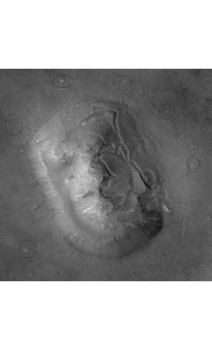
I see them, but are they really anomalies? What's anomalous about them? Their positions?
and what are the ODDs of that ?
To me, odds have nothing to do with a thing being natural or not, as we do not know the processes involved in creating those things and so have no way of calculating any odds about it.
from what i see...
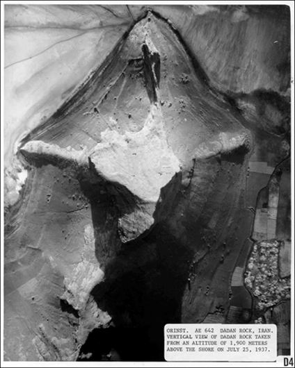
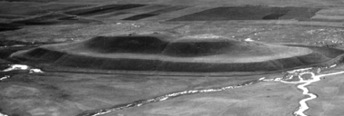
It looks uncanny familiar with this MAN MADE Mound
Named Tepe in Malik Shah Iran
Here on Earth ..
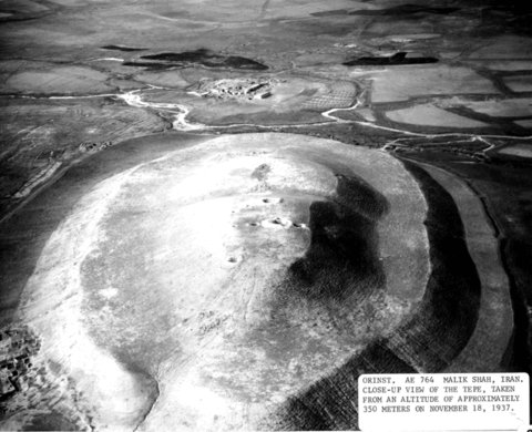
It does, but from what I remember about that Tepe it was only partially man-made, the lower part is natural. Also, even if it was completely man-made, when you look at the area around it you can see that it's the only formation like that in that area, and that it's relatively low.
The "face" on Cydonia is in an area full of formations like that (although with different shapes) that appear to have more or less the same height, so the "face" doesn't look out of place in that area.
originally posted by: randyvs
a reply to: enjoylife
NASA, masters at bolstering public support for their missions.
Doctor some images, leak 'em to the public and then deny everything
they wanted you to see in the first place is even there. Because it isn't.
It's the classic bait and switch that dangles false evidence in regards to
what men want more than anything. Proof of any gods/aliens or just
anything. Lizards, snake, stone, anything that leads men away from
belief in the one true Creator. Surely not all of you are so ignorant
that you can't see this is what NASA is doing?
Why would NASA want to lead people away from the belief in "the one true Creator"?
I don't see the point.
Anyway, believing in a Creator would be belief in Alien life...would it not?
I notice this topic's subject matter also became the topic of SecureTeam10's video upload, yesterday, although not covered and discussed as in-depth
as it is here, on ATS.
Strange.
Strange.
originally posted by: ArMaP
originally posted by: Wolfenz
So your saying ...... you dont see an Anomaly here ?
what is Circled
I see them, but are they really anomalies? What's anomalous about them? Their positions?
and what are the ODDs of that ?
To me, odds have nothing to do with a thing being natural or not, as we do not know the processes involved in creating those things and so have no way of calculating any odds about it.
from what i see...
It looks uncanny familiar with this MAN MADE Mound
Named Tepe in Malik Shah Iran
Here on Earth ..
It does, but from what I remember about that Tepe it was only partially man-made, the lower part is natural. Also, even if it was completely man-made, when you look at the area around it you can see that it's the only formation like that in that area, and that it's relatively low.
The "face" on Cydonia is in an area full of formations like that (although with different shapes) that appear to have more or less the same height, so the "face" doesn't look out of place in that area.
Well I speak of Anomalies because these type Objects something like markers are going around
this Mound ... and its not Really exactly the right Equal Distance, but pretty close , A Possible land slide Perhaps , from a possible destruction of some kind "quake" a rush of water etc..
it shows in legit NASA Photos ..
Natural formation or not ,, and could of been a Natural Mound and carved in at some time ago
the beveled slope around the outside perimeter of the face Mound is like that of the Tepe in Iran ( what it reminds me is a Moat ) and Im Assuming on the Mars Mound aka Face of Mars is partially Buried ... just as over time the landing equipment of Curiosity is now Buried from overtime from exposure
but I see you Agree that its similar :: indeed it does ..
yes Cydonia is Full of Formations, in different shapes and sizes and has a lot of Geometric measurements
as some have claimed ....
click to enlarge
do you know what i have a problem with Also
in that photo above ,,,
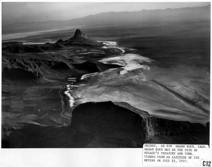
There are TWO ( 2) like 5 sided Pyramid like Structured Mounds
that are close to the same , just distantly Apart .. One Smaller and one Bigger
as they look like this ...
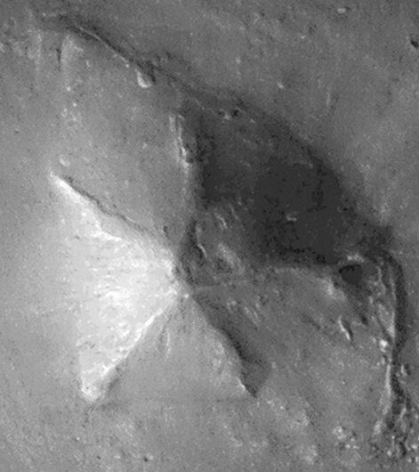
and the 5 sided pyramid mound ( Dadan Rock ) in Iran
which is pretty well worn fro exposure and near a body of water
and its another Partially man made feat ..
was Once considered a Tomb and Treasury
side view as you can see its well worn and concave
The "face" on Cydonia is in an area full of formations like that (although with different shapes) that appear to have more or less the same height, so the "face" doesn't look out of place in that area
Right ... although some would say the Geometry is Amazing for a Natural Formation ...
and lets say it is ! doesn't mean that it could of been Altered Manipulated by some Sentient being ..
right ? from a open mind of Course ..
Remember we cant rule alot out Now ...
originally posted by: Wolfenz
Well I speak of Anomalies because these type Objects something like markers are going around
this Mound ... and its not Really exactly the right Equal Distance, but pretty close , A Possible land slide Perhaps , from a possible destruction of some kind "quake" a rush of water etc..
The fact that they are not evenly spaced and what appears to be the edge of a slightly different ground makes me think that they may really be the result of the erosion of the "face", maybe larger blocks that fell down the slopes.
it shows in legit NASA Photos ..
I know it does, I recognise the photo you posted.
And although we can't really rule out intelligent intervention I don't see any reason to give intelligent intervention a higher probability of being the right answer than to natural geological processes, similar to those we know on the Earth.
Back to the original premise;
Equidistant objects in nature are certainly possible, we see it in the furrows of the sand dunes in valleys as well as the way basalt crystallizes in long parallel structures. The wind across the flat plains also seems to expose some modal frequency in surface dust, so possibly we are looking at a rocky ridge where the wind has sculpted an erosion signature or merely moved dust. It is really hard to tell without some higher resolution imagery or actually visiting a site like that, which to me, is more important.
Would it not be great if in the sunset years of these missions, if the rovers could be tasked with re-tracing their paths and investigating some of the most controversial objects that we have all seen and wondered about. I understand that the missions are tasked with a much more important master plan of exploration, but there are certainly a few objects, and we all know what they are, that really need to be manipulated and detail scanned for answers to exactly what they are, and of course, what they are not.
edit on 8-12-2016 by charlyv because: spelling , where caught
originally posted by: ArMaP
originally posted by: Wolfenz
Well I speak of Anomalies because these type Objects something like markers are going around
this Mound ... and its not Really exactly the right Equal Distance, but pretty close , A Possible land slide Perhaps , from a possible destruction of some kind "quake" a rush of water etc..
The fact that they are not evenly spaced and what appears to be the edge of a slightly different ground makes me think that they may really be the result of the erosion of the "face", maybe larger blocks that fell down the slopes.
it shows in legit NASA Photos ..
I know it does, I recognise the photo you posted.
And although we can't really rule out intelligent intervention I don't see any reason to give intelligent intervention a higher probability of being the right answer than to natural geological processes, similar to those we know on the Earth.
The fact that they are not evenly spaced and what appears to be the edge of a slightly different ground makes me think that they may really be the result of the erosion of the "face", maybe larger blocks that fell down the slopes.
why would if matter if they are evenly spaced ... that the point im making..
and if they were ... what would happen .. ?
The Fact: is they are going around this Mound,
connecting the dots ( markers ) the ones you can see
and I can see it plain as Day... ive been saying this for about a decade now ..
Maybe larger Block falling down the Slope ???
are you kidding me!
Again what are the Ratio ( odds ) of Rocks falling Down the Slope making a Geometric Pattern around the Mound
it shows in legit NASA Photos ..
It would be Nice if they show these markers a litter closer
know it does, I recognise the photo you posted.
Right cant Refute that when NASA JPL etc are Showing them
And although we can't really rule out intelligent intervention I don't see any reason to give intelligent intervention a higher probability of being the right answer than to natural geological processes, similar to those we know on the Earth.
Well Thanks for that ...
Higher Probability ?? nah just it weights in a Balance of a 50/50 to me
Now if those Markers are Not there or NASA Deny's those Markers and refuse explain them ..
nor ,, what they are ...
My Guess is they could be left over results from a Cad Program , Morphing Program , in something like Photoshop ,...
In all Armap They are there in the Legit Photos .. just as there is two exactly like type 5 sided pyramids like Mounds in Cydonia , as N.A.S.A. Sites ..has Shown those too ...
hey im a Skeptic like everyone else ...
Neil Degrass Tyson thinks Differently now in the Cosmos
Mr Tyson No Longer thinks
If We cant Do it ( earth ) Civ type 0 ,
They ( E.T.s ) cant Do it... Ideology.. anymore
Just because its Not Plausible for the People Earth a Civ type zero
to go over to Mars yet .. Doesn't mean a Much Older Sentient Civilization from another World
came Here on this planet or Mars as a Outpost a Civilization Type 2 or 3 ..
in Our Ancient past.. that went through the same steps and cycles as we are taking now..
I wonder , Has Anybody questioned NASA about those Dot "Markers " ?
and we have Real Scientist's seeing Possible artificial structures around a star many Light years away
KIC 8462852
and dont forget the Hologram Simulation Universe either ...
as some Top Scientist says it could be plausible ..
so now in my Open Critical thinking Mind ...
thinks anything could be manifestly possible ... and explainable ..
originally posted by: Ectoplasm8
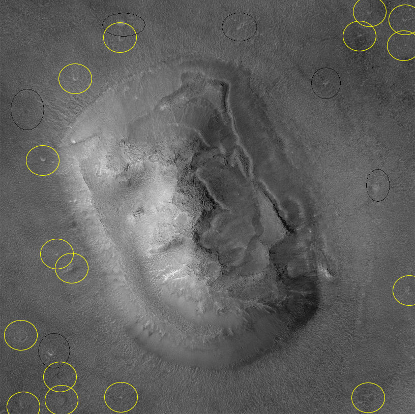
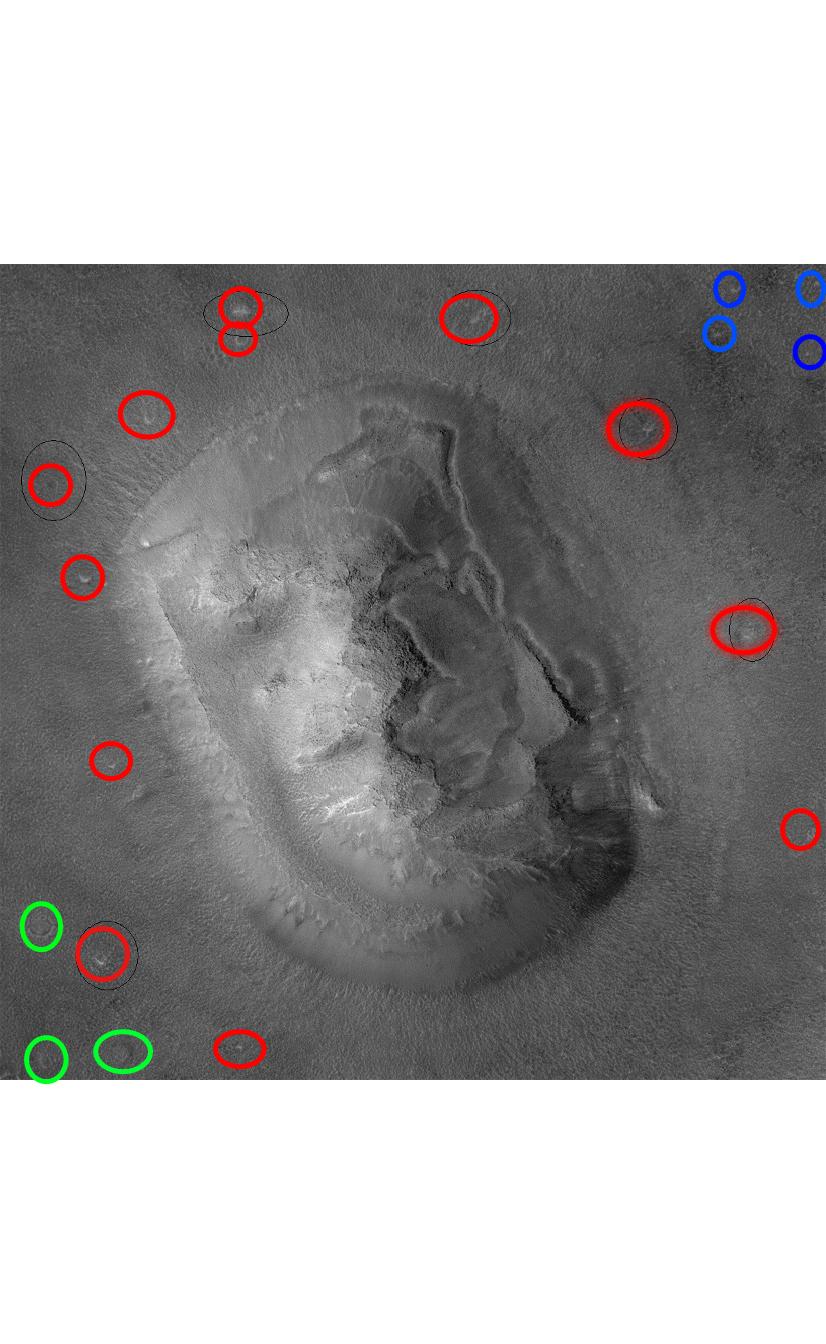
originally posted by: Wolfenz
What about all of the other similar "anomalies" I've circled in yellow? This is just in the tight shot you posted, I'm sure a wider one would show many more.
Obviously these aren't markers, they're just naturally occurring.
why yes i know of them too ..
what you circle goes right around the Mound and there is a 4 cluster close equal distance ..
the bottom cluster corner are some tiny circles a little bigger sizes that you circled yellow ..
I was more focused on a pattern ... around the Mound ...
yeah maybe i should of circle them a different color ...
Now it more looks like a soil Moving Land slide Shift now that moved those markers...
probably is the reason the Mound looks partially buried as the rest of the Area Sediment silt what have you
Red around the face Blue those 4 markers and Green small Round raised mounds
edit on 52016FridayfAmerica/Chicago12343 by Wolfenz because: (no reason given)
These are nothing more than Buttes.
If you go to the original images from the CGX camera these are taken from there are lots more in the same region too - getting 3 in a line is just one of those things that will happen sooner or later but it is a statistical anomaly, nothing more.
Sorry.
If you go to the original images from the CGX camera these are taken from there are lots more in the same region too - getting 3 in a line is just one of those things that will happen sooner or later but it is a statistical anomaly, nothing more.
Sorry.
a reply to: Wolfenz
Remember the Themis infra red image's of the area and how the supposed compression artifact's which seemed to show extensive construction below the present day surface of the site lined up perfectly with these feature's perfectly.
www.abovetopsecret.com...
www.bibliotecapleyades.net...
In defense of the Skeptic's on the Themis image's though while we are learning to used Aeriel imagery including IR image's to pinpoint site's of interest on earth it is highly unlikely that even the best IR sensor could have captured such detail so the IR imaged may be PARTIALLY simply image artifact's but I strongly suspect that this is not entirely the case and there is something there.
The basic premise was that if this is is a city then it was buried in a cataclysmic flood probably caused by the same destructive impact which may have created both the Valles Marineras were Mars seem's to have nearly been split in two and the massive Olympus Monze which may have been the last gasp of the planet's core after it was impacted and disrupted entirely by the force of that impact with left one hemisphere of mars far more devastated than the other hemisphere.
This floor of water or even mud then froze as the atmosphere had been almost entirely blasted away in this scenario which is at odd's with NASA's current slow depletion by solar wind erosion of MARS atmosphere and is more in line with the planet's core having been killed by a massive impact with the subsequent loss of it's magnetosphere as well as the already massive atmospheric depletion caused by this event.
www.csmonitor.com...
enterprisemission.com...
enterprisemission.com...
edit on 9-12-2016 by LABTECH767 because: (no reason given)
originally posted by: charlyv
Would it not be great if in the sunset years of these missions, if the rovers could be tasked with re-tracing their paths and investigating some of the most controversial objects that we have all seen and wondered about. I understand that the missions are tasked with a much more important master plan of exploration, but there are certainly a few objects, and we all know what they are, that really need to be manipulated and detail scanned for answers to exactly what they are, and of course, what they are not.
The closest thing we have now is HiWish, where you can suggest targets for HiRISE photos. Not much, but if they think it's a good target they will take the photos.
a reply to: LABTECH767
I have questioned the same thing ... a major Impact ... Collision ...
The Idea is still in the Air ... and we do have a Asteroid Belt between Mars and Jupiter
Theorized a Destroyed exploded Planet ..that was Named PHAETON or Planet V byJohn Chambers and Jack J. Lissauer NASA Scientists
Fifth planet (hypothetical)Phaeton (hypothetical planet)
en.wikipedia.org...(hypothetical_planet)
Planet V
en.wikipedia.org...
Could of Caused Mars to Ruin..
Valles Marineris: Facts About the Grand Canyon of Mars
www.space.com...
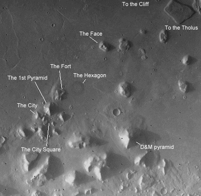
to go deeper one has to know the location of Cydonia
en.wikipedia.org...(region_of_Mars)
Massive Water Flow everywhere
Acidalia Planitia
en.wikipedia.org...
Arabia Terra
en.wikipedia.org...
any how this is interesting
face of mars
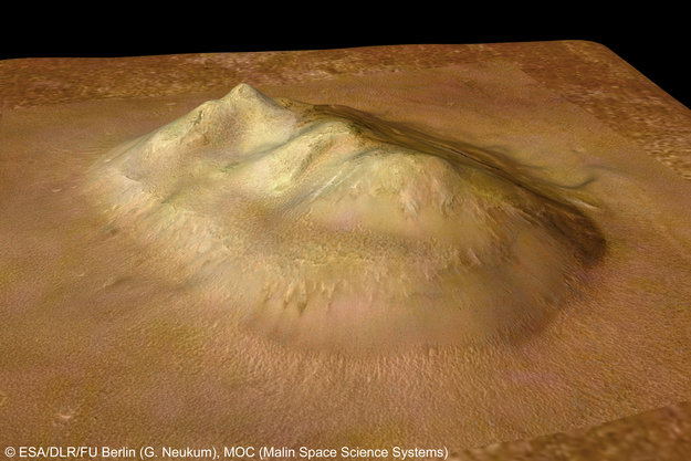
www.esa.int...
Tepe Iran ( earth )
The basic premise was that if this is is a city then it was buried in a cataclysmic flood probably caused by the same destructive impact which may have created both the Valles Marineras were Mars seem's to have nearly been split in two and the massive Olympus Monze which may have been the last gasp of the planet's core after it was impacted and disrupted entirely by the force of that impact with left one hemisphere of mars far more devastated than the other hemisphere.
This floor of water or even mud then froze as the atmosphere had been almost entirely blasted away in this scenario which is at odd's with NASA's current slow depletion by solar wind erosion of MARS atmosphere and is more in line with the planet's core having been killed by a massive impact with the subsequent loss of it's magnetosphere as well as the already massive atmospheric depletion caused by this event.
I have questioned the same thing ... a major Impact ... Collision ...
The Idea is still in the Air ... and we do have a Asteroid Belt between Mars and Jupiter
Theorized a Destroyed exploded Planet ..that was Named PHAETON or Planet V byJohn Chambers and Jack J. Lissauer NASA Scientists
Fifth planet (hypothetical)Phaeton (hypothetical planet)
en.wikipedia.org...(hypothetical_planet)
Planet V
en.wikipedia.org...
Could of Caused Mars to Ruin..
Valles Marineris: Facts About the Grand Canyon of Mars
www.space.com...
Valles Marineris stretches east-west just below the Martian equator. It starts in the west in the Noctis Labyrinthus, a system of maze-like valleys and canyons, and stretches around 20 percent of the planet to the chaotic terrain near the Chryse Planitia basin. The canyon system contains a number of different features that give clues to its formation. Collapse pits created by rushing water eating away at the land, massive floods, and seeping along canyon walls all point to water just at or beneath the surface at some point in the Martian history. Cracks in the crust, cliffs and walls, and landslides also exist along the expanse of Valles Marineris.
to go deeper one has to know the location of Cydonia
Cydonia lies in the planet's northern hemisphere in a transitional zone between the heavily cratered regions to the south and relatively smooth plains to the north. Some planetologists believe that the northern plains may once have been ocean beds[8] and that Cydonia may once have been a coastal zone.[
en.wikipedia.org...(region_of_Mars)
Massive Water Flow everywhere
Acidalia Planitia
en.wikipedia.org...
Arabia Terra
en.wikipedia.org...
any how this is interesting
face of mars
www.esa.int...
Tepe Iran ( earth )
a reply to: Wolfenz
If evidence of an advanced humanoid civilization on Mars could be proved then the link would become far more than suggestive and with a single stroke that old argument against artifact's from a previous super civilization being possible and even to exist on earth would be thrown out of the window also simply because of the distinct similarity between these two artifact's if a link could then be proven this would in turn then throw out a whole raft of idea's and theory's about how old humanity really is as well as were and how it came into being etc.
So there are a lot of very strong vested interest's in simply not letting this potential truth be revealed also of note the Video had a very good argument about how JPL would more or less go out of business if such previous advanced civilization could be proven to have existed regardless of whether it be of human or non human origin.
Some of these people would likely kill to protect there job's and even there professional field's which then would be shown to be based on superstition and I suspect at least some of those people may potentially have done so in the past as well as the rumoured destruction of evidence right here on earth such as the supposedly disproven story's about some leading museum's actually not just losing artifact's indicative of previous civilization's that should not exist but actually destroying them or in one case supposedly sinking them in deep water after shipping them out into the middle of the ocean on an ocean going barge?, these were not technology though just thing's that would or could perhaps have caused a headache for some professional's.
originally posted by: Wolfenz
why would if matter if they are evenly spaced ... that the point im making..
and if they were ... what would happen .. ?
If they were evenly spaced then I would give the artificial possibility more "weight".
No.
Maybe larger Block falling down the Slope ???
are you kidding me!
Again what are the Ratio ( odds ) of Rocks falling Down the Slope making a Geometric Pattern around the Mound
That depends in part of the shape of the mound. A rock rolling down hill would get up to a specific speed, related to the angle of the slope and how high up that sloped the rock started rolling down. If the slope has the same angle all around the mound and there's a layer at a specific altitude from which is more likely that rocks will roll down hill then the odds of all rocks stopping at more or less the same distance from the mound are higher than if the mound had different slope angles in different places.
it shows in legit NASA Photos ..
Why that obsession with it being a legit NASA photo? I don't remember anyone saying it wasn't.
It would be Nice if they show these markers a litter closer
Wish granted.

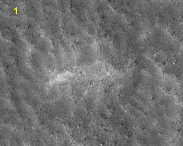
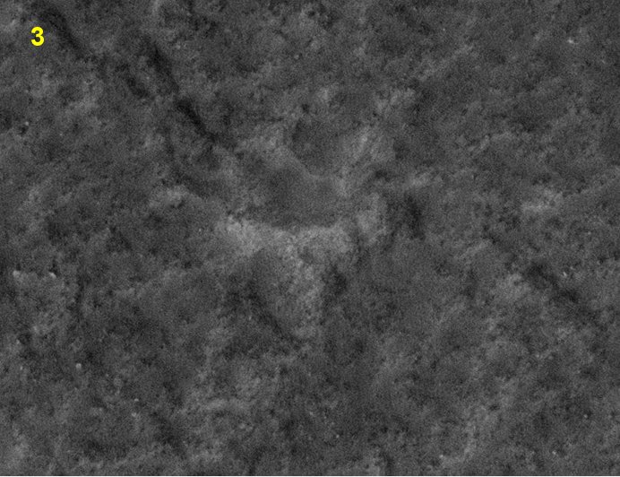
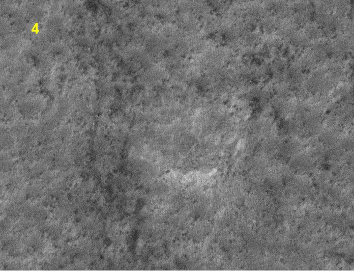
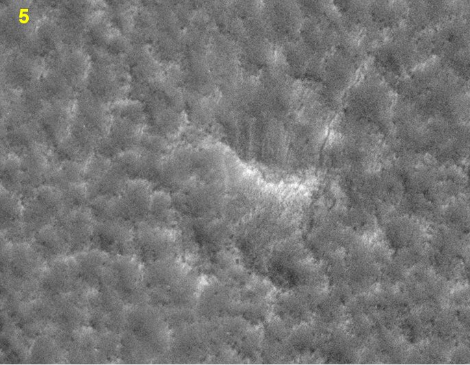
This way we can see that they are not boulders that rolled down hill.
My Guess is they could be left over results from a Cad Program , Morphing Program , in something like Photoshop ,...
Have you done anything like that in one of those programs? I ask because I don't see any need for markers in any of those programs, at least markers that will appear in the final image.
I wonder , Has Anybody questioned NASA about those Dot "Markers " ?
I only know I haven't.
originally posted by: LABTECH767
So there are a lot of very strong vested interest's in simply not letting this potential truth be revealed also of note the Video had a very good argument about how JPL would more or less go out of business if such previous advanced civilization could be proven to have existed regardless of whether it be of human or non human origin.
Why would the JPL "go out of business"?

a reply to: Wolfenz
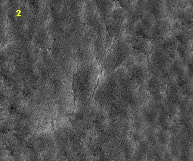
I think you're trying way too hard to convince yourself these are intelligently created. What you have circled matches the surrounding area. If I move the top two "markers" you circled, next to the areas in the upper right corner, they match:

How do you explain if these were created and not naturally occurring, the consistency with the other points in the corner?
It's the same as the topic of this thread with the three "objects." Michael Shermers patternicity comes to mind.
I think you're trying way too hard to convince yourself these are intelligently created. What you have circled matches the surrounding area. If I move the top two "markers" you circled, next to the areas in the upper right corner, they match:
How do you explain if these were created and not naturally occurring, the consistency with the other points in the corner?
It's the same as the topic of this thread with the three "objects." Michael Shermers patternicity comes to mind.
edit on 10-12-2016 by Ectoplasm8 because: (no reason given)
originally posted by: ArMaP
originally posted by: Wolfenz
why would if matter if they are evenly spaced ... that the point im making..
and if they were ... what would happen .. ?
If they were evenly spaced then I would give the artificial possibility more "weight".
No.
Maybe larger Block falling down the Slope ???
are you kidding me!
Again what are the Ratio ( odds ) of Rocks falling Down the Slope making a Geometric Pattern around the Mound
That depends in part of the shape of the mound. A rock rolling down hill would get up to a specific speed, related to the angle of the slope and how high up that sloped the rock started rolling down. If the slope has the same angle all around the mound and there's a layer at a specific altitude from which is more likely that rocks will roll down hill then the odds of all rocks stopping at more or less the same distance from the mound are higher than if the mound had different slope angles in different places.
it shows in legit NASA Photos ..
Why that obsession with it being a legit NASA photo? I don't remember anyone saying it wasn't.
It would be Nice if they show these markers a litter closer
Wish granted.
This way we can see that they are not boulders that rolled down hill.
My Guess is they could be left over results from a Cad Program , Morphing Program , in something like Photoshop ,...
Have you done anything like that in one of those programs? I ask because I don't see any need for markers in any of those programs, at least markers that will appear in the final image.
I wonder , Has Anybody questioned NASA about those Dot "Markers " ?
I only know I haven't.
No.
Maybe larger Block falling down the Slope ???
are you kidding me!
Obviously you Answered your Own Question
from the Blow Ups you had Posted ...
they are not Rocks , or some kind of stone
but they those " Markers "
seem all indented..
or like something was " cemented " then ripped out " removed "
or Dug out ... explosion, Flood, extreme wind ,
Now its even more a Mystery..
were did you find these photos these blow ups ?
it shows in legit NASA Photos ..
Why that obsession with it being a legit NASA photo? I don't remember anyone saying it wasn't.
Fair Enough ... as from those Sites the actual JPG, GIF, PNG, Would may have a copy right within the file
or Link it to the actual site in a Post ..
My Guess is they could be left over results from a Cad Program , Morphing Program , in something like Photoshop ,... ////
Have you done anything like that in one of those programs? I ask because I don't see any need for markers in any of those programs, at least markers that will appear in the final image.
Yes I have, Also used Different Paint & paint edit programs..
its pointless to even suggest a cad program now seeing you just placed blown up photos of the location of those Dots : " markers "
do you have links ? to where those pics come from ?
a reply to: Ectoplasm8
sorry im not following you .. meaning ... ?
are you saying Double Copied prints or something
well thats a Photoshop scheme trick and im not seeing in the NASA Photos
The Markers are all Different indentations around the Face of Marks
as ArMAP has Show in the Blow Ups of those markers
that been recently posted...
It even makes it more of a mystery to me ..
Now Can Man
Go to Mars and Build a Outpost and Live there for a few years ?
and if you Answer yes ...
then Why Not a Sentient High Advanced Being other then Ourselves ..
and say thousands of years Ahead of us in Technology...
Place a Outpost or Habitat etc.. on Mars ..
when Early MAN were in caves and in animal skins ..
There is another larger feature on Mars comprised of three almost-equidistant objects in an almost-straight line. That would be the three volcanoes
that are collectively known as "Tharsis Montes"
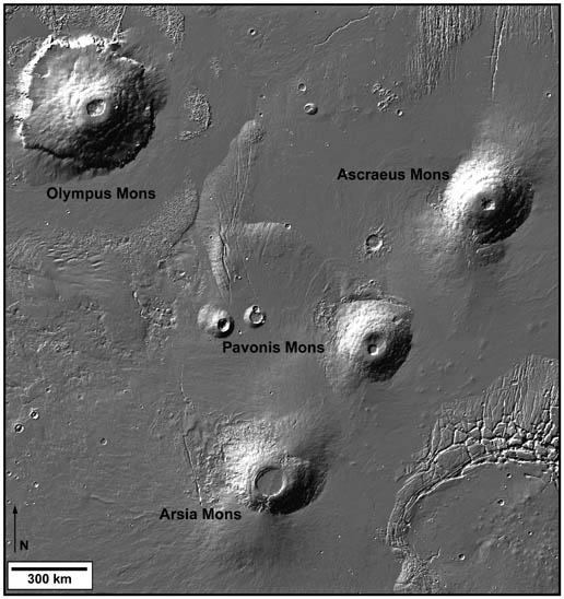
The straight-line layout of these three ancient volcanic structures is though to be created by geologic forces similar to the forces that created the string of islands of Hawaii.
That is, plate tectonics cause a plate to move above a geologic hot-spot under the crust, and as the hot-spot releases pressure onto the crust above, the ever-moving crust slides a bit until the hot-spot once again builds the releases pressure, creating a chain of geologic structures. Mars was once geologically active, and is believed to have had plate tectonics.
Here is an article relating Tharsis Montes to Hawaii:
Hawaii Reveals Steamy Martian Underground
edit on 2016/12/10 by Box of Rain because: fixed picture
new topics
-
President BIDEN's FBI Raided Donald Trump's Florida Home for OBAMA-NORTH KOREA Documents.
Political Conspiracies: 2 hours ago -
Maestro Benedetto
Literature: 4 hours ago -
Is AI Better Than the Hollywood Elite?
Movies: 4 hours ago -
Las Vegas UFO Spotting Teen Traumatized by Demon Creature in Backyard
Aliens and UFOs: 7 hours ago -
2024 Pigeon Forge Rod Run - On the Strip (Video made for you)
Automotive Discussion: 8 hours ago -
Gaza Terrorists Attack US Humanitarian Pier During Construction
Middle East Issues: 9 hours ago -
The functionality of boldening and italics is clunky and no post char limit warning?
ATS Freshman's Forum: 10 hours ago -
Meadows, Giuliani Among 11 Indicted in Arizona in Latest 2020 Election Subversion Case
Mainstream News: 10 hours ago -
Massachusetts Drag Queen Leads Young Kids in Free Palestine Chant
Social Issues and Civil Unrest: 11 hours ago
top topics
-
President BIDEN's FBI Raided Donald Trump's Florida Home for OBAMA-NORTH KOREA Documents.
Political Conspiracies: 2 hours ago, 23 flags -
Krystalnacht on today's most elite Universities?
Social Issues and Civil Unrest: 14 hours ago, 9 flags -
University of Texas Instantly Shuts Down Anti Israel Protests
Education and Media: 16 hours ago, 8 flags -
Weinstein's conviction overturned
Mainstream News: 12 hours ago, 8 flags -
Supreme Court Oral Arguments 4.25.2024 - Are PRESIDENTS IMMUNE From Later Being Prosecuted.
Above Politics: 13 hours ago, 8 flags -
Massachusetts Drag Queen Leads Young Kids in Free Palestine Chant
Social Issues and Civil Unrest: 11 hours ago, 7 flags -
Gaza Terrorists Attack US Humanitarian Pier During Construction
Middle East Issues: 9 hours ago, 7 flags -
Las Vegas UFO Spotting Teen Traumatized by Demon Creature in Backyard
Aliens and UFOs: 7 hours ago, 6 flags -
Meadows, Giuliani Among 11 Indicted in Arizona in Latest 2020 Election Subversion Case
Mainstream News: 10 hours ago, 5 flags -
2024 Pigeon Forge Rod Run - On the Strip (Video made for you)
Automotive Discussion: 8 hours ago, 4 flags
active topics
-
President BIDEN's FBI Raided Donald Trump's Florida Home for OBAMA-NORTH KOREA Documents.
Political Conspiracies • 9 • : WeMustCare -
Supreme Court Oral Arguments 4.25.2024 - Are PRESIDENTS IMMUNE From Later Being Prosecuted.
Above Politics • 85 • : Sookiechacha -
Chris Christie Wishes Death Upon Trump and Ramaswamy
Politicians & People • 24 • : nugget1 -
-@TH3WH17ERABB17- -Q- ---TIME TO SHOW THE WORLD--- -Part- --44--
Dissecting Disinformation • 686 • : Justoneman -
New whistleblower Jason Sands speaks on Twitter Spaces last night.
Aliens and UFOs • 63 • : pianopraze -
SETI chief says US has no evidence for alien technology. 'And we never have'
Aliens and UFOs • 74 • : Justoneman -
Starburst galaxy M82 - Webb Vs Hubble
Space Exploration • 6 • : Arbitrageur -
University of Texas Instantly Shuts Down Anti Israel Protests
Education and Media • 264 • : stelth2 -
VirginOfGrand says hello
Introductions • 9 • : TheMichiganSwampBuck -
Las Vegas UFO Spotting Teen Traumatized by Demon Creature in Backyard
Aliens and UFOs • 10 • : pianopraze