It looks like you're using an Ad Blocker.
Please white-list or disable AboveTopSecret.com in your ad-blocking tool.
Thank you.
Some features of ATS will be disabled while you continue to use an ad-blocker.

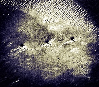
Mars. Three objects at the same distance from each other. The forgotten smoking gun?
page: 2share:
Yes of course nature can make a straight line, but can nature make a triangle?
originally posted by: Box of Rain
Nature can make a straight line.
On Earth, island archipelagos (chains of islands that are often in a straight line) are formed in this manner.

This triangle shape of the three mittens might actually be harder to explain than the straight line:
www.youngsphotogallery.com...
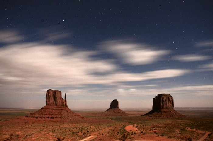
These three buttes are known as the 'Three Mittens': The left one is known as West Mitten Butte, the one in the center is East Mitten Butte, and the one on the right is Merrick Butte. These rise about 1000 feet above the valley floor. This view is looking nearly due east from the visitor center.
I wonder if those three features on Mars are anything like these? There's not enough resolution in the OP photo to tell for sure, nor have I tried to compare the scales.
edit on 2016125 by Arbitrageur because: clarification
Alien, man-made, or natural, I'm just curious to know more about even more possibilities of how in nature something like that could be formed--even
just one of the shapes on it's own... I'm no geologist. The shapes are weird to me. I agree with the others that they look like "vents" but I think
that's stretching it a little.
There are some really odd things here on earth that have been determined to be caused by nature, like the 3 mittens in Arbitrageur's post above, so I wouldn't be surprised if some really neat natural phenomenon caused them.
One way or another, the image is really intriguing to a geological-know-nothing like me.
Heck, maybe it is aliens. Who am I to judge?
edit on 5-12-2016 by servovenford because: typo
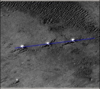
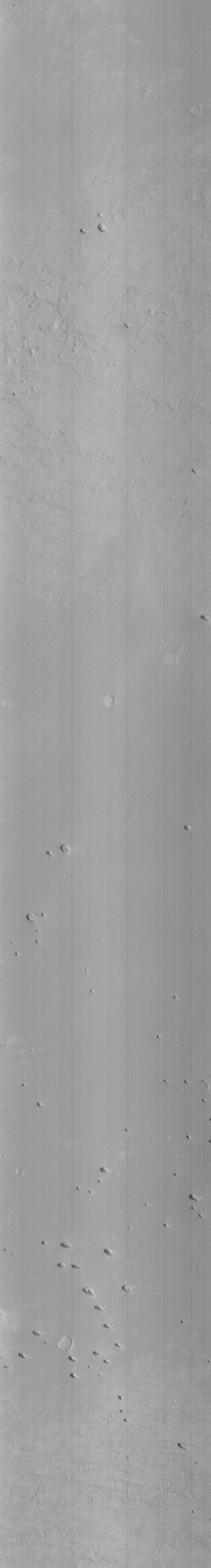
They aren't in straight line, they aren't the same distance apart, they aren't the same shape. I've upped the resolution here to 300 dpi, and the
distances between the centre of each one is 373 and 383 pixels. The black line is one I've added to show that they are not in a straight line.

originally posted by: OneBigMonkeyToo
They aren't in straight line, they aren't the same distance apart, they aren't the same shape. I've upped the resolution here to 300 dpi, and the distances between the centre of each one is 373 and 383 pixels. The black line is one I've added to show that they are not in a straight line.
Not to Knock your effort but the line is set to the bottom of what I assume are shadows.
How does that line look through the centre of the objects?
2001 space odyssey monoliths
whatever they are this is a pretty damn cool find. 10 pixels difference in spacing between the two gaps is close enough. the Egyptian pyramid (the big one) has the speed of light encoded into it... but not exactly... but yet "close enough" to amaze mathematicians, scientists, etc...
The straightness of the alignment is also "close enough" for me.
Close enough for me to find them interesting, that is...
I'm not saying its definitely a group of artificial structures, but, a slight variance in straightness or distance between does not rule out the idea that they might be artificial. Nor does it lessen my interest.
Too bad they were not able to be located using the latest higher quality imagery. Does that mean this area was not photographed by the more recent, high tech sattelites? or does it mean that these features are simply no longer visible in the newer image?
originally posted by: OneBigMonkeyToo
They aren't in straight line, they aren't the same distance apart, they aren't the same shape. I've upped the resolution here to 300 dpi, and the distances between the centre of each one is 373 and 383 pixels. The black line is one I've added to show that they are not in a straight line.
Good work but...If you move the line further up on the picture they are in a straight line? Yes?
Well done Op nice find! Looks like we have alignment.
The objects seem to match as the shadows seem consistent. There appears to be a reflection, which matches the direction of illumination of other rocks.
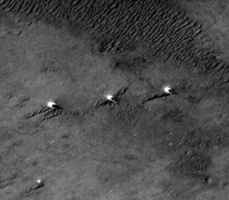
I've circled another potential anomaly here too. Added a few more images which have enhanced the terrain. Wonder what the lineal ripple effect is?
Look carefully at these objects there's a slight more detail here.
The objects seem to match as the shadows seem consistent. There appears to be a reflection, which matches the direction of illumination of other rocks.
I've circled another potential anomaly here too. Added a few more images which have enhanced the terrain. Wonder what the lineal ripple effect is?
Look carefully at these objects there's a slight more detail here.
a reply to: enjoylife
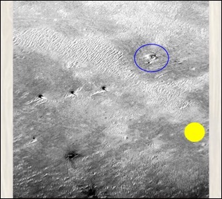
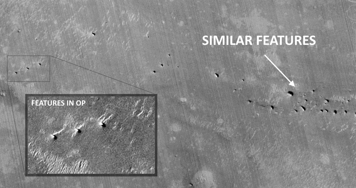
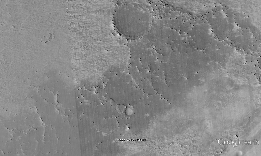
Interesting find. When looking at the context of the terrain, we find similar features nearby (at latitude -0.948897°, longitude -6.773180°). Although there's no HiRISE image available for that particular spot, there is one for an area 8km to the north which also has these kinds of formations (however not so nicely arranged).
Here's some more context:
 Large version
For comparison, a nearby region with similar (hi-res) features:
Large version
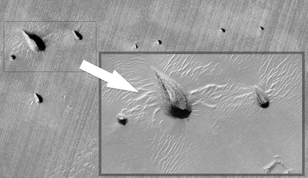
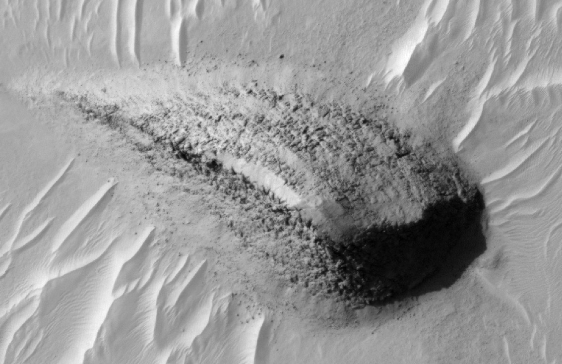
Details of large terrain feature from the image above:

Source CTX
Source HiRISE
Interesting find. When looking at the context of the terrain, we find similar features nearby (at latitude -0.948897°, longitude -6.773180°). Although there's no HiRISE image available for that particular spot, there is one for an area 8km to the north which also has these kinds of formations (however not so nicely arranged).
Here's some more context:
For comparison, a nearby region with similar (hi-res) features:
Large version
Details of large terrain feature from the image above:
Source CTX
Source HiRISE
originally posted by: Misterlondon
What a scientific method you have used there.. That's more like the damp flannel to me..
Perhaps, but the three dots in the image - even the original from the NASA website - are not exactly the same distance apart. They may look it, but where's the science in things looking the same, to them not being the same?
The OP contends the objects are the same distance from each other. They are not. Prove me I am wrong. I have stated my position and even used an unscientific approach, which is the best in hand unless you can suggest otherwise.
a reply to: paraphi
An analyst would have to have the accompanying satellite ephemeris data to know the distance and ratio between the features since it not an exact verticle shot.
I would also like to have a stereo pair under special high powered agency optics for a better analysis.
Only ground truth observation will give the real answers; all the rest is specualtion at best.
edit on 5-12-2016 by lunarcartographer because: (no reason given)
originally posted by: lunarcartographer
I've always thought this was a very interesting set of features that do not look natural based on my experience with cartography, photogrammetry, terrain analysis and imagery analysis in my former career; and in particular mapping the Apollo lunar landing sites.
1) The 'holes' are not a duplicate from stitching, note the surrounding terrain features are different.
2) They are obviously made in the same method.
3) They have equal spacing.
4) Possibly a tower shadow associated with each one, they may be the same height, depending on the slope of the terrain the shadow lies on.
5) They are not craters, crates have an impact rim associated with them.
6) They do not have the appearance, or features, associated with volcanic activity.
Very interesting indeed.
a reply to: enjoylife
Yes number 4 makes it very interesting, look up vents for underground bunkers. May also be pumps or water/other related.
edit on 5-12-2016 by SeaWorthy because: (no reason given)

originally posted by: lunarcartographer
An analyst would have to have the accompanying satellite ephemeris data to know the distance and ratio between the features since it not an exact verticle shot.
Do you mean something like this?
VOLUME_ID - MGSC_1005
FILE_SPECIFICATION_NAME - M00016/M0001661.IMQ
PRODUCT_ID - M00/01661
IMAGE_TIME - 1999-04-11T09:22:31.65
INSTRUMENT_NAME - MOC-NA
FILTER_NAME - N/A
LINE_SAMPLES - 512
LINES - 4864
CROSSTRACK_SUMMING - 2
DOWNTRACK_SUMMING - 2
SCALED_PIXEL_WIDTH - 2.87
PIXEL_ASPECT_RATIO - 1.56
EMISSION_ANGLE - 0.22
INCIDENCE_ANGLE - 42.23
PHASE_ANGLE - 42.20
CENTER_LONGITUDE - 7.04
CENTER_LATITUDE - -1.14
UPPER_LEFT_LONGITUDE - 7.00
UPPER_LEFT_LATITUDE - -1.32
UPPER_RIGHT_LONGITUDE - 7.02
UPPER_RIGHT_LATITUDE - -1.32
LOWER_LEFT_LONGITUDE - 7.05
LOWER_LEFT_LATITUDE - -0.96
LOWER_RIGHT_LONGITUDE - 7.07
LOWER_RIGHT_LATITUDE - -0.96
MISSION_PHASE_NAME - MAPPING
TARGET_NAME - MARS
SPACECRAFT_CLOCK_START_COUNT - 608289774:202
FOCAL_PLANE_TEMPERATURE - 253.0
LINE_EXPOSURE_DURATION - 0.7231
GAIN_MODE_ID - 6A
OFFSET_MODE_ID - 28
EDIT_MODE_ID - 1024
ENCODING_TYPE - MOC-PRED-X-5
SCALED_IMAGE_WIDTH - 1.46
SCALED_IMAGE_HEIGHT - 21.71
SPACECRAFT_ALTITUDE - 381.08
TARGET_CENTER_DISTANCE - 3778.07
SLANT_DISTANCE - 381.08
USAGE_NOTE - N
NORTH_AZIMUTH - 93.03
SUB_SOLAR_AZIMUTH - 36.74
SUB_SOLAR_LONGITUDE - 43.82
SUB_SOLAR_LATITUDE - 20.99
SUB_SPACECRAFT_LONGITUDE - 7.03
SUB_SPACECRAFT_LATITUDE - -1.12
SOLAR_DISTANCE - 239821104.0
SOLAR_LONGITUDE - 122.69
LOCAL_TIME - 14.45
IMAGE_SKEW_ANGLE - 94.3
RATIONALE_DESC - Sample of Terra Meridiani
DATA_QUALITY_DESC - OK
ORBIT_NUMBER - 408
"Do you mean something like this?" Yes - thanks. Then the emphemeris data would be loaded into specific software compatable with high resolution
stereo optical instruments for further analysis and measurements in 3-D.
Even with that advantage, that would likely not settle exactly what the features are to everyone's satisfaction. Only obtaining ground truth would give definative answers; remote viewing with overhead imagery has many advantages but it will only take you so far.
I'm looking forward to the day we put man on the surface for ground truth observations and experiments.
reply to: ArMaP
edit on 5-12-2016 by lunarcartographer because: (no reason given)
edit on 5-12-2016 by lunarcartographer because: (no reason
given)
edit on 5-12-2016 by lunarcartographer because: (no reason given)
originally posted by: lunarcartographer
I've always thought this was a very interesting set of features that do not look natural based on my experience with cartography, photogrammetry, terrain analysis and imagery analysis in my former career; and in particular mapping the Apollo lunar landing sites.
1) The 'holes' are not a duplicate from stitching, note the surrounding terrain features are different.
2) They are obviously made in the same method.
3) They have equal spacing.
4) Possibly a tower shadow associated with each one, they may be the same height, depending on the slope of the terrain the shadow lies on.
5) They are not craters, crates have an impact rim associated with them.
6) They do not have the appearance, or features, associated with volcanic activity.
Very interesting indeed.
a reply to: enjoylife
Exactamundo.
They are spires to Alnitak, Mintaka, amd Alnilam.
a reply to: Brian4real
You're right about that ,before you know it, they'll try to talk it out of your head and that it's a natural cause ..
It's abviously an intelligent crafted rock or whatever it is its very interesting.
You're right about that ,before you know it, they'll try to talk it out of your head and that it's a natural cause ..
It's abviously an intelligent crafted rock or whatever it is its very interesting.
new topics
-
Any one suspicious of fever promotions events, major investor Goldman Sachs card only.
The Gray Area: 51 minutes ago -
God's Righteousness is Greater than Our Wrath
Religion, Faith, And Theology: 5 hours ago -
Electrical tricks for saving money
Education and Media: 8 hours ago -
VP's Secret Service agent brawls with other agents at Andrews
Mainstream News: 9 hours ago -
Sunak spinning the sickness figures
Other Current Events: 10 hours ago -
Nearly 70% Of Americans Want Talks To End War In Ukraine
Political Issues: 10 hours ago
top topics
-
VP's Secret Service agent brawls with other agents at Andrews
Mainstream News: 9 hours ago, 9 flags -
Cats Used as Live Bait to Train Ferocious Pitbulls in Illegal NYC Dogfighting
Social Issues and Civil Unrest: 13 hours ago, 8 flags -
Electrical tricks for saving money
Education and Media: 8 hours ago, 4 flags -
HORRIBLE !! Russian Soldier Drinking Own Urine To Survive In Battle
World War Three: 17 hours ago, 3 flags -
Sunak spinning the sickness figures
Other Current Events: 10 hours ago, 3 flags -
Nearly 70% Of Americans Want Talks To End War In Ukraine
Political Issues: 10 hours ago, 3 flags -
Late Night with the Devil - a really good unusual modern horror film.
Movies: 12 hours ago, 2 flags -
The Good News According to Jesus - Episode 1
Religion, Faith, And Theology: 15 hours ago, 1 flags -
Any one suspicious of fever promotions events, major investor Goldman Sachs card only.
The Gray Area: 51 minutes ago, 1 flags -
God's Righteousness is Greater than Our Wrath
Religion, Faith, And Theology: 5 hours ago, 0 flags
active topics
-
Nearly 70% Of Americans Want Talks To End War In Ukraine
Political Issues • 18 • : gortex -
SETI chief says US has no evidence for alien technology. 'And we never have'
Aliens and UFOs • 56 • : 0bserver1 -
God's Righteousness is Greater than Our Wrath
Religion, Faith, And Theology • 5 • : andy06shake -
HORRIBLE !! Russian Soldier Drinking Own Urine To Survive In Battle
World War Three • 35 • : twistedpuppy -
VP's Secret Service agent brawls with other agents at Andrews
Mainstream News • 42 • : 38181 -
The Acronym Game .. Pt.3
General Chit Chat • 7746 • : bally001 -
Any one suspicious of fever promotions events, major investor Goldman Sachs card only.
The Gray Area • 1 • : BeyondKnowledge3 -
Terrifying Encounters With The Black Eyed Kids
Paranormal Studies • 75 • : FlyersFan -
Russia Ukraine Update Thread - part 3
World War Three • 5728 • : F2d5thCavv2 -
Electrical tricks for saving money
Education and Media • 5 • : BeyondKnowledge3