It looks like you're using an Ad Blocker.
Please white-list or disable AboveTopSecret.com in your ad-blocking tool.
Thank you.
Some features of ATS will be disabled while you continue to use an ad-blocker.

Sandy Island...fact of fantasy
page: 17
share:
Just watched another segment on Sandy Island. It was first charted in 1774. Was shown on maps all through the 1800's. In 2012 Australian scientists
got there only to find nothing! It is said it was then removed from Google maps. On other sites it appears(d) as a blackened or blacked out sea.
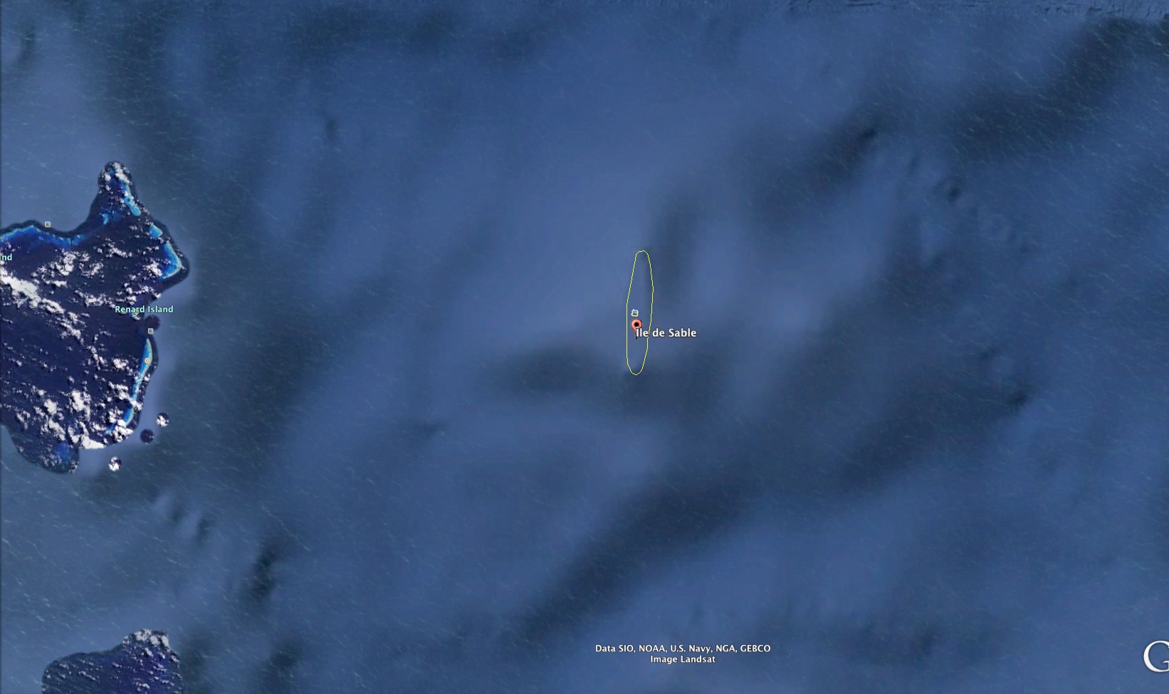
I just checked it out. Put in Sandy Island on Google Maps. It showed up with a yellow outline. I then zoomed in until the line disappeared. Google Maps shows under water terrain all over the globe. What I saw, under where the yellow outline was, is a feature that looks just like the island, same dimensions and all.
I don't know what to make of it other than it's there. There are many theories on it and I haven't a clue as to what it really means, but it is curious. No island on top of water but the feature is there, under the ocean.
Any thoughts would be appreciated.
a reply to: fldinosaur
This is really a lot more common than one might imagine. See the list at Wikipedia - Phantom Island.
This is really a lot more common than one might imagine. See the list at Wikipedia - Phantom Island.
a reply to: fldinosaur
Maybe the island moved in time slightly so that it wasn't visible.
Perhaps there are all sorts of inhabitants that have been "trapped" on the island, not knowing why nothing is out there and no one knows why they haven't been rescued.
Maybe every now and then someone from the other side (our side) ends up arriving via some accidental rip in the "now".
I don't know just a theory.
Did Hurley move it?
Islands apparently appear and vanish all the time.
Islands apparently appear and vanish all the time.
Weird because wiki gives it dimension of about 14x3 miles. Where did they get those numbers if it dosent exist? Does anybody have an old map showing
this island? And if so is it long and skinny as the dimensions suggest.
Nice thread btw, love stuff like this, even though there's probably a natural explanation for it.
Star and flag for you
Nice thread btw, love stuff like this, even though there's probably a natural explanation for it.
Star and flag for you
edit on 6/19/2015 by 772STi because: Star
edit on 6/19/2015 by 772STi because: (no reason
given)
a reply to: fldinosaur
islands go under water I can imagine them reappearing (I THINK).
the earth's tectonic plates around western australia are apparently extremely active . I read ages ago that Albany (and like a quarter of WA) can just break of and go completely under water. totally unpredictable event.
interesting never heard of sandy islands ( i found it in google search like you said, but my maps are saying NO result)
but in many areas you can just walk across the ocean to an island.. in evening you would drown trying to cross back.
a reply to: fldinosaur
Odd, I remembered this island from one of my girlfriends geography textbooks. I will try and find it, but the gist of the section I read talked about how majority of maps are just copied from one another, pre existing ones, and it was basically just a big game of telephone from maybe a few early maps.
But what makes it strange is that it was on google maps, but I checked my world atlas, it's the official national geographic big one, eight edition, and it doesn't have Sandy Island anywhere in it. I honestly think it never existed.
People nowadays think the world has been mapped and charted down to the last square foot. As the hunt for MH370 proved, it certainly hasn't.
In this particular case, we should bear in mind that 'sea level' is not a constant. Apart from the action of the tides, which is predictable and charted, there are also rises and falls in local sea levels due to changes in atmospheric pressure. For low-lying islands and sandbanks, the difference may be enough to make them appear or disappear.
In this particular case, we should bear in mind that 'sea level' is not a constant. Apart from the action of the tides, which is predictable and charted, there are also rises and falls in local sea levels due to changes in atmospheric pressure. For low-lying islands and sandbanks, the difference may be enough to make them appear or disappear.
yup, yup....the T V special showed a seaman with some knowledge of it scanning " no sign of it" on the sea floor....on tv even....
edit
on 19-6-2015 by GBP/JPY because: our new King.....He comes right after a nicely done fake one
a reply to: fldinosaur
Map creators add stuff so they know its their map. If someone tries to copy the map and claim it as their own, the original creator can call BS.
Trap Street
Map creators add stuff so they know its their map. If someone tries to copy the map and claim it as their own, the original creator can call BS.
Trap Street
edit on 20-6-2015 by chucknasty because: added link
a reply to: fldinosaur
lol, it's off the coast of Australia. Or was.....
Wonder if there's other things going on down that way?
lol, it's off the coast of Australia. Or was.....
Wonder if there's other things going on down that way?
"islands" dont go missing unless they get flooded and become submerged
unless they vanish using more advanced technology,
maybe it wasn't ever there or the maps werent accurate
unless they vanish using more advanced technology,
maybe it wasn't ever there or the maps werent accurate
edit on 20-6-2015 by blacktie because: (no reason given)
a reply to: Layaly
I don't know where you read this but it's completely wrong, bits of Western Australia do not just fall off.
The only bits that fall off are small sections of eroded cliff faces, just like anywhere else in the world.
The edge of the tectonic plate along the WA coast is way out to sea and is not very active at all, it is active to the north along side the Indonesian and Mayalsian islands, but the coast of Western Australia is stable and has been for millions of years.
I was born and raised in WA and never heard of any land breaking off.
cheers.
the earth's tectonic plates around western australia are apparently extremely active . I read ages ago that Albany (and like a quarter of WA) can just break of and go completely under water. totally unpredictable event.
I don't know where you read this but it's completely wrong, bits of Western Australia do not just fall off.
The only bits that fall off are small sections of eroded cliff faces, just like anywhere else in the world.
The edge of the tectonic plate along the WA coast is way out to sea and is not very active at all, it is active to the north along side the Indonesian and Mayalsian islands, but the coast of Western Australia is stable and has been for millions of years.
I was born and raised in WA and never heard of any land breaking off.
cheers.
edit on 20/6/2015 by PennyQ because: typo
a reply to: PennyQ
digitalcollections.anu.edu.au...
The tectonic plate on which Australia sits is cracking.
The cruel truth: we're cracking up
Brace for impact. A new fracture zone in the Earth's crust is showing signs of opening up as one of the planet's biggest tectonic plates, the Indo-Australian Plate, on which India and Australia lie, cracks up.
The suspected break crosses the equator near northern Sumatra and extends south-west beneath the Indian Ocean, seismologists say, with the Australian and Indian continents now beginning to shift independently of one another.
m.smh.com.au...
edit on 22-6-2015 by Layaly because: (no reason given)
my opinion is that the " pumice raft " theory is the most plausible and what was spotted by the french surveyor in 1876
new topics
-
Where should Trump hold his next rally
2024 Elections: 2 hours ago -
Shocking Number of Voters are Open to Committing Election Fraud
US Political Madness: 3 hours ago -
Gov Kristi Noem Shot and Killed "Less Than Worthless Dog" and a 'Smelly Goat
2024 Elections: 3 hours ago -
Falkville Robot-Man
Aliens and UFOs: 4 hours ago -
James O’Keefe: I have evidence that exposes the CIA, and it’s on camera.
Whistle Blowers and Leaked Documents: 4 hours ago -
Australian PM says the quiet part out loud - "free speech is a threat to democratic dicourse"...?!
New World Order: 5 hours ago -
Ireland VS Globalists
Social Issues and Civil Unrest: 6 hours ago -
Biden "Happy To Debate Trump"
2024 Elections: 6 hours ago -
RAAF airbase in Roswell, New Mexico is on fire
Aliens and UFOs: 6 hours ago -
What is the white pill?
Philosophy and Metaphysics: 8 hours ago
top topics
-
A Warning to America: 25 Ways the US is Being Destroyed
New World Order: 16 hours ago, 21 flags -
Blast from the past: ATS Review Podcast, 2006: With All Three Amigos
Member PODcasts: 8 hours ago, 13 flags -
James O’Keefe: I have evidence that exposes the CIA, and it’s on camera.
Whistle Blowers and Leaked Documents: 4 hours ago, 12 flags -
Australian PM says the quiet part out loud - "free speech is a threat to democratic dicourse"...?!
New World Order: 5 hours ago, 11 flags -
Biden "Happy To Debate Trump"
2024 Elections: 6 hours ago, 10 flags -
Mike Pinder The Moody Blues R.I.P.
Music: 9 hours ago, 8 flags -
Ireland VS Globalists
Social Issues and Civil Unrest: 6 hours ago, 5 flags -
RAAF airbase in Roswell, New Mexico is on fire
Aliens and UFOs: 6 hours ago, 5 flags -
What is the white pill?
Philosophy and Metaphysics: 8 hours ago, 5 flags -
Putin, Russia and the Great Architects of the Universe
ATS Skunk Works: 12 hours ago, 4 flags
active topics
-
Gov Kristi Noem Shot and Killed "Less Than Worthless Dog" and a 'Smelly Goat
2024 Elections • 29 • : lincolnriley -
Krystalnacht on today's most elite Universities?
Social Issues and Civil Unrest • 11 • : TheWoker -
Remember These Attacks When President Trump 2.0 Retribution-Justice Commences.
2024 Elections • 59 • : TzarChasm -
Salvador Dali's Moustaches
People • 29 • : GENERAL EYES -
Mood Music Part VI
Music • 3111 • : TheWoker -
Where should Trump hold his next rally
2024 Elections • 12 • : StudioNada -
University of Texas Instantly Shuts Down Anti Israel Protests
Education and Media • 310 • : SchrodingersRat -
Candidate TRUMP Now Has Crazy Judge JUAN MERCHAN After Him - The Stormy Daniels Hush-Money Case.
Political Conspiracies • 815 • : Annee -
President BIDEN's FBI Raided Donald Trump's Florida Home for OBAMA-NORTH KOREA Documents.
Political Conspiracies • 35 • : Threadbarer -
2024 Pigeon Forge Rod Run - On the Strip (Video made for you)
Automotive Discussion • 8 • : WhitewaterSquirrel
7