It looks like you're using an Ad Blocker.
Please white-list or disable AboveTopSecret.com in your ad-blocking tool.
Thank you.
Some features of ATS will be disabled while you continue to use an ad-blocker.

The Real S-4
page: 1share:
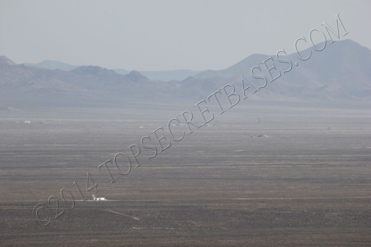
The REAL S-4, not the Papoose Lake/Lazar nonsense. These were taken on my last trip in April, sorry about the graininess and watermark.
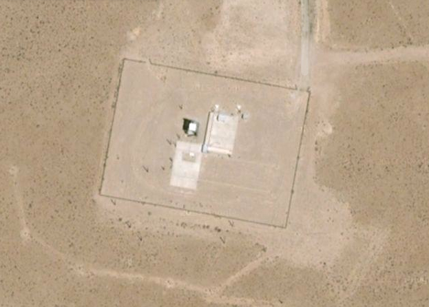
I was at this location:
37.888758°, -116.543409°
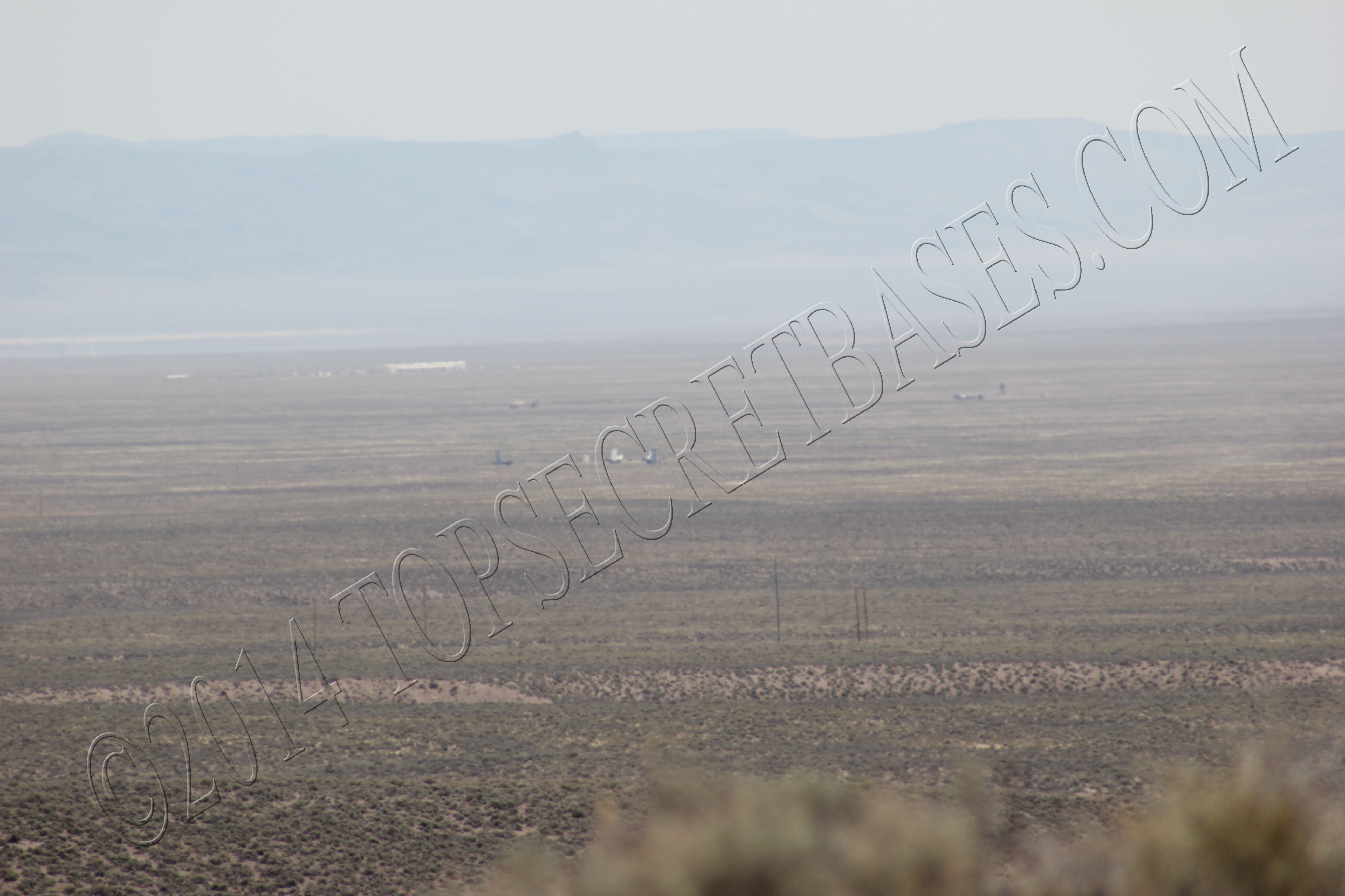
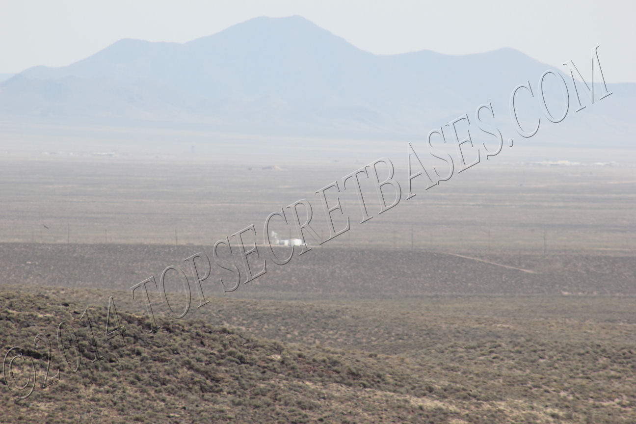
These facilities were roughly south or slightly east of south of my location.
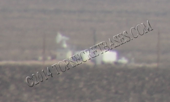
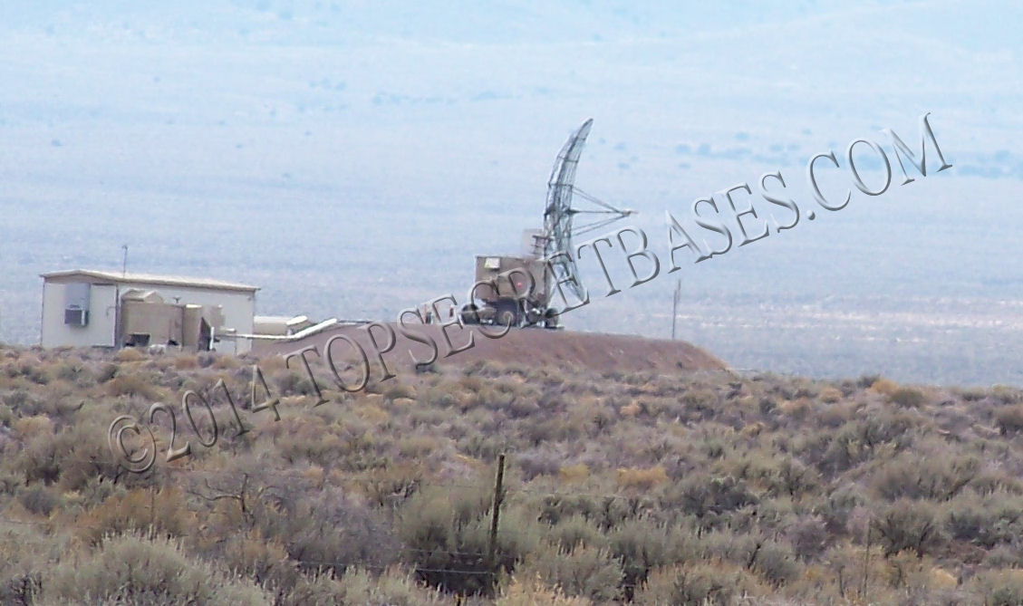
The one that stood out was the "white" one in the foreground, with the white dish. I believe this is at:
37.844403°, -116.516531°
However, if you look at that particular spot on Google Earth, there is a large block that is of very poor resolution. Hmmm.
I don't know specifically which site is S-4, which I believe was/is a radar site from the information I have read. Perhaps gariac or someone else can pinpoint it.
I was at this location:
37.888758°, -116.543409°
These facilities were roughly south or slightly east of south of my location.
The one that stood out was the "white" one in the foreground, with the white dish. I believe this is at:
37.844403°, -116.516531°
However, if you look at that particular spot on Google Earth, there is a large block that is of very poor resolution. Hmmm.
I don't know specifically which site is S-4, which I believe was/is a radar site from the information I have read. Perhaps gariac or someone else can pinpoint it.
edit on 29-5-2014 by FosterVS because: (no reason given)
a reply to: FosterVS
Are you trying to promote something here?
Just curious.....
And first you say
Then you say
How can you make this claim "if you don't know? "
Just saying?
Are you trying to promote something here?
Just curious.....
And first you say
The REAL S-4, not the Papoose Lake/Lazar nonsense. These were taken on my last trip in April, sorry about the graininess and watermark.
Then you say
I don't know specifically which site is S-4, which I believe was/is a radar site from the information I have read. Perhaps gariac or someone else can pinpoint it.
edit on 0569093155659th by LightningStrikesHere because: (no reason given)
How can you make this claim "if you don't know? "
Just saying?
edit on 0589093155859th by LightningStrikesHere because: (no reason given)
a reply to: FosterVS
What, no green-screen, shaky-cam footage?
Google maps
Hmmm… anybody?
What, no green-screen, shaky-cam footage?
Google maps
Hmmm… anybody?
edit on 29-5-2014 by intrptr because: additional
originally posted by: LightningStrikesHere
a reply to: FosterVS
Are you trying to promote something here?
Not promoting anything. Other than the pictures I took. And a not-so-subtle jab at Lazar.
How can you make this claim "if you don't know? "
Just saying?
I know from what I have read, and heard from other people, that S-4/Site-4 is a radar facility in this area. However, if you look at this particular valley with Google Earth, there are many facilities that look to my eyes like radar facilities. This area of the range isn't well documented to my knowledge. Another reason I started this thread and posted the pictures.
For example, at this location are at least 4 spots, N,S,E and W, that appear exactly like radar equipment I have seen and photographed.
37.711532°, -116.432416°
EDITED TO ADD:
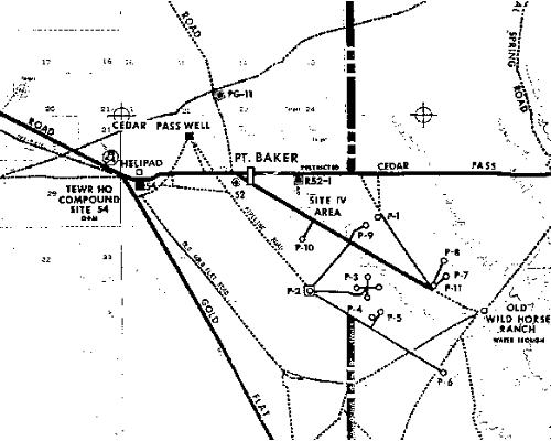
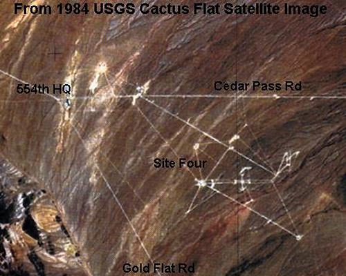
I located these two pictures on the web, that show facility(ies) designated as "Site 4"
edit on 29-5-2014 by FosterVS because: Added picture
edit on 29-5-2014 by FosterVS because: More pictures
edit
on 29-5-2014 by FosterVS because: (no reason given)
originally posted by: LightningStrikesHere
Forgive me it assumed because of the water marks in the picture that you took.a reply to: FosterVS
Well, my pictures have been showing up on other websites, ergo the watermark/shameless plug.
a reply to: FosterVS
You're right. Thats Tonopah missile test range. See the Google Maps link in my post up the page.
Heres an impact site…
google maps
I know from what I have read, and heard from other people, that S-4/Site-4 is a radar facility in this area. However, if you look at this particular valley with Google Earth, there are many facilities that look to my eyes like radar facilities.
You're right. Thats Tonopah missile test range. See the Google Maps link in my post up the page.
Heres an impact site…
google maps
edit on 29-5-2014 by intrptr because: link
originally posted by: FosterVS
originally posted by: LightningStrikesHere
Forgive me it assumed because of the water marks in the picture that you took.a reply to: FosterVS
Well, my pictures have been showing up on other websites, ergo the watermark/shameless plug.
Fair enough
Sorry for my ignorance
originally posted by: FosterVS.
The one that stood out was the "white" one in the foreground, with the white dish. I believe this is at:
37.844403°, -116.516531°
However, if you look at that particular spot on Google Earth, there is a large block that is of very poor resolution. Hmmm.
Bing Maps, however, has a pretty clear view of said white building.

Site-4 is related to "Have Glib". The site had foreign radar with the missiles removed. I assume it has two main tasks. One, the US pilot gets to
learn how to use the aircraft's RWR (radar warning receiver) with real foreign radar. A secondary function is the precision of the foreign radar is
test on US aircraft.
Possibly some of the radar sites are used in fighter weapons school.
The aircraft don't have to be Nellis based. For example, the navy flies over site-4 from their own bases.
Site-4 is difficult to photograph. The sun isn't in a good location, and the area is hazy due to significant water collection.
The site-4 workers use the Janet 737s.
If you try to match photos of SAM sites with what is at site-4, note site-4 generally lacks the associated truck that moves the equipment around, plus the missiles and associated hardware are not mounted.
edit on 30-5-2014 by gariac because: (no reason given)
originally posted by: Rob48
originally posted by: FosterVS.
The one that stood out was the "white" one in the foreground, with the white dish. I believe this is at:
37.844403°, -116.516531°
However, if you look at that particular spot on Google Earth, there is a large block that is of very poor resolution. Hmmm.
Bing Maps, however, has a pretty clear view of said white building.
Doh, jeez and I was the guy that picked up on the fact that Bing had newer Area 51 images that Google Earth.
I should have checked on Bing Maps.
For anyone that cares, I made a Google Earth overlay using the info I could decipher from those maps/images I posted above. You can download it here:
www.topsecretbases.com...
I don't know the vintage of the map, but it looks like there are far more radar facilities in that area now. Assuming that's what they are.
edit on 30-5-2014 by FosterVS because: Added link to KMZ file
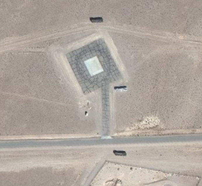
These look a lot like missile trucks to me.
37.711851, -116.443221 on Bing Maps
From Wikimapia:
"Site-4 is part of the TECR or Tonopah Electronic Combat Range. This Range is used by the USAF for Training pilots against Electronic warfare such as Surface-to-Air Missile (SAM) threats, AAA threats and also Electronic Counter Measure and Electronic Support Measure (ECM and ESM) training. Dotted around the base are real threats, including many actual Russian made systems such as SA-6 SAM's, ZSU-23-4 AAA systems and other Russian, Iraqi and Eastern European systems. Site-4 is owned and operated by the 554th Range Squadron, which has its Headquarters located in the center of the site.
Tonopah ECR operates in conjunction with Tolicha Peak ECR (TPECR) located Southwest of TTR. Tonopah ECR as well as Tolicha Peak ECR are also used by Tonopah Test Range, Area 51 and Edwards AFB for testing stealth aircraft against real-time threats such as the foreign systems mentioned above. The Stealth capabilities of the aircraft are tested by flying the aircraft over the threats to see if the enemy radar can detect it.
The SAM and AAA Radar are not the only radar systems to avoid. Also used at the ECR's are EWRS or Early Warning Radar Systems. These are the 'real' threats that in a conflict need to be disabled first, because many EWRS can actually detect Stealth by changing tracking/scanning frequency and modes. These radars can pass information to the smaller targeting radars, to give away the Stealth location, enabling them to make a "kill".
Another use of the ECR sites is during Red Flag. These aerial war-game exercises are operated out of Nellis AFB with some deployments actually operating from the TTR base itself. During Red Flag, U.S. and allied pilots are trained in extremely realistic aerial combat situations, including the enemy systems of the ECRs."
edit on 30-5-2014 by FosterVS because: (no reason given)
edit on 30-5-2014 by FosterVS because:
(no reason given)
while in the Army... I was a clerk in an S-2 (Battalion level security & intel/maps/crypto/recon/ section)...
I had frequent and sensitive (ongoing) links with both G-2 (Division level) & NATO, USAREUR, et al...
the only S-4 I ever run across was 'SUPPLY' which issued bed linens and also stored our Weapons in the Armory they controlled....
the whole thing about a secret "S-4" at the Area 51 place is a bunch of glorified rot-gut, contrived by a great Yarn-Spinner/ Story Teller...
that's the personal perspective I have had for more than 40 years of hearing this drivel from some self-acclaimed authority and In-The-Know Insider
edit on th31140149884130142014 by St Udio because: (no reason given)
originally posted by: gariac
Site-4 is related to "Have Glib". The site had foreign radar with the missiles removed. I assume it has two main tasks. One, the US pilot gets to learn how to use the aircraft's RWR (radar warning receiver) with real foreign radar. A secondary function is the precision of the foreign radar is test on US aircraft.
Possibly some of the radar sites are used in fighter weapons school.
The aircraft don't have to be Nellis based. For example, the navy flies over site-4 from their own bases.
Site-4 is difficult to photograph. The sun isn't in a good location, and the area is hazy due to significant water collection.
The site-4 workers use the Janet 737s.
If you try to match photos of SAM sites with what is at site-4, note site-4 generally lacks the associated truck that moves the equipment around, plus the missiles and associated hardware are not mounted.
Do they fly into tonapah on the Janet's or is there another airfield around s-4?
originally posted by: boomer135
originally posted by: gariac
Site-4 is related to "Have Glib". The site had foreign radar with the missiles removed. I assume it has two main tasks. One, the US pilot gets to learn how to use the aircraft's RWR (radar warning receiver) with real foreign radar. A secondary function is the precision of the foreign radar is test on US aircraft.
Possibly some of the radar sites are used in fighter weapons school.
The aircraft don't have to be Nellis based. For example, the navy flies over site-4 from their own bases.
Site-4 is difficult to photograph. The sun isn't in a good location, and the area is hazy due to significant water collection.
The site-4 workers use the Janet 737s.
If you try to match photos of SAM sites with what is at site-4, note site-4 generally lacks the associated truck that moves the equipment around, plus the missiles and associated hardware are not mounted.
Do they fly into tonapah on the Janet's or is there another airfield around s-4?
They fly into KTNX
originally posted by: weavty1
originally posted by: boomer135
originally posted by: gariac
Site-4 is related to "Have Glib". The site had foreign radar with the missiles removed. I assume it has two main tasks. One, the US pilot gets to learn how to use the aircraft's RWR (radar warning receiver) with real foreign radar. A secondary function is the precision of the foreign radar is test on US aircraft.
Possibly some of the radar sites are used in fighter weapons school.
The aircraft don't have to be Nellis based. For example, the navy flies over site-4 from their own bases.
Site-4 is difficult to photograph. The sun isn't in a good location, and the area is hazy due to significant water collection.
The site-4 workers use the Janet 737s.
If you try to match photos of SAM sites with what is at site-4, note site-4 generally lacks the associated truck that moves the equipment around, plus the missiles and associated hardware are not mounted.
Do they fly into tonapah on the Janet's or is there another airfield around s-4?
They fly into KTNX
While you two know KTNX, for those that don't know, KTNX is the ICAO (International Civil Aviation Organization) code for the Tonopah Test Range. But to add to confusion, flights to Groom Lake use KTNX as their destination as well since Groom Lake technically doesn't exist. [It is occasionally listed at TKM. In the Honeywell database, Groom Lake is known as KXTA) .
There is a dirt airstrip (Mellan) near Site-4, but they don't use it much if at all. The Keno airstrip replaced it as far as Red Flag goes.
"Have Glib" is one tough project to search on the internet since "have" is a common word and "Glib" is part of gnome (Linux). There is some official information about "Have Glib" here:
CIA documents
"Have Glib" was originally (and still might be) a Groom Lake project. Much like the Migs started at Groom Lake and then went to the TTR, so did Have Glib. It is briefly mentioned in the Roadrunners newsletter:
Search for have glib
I see a Janet filed today (Saturday 5/31/2014). Saturday flights used to be rare, at least for the 737s.
Saturday flight
This flight was to Groom, not the TTR.
I have to presume they are keeping the tower personnel overnight at Groom so that the 737 can land, or they fly the tower staff to the base in a Beech just to land the 737. After the Beech crash a few years ago, uncontrolled landings are kept to a minimum. As far as I know, only the tower staff flies without a controller.
Well you don't need someone in the tower for an aircraft to land. Maybe a little different for the Janet's but we had other airfields we did touch
and gos on and the tower at our home base controlled that runway about ten mikes away most of the time. It has a state of the art tower there too, and
it was rarely used.
a reply to: boomer135
The USAF handles flights that are primarily for civilians differently than military flights. You may recall after the CT-43 crash in Croatia, the CT series planes got dual VOR capability, like their civilian counterpart. After the JT3 crash, flights carrying civilians became restricted at unattended towers. (Of course, civilians can land at unattended towers at their own liability. It is done all the time. That airport at Jean, just west of Vegas, is a prime example of a busy unattended airport.)
I have scanner audio of one of the DOE aircraft landing at the TTR without controllers. Nellis control gave them special permission and a notice that they were on their own.
This hybrid civilian/military air traffic control is tricky to figure out. Nellis control is done by military ATC. Edwards "SPORT" is civilian. One of the easiest ways to see who does what is to find photographs of the controllers. If they are in camo, it is a military operation.
It could all come down to if the planes have civilian insurance or if they are DoD self insured. [I doubt any commercial company would insure a fighter aircraft used in a war zone.]
a reply to: gariac
I wish people would stop saying that TTR Site 4 and the Groom Lake radar complex are associated with HAVE GLIB as if this were a well established fact. We really have no strong supporting evidence for this theory. Over the last several years it has become abundantly clear, through declassified documents and interviews with former test personnel, that project HAVE GLIB was at least started as an umbrella program for the exploitation of MiG-17 and MiG-21 aircraft in the early 1970s. This preceded HAVE IDEA, which was established in 1973. Various sub-projects under HAVE IDEA carried their own separate identities such as HAVE DRY (MiG-21 vs. F-15), HAVE PAD (MiG-23),and many others.
Confusion arises from the fact that HAVE GLIB did not end when HAVE IDEA began. In fact, it continued until at least the early 1980s. The only circumstantial connection between HAVE GLIB and the evaluation of foreign threat radar systems is the fact that some of that type of equipment northwest of Groom Lake is located along "Glib Road." Frankly, that is the only reason I made such an assumption. I posted my theory on the Internet - rather more assertively than was warranted - and have since been surprised at how it has come to be considered gospel. It may indeed be true that HAVE GLIB came to encompass the radar program after HAVE IDEA became the umbrella for MiG exploitation, but I have yet to confirm that from any source.
new topics
-
Maestro Benedetto
Literature: 1 hours ago -
Is AI Better Than the Hollywood Elite?
Movies: 1 hours ago -
Las Vegas UFO Spotting Teen Traumatized by Demon Creature in Backyard
Aliens and UFOs: 4 hours ago -
2024 Pigeon Forge Rod Run - On the Strip (Video made for you)
Automotive Discussion: 5 hours ago -
Gaza Terrorists Attack US Humanitarian Pier During Construction
Middle East Issues: 6 hours ago -
The functionality of boldening and italics is clunky and no post char limit warning?
ATS Freshman's Forum: 7 hours ago -
Meadows, Giuliani Among 11 Indicted in Arizona in Latest 2020 Election Subversion Case
Mainstream News: 7 hours ago -
Massachusetts Drag Queen Leads Young Kids in Free Palestine Chant
Social Issues and Civil Unrest: 7 hours ago -
Weinstein's conviction overturned
Mainstream News: 9 hours ago -
Supreme Court Oral Arguments 4.25.2024 - Are PRESIDENTS IMMUNE From Later Being Prosecuted.
Above Politics: 10 hours ago
top topics
-
Krystalnacht on today's most elite Universities?
Social Issues and Civil Unrest: 10 hours ago, 9 flags -
Supreme Court Oral Arguments 4.25.2024 - Are PRESIDENTS IMMUNE From Later Being Prosecuted.
Above Politics: 10 hours ago, 8 flags -
University of Texas Instantly Shuts Down Anti Israel Protests
Education and Media: 13 hours ago, 7 flags -
Weinstein's conviction overturned
Mainstream News: 9 hours ago, 7 flags -
Gaza Terrorists Attack US Humanitarian Pier During Construction
Middle East Issues: 6 hours ago, 7 flags -
Massachusetts Drag Queen Leads Young Kids in Free Palestine Chant
Social Issues and Civil Unrest: 7 hours ago, 6 flags -
Meadows, Giuliani Among 11 Indicted in Arizona in Latest 2020 Election Subversion Case
Mainstream News: 7 hours ago, 5 flags -
Las Vegas UFO Spotting Teen Traumatized by Demon Creature in Backyard
Aliens and UFOs: 4 hours ago, 4 flags -
2024 Pigeon Forge Rod Run - On the Strip (Video made for you)
Automotive Discussion: 5 hours ago, 2 flags -
Any one suspicious of fever promotions events, major investor Goldman Sachs card only.
The Gray Area: 15 hours ago, 2 flags
active topics
-
Nearly 70% Of Americans Want Talks To End War In Ukraine
Political Issues • 94 • : Scratchpost -
University of Texas Instantly Shuts Down Anti Israel Protests
Education and Media • 229 • : Station27 -
VP's Secret Service agent brawls with other agents at Andrews
Mainstream News • 62 • : ByeByeAmericanPie -
SETI chief says US has no evidence for alien technology. 'And we never have'
Aliens and UFOs • 72 • : yuppa -
My Poor Avocado Plant.
General Chit Chat • 77 • : JonnyC555 -
New whistleblower Jason Sands speaks on Twitter Spaces last night.
Aliens and UFOs • 61 • : Ophiuchus1 -
Is AI Better Than the Hollywood Elite?
Movies • 2 • : 5thHead -
Gaza Terrorists Attack US Humanitarian Pier During Construction
Middle East Issues • 25 • : CarlLaFong -
Mood Music Part VI
Music • 3102 • : Hellmutt -
Las Vegas UFO Spotting Teen Traumatized by Demon Creature in Backyard
Aliens and UFOs • 9 • : Ophiuchus1