It looks like you're using an Ad Blocker.
Please white-list or disable AboveTopSecret.com in your ad-blocking tool.
Thank you.
Some features of ATS will be disabled while you continue to use an ad-blocker.

Landslide In Washington Ongoing efforts to find survivors
page: 2share:
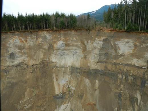
An aerial photo provided by the Washington State Department of Transportation shows where a hillside let loose high above the Stillaguamish River, sending thousands of tons of debris down into the valley.
www.nbcnews.com...
Dept. of Emergency Mgmt says water coming out from landslide dam is normal, people in "good situation tonight."
Mp3 audio of last press conference:
www.dropbox.com...
Well, so it looks like the threat of the dam breaking is not so much a threat. Uh huh. And the air was safe to breathe after 9/11, too. Righto.
Mp3 audio of last press conference:
www.dropbox.com...
Well, so it looks like the threat of the dam breaking is not so much a threat. Uh huh. And the air was safe to breathe after 9/11, too. Righto.
reply to post by westcoast
the river isnt completely stopped, it has had flow during the whole event but it was very slowed and mostly blocked, the blockage passage the water has found is showing signs of growing larger and relieving pressure, this hydro-graph is just downstream of the blockage water.weather.gov... you can see the water level is picking back up rapidly, all that pressure is forcing the opening to grow wider. the point in the graph where the water level takes a dip is right when the landslide occurred.
looking at satellite photos of the area before the landslide occurred you can clearly see that exact spot has far less vegetation then the surrounding areas. which of course increases landslide risk significantly, im wondering why it has less vegetation, is it just naturally bare there? or was it perhaps all chopped down to be sold for timber?
edit on 3/23/14 by pryingopen3rdeye because: (no reason given)
Thank you much for this members, and to members in the area, stay safe and sending regards.
On the topic of not much in the news, and finding that this is more devastating than I had thought: Being on the other side of the state's area, there doesn't seem to be much about this. Found shared locally in the Inland NW, except the local news sharing from King5 / AP.
Video also shares about missing persons.
REUNIFICATION, EVACUATION AND SHELTER INFORMATION: 425-388-5088
If you are directly impacted by the slide you can register on the Red Cross website safeandwell.org so family and friends will know you are OK. Source
This isn't the first mud slide like this in Washington, but this one has probably affected the most people. Unfortunately, due to the hilly and wet
nature of our state combined with rapid population growth and development, I think eventually things like this will be a regular occurrence.
reply to post by pryingopen3rdeye
I looked at and read the link you provided, can you break it down so I can understand a bit clearer what it is I am looking at and how these graphs affect the people in the direct line of this potential flood plain and the rescue attempts?
I looked at and read the link you provided, can you break it down so I can understand a bit clearer what it is I am looking at and how these graphs affect the people in the direct line of this potential flood plain and the rescue attempts?
reply to post by TrueAmerican
Are they down playing this so that the separation of communities begins in earnest for the tragic days ahead? Desensitization and marginalizing numbers unless it deals with economics?
Are they down playing this so that the separation of communities begins in earnest for the tragic days ahead? Desensitization and marginalizing numbers unless it deals with economics?
My prayers go out to all and everyone affected by this tonight. I feel similar tonight to how I felt on the late morning of 911. Helpless, validated
for that feeling that kept me off all day. Just heartbroken for the pain and stress this is causing so many people directly affected and even
trapped trying to stay alive until help arrives.
antar
reply to post by TrueAmerican
Are they down playing this so that the separation of communities begins in earnest for the tragic days ahead? Desensitization and marginalizing numbers unless it deals with economics?
I dunno, but how an emergency management official can get up to a podium and claim "we're in a good situation tonight" after at least 8 are dead, many still missing, many evacuated and out of their homes, and families hurting like hell- is way beyond me.
I'm surprised they haven't sent in the national guard to confiscate all the guns yet.
edit on Mon Mar 24th 2014 by TrueAmerican because: (no
reason given)
pryingopen3rdeye
reply to post by westcoast
the river isnt completely stopped, it has had flow during the whole event but it was very slowed and mostly blocked, the blockage passage the water has found is showing signs of growing larger and relieving pressure, this hydro-graph is just downstream of the blockage water.weather.gov... you can see the water level is picking back up rapidly, all that pressure is forcing the opening to grow wider. the point in the graph where the water level takes a dip is right when the landslide occurred.
looking at satellite photos of the area before the landslide occurred you can clearly see that exact spot has far less vegetation then the surrounding areas. which of course increases landslide risk significantly, im wondering why it has less vegetation, is it just naturally bare there? or was it perhaps all chopped down to be sold for timber?edit on 3/23/14 by pryingopen3rdeye because: (no reason given)
Do you have any links to articles confirming this?
I was going off initial reports, that the riverbed beyond the dam was basically dry. It started to have a small breach earlier today and they were afraid it might grow but t seems to be holding steady. It is, as far as all reports I have read and heard, blocked. The latest now is that the river is diverting itself around the slide, and started flowing again a bit downstream. Maybe that is where the increase is coming from. Either way, I don't care...I'm just glad that its finding a away around or through.
TA...I think that ground saturation is being blamed. However, I know there was a smallish slide there back in 2006 and there has since been concern of a larger slide happening, but there was apparently no warning to this. There is also talk of maybe some mismanagement with development/logging, but that is hearsay.
I honestly don't know why the info is being subdued. The local tally for the missing is WELL over 30 now and still growing, yet the news is still saying 18. The list I posted earlier (with pictures) is as easily available to them as it is me. It has been compiled by information sent directly from family members, so it is not speculation.
Ulterior motives, and the media silence. Indeed why is it so quite? If this happened in let's say Upstate NY, it would be top news(not that I
wouldn't want it to be my family lives there) but is it due to "less media worthy areas" or something more? Further more the Pac NW's mostly
"ignoring" the tragedy. That's concerning in itself.
MSM wise, the most common image you see of the street blocked by debris, that was taken by state patrol and asked for permission to use by media(ABC originally I think?), which is mostly shared. CNN as a couple hours ago says "...more than a dozen unaccounted for". As shared, it's way more missing people than a dozen! Playing it down much? Wow...
Gun confiscation, good point. Would it be a trial run? Let them try the culture up this way possibly isn't going to let anything like that happen? I am concerned for that Wash. State however did pass a gun law lately, See this. Anymore in the works, or as mentioned using tragedy for trial?
reply to post by dreamingawake
No...I wouldn't say that It has anything to do with gun control.
Local news is running continuous stories on it, and it made the front page of MSM...it's just that its the same recycled info that is lacking in some pretty BIG details.
There has been a state of emergency declared, I believe this morning...yet, as far as I know National Guard has not been deployed. I don't think they had helicopters searching for awhile and didn't move hover craft in until this afternoon. I know its a fluid situation and unique In its scope, so its hard to know what to do.
The local EMS response was amazing and their dedication to stay on scene and risks their lives is hard to grasp. Its just so massive that the logistics involved in the search is hard to comprehend.
Hi Westcoast,
Glad to hear you are OK.
This is a terrible thing, and I agree with everyone, that this should be front and center in the news.
I remember a story a while back about the NSA getting comfpy/cozy and moving in on the news media. I really wonder if they are not calling the shots on whether this should be put out there.
American's are scared as a whole right now. With all the problems we have domesticly now. And then there's that little spat with Putin.
Maybe there really trying to control our anietly level.
antar
reply to post by pryingopen3rdeye
I looked at and read the link you provided, can you break it down so I can understand a bit clearer what it is I am looking at and how these graphs affect the people in the direct line of this potential flood plain and the rescue attempts?
the link shows the water level downstream of the same river experiencing the blockage which is upstream from the device giving those readings, it shows the effects the landslide had in lowering the water level of the river, and it shows that the same river is now gaining water level rapidly, this would indicate the water is finding its way through the blockage in increasing volume as time goes by. which to my own opinion indicates the risk of a sudden burst is a decreasing risk,
westcoast
Do you have any links to articles confirming this?
The latest now is that the river is diverting itself around the slide, and started flowing again a bit downstream. Maybe that is where the increase is coming from.
i suppose i shouldnt say through the blockage when around the blockage is just as reasonable of a statement, same meaning in my eyes really.
I know there was a smallish slide there back in 2006
yes actually it was the exact same mass that slid in 2006, it only moved a few feet which is significant but nothing compared to whats happened now, in hindsight that 2006 movement was clearly a foreshadowing of this event.
I honestly don't know why the info is being subdued. The local tally for the missing is WELL over 30 now and still growing, yet the news is still saying 18. The list I posted earlier (with pictures) is as easily available to them as it is me. It has been compiled by information sent directly from family members, so it is not speculation.
i dont know why either but a guess could be the media is only reporting a tally they themselves have confirmed to be missing individuals, and all others reported missing the media may think they were just not at home when this occurred and just have not reported in their well being yet, perhaps the media wants to confirm those others themselves before adding them to the tally, perhaps the media hasnt been able to contact the relevant family members to achieve said confirmation of missing, even if that were the case i would expect them to be on top of it and if that is the case then clearly they are slacking in that effort, either way its what we've all come to expect from main stream media, incompetence.
edit on 3/24/14 by
pryingopen3rdeye because: (no reason given)
reply to post by westcoast
Thanks for the reply and for the continuing info, as it's harder to find in my area.
Thanks for the reply and for the continuing info, as it's harder to find in my area.
pryingopen3rdeye
yes actually it was the exact same mass that slid in 2006, it only moved a few feet which is significant but nothing compared to whats happened now, in hindsight that 2006 movement was clearly a foreshadowing of this event.
Oh great. Now we have foreslides, in addition to foreshocks. Let's hope the same doesn't apply to the Cumbre Viejo volcano which already slid some 6 feet down hill, causing that massive crack. Cause we all know the outcome of THAT if it decides to finish sliding all at once. East coast USA tsunami. Cya Florida.
Took you all over 24 hours to pay attn even though it was posted in Fragile Earth yesterday. The OP didn't do much follow up so I suppose that
should be expected. National news only started giving details a day later.
I've been following links that I posted yesterday in the first OP. It has been bad. I went to bed last hearing that there was 3 confirmed dead, 8 in the hospital (one died later), 6 destroyed homes and that rescue workers could hear victims calling out for help but the environment was too unstable for rescue efforts to continue. --I was crying as I went to bed because reports where out that they could hear a child and an animal trapped (along with others cries for help) but they couldn't get to them. I woke up to find out that there were no more cries for help, no more signs of life. I hope that isn't true.
I've not been listening/reading as much during the last 12 hours. I experienced something terrible in my old hometown in 2011 and I was feeling some rather raw emotions and I had to turn off media for awhile. But, I did look a couple of hours ago and saw that the death count had doubled. I am just not capable of imagining what the affected families are feeling right now let alone trying to what the victims themselves might be experiencing.
I've been told that the hill involved has had a mudslide in the past. And, that only a couple of years ago that the State worked on securing the area against another slide when it was noted that Highway 530 was buckling because the land was slipping. The State said that the repairs were permanent. I've also heard complaints of bad logging practices in that area. Clearcutting. I understand the idea but I'm not sure how about the actual real life effects. I live in Sno county and have been dealing with flooding at my own home due to the county not maintaining proper drainage. So, I look upon the county with some suspicion on its ability to evaluate and act appropriately to long term risks.
My heart is aching for the people in that neighborhood.
reply to post by westcoast
So glad that you are safe Westcoast. Just saw this on Australian news and thought of you instantly. Terribly sad and shocking. Thoughts and prayers to those lost and affected by the disaster.
So glad that you are safe Westcoast. Just saw this on Australian news and thought of you instantly. Terribly sad and shocking. Thoughts and prayers to those lost and affected by the disaster.
Dianec
I hadn't heard of this until now and it's truly heartbreaking that they are hearing voices but cannot find them. If it's that soft the ground will suffocate them so I hope they don't slow down their efforts. Perhaps they can hang from helicopters or somehow reinforce the ground just long enough to get more time. What a nightmare.
It's because the rescuers have to stop if it's not safe for them. They were sinking into the mud and needed pulling out themselves. By today the sounds had stopped.
It's heartbreaking.
Last I heard it was 8 deaths, 16 missing.
TrueAmerican
pryingopen3rdeye
yes actually it was the exact same mass that slid in 2006, it only moved a few feet which is significant but nothing compared to whats happened now, in hindsight that 2006 movement was clearly a foreshadowing of this event.
Oh great. Now we have foreslides, in addition to foreshocks. Let's hope the same doesn't apply to the Cumbre Viejo volcano which already slid some 6 feet down hill, causing that massive crack. Cause we all know the outcome of THAT if it decides to finish sliding all at once. East coast USA tsunami. Cya Florida.
Foreslides. That's an interesting Segway into a tsunami in Florida.
No such thing though.
It's very wet ground here. Mountainous region. Landslides and avalanches are unfortunately common.
As a geologist you must know this
new topics
-
Putin, Russia and the Great Architects of the Universe
ATS Skunk Works: 49 minutes ago -
A Warning to America: 25 Ways the US is Being Destroyed
New World Order: 5 hours ago -
President BIDEN's FBI Raided Donald Trump's Florida Home for OBAMA-NORTH KOREA Documents.
Political Conspiracies: 10 hours ago
top topics
-
President BIDEN's FBI Raided Donald Trump's Florida Home for OBAMA-NORTH KOREA Documents.
Political Conspiracies: 10 hours ago, 28 flags -
A Warning to America: 25 Ways the US is Being Destroyed
New World Order: 5 hours ago, 10 flags -
Gaza Terrorists Attack US Humanitarian Pier During Construction
Middle East Issues: 17 hours ago, 8 flags -
Las Vegas UFO Spotting Teen Traumatized by Demon Creature in Backyard
Aliens and UFOs: 16 hours ago, 7 flags -
2024 Pigeon Forge Rod Run - On the Strip (Video made for you)
Automotive Discussion: 16 hours ago, 4 flags -
Is AI Better Than the Hollywood Elite?
Movies: 12 hours ago, 3 flags -
Maestro Benedetto
Literature: 12 hours ago, 1 flags -
Putin, Russia and the Great Architects of the Universe
ATS Skunk Works: 49 minutes ago, 1 flags
active topics
-
What in the S.E.O. hell is this?
General Chit Chat • 27 • : reannamurphy -
Putin, Russia and the Great Architects of the Universe
ATS Skunk Works • 7 • : RussianTroll -
"We're All Hamas" Heard at Columbia University Protests
Social Issues and Civil Unrest • 286 • : FlyersFan -
A Warning to America: 25 Ways the US is Being Destroyed
New World Order • 9 • : Lazy88 -
President BIDEN's FBI Raided Donald Trump's Florida Home for OBAMA-NORTH KOREA Documents.
Political Conspiracies • 21 • : CriticalStinker -
SETI chief says US has no evidence for alien technology. 'And we never have'
Aliens and UFOs • 75 • : Hecate666 -
Las Vegas UFO Spotting Teen Traumatized by Demon Creature in Backyard
Aliens and UFOs • 13 • : FlyersFan -
Mood Music Part VI
Music • 3105 • : BrucellaOrchitis -
The Acronym Game .. Pt.3
General Chit Chat • 7752 • : bally001 -
Is AI Better Than the Hollywood Elite?
Movies • 18 • : Hecate666