It looks like you're using an Ad Blocker.
Please white-list or disable AboveTopSecret.com in your ad-blocking tool.
Thank you.
Some features of ATS will be disabled while you continue to use an ad-blocker.

The Best Flight 370 Scenario So Far - Theory of an actual pilot
page: 19share:
Nochzwei
sy.gunson
Nochzwei
Not even one of The several ELts did not sing at all.
So no crash. Period
ELT locators are radio beacons. Where the aircraft is located now is under 26,000ft of water. Radio does not transmit through water.
It is definitely not in the water. Take it from me.
Elts trigger on a crash due to G forces
the plane spots something the boats go there 2/3 days later and debris has moved on.
why are they not using hover craft or better still FLYING BOATS?
A flying boat is a plane that flies and can also go like a boat.look in google images.
invented last century.
also you can refuel them from any sea going ship.
so they can over large distances and go immediately to any debris.they can spot debris and land right next to it in the water.
at the moment you have the absurd situation a plane spots something but can't identify it or bring it on board.
by the the time the boats/ships gets there it has has drifted away.
what do you think and how can we inform the search people about this?
reply to post by championoftruth
Because the flying boasts in use are small single engine types with floats attached where the landing gear are. They couldn't get anywhere remotely close to where the debris is.
Because the flying boasts in use are small single engine types with floats attached where the landing gear are. They couldn't get anywhere remotely close to where the debris is.
Zaphod58
reply to post by championoftruth
Because the flying boasts in use are small single engine types with floats attached where the landing gear are. They couldn't get anywhere remotely close to where the debris is.
The ShinMaywa US-2 is a large STOL amphibious aircraft designed for air-sea rescue work. The US-2 is operated by the Japan Maritime Self Defense Force.
The Canadair CL-215 and successor Bombardier 415 are examples of modern flying boats and are used for forest fire suppression.
Many modern seaplane variants, whether float or flying boat types, are convertible amphibian aircraft where either landing gear or flotation modes may be used to land and take off.
edit on 26-3-2014 by championoftruth because: (no reason given)
championoftruth
Nochzwei
sy.gunson
Nochzwei
Not even one of The several ELts did not sing at all.
So no crash. Period
ELT locators are radio beacons. Where the aircraft is located now is under 26,000ft of water. Radio does not transmit through water.
It is definitely not in the water. Take it from me.
Elts trigger on a crash due to G forces
the plane spots something the boats go there 2/3 days later and debris has moved on.
why are they not using hover craft or better still FLYING BOATS?
A flying boat is a plane that flies and can also go like a boat.look in google images.
invented last century.
also you can refuel them from any sea going ship.
so they can over large distances and go immediately to any debris.they can spot debris and land right next to it in the water.
at the moment you have the absurd situation a plane spots something but can't identify it or bring it on board.
by the the time the boats/ships gets there it has has drifted away.
what do you think and how can we inform the search people about this?
Heck. Looks like the search authorities are spinning some hoax objects scenario and all the media is swallowing it without any Intelligent thought. Not to mention the ongoing mock search operations.
Doesn't smell right, does it?
sy.gunson
I'm a pilot.
An aircraft entering the water at 450+ knots is underwater before there is any worthwhile transmission.
Well if is definitely not in the water provide credible proof, not theories.
So am I
Don't agree
Proof will emerge .BTW Where is your theory and Credible proof?
so tit for tat there.....for crying out loud
reply to post by championoftruth
Neither of which has anywhere near the range to reach the search area without modification to add fuel tanks, which reduces the number of people and cargo they can carry.
The US-2 has a 2500 mile range, and the CL-215 has a 2200 mile range. The 415 is even less.
Neither of which has anywhere near the range to reach the search area without modification to add fuel tanks, which reduces the number of people and cargo they can carry.
The US-2 has a 2500 mile range, and the CL-215 has a 2200 mile range. The 415 is even less.
edit on 3/26/2014 by Zaphod58 because: (no reason
given)
championoftruth
The ShinMaywa US-2 is a large STOL amphibious aircraft designed for air-sea rescue work. The US-2 is operated by the Japan Maritime Self Defense Force.
This aircraft has a range of 2,900m and is not mid-air refuelable. It would not be able to travel to the search area and return if it landed.
The Canadair CL-215 and successor Bombardier 415 are examples of modern flying boats and are used for forest fire suppression.
This aircraft has a range of 1,500m, is also not mid-air refuelable and would barely make a one way trip to the search area.
Many modern seaplane variants, whether float or flying boat types, are convertible amphibian aircraft where either landing gear or flotation modes may be used to land and take off.
None of which have the range or refueling capacity. People need to realize how remote this portion of the earth is and that no one ventures there on a regular basis because there is nothing there.
AugustusMasonicus
championoftruth
The ShinMaywa US-2 is a large STOL amphibious aircraft designed for air-sea rescue work. The US-2 is operated by the Japan Maritime Self Defense Force.
This aircraft has a range of 2,900m and is not mid-air refuelable. It would not be able to travel to the search area and return if it landed.
The Canadair CL-215 and successor Bombardier 415 are examples of modern flying boats and are used for forest fire suppression.
This aircraft has a range of 1,500m, is also not mid-air refuelable and would barely make a one way trip to the search area.
Many modern seaplane variants, whether float or flying boat types, are convertible amphibian aircraft where either landing gear or flotation modes may be used to land and take off.
None of which have the range or refueling capacity. People need to realize how remote this portion of the earth is and that no one ventures there on a regular basis because there is nothing there.
Rescue organizations, such as coast guards, are among the largest modern operators of seaplanes due to their efficiency and their ability to both spot and rescue survivors. Land-based aircraft cannot rescue survivors, and many helicopters are limited in their capacity to carry survivors and in their fuel efficiency compared to fixed-wing aircraft. (Helicopters may also be fitted with floats to facilitate their usage on water, though they are not referred to as seaplanes.) These are even more limited in range.
actually you don't need to be in the air to refuel.That is why are they are called flying boats.you refuel from a support vessel in the search box/area when you land in the sea using a fuel hose just like a car...the lack of imagination and flexible thinking in some people IS ASTONISHING but i think you are just being jealous.
is it really that important for your fragile ego to shoot down a perfectly good idea? could you not say that is a very good idea and that is the way it should have been done.why you being so obtuse?
all they are doing is playing tag team with the debris.plane spots it takes some fuzzy pictures.ship arrives 3 days later..nothing there as debris has drifted.going on for a week.
its a bit like an aircraft carrier and planes except you don't need a landing area just a support vessel in the SEARCH AREA.
it would be based in Australia close to the search area and not go ALL THE WAY to/from japan.
a flying boat could land right next to the debris and take pictures or take it on board.
hibachi you are just jealous of the idea.
edit on 26-3-2014 by championoftruth because: (no reason given)
reply to post by championoftruth
So which ship do you want to pull out of the search area to refuel them so they can get there? They would have to refuel once just to get there, which means that is one less ship in the search area helping.
And this is the Southern Ocean area we're talking about. That means that probably three days out of seven minimum, the seas will be too rough for them to land.
championoftruth
actually you don't need to be in the air to refuel.That is why are they are called flying boats.you refuel from a support vessel in the search box/area when you land in the sea using a fuel hose just like a car...the lack of imagination and flexible thinking in some people IS ASTONISHING but i think you are just being jealous.
Would I also be jealous if I pointed out that the search area has 20' swells on a regular basis? Do you know of any pilots that would attempt that landing? Which support vessel down there is transporting avgas and is capable of refueling seaplanes?
is it really that important for your fragile ego to shoot down a perfectly good idea? could you not say that is a very good idea and that is the way it should have been done.why you being so obtuse?
Sounds like the fragility is not on my end, but have it your way, it was not a very good idea. As a matter of fact, it was a very bad idea since you did not bother to even research to see if the aircraft you mentioned were capable of making the trip. Or landing in the search area. Or be refueled either in flight or at the search area.
Sad to say but if you were in charge of the operation and sent out one of these aircraft to locate the debris they would end up joining it.
edit on 26-3-2014 by AugustusMasonicus because: networkdude has no beer
AugustusMasonicus
reply to post by sy.gunson
As has been pointed out the aircraft and McKay both would have to be defying physics for this to occur.
No because you assume wrongly based on false leads by the Malaysians that it turned west from IGARI.
The last transponder return indicated it turned 040 degrees to track to waypoint BIBAN (Ca Mau Peninsula, Vietnam) placing it exactly where the oil rig worker said he saw it and not beyond visual range.
This is the track from INMARSAT
Zaphod58
reply to post by championoftruth
So which ship do you want to pull out of the search area to refuel them so they can get there? They would have to refuel once just to get there, which means that is one less ship in the search area helping.
And this is the Southern Ocean area we're talking about. That means that probably three days out of seven minimum, the seas will be too rough for them to land.
The position is just 800 nautical miles from a safe harbour at the French Antarctic Kerguelen islands. No doubt if they find MH370 this sanctuary will come into play however the harbour was mined in WW2 because the Germans were using it to refuel U-boats and blockade runners. No runway so far as I know.
sy.gunson
No because you assume wrongly based on false leads by the Malaysians that it turned west from IGARI.
The last transponder return indicated it turned 040 degrees to track to waypoint BIBAN (Ca Mau Peninsula, Vietnam) placing it exactly where the oil rig worker said he saw it and not beyond visual range.
The Inmarsat data and press releases do not support a straight line track from Vietnam to the southern Indian Ocean. I cannot load the image on my iPad but this link shows an immediate turn after the last transponder report, an meandering path towards the Andaman's and then due south to its final moments.
reply to post by AugustusMasonicus
That image shows a long straight line to the south, whereas the arc previously published by Inmarsat was curved.
It would be nice if Inmarsat would publish a map of the flight path, showing the estimated location at each of the hourly pings. The maps we've seen so far like that one and even the curved arc map by Inmarsat are inadequate because they don't show the full proper flight path with estimated ping location reference points.
Arbitrageur
That image shows a long straight line to the south, whereas the arc previously published by Inmarsat was curved.
Agreed, however the other diagram linked shows an erratic course that does not head towards Vietnam as the other poster stated. It shows the aircraft was heading towards the Andaman Islands.
reply to post by sy.gunson
Irrelevant, because no sea plane pilot is going to try to land in that ocean. They average 20 foot swells, which would destroy any seaplane trying to land, or take off.
Irrelevant, because no sea plane pilot is going to try to land in that ocean. They average 20 foot swells, which would destroy any seaplane trying to land, or take off.
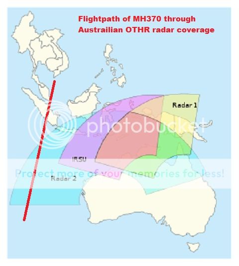
I think it might be possible the Australian Jindalee over the horizon radar may have tracked MH370. It is a very advanced radar system with a huge
range which is not like a conventional radar but bounces radar waves off the ionosphere. The southern track would put MH370 right in the radar's
tracking zone. Might be one reason they seem so certain it really is MH370 in the southern ocean.
Australia Silent On Whether OTH Radar Tracked MH370
www.aviationweek.com.../article-xml/awx_03_13_2014_p0-672073.xml
indiatoday.intoday.in...
Australia Silent On Whether OTH Radar Tracked MH370
Officially, Jindalee has a range of 3,000 km (1,900 mi.), about 1,500 km less than the distance to the point where MH370 disappeared, but the Royal Australian Air Force system is reputed to be able to reach the South China Sea, depending on atmospheric conditions.
Australia issues only limited information about Jindalee, whose three enormous antenna installations are spaced across the Outback.
www.aviationweek.com.../article-xml/awx_03_13_2014_p0-672073.xml
indiatoday.intoday.in...
edit on 27-3-2014 by
JimTSpock because: link
Arbitrageur
reply to post by AugustusMasonicus
That image shows a long straight line to the south, whereas the arc previously published by Inmarsat was curved.
It would be nice if Inmarsat would publish a map of the flight path, showing the estimated location at each of the hourly pings. The maps we've seen so far like that one and even the curved arc map by Inmarsat are inadequate because they don't show the full proper flight path with estimated ping location reference points.
Ive operated Inmarsat Stations and even Installed and commissioned them.
IMO Inmarsat is pulling an elaborate fast one. Lol
Zaphod58
reply to post by sy.gunson
Irrelevant, because no sea plane pilot is going to try to land in that ocean. They average 20 foot swells, which would destroy any seaplane trying to land, or take off.
The tv shows calm ocean.No twenty foot swells.And the seaplanes don't fly at 20 feet anyway.I fear it's just scaremongering generated of of ignorence.here there be dragons kind of scaremongering directed at ignorant people on ancient maps.
In any case your ship convoy has produced ZERO debris and they seem to be just chasing their tails after 2 weeks when my method would have produced instant results.
seaplane flies at 80 feet .you see debris you land instantly.
you take hi-def photos or put debris on board .you fly away.all done within 5 minutes.
reply to post by championoftruth
A 20 foot wave will cause a sea plane to crash on takeoff. You know absolutely nothing of what you are talking about. The Southern Indian Ocean is the must violent ocean on the planet. Just because you see pictures of calm seas doesn't mean it's always calm.
As for the wave height, a five foot wave or smaller can cause a sea plane to flip, or rip a hole in the fuselage. It doesn't matter if they fly at 80 feet, they have to land and takeoff again.
new topics
-
Where should Trump hold his next rally
2024 Elections: 41 minutes ago -
Shocking Number of Voters are Open to Committing Election Fraud
US Political Madness: 1 hours ago -
Gov Kristi Noem Shot and Killed "Less Than Worthless Dog" and a 'Smelly Goat
2024 Elections: 2 hours ago -
Falkville Robot-Man
Aliens and UFOs: 2 hours ago -
James O’Keefe: I have evidence that exposes the CIA, and it’s on camera.
Whistle Blowers and Leaked Documents: 3 hours ago -
Australian PM says the quiet part out loud - "free speech is a threat to democratic dicourse"...?!
New World Order: 3 hours ago -
Ireland VS Globalists
Social Issues and Civil Unrest: 4 hours ago -
Biden "Happy To Debate Trump"
2024 Elections: 4 hours ago -
RAAF airbase in Roswell, New Mexico is on fire
Aliens and UFOs: 5 hours ago -
What is the white pill?
Philosophy and Metaphysics: 6 hours ago
top topics
-
A Warning to America: 25 Ways the US is Being Destroyed
New World Order: 14 hours ago, 21 flags -
Blast from the past: ATS Review Podcast, 2006: With All Three Amigos
Member PODcasts: 7 hours ago, 11 flags -
Mike Pinder The Moody Blues R.I.P.
Music: 7 hours ago, 8 flags -
Biden "Happy To Debate Trump"
2024 Elections: 4 hours ago, 8 flags -
Australian PM says the quiet part out loud - "free speech is a threat to democratic dicourse"...?!
New World Order: 3 hours ago, 7 flags -
James O’Keefe: I have evidence that exposes the CIA, and it’s on camera.
Whistle Blowers and Leaked Documents: 3 hours ago, 6 flags -
What is the white pill?
Philosophy and Metaphysics: 6 hours ago, 5 flags -
Ireland VS Globalists
Social Issues and Civil Unrest: 4 hours ago, 4 flags -
RAAF airbase in Roswell, New Mexico is on fire
Aliens and UFOs: 5 hours ago, 4 flags -
Putin, Russia and the Great Architects of the Universe
ATS Skunk Works: 10 hours ago, 3 flags
active topics
-
Where should Trump hold his next rally
2024 Elections • 5 • : DontTreadOnMe -
University of Texas Instantly Shuts Down Anti Israel Protests
Education and Media • 306 • : Xtrozero -
Biden "Happy To Debate Trump"
2024 Elections • 38 • : JadedGhost -
Russia Ukraine Update Thread - part 3
World War Three • 5737 • : Arbitrageur -
Gov Kristi Noem Shot and Killed "Less Than Worthless Dog" and a 'Smelly Goat
2024 Elections • 26 • : CarlLaFong -
James O’Keefe: I have evidence that exposes the CIA, and it’s on camera.
Whistle Blowers and Leaked Documents • 8 • : Athetos -
Weinstein's conviction overturned
Mainstream News • 29 • : Xtrozero -
Shocking Number of Voters are Open to Committing Election Fraud
US Political Madness • 2 • : xuenchen -
Candidate TRUMP Now Has Crazy Judge JUAN MERCHAN After Him - The Stormy Daniels Hush-Money Case.
Political Conspiracies • 810 • : Annee -
Do you ever just get "bored" of everything?
Rant • 22 • : JonnyC555