It looks like you're using an Ad Blocker.
Please white-list or disable AboveTopSecret.com in your ad-blocking tool.
Thank you.
Some features of ATS will be disabled while you continue to use an ad-blocker.

Europe satellite picture , explain
page: 12
share:
I'm bored, so are you, lets play detective.
MOD: If its posted already, its nice to bring up old stuff once in a while. Here goes.
Explain your investigation regarding the picture.
Mod Edit: No Quote/Plagiarism – Please Review This Link.
Mod Edit: External Source Tags Instructions – Please Review This Link.
MOD: If its posted already, its nice to bring up old stuff once in a while. Here goes.
Source
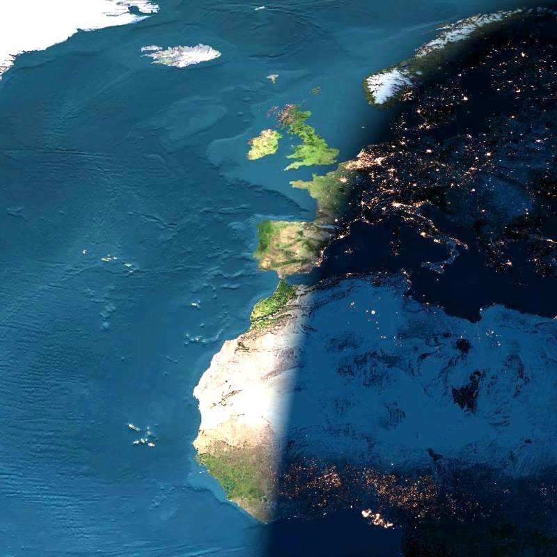
This image presents a remarkable view of the North Atlantic Ocean, stretching from the equator and western Africa northward to Iceland and Greenland, with sunset occurring over (north to south) Scandinavia, France, Spain, Algeria, Mali, and the Ivory Coast.
Here is an opportunity for you to play image detective. How on Earth was this image made? Is it a painting, or a map? Is it a photograph? If so, was it taken from a high-flying aircraft, or from outer space? Is it a satellite image, or possibly even something else?
Explain your investigation regarding the picture.
Mod Edit: External Source Tags Instructions – Please Review This Link.
edit on 6/3/2014 by ArMaP because: (no reason given)
reply to post by NullVoid
Taken from the crew aboard Columbia?
Explanation- I dropped it in google image search and that's what it said.
Taken from the crew aboard Columbia?
Explanation- I dropped it in google image search and that's what it said.
edit on 362014 by Holographicmeat because: added explanation
reply to post by NullVoid
Based on your title and nothing else, my guess is it's a satellite image of Europe from space. Why are you not convinced?
Based on your title and nothing else, my guess is it's a satellite image of Europe from space. Why are you not convinced?
Its the ' good versus evil ' boundary marker
Or in other words
Or in other words
earthobservatory.nasa.gov...
... it is composed of many elements, collected by a variety of instruments, at different times and places, with several wavelengths of light (and even sound)—combined in a computer to create an "impossible" view of the Earth.
The image itself was generated by the Earth and Moon Viewer, a Web-based tool that produces Earth imagery from several perspectives. The Earth daylit and night time images were developed by The Living Earth.
reply to post by NullVoid
Well this is embarrassing...
I thought you wrote the blurb, but you didn't.
visibleearth.nasa.gov...
Oh well, did I over detectiverise this?
Well this is embarrassing...
I thought you wrote the blurb, but you didn't.
visibleearth.nasa.gov...
Oh well, did I over detectiverise this?
reply to post by NullVoid
Initial thought was that I could see what I think is a plane travelling over the ocean so I must be considerably higher and then I wondered if it had been taken by someone on Concord, except I doubted the shape of the wing.
I am also curious about the colour of the Sahara and how it has extended to the West coast of Africa. The Ice/snow to the left of the picture is brilliant white but the white colour in Africa could possible be a very soft sand, but it looks very strange.
I can't get over how the UK looks as though its basking in sunlight whilst to the East it appears that heavy snow or ice shows through. Usually the UK does not get off so lightly weatherwise.
I also wondered about whether we are seeing a slightly lower sea level as there appear to be more islands in the Atlantic than I remember being there.
Its a beautiful picture though. I hope others have a better handle on it than I.
reply to post by NullVoid
a composite piece of artwork - that fails to give a clear picture - it may look pretty - but there are so many things wrong - it hurts
a composite piece of artwork - that fails to give a clear picture - it may look pretty - but there are so many things wrong - it hurts
wow - there were no replies when I started mine - but got distracted
though I think the OP wanted to know what other members opinions / deductions were - not simply quote the image source captions
though I think the OP wanted to know what other members opinions / deductions were - not simply quote the image source captions
reply to post by NullVoid
No single spacecraft or astronaut took this picture. It is a digital composite of archived images taken by several Earth-orbiting satellites and ocean-faring ships. Similar images can be digitally stitched together for any Earth location by John Walker's Earth and Moon Viewer website. Specifically, the daytime land images were taken by the MODIS instrument on NASA's Terra satellite, while the nighttime images were taken by the DMSP satellites. This image is different from what an astronaut would see for reasons including a complete lack of clouds and an unrealistic exaggeration of lights and contrasts. The image has become both an internet wave in that it continues to circulate as an attachment to digital correspondence, and a modern urban legend.
i found this quoted on www.hoax-slayer.com... so i guess it's all the things you said
reply to post by NullVoid
Well, obviously the ocean bottom can not be optically seen even from space as it is under several miles of water in places and the mid atlantic ridge among other features is invisible except for non optical frequency's such as radio and radar which suffer severe scattereing due to oceanic water compositon, the light's in the shaded area may suggest that this is a composite of several images or even a overlay of a topographical satellite image with an optical image, it is extremely rare for that much of nothern and western europe and the atlantic to be that clear of cloud and even when it is, it is usually acompanyed by haze (remember it is heavily industrialized and even though the more polluting industry's have long transferred themselves to asia these country's have more cars and people than most other part's of the world in referrence to overall area.
I for one would love a clear map of the ocean bottom but that is not what you have here, this is an overlay at best or a computer composite at worst.
Still a great image.
EDIT OR WHAT ELTON SAID, I should have read that before I posted,
edit on 6-3-2014 by LABTECH767 because: (no reason given)
hellobruce
earthobservatory.nasa.gov...
You killed the detective work, some posters (me included) got it wrong.
I did not even aware of the sea topology until I read the answer. And I got wrong in most of the explanation, like how Sahara will not reflect light, should be black, so it will not visible, the sunset light should be straight etc etc.
For those who answered and made up your mind, visit the link above for the correct explanation.
Moral: We have to accept that not all of our assumption are correct, its very enlightening to accept and be corrected and its really worth it to learn where we got it wrong.
So, in your next post in ATS, think about this moral, the other guy actually maybe got it right and you are wrong.
Next guessing game: Chart
edit on 6-3-2014 by NullVoid because: (no reason given)
new topics
-
Where should Trump hold his next rally
2024 Elections: 1 hours ago -
Shocking Number of Voters are Open to Committing Election Fraud
US Political Madness: 1 hours ago -
Gov Kristi Noem Shot and Killed "Less Than Worthless Dog" and a 'Smelly Goat
2024 Elections: 2 hours ago -
Falkville Robot-Man
Aliens and UFOs: 2 hours ago -
James O’Keefe: I have evidence that exposes the CIA, and it’s on camera.
Whistle Blowers and Leaked Documents: 3 hours ago -
Australian PM says the quiet part out loud - "free speech is a threat to democratic dicourse"...?!
New World Order: 4 hours ago -
Ireland VS Globalists
Social Issues and Civil Unrest: 4 hours ago -
Biden "Happy To Debate Trump"
2024 Elections: 5 hours ago -
RAAF airbase in Roswell, New Mexico is on fire
Aliens and UFOs: 5 hours ago -
What is the white pill?
Philosophy and Metaphysics: 6 hours ago
top topics
-
A Warning to America: 25 Ways the US is Being Destroyed
New World Order: 15 hours ago, 21 flags -
Blast from the past: ATS Review Podcast, 2006: With All Three Amigos
Member PODcasts: 7 hours ago, 11 flags -
Mike Pinder The Moody Blues R.I.P.
Music: 7 hours ago, 8 flags -
Biden "Happy To Debate Trump"
2024 Elections: 5 hours ago, 8 flags -
James O’Keefe: I have evidence that exposes the CIA, and it’s on camera.
Whistle Blowers and Leaked Documents: 3 hours ago, 7 flags -
Australian PM says the quiet part out loud - "free speech is a threat to democratic dicourse"...?!
New World Order: 4 hours ago, 7 flags -
What is the white pill?
Philosophy and Metaphysics: 6 hours ago, 5 flags -
Ireland VS Globalists
Social Issues and Civil Unrest: 4 hours ago, 4 flags -
RAAF airbase in Roswell, New Mexico is on fire
Aliens and UFOs: 5 hours ago, 4 flags -
Putin, Russia and the Great Architects of the Universe
ATS Skunk Works: 10 hours ago, 3 flags
active topics
-
Candidate TRUMP Now Has Crazy Judge JUAN MERCHAN After Him - The Stormy Daniels Hush-Money Case.
Political Conspiracies • 811 • : Oldcarpy2 -
Shocking Number of Voters are Open to Committing Election Fraud
US Political Madness • 3 • : Disgusted123 -
Meadows, Giuliani Among 11 Indicted in Arizona in Latest 2020 Election Subversion Case
Mainstream News • 28 • : yuppa -
SETI chief says US has no evidence for alien technology. 'And we never have'
Aliens and UFOs • 77 • : yuppa -
Biden "Happy To Debate Trump"
2024 Elections • 39 • : underpass61 -
Where should Trump hold his next rally
2024 Elections • 6 • : WeMustCare -
University of Texas Instantly Shuts Down Anti Israel Protests
Education and Media • 306 • : Xtrozero -
Russia Ukraine Update Thread - part 3
World War Three • 5737 • : Arbitrageur -
Gov Kristi Noem Shot and Killed "Less Than Worthless Dog" and a 'Smelly Goat
2024 Elections • 26 • : CarlLaFong -
James O’Keefe: I have evidence that exposes the CIA, and it’s on camera.
Whistle Blowers and Leaked Documents • 8 • : Athetos
2